EARTHQUAKES IN ALASKA October 2007 ALASKA EARTHQUAKE INFORMATION CENTER
|
|
|
- Dinah McCoy
- 5 years ago
- Views:
Transcription

1 EARTHQUAKES IN ALASKA October 2007 ALASKA EARTHQUAKE INFORMATION CENTER A report of the Alaska State Seismologist s Office
 474-7320; FAX: (907) 474-5618 E-MAIL: aeic@giseis.alaska.edu EARTHQUAKES IN ALASKA - October 2007 By N. Ruppert with the assistance of N. Kozyreva and J.")
2 Alaska Earthquake Information Center Geophysical Institute, University of Alaska 903 Koyukuk Drive, P.O. Box Fairbanks, AK TEL: (907) ; FAX: (907) EARTHQUAKES IN ALASKA - October 2007 By N. Ruppert with the assistance of N. Kozyreva and J. Roush Issued: January, 2008 The Alaska Earthquake Information Center is a cooperative program between the Geophysical Institute of the University of Alaska and the U.S. Geological Survey with the support from the Earthquake Hazards Program. DISCLAIMER This report has not been edited or reviewed for conformity with U. S. Geological Survey and State of Alaska standards and nomenclature. The data in this report are preliminary and subject to revision. Most of the earthquake parameters have been determined by AEIC. The data are released on the condition that neither the U.S. Geological Survey, nor the United States Government, nor the Geophysical Institute, University of Alaska Fairbanks may be held liable for any damages resulting from its authorized or unauthorized use. Alaska State Seismologist s Report
3 The Alaska Earthquake Information Center (AEIC) is a cooperative program established to monitor earthquakes in Alaska and to provide earthquake information to citizens and public officials and to the earth science community. Most of the earthquakes located by AEIC occur in a core area in central and southern Alaska, between latitudes 57 o N and 67 o N, and longitudes 135 o W and 156 o W; however, this listing also includes earthquakes not located by AEIC but reported in the National Earthquake Information Center s (NEIC) monthly Preliminary Determination of Epicenters (PDE) for a larger region between latitudes 48 o N and 75 o N, and longitudes 130 o W to 170 o E. The magnitude level for completeness and the precision of the locations vary across the state due to uneven station spacing and to differences in earthquake depths. The data are more complete and the hypocenters are more accurate in regions where the station density is greatest. In southern and central Alaska where the majority of the stations are located, the earthquake catalogs are complete for shallow (depth < 30 km) earthquakes of about magnitude 1.5 and larger. The magnitude threshold at which the catalogs are complete increases with depth. For earthquakes deeper than 100 km in southern and central Alaska, the catalogs are complete above about magnitude 2.0. The earthquake catalogs are reasonably complete for the entire state for events greater than or equal to magnitude 3.0. Earthquakes in southern and central Alaska, where calculated hypocenters are more accurate, have horizontal (epicentral) and vertical (depth) errors (median value) of 1.1 and 1.9 km, respectively. Neogene and younger faults plotted on the seismicity figures are modified from: Plafker, G., Gilpin, L., and Lahr, J.C., 1994, Neotectonic map of Alaska, in Plafker, G., and Berg, H.C., eds., The geology of Alaska: Boulder, Colorado, Geological Society of America, The Geology of North America, v. G-1, plate 12, scale 1:2,500,000. The seismicity shown for western Canada is not complete, and does not represent the total activity for the area. For more information on Canadian seismicity, contact: Pacific Geoscience Center, Geological Survey of Canada, P.O. Box 6000 Sidney, British Columbia, V8L 4B2 Canada. Cover Seismic monitoring site ISLE in the Wrangell-St.Elias mountains region, southern Alaska. Photo by S. Estes, AEIC, Geophysical Institute, UAF. Acknowledgments Supplemental data provided by the United States Geological Survey, National Earthquake Information Center, Golden, Colorado; the Geological Survey of Canada, Pacific Geoscience Centre, Sidney, British Columbia; the Alaska Volcano Observatory, Anchorage, Alaska; and the National Oceanic and Atmospheric Administration, National Weather Service, Alaska Tsunami Warning Center, Palmer, Alaska.
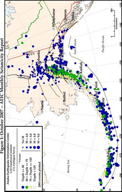
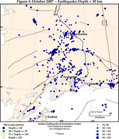
4 CONTENTS This monthly earthquake catalog contains the following: Highlights: Summary plot: Maps and cross-sections: Listings: A discussion of important or particularly interesting earthquakes which occurred during the month. A plot with the earthquake statistics: time-magnitude plot, number of located events per day, cumulative number of located events, depth histogram, frequency-magnitude relationship for the Aleutian and mainland Alaska events. Five maps illustrating Alaska seismicity during the month. Figure 1 is a map which includes all located earthquakes for the state and surrounding region. Figure 2a focuses on earthquakes in a core area of central and southern Alaska, and depicts line segments for two cross-sections through the Alaska/ Aleutian Wadati Benioff zone (Figure 2b). Figure 3 shows events in the core area larger than magnitude 3.0, Figure 4 shows all core events shallower than 30 km depth, and Figure 5 shows all core events of depth greater than or equal to 30 km. Three listings of hypocenters are presented, as follows: first, a complete listing of all located earthquakes for the month, corresponding to the epicenters plotted in Figure 1; next, Appendix 1 contains a subset of the full listing restricted to only those events of magnitude 4.0 and larger; and lastly, Appendix 2 lists known or suspected quarry blasts during the month. These blasts have been excluded from Figures 1-5. Listings include, for each event: date and origin time, epicenter, depth, preferred magnitude, solution quality statistics and comments (region, alternate magnitudes, available felt reports and other remarks). Other types of information available regularly from AEIC: Parameters for the most recent 100 earthquakes of magnitude 2.0 and larger are available through the Internet ( OR by sending to quake@giseis.alaska.edu; in the latter case a return message will contain the earthquake listing. Weekly and Monthly Seismicity Reports - issued within seven days of the end of each week and month, respectively. These reports include highlights of recent activity, a preliminary listing of events, and epicenter maps. The weekly and monthly reports may be found on the Internet at Catalog of Alaska Earthquake Focal Mechanisms - annual catalogs of focal mechanisms determined from initial P-wave polarities recorded by the regional seismograph network, as well as source mechanisms determined independently by NEIC and other seismic observatories. 1
 occurred on October 2 in the Alaska Peninsula region of Alaska. Ten events were felt.")
 SSE of King Cove and 99 km (62 miles) SE of Cold Bay.")
5 HIGHLIGHTS During October, 2007, the Alaska Earthquake Information Center located 2,093 events, thirty seven of which had magnitudes equal to or greater than 4.0 and twenty three of which were suspected quarry blasts. The largest event (M6.3) occurred on October 2 in the Alaska Peninsula region of Alaska. Ten events were felt. Earthquakes of particular interest during the month are discussed below: October 2, 18:00:07 UTC (10:00 am ADT), M W 6.3, M L 6.0, mb 6.2, M S 6.2, o N o W, depth=28.9 km: A strong earthquake occurred in the Alaska Peninsula region and was located 71 km (45 miles) SSE of King Cove and 99 km (62 miles) SE of Cold Bay. It was felt in Cold Bay, King Cove and Sand Point, with maximum intensity of shaking VI, strong. The AEIC located over 400 aftershocks with magnitudes 2.0 and greater through the end of the month. Fifteen aftershocks had magnitudes 4.0 or greater of which four had magnitudes greater than 5. The largest aftershock of magnitude 5.6 occurred three minutes after the mainshock. This earthquake is the largest to occur in the region since the M6.2 event on November 20, The October 2, 2007 earthquake occurred on the convergent boundary between the subducting Pacific and the overriding North American crustal plates. The current sequence of earthquakes is located within the so-called Shumagin seismic gap. According to the crust deformation measurements, no significant strain is being accumulated within the gap. October 3, 14:06:12 UTC (6:06 am ADT), M L 5.0, M W 5.2, m b 5.0, M S 4.4, o N o W, depth=45.5 km: A moderate earthquake occurred in the Kodiak Island region and was located 86 km (54 miles) NE of Kodiak and 153 km (96 miles) S of Homer. It was felt in Kodiak and Homer, maximum intensity IV, light. The waveform radiation pattern indicates strike-slip faulting. The depth and focal mechanism of the event indicate that it occurred inside the subducting Pacific plate 2
6 SUMMARY PLOT A summary plot of events with magnitudes. The lower left panel shows number of the located events per day, their magnitudes, and the cumulative number. The upper left panel is the depth histogram. The right panel shows the frequency-magnitude distribution of the Aleutian Islands (upper figure) and the mainland Alaska (lower figure) earthquakes with estimates of the b-value and magnitude of completeness. 2007/10/1 2007/10/31: 2091 earthquakes Aleutian Islands, b (M>2.5)= / # of events Depth in [km] Cumulative Number Cumulative # Magnitude Mainland Alaska, b (M > 1.4) = / # per day Magnitude day Cumulative Number Magnitude 3
7 4
8 5
9 6
10 7
11 8

12 9
13 Monthly Listing of Earthquake Hypocenters in Alaska Events are listed in chronological order. The following data are given for each event: 1. DATE AND TIME in Coordinated Universal Time (UTC): year (YR), month (MO), day (DY), hour (HR), minute (MN) and second (SEC). To convert to Alaska Standard Time (AST) or Alaska Daylight Time (ADT) subtract 9 or 8 hours, respectively. 2. LATITUDE and LONGITUDE of epicenter in degrees (DEG) and minutes (MIN). 3. DEPTH, depth of focus in kilometers. Symbols after the depth indicate the following: N = Depth was fixed at 33 km for earthquakes whose character on seismograms indicates a shallow focus but whose depth is not satisfactorily determined by the data. D = Depth was restrained by the computer program based on 2 or more compatible pp phases and/or unidentified secondary arrivals used as pp. G = Depth was fixed at other than 33 km. * or? = Less well-constrained free depth determined by NEIC. For detailed explanation see January 1993 Preliminary Determation of Epicenters. 4. PREF MAG, the AEIC ML is the preferred magnitude, unless it is unavailable or when the National Earthquake Information Center (NEIC) m b > 4.5 or M S > 6.8. For preferred magnitudes other than AEIC ML a letter code after the magnitude indicates the type as follows: mb = Body-wave magnitude (Mb) computed by NEIS. Ms = Surface wave magnitude (MS) computed by NEIS. A = Local magnitude (ML) from Alaska Tsunami Warning Center, Palmer, Alaska (PMR). C = Local magnitude (ML) from Pacific Geoscience Centre, Sidney, British Columbia, Canada (PGC). D = Duration magnitude (MD) from AEIC. L = Duration magnitude (MD) from Columbia University, Lamont-Doherty Earth Observatory, Palisades, New York (PAL). 5. RMS, root-mean-square traveltime residual in seconds: RMS = W i R i 2 Where R i is the observed minus computed time of the i-th observation. W i is the corresponding weight of the observation, and weights are normalized so that their sum equals N, the total number of P, S, and S-P observations used in the solution. 6. SEH, standard error in the horizontal direction with least control in kilometers. 7. SEZ, standard error of depth in kilometers. 8. GAP, largest azimuthal separation between stations in degrees with respect to the epicenter. 9. PHASES, number of P and S phases used in the solution. 10. MIN DIS, epicentral distance in kilometers to the station closest to the epicenter. 11. Q, quality of the hypocenter. This index is a measure of the precision of the hypocenter and is calculated from SEH and SEZ: Q Larger of SEH and SEZ (km) A < 1.34 B < 2.67 C < 5.35 D > T, event type as follows: E - Local or regional tectonic earthquake located by AEIC. a - Volcano-tectonic earthquake located by AEIC. B - Long period volcano earthquake located by AEIC. R - Regional event not located by AEIC. Q - Known or suspected quarry or mine blast located by AEIC. 13. COMMENTS, symbols and abbreviations used in comments: BRK - University of California, Berkeley. Mo - Seismic moment. NEIS - U.S. Geological Survey, National Earthquake Information Service. PAL - Columbia University, Lamont-Doherty Earth Observatory, Palisades, New York. PAS - California Institute of Technology, Pasadena. PGC - Pacific Geoscience Centre, Sidney, British Columbia, Canada. PMR - Alaska Tsunami Warning Center, Palmer, Alaska. PPT - Laboratoire de Geophysique, Papeete, French Polynesia. SPEC - An NEIS solution based on use of dense local networks, a local crustal model, or other methods not routinely applied in calculating the hypocenter parameters. Errors and uncertainties in the reported parameters may result from random errors present in the phase data, or from systematic errors introduced either by the velocity models used to locate the earthquakes or by poor geometrical distribution of recording stations about the source. One should be particularly cautious using solutions that have GAP > 180 degrees, PHASES < 6, MIN DIS > DEPTH, RMS > 1s, SEH > 5km, or SEZ > 10km. Solutions with A and B quality are generally more reliable, but this does not guarantee that the accuracy of the solutions is within the limits implied by SEH and SEZ. Catalogs prior to January 1998 have printed SEH and SEZ values that are too large by a factor of N i N 10
14 AEIC Monthly Earthquake Listing DATE LAT LON DEPTH MAG RMS SEH SEZ GAP PHASES MIN Q T REGION yy mo dy jday hh:mn:sec DEG DEG km mb ML sec. km km deg P,S DIS (274) 00:03: A E CENTRAL ALASKA (274) 01:25: A E CENTRAL ALASKA (274) 02:20: A E CENTRAL ALASKA (274) 02:50: A E CENTRAL ALASKA (274) 03:27: A E CENTRAL ALASKA (274) 03:31: A E SOUTHERN ALASKA (274) 04:26: A E CENTRAL ALASKA (274) 04:55: A E SOUTHERN ALASKA (274) 05:08: G B G SOUTHEASTERN ALASKA (274) 05:22: A E SOUTHERN ALASKA (274) 05:36: A E CENTRAL ALASKA (274) 05:58: A E SOUTHERN ALASKA (274) 06:04: A E CENTRAL ALASKA (274) 06:22: C E ALASKA (274) 06:59: A E CENTRAL ALASKA (274) 07:28: D E GULF OF ALASKA (274) 08:04: A E SOUTHERN ALASKA (274) 08:16: A E SOUTHERN ALASKA (274) 09:31: A E CENTRAL ALASKA (274) 10:06: A E CENTRAL ALASKA (274) 10:40: A E CENTRAL ALASKA (274) 11:22: A E CENTRAL ALASKA (274) 11:31: G A E CENTRAL ALASKA (274) 11:50: A E CENTRAL ALASKA (274) 12:24: G A E CENTRAL ALASKA (274) 12:43: A E CENTRAL ALASKA (274) 13:55: A E CENTRAL ALASKA (274) 14:19: A E SOUTHERN ALASKA (274) 14:32: A E CENTRAL ALASKA (274) 14:58: G A E CENTRAL ALASKA (274) 16:06: A E CENTRAL ALASKA (274) 16:19: A E CENTRAL ALASKA (274) 16:20: A E CENTRAL ALASKA (274) 16:50: A E CENTRAL ALASKA (274) 17:41: D E FOX ISLANDS, ALEUTIAN IS (274) 17:47: A E ALASKA PENINSULA (274) 17:55: A E CENTRAL ALASKA (274) 19:03: A E CENTRAL ALASKA (274) 19:26: A E CENTRAL ALASKA (274) 19:50: A E KODIAK ISLAND REGION (274) 19:51: A E KODIAK ISLAND REGION (274) 19:54: A E CENTRAL ALASKA (274) 20:28: A E CENTRAL ALASKA (274) 21:18: A E SOUTHERN ALASKA (274) 21:59: A E CENTRAL ALASKA (274) 22:10: G A E CENTRAL ALASKA (274) 22:11: G A E CENTRAL ALASKA (274) 22:28: D E NORTHERN YUKON TERR., CAN (274) 23:14: G A Q CENTRAL ALASKA (275) 00:59: A E FOX ISLANDS, ALEUTIAN IS (275) 01:04: A E ANDREANOF IS., ALEUTIAN IS (275) 01:33: A E KODIAK ISLAND REGION (275) 01:34: D E ALASKA (275) 01:43: A E CENTRAL ALASKA (275) 02:01: G C G SOUTHEASTERN ALASKA (275) 02:13: A E ANDREANOF IS., ALEUTIAN IS (275) 03:44: A E CENTRAL ALASKA (275) 04:13: D E RAT ISLANDS, ALEUTIAN IS (275) 04:39: A E CENTRAL ALASKA (275) 06:14: C E ANDREANOF IS., ALEUTIAN IS. 11
15 (275) 06:43: A E CENTRAL ALASKA (275) 07:09: B E RAT ISLANDS, ALEUTIAN IS (275) 07:41: A E SOUTHERN ALASKA (275) 09:22: A E CENTRAL ALASKA (275) 09:23: A E ANDREANOF IS., ALEUTIAN IS (275) 09:41: A E KENAI PENINSULA, ALASKA (275) 09:48: A E ANDREANOF IS., ALEUTIAN IS (275) 11:42: A E KENAI PENINSULA, ALASKA (275) 11:53: A E CENTRAL ALASKA (275) 12:35: B E CENTRAL ALASKA (275) 12:41: A E CENTRAL ALASKA (275) 13:21: G A E CENTRAL ALASKA (275) 13:48: G A G SOUTHEASTERN ALASKA (275) 14:00: A E ALASKA PENINSULA (275) 14:16: A E KENAI PENINSULA, ALASKA (275) 14:35: A E CENTRAL ALASKA (275) 15:56: A E CENTRAL ALASKA (275) 16:14: D E ALASKA PENINSULA (275) 16:46: G A G SOUTHEASTERN ALASKA (275) 17:00: A E SOUTHERN ALASKA (275) 17:22: G A G SOUTHEASTERN ALASKA (275) 18:00: B F ALASKA PENINSULA Felt in King Cove, Cold Bay, and Sand Point. Maximum intensity VI (275) 18:02: D E ALASKA PENINSULA (275) 18:03: C E ALASKA PENINSULA (275) 18:05: D E ALASKA PENINSULA (275) 18:06: D E ALASKA PENINSULA (275) 18:08: D E ALASKA PENINSULA (275) 18:09: D E ALASKA PENINSULA (275) 18:11: D E ALASKA PENINSULA (275) 18:13: D E ALASKA PENINSULA (275) 18:17: B E ALASKA PENINSULA (275) 18:19: C E ALASKA PENINSULA (275) 18:21: D E ALASKA PENINSULA (275) 18:22: B E ALASKA PENINSULA (275) 18:25: D E ALASKA PENINSULA (275) 18:26: D E ALASKA PENINSULA (275) 18:27: C E ALASKA PENINSULA (275) 18:28: D E ALASKA PENINSULA (275) 18:29: C E ALASKA PENINSULA (275) 18:32: D E ALASKA PENINSULA (275) 18:34: D E ALASKA PENINSULA (275) 18:34: C E ALASKA PENINSULA (275) 18:39: D E ALASKA PENINSULA (275) 18:41: C E ALASKA PENINSULA (275) 18:42: C E ANDREANOF IS., ALEUTIAN IS (275) 18:47: D E ALASKA PENINSULA (275) 18:48: D E ALASKA PENINSULA (275) 18:49: D E ALASKA PENINSULA (275) 18:51: B E ALASKA PENINSULA (275) 18:54: C E ALASKA PENINSULA (275) 18:57: D E ALASKA PENINSULA (275) 18:58: D E ALASKA PENINSULA (275) 19:00: B E ALASKA PENINSULA (275) 19:03: C E ALASKA PENINSULA (275) 19:09: C E ALASKA PENINSULA (275) 19:16: D E ALASKA PENINSULA (275) 19:16: D E ALASKA PENINSULA (275) 19:20: D E ALASKA PENINSULA (275) 19:24: B E ALASKA PENINSULA (275) 19:27: B E ALASKA PENINSULA (275) 19:41: D E ALASKA PENINSULA (275) 19:45: D E ALASKA PENINSULA (275) 19:47: B E FOX ISLANDS, ALEUTIAN IS (275) 19:51: D E FOX ISLANDS, ALEUTIAN IS (275) 19:57: D E ALASKA PENINSULA (275) 19:59: D E ALASKA PENINSULA (275) 20:06: D E ALASKA PENINSULA 12
16 (275) 20:07: D E ALASKA PENINSULA (275) 20:12: A E KODIAK ISLAND REGION (275) 20:22: B E ALASKA PENINSULA (275) 20:31: B E CENTRAL ALASKA (275) 20:31: B E ALASKA PENINSULA (275) 20:35: D E ALASKA PENINSULA (275) 20:39: A E SOUTHERN ALASKA (275) 20:39: D E ALASKA PENINSULA (275) 20:44: D E ALASKA PENINSULA (275) 20:45: A E ANDREANOF IS., ALEUTIAN IS (275) 20:47: D E ALASKA PENINSULA (275) 20:49: D E ALASKA PENINSULA (275) 20:53: D E ALASKA PENINSULA (275) 20:53: A E ANDREANOF IS., ALEUTIAN IS (275) 20:54: D E ALASKA PENINSULA (275) 20:57: B E ALASKA PENINSULA (275) 20:57: D E ALASKA PENINSULA (275) 21:00: D E ALASKA PENINSULA (275) 21:01: D E ALASKA PENINSULA (275) 21:02: D E ALASKA PENINSULA (275) 21:05: B E ALASKA PENINSULA (275) 21:08: C E ALASKA PENINSULA (275) 21:09: A E CENTRAL ALASKA (275) 21:10: C E ALASKA PENINSULA (275) 21:12: D E ALASKA PENINSULA (275) 21:16: D E ALASKA PENINSULA (275) 21:18: G D E ALASKA PENINSULA (275) 21:19: D E ALASKA PENINSULA (275) 21:24: D E ALASKA PENINSULA (275) 21:25: A E CENTRAL ALASKA (275) 21:28: D E ALASKA PENINSULA (275) 21:31: D E ALASKA PENINSULA (275) 21:32: A E ALASKA PENINSULA (275) 21:33: D E ALASKA PENINSULA (275) 21:35: D E ALASKA PENINSULA (275) 21:38: B E ALASKA PENINSULA (275) 21:40: D E ALASKA PENINSULA (275) 21:47: C E ALASKA PENINSULA (275) 21:58: G A G SOUTHEASTERN ALASKA (275) 21:59: B E ALASKA PENINSULA (275) 22:01: D E ALASKA PENINSULA (275) 22:01: D E ALASKA PENINSULA (275) 22:05: D E ALASKA PENINSULA (275) 22:08: D E ALASKA PENINSULA (275) 22:11: D E ALASKA PENINSULA (275) 22:18: D E ALASKA PENINSULA (275) 22:20: A E CENTRAL ALASKA (275) 22:21: C E ALASKA PENINSULA (275) 22:24: D E ALASKA PENINSULA (275) 22:25: D E ALASKA PENINSULA (275) 22:43: A E SOUTHERN ALASKA (275) 22:44: B E ALASKA PENINSULA (275) 22:50: G D E ALASKA PENINSULA (275) 22:59: B E ALASKA PENINSULA (275) 23:03: G A Q CENTRAL ALASKA (275) 23:04: D E ALASKA PENINSULA (275) 23:09: D E ALASKA PENINSULA (275) 23:15: D E ALASKA PENINSULA (275) 23:25: A E ALASKA PENINSULA (275) 23:37: B E ALASKA PENINSULA (275) 23:39: D E ALASKA PENINSULA (275) 23:42: D E ALASKA PENINSULA (275) 23:53: D E ALASKA PENINSULA (276) 00:12: D E ALASKA PENINSULA (276) 00:14: D E ALASKA PENINSULA (276) 00:21: D E ALASKA PENINSULA (276) 00:21: D E ALASKA PENINSULA (276) 00:27: G D E SOUTH OF ALASKA 13
17 (276) 00:57: D E ALASKA PENINSULA (276) 00:58: D E ALASKA PENINSULA (276) 01:10: D E ALASKA PENINSULA (276) 01:11: B E CENTRAL ALASKA (276) 01:26: D E ALASKA PENINSULA (276) 01:28: D E ANDREANOF IS., ALEUTIAN IS (276) 01:40: C E ALASKA PENINSULA (276) 01:51: C E ALASKA PENINSULA (276) 01:51: B E ALASKA PENINSULA (276) 02:01: C E ANDREANOF IS., ALEUTIAN IS (276) 02:03: B E ALASKA PENINSULA (276) 02:06: C E ALASKA PENINSULA (276) 02:07: B E ALASKA PENINSULA (276) 02:08: D E ALASKA PENINSULA (276) 02:09: D E ALASKA PENINSULA (276) 02:19: D E ALASKA PENINSULA (276) 02:21: D E CENTRAL ALASKA (276) 02:25: A E ANDREANOF IS., ALEUTIAN IS (276) 02:31: D E ALASKA PENINSULA (276) 02:54: D E ALASKA PENINSULA (276) 02:57: C E ALASKA PENINSULA (276) 02:58: D E ALASKA PENINSULA (276) 03:08: G D E GULF OF ALASKA (276) 03:20: D E CENTRAL ALASKA (276) 03:51: D E ALASKA PENINSULA (276) 03:54: D E ALASKA PENINSULA (276) 04:10: D E ANDREANOF IS., ALEUTIAN IS (276) 04:30: D E ALASKA PENINSULA (276) 04:34: D E CENTRAL ALASKA (276) 04:48: D E ALASKA PENINSULA (276) 05:01: D E ALASKA PENINSULA (276) 05:28: C E CENTRAL ALASKA (276) 05:30: N/A B E SOUTHERN ALASKA (276) 05:34: D E CENTRAL ALASKA (276) 05:44: A E CENTRAL ALASKA (276) 06:01: A E CENTRAL ALASKA (276) 06:04: D E ALASKA PENINSULA (276) 06:11: D E ALASKA PENINSULA (276) 06:19: C E ALASKA PENINSULA (276) 06:30: D E ALASKA PENINSULA (276) 06:35: D E ALASKA PENINSULA (276) 06:42: D E ALASKA PENINSULA (276) 06:51: C E ALASKA PENINSULA (276) 06:59: A E CENTRAL ALASKA (276) 07:28: A E CENTRAL ALASKA (276) 07:40: A E CENTRAL ALASKA (276) 07:40: A E SOUTHERN ALASKA (276) 07:42: C E ALASKA PENINSULA (276) 07:43: D E ALASKA PENINSULA (276) 07:59: B E CENTRAL ALASKA (276) 08:08: C E ALASKA PENINSULA (276) 08:18: C E ALASKA PENINSULA (276) 08:22: C E CENTRAL ALASKA (276) 08:29: C E ALASKA PENINSULA (276) 08:38: C E ALASKA PENINSULA (276) 09:15: B E ANDREANOF IS., ALEUTIAN IS (276) 09:44: C E ALASKA PENINSULA (276) 09:53: B E ALASKA PENINSULA (276) 09:55: D E ANDREANOF IS., ALEUTIAN IS (276) 10:10: G D G SOUTHEASTERN ALASKA (276) 10:33: C E ALASKA PENINSULA (276) 10:34: A E ALASKA PENINSULA (276) 10:45: G D E SOUTH OF ALASKA (276) 10:56: C E ALASKA PENINSULA (276) 11:08: C E ALASKA PENINSULA (276) 11:12: D E SOUTHERN ALASKA (276) 11:18: C E ALASKA PENINSULA 14
18 (276) 11:32: C E ALASKA PENINSULA (276) 11:37: D E ALASKA PENINSULA (276) 11:48: A E SOUTHERN ALASKA (276) 11:50: C E ALASKA PENINSULA (276) 11:59: C E ALASKA PENINSULA (276) 12:00: G D E ALASKA (276) 12:14: B E SOUTHERN ALASKA (276) 12:37: C E ALASKA PENINSULA (276) 12:40: C E ALASKA PENINSULA (276) 12:45: C E ALASKA PENINSULA (276) 12:52: A E CENTRAL ALASKA (276) 12:57: C E ALASKA PENINSULA (276) 13:02: D E ALASKA PENINSULA (276) 13:02: C E ALASKA PENINSULA (276) 13:36: B E ALASKA PENINSULA (276) 13:40: D E ALASKA PENINSULA (276) 13:41: D E CENTRAL ALASKA (276) 13:48: D E ALASKA PENINSULA (276) 14:06: A F KODIAK ISLAND REGION Felt in Homer and Kodiak. Maximum intensity IV (276) 14:21: C E UNIMAK ISLAND REGION (276) 14:25: C E ALASKA PENINSULA (276) 14:30: D E ALASKA PENINSULA (276) 14:35: C E ALASKA PENINSULA (276) 14:50: B E ALASKA PENINSULA (276) 14:55: D E KODIAK ISLAND REGION (276) 14:56: D E ALASKA PENINSULA (276) 14:56: C E ALASKA PENINSULA (276) 15:08: D E ALASKA PENINSULA (276) 15:17: D E ALASKA PENINSULA (276) 15:18: C E CENTRAL ALASKA (276) 15:25: C E ALASKA PENINSULA (276) 15:25: C E CENTRAL ALASKA (276) 15:32: C E ALASKA PENINSULA (276) 15:40: C E ALASKA PENINSULA (276) 15:42: D E SOUTHERN ALASKA (276) 15:47: B E ALASKA PENINSULA (276) 15:49: C E ALASKA PENINSULA (276) 16:06: C E ALASKA PENINSULA (276) 16:36: D E ALASKA PENINSULA (276) 17:00: C E ALASKA PENINSULA (276) 17:21: C E ALASKA PENINSULA (276) 17:24: D E ANDREANOF IS., ALEUTIAN IS (276) 17:40: C E ALASKA PENINSULA (276) 18:09: D E ALASKA PENINSULA (276) 18:09: C E ALASKA PENINSULA (276) 18:12: A E SOUTHEASTERN ALASKA (276) 18:15: C E ALASKA PENINSULA (276) 18:17: C E ALASKA PENINSULA (276) 18:19: C E ALASKA PENINSULA (276) 18:32: D E ALASKA PENINSULA (276) 18:38: D E ANDREANOF IS., ALEUTIAN IS (276) 19:02: A E CENTRAL ALASKA (276) 19:25: G A G SOUTHEASTERN ALASKA (276) 19:31: D E UNIMAK ISLAND REGION (276) 19:35: D E ALASKA PENINSULA (276) 19:38: D E ALASKA PENINSULA (276) 20:05: B a FOX ISLANDS, ALEUTIAN IS (276) 20:05: C E ALASKA PENINSULA (276) 20:23: C E ALASKA PENINSULA (276) 20:37: D E ALASKA PENINSULA (276) 21:22: C E SOUTHERN ALASKA (276) 21:29: G A G SOUTHEASTERN ALASKA (276) 21:45: C E ALASKA PENINSULA (276) 21:49: D E ALASKA PENINSULA (276) 22:21: A E CENTRAL ALASKA (276) 22:46: D E ALASKA PENINSULA (276) 22:46: D E ALASKA PENINSULA 15
19 (276) 22:48: D E ALASKA PENINSULA (276) 22:51: B E ALASKA PENINSULA (276) 23:05: D E ALASKA PENINSULA (276) 23:07: D E ALASKA PENINSULA (276) 23:09: D E ALASKA PENINSULA (276) 23:15: C E SOUTHEASTERN ALASKA (276) 23:31: C E ALASKA PENINSULA (276) 23:47: C E ALASKA PENINSULA (276) 23:51: B E SOUTHERN ALASKA (277) 00:08: G A G SOUTHEASTERN ALASKA (277) 00:12: A E CENTRAL ALASKA (277) 00:17: A E CENTRAL ALASKA (277) 00:48: D E FOX ISLANDS, ALEUTIAN IS (277) 00:58: B E ALASKA PENINSULA (277) 01:17: B E ALASKA PENINSULA (277) 01:36: B E SOUTHERN ALASKA (277) 01:47: G A E CENTRAL ALASKA (277) 02:07: B E KODIAK ISLAND REGION (277) 02:17: B E ALASKA PENINSULA (277) 02:27: B E ALASKA PENINSULA (277) 02:29: C E ALASKA PENINSULA (277) 02:51: D E ALASKA PENINSULA (277) 02:57: A E SOUTHEASTERN ALASKA (277) 02:58: B E ALASKA PENINSULA (277) 03:21: D E ALASKA PENINSULA (277) 03:33: A E CENTRAL ALASKA (277) 03:36: A E CENTRAL ALASKA (277) 03:38: A E CENTRAL ALASKA (277) 03:51: A E ALASKA PENINSULA (277) 04:01: A E CENTRAL ALASKA (277) 04:51: B E FOX ISLANDS, ALEUTIAN IS (277) 05:03: A E CENTRAL ALASKA (277) 05:05: C E ANDREANOF IS., ALEUTIAN IS (277) 05:16: D E SOUTHEASTERN ALASKA (277) 05:19: A E CENTRAL ALASKA (277) 05:25: A E CENTRAL ALASKA (277) 05:34: A E KENAI PENINSULA, ALASKA (277) 06:14: A E CENTRAL ALASKA (277) 06:19: C E UNIMAK ISLAND REGION (277) 06:25: B E ALASKA PENINSULA (277) 06:53: A E CENTRAL ALASKA (277) 06:59: A E KODIAK ISLAND REGION (277) 07:09: A E CENTRAL ALASKA (277) 07:15: A E KODIAK ISLAND REGION (277) 07:38: A E CENTRAL ALASKA (277) 07:53: A E SOUTHERN ALASKA (277) 07:58: A E CENTRAL ALASKA (277) 08:01: A E SOUTHERN ALASKA (277) 08:08: A E CENTRAL ALASKA (277) 08:25: A E ALASKA PENINSULA (277) 08:28: C E SOUTH OF ALASKA (277) 08:39: A E KODIAK ISLAND REGION (277) 09:20: G A G SOUTHEASTERN ALASKA (277) 09:26: D E ALASKA PENINSULA (277) 10:09: A E CENTRAL ALASKA (277) 10:11: A E CENTRAL ALASKA (277) 10:26: C E ALASKA PENINSULA (277) 10:59: C E ALASKA PENINSULA (277) 11:14: A E KENAI PENINSULA, ALASKA (277) 11:21: G A G SOUTHEASTERN ALASKA (277) 11:45: A E CENTRAL ALASKA (277) 11:49: D E ALASKA PENINSULA (277) 11:55: B E ALASKA PENINSULA (277) 12:16: B E CENTRAL ALASKA (277) 12:19: A E ALASKA PENINSULA (277) 12:42: A E ALASKA PENINSULA (277) 12:44: D E ALASKA PENINSULA 16
RECOMMENDATION ITU-R P ITU-R reference ionospheric characteristics *
 Rec. ITU-R P.1239-1 1 RECOMMENDATION ITU-R P.1239-1 ITU-R reference ionospheric characteristics * (Question ITU-R 212/3) (1997-2007) Scope This Recommendation provides models and numerical maps of the
A SPATIAL ANALYSIS OF SEA TURTLE AND HUMAN INTERACTION IN KAHALU U BAY, HI. By Nathan D. Stewart
 A SPATIAL ANALYSIS OF SEA TURTLE AND HUMAN INTERACTION IN KAHALU U BAY, HI By Nathan D. Stewart USC/SSCI 586 Spring 2015 1. INTRODUCTION Currently, sea turtles are an endangered species. This project looks
Response to SERO sea turtle density analysis from 2007 aerial surveys of the eastern Gulf of Mexico: June 9, 2009
 Response to SERO sea turtle density analysis from 27 aerial surveys of the eastern Gulf of Mexico: June 9, 29 Lance P. Garrison Protected Species and Biodiversity Division Southeast Fisheries Science Center
Fatal bear attacks in alaska
 Fatal bear attacks in alaska The Borg System is 100 % Fatal bear attacks in alaska Fatal bear attacks in North America have occurred in a variety of settings. There have been several in the bears' wilderness
Kodiak National Wildlife Refuge 2004 Bald Eagle Nesting and Productivity Survey
 Kodiak National Wildlife Refuge 2004 Bald Eagle Nesting and Productivity Survey ANNUAL REPORT by Denny Zwiefelhofer Key Words: Bald Eagle Nesting Productivity Kodiak Island Kodiak National Wildlife Refuge
A unique global network
 verification science A unique global network that detects very low frequency sound waves in the atmosphere by pierrick Mialle, Nicolas Brachet, David Brown, Paulina Bittner, John Coyne and Jeff Given This
Tree Swallows (Tachycineta bicolor) are breeding earlier at Creamer s Field Migratory Waterfowl Refuge, Fairbanks, AK
 are breeding earlier at Creamer s Field Migratory Waterfowl Refuge, Fairbanks, AK") Tree Swallows (Tachycineta bicolor) are breeding earlier at Creamer s Field Migratory Waterfowl Refuge, Fairbanks, AK Abstract: We examined the average annual lay, hatch, and fledge dates of tree swallows
Tree Swallows (Tachycineta bicolor) are breeding earlier at Creamer s Field Migratory Waterfowl Refuge, Fairbanks, AK Abstract: We examined the average annual lay, hatch, and fledge dates of tree swallows
Trends in abundance of Steller sea lions and northern fur seals across the North Pacific Ocean
 Trends in abundance of Steller sea lions and northern fur seals across the North Pacific Ocean Rolf R. Ream National Marine Mammal Laboratory, NMFS, Seattle, WA Vladimir Burkanov Natural Resources Consultants,
Snapshot Day 10/7/08 Data (Salt Front RM 63.4) RIVER MILE 25W Piermont Pier Lamont-Doherty Earth Observatory
 RIVER MILE 25W Piermont Pier Lamont-Doherty Earth Observatory") Snapshot Day 10/7/08 Data (Salt Front RM 63.4) RIVER MILE 25W Piermont Pier Lamont-Doherty Earth Observatory Ellen Pollina, Brian Newburger Tappan Zee High School AP Bio. 33 students Tom Mullane & Sheryl
Snapshot Day 10/7/08 Data (Salt Front RM 63.4) RIVER MILE 25W Piermont Pier Lamont-Doherty Earth Observatory Ellen Pollina, Brian Newburger Tappan Zee High School AP Bio. 33 students Tom Mullane & Sheryl
Spatial distribution and larval biology of Spirobranchus giganteus
 Spatial distribution and larval biology of Spirobranchus giganteus Shawn Cronin Abstract Spirobranchus giganteus is an obligate associate of live coral. Its distribution was studied at two sites in Opunohu
PROGRESS REPORT for COOPERATIVE BOBCAT RESEARCH PROJECT. Period Covered: 1 April 30 June Prepared by
 PROGRESS REPORT for COOPERATIVE BOBCAT RESEARCH PROJECT Period Covered: 1 April 30 June 2014 Prepared by John A. Litvaitis, Tyler Mahard, Rory Carroll, and Marian K. Litvaitis Department of Natural Resources
Total Sheep and Lamb Inventory Down 5 Percent
 Washington, D.C. Sheep and Goats Released January 31, 2003, by the National Agricultural Statistics Service (NASS),, U.S. Department of Agriculture. For information on "" call Scott Hollis at 202-720-4751,
Figure 1: Comparison of District Monthly Rainfall
 Table 1. Estimated Rainfall Totals Last August Change Mont County August-2007 Aug-2006 12 Months Average 10 F001 Alachua 5.49 5.39 36.74 7.10 F003 Baker 5.99 4.15 38.62 6.59 F007 Bradford 3.60 3.63 32.47
Figure 1: Comparison of District Monthly Rainfall
 Table 1. Estimated Rainfall Totals Last July Change Mont County July-2007 Jul-2006 12 Months Average 10 F001 Alachua 6.38 5.24 36.68 7.01 F003 Baker 5.66 5.49 36.85 7.06 F007 Bradford 7.57 4.99 32.56 6.92
Figure 1: Comparison of District Monthly Rainfall
 Table 1. Estimated Rainfall Totals Last June Change Mont County June-2007 Jun-2006 12 Months Average 10 F001 Alachua 6.18 7.27 35.42 6.57 F003 Baker 5.45 5.32 36.61 6.29 F007 Bradford 4.97 6.81 29.89 6.11
Dominance/Suppression Competitive Relationships in Loblolly Pine (Pinus taeda L.) Plantations
 Plantations") Dominance/Suppression Competitive Relationships in Loblolly Pine (Pinus taeda L.) Plantations by Michael E. Dyer Dissertation submitted to the Faculty of the Virginia Polytechnic Institute and Stand University
Dominance/Suppression Competitive Relationships in Loblolly Pine (Pinus taeda L.) Plantations by Michael E. Dyer Dissertation submitted to the Faculty of the Virginia Polytechnic Institute and Stand University
INTERBREEDING OF GLAUCOUS-WINGED AND HERRING GULLS IN THE COOK INLET REGION, ALASKA. By FRANCIS S. L. WILLIAMSON and LEONARD J.
 24 Vol. 65 INTERBREEDING OF GLAUCOUS-WINGED AND HERRING GULLS IN THE COOK INLET REGION, ALASKA By FRANCIS S. L. WILLIAMSON and LEONARD J. PEYTON In the course of field studies of birds about the Cook Inlet
Using GPS to Analyze Behavior of Domestic Sheep. Prepared and presented by Bryson Webber Idaho State University, GIS Center
 Using GPS to Analyze Behavior of Domestic Sheep Prepared and presented by Bryson Webber Idaho State University, GIS Center 1 Importance of Study Predators use domestic livestock as a food source Predation
Figure 1: Comparison of District Monthly Rainfall
 Table 1. Estimated Rainfall Totals Last April Change Mont County April-2007 Apr-2006 12 Months Average 10 F001 Alachua 1.13 2.00 38.00 3.35 F003 Baker 0.86 1.55 37.75 3.07 F007 Bradford 0.70 1.37 33.50
BBRG-5. SCTB15 Working Paper. Jeffrey J. Polovina 1, Evan Howell 2, Denise M. Parker 2, and George H. Balazs 2
 SCTB15 Working Paper BBRG-5 Dive-depth distribution of loggerhead (Carretta carretta) and olive ridley (Lepidochelys olivacea) turtles in the central North Pacific: Might deep longline sets catch fewer
Supplementary Fig. 1: Comparison of chase parameters for focal pack (a-f, n=1119) and for 4 dogs from 3 other packs (g-m, n=107).
 and for 4 dogs from 3 other packs (g-m, n=107).") Supplementary Fig. 1: Comparison of chase parameters for focal pack (a-f, n=1119) and for 4 dogs from 3 other packs (g-m, n=107). (a,g) Maximum stride speed, (b,h) maximum tangential acceleration, (c,i)
Supplementary Fig. 1: Comparison of chase parameters for focal pack (a-f, n=1119) and for 4 dogs from 3 other packs (g-m, n=107). (a,g) Maximum stride speed, (b,h) maximum tangential acceleration, (c,i)
2017 Market Fact Sheet
 2017 Media Kit 2017 Market Fact Sheet The Beach Reporter is the community newspaper of the beach cities, serving the South Bay every week since 1977. DEADLINES Space Reservation - Monday at Noon Camera
Multi-Frequency Study of the B3 VLA Sample. I GHz Data
 A&A manuscript no. (will be inserted by hand later) Your thesaurus codes are: 13.18.2-11.07.1-11.17.3 ASTRONOMY AND ASTROPHYSICS 3.9.1998 Multi-Frequency Study of the B3 VLA Sample. I. 10.6-GHz Data L.
LONG RANGE PERFORMANCE REPORT. Study Objectives: 1. To determine annually an index of statewide turkey populations and production success in Georgia.
 State: Georgia Grant Number: 8-1 Study Number: 6 LONG RANGE PERFORMANCE REPORT Grant Title: State Funded Wildlife Survey Period Covered: July 1, 2005 - June 30, 2006 Study Title: Wild Turkey Production
Pacific Spider Mite Control in the Lower San Joaquin Valley
 Pacific Spider Mite Control in the Lower San Joaquin Valley Project No.: Project Leader: 08-ENTO6-Haviland David Haviland Entomology Farm Advisor UCCE - Kern County 1031 S. Mount Vernon Bakersfield, CA,
COMMITTEE FOR VETERINARY MEDICINAL PRODUCTS
 The European Agency for the Evaluation of Medicinal Products Veterinary Medicines and Information Technology EMEA/CVMP/005/00-FINAL-Rev.1 COMMITTEE FOR VETERINARY MEDICINAL PRODUCTS GUIDELINE FOR THE TESTING
STATISTICAL REPORT. Preliminary Analysis of the Second Collaborative Study of the Hard Surface Carrier Test
 STATISTICAL REPORT To: From: Subject: Diane Boesenberg, Reckitt Benckiser Emily Mitchell, Product Science Branch, Antimicrobials Division/Office of Pesticide Programs/US EPA Martin Hamilton, Statistician
Relationship Between Eye Color and Success in Anatomy. Sam Holladay IB Math Studies Mr. Saputo 4/3/15
 Relationship Between Eye Color and Success in Anatomy Sam Holladay IB Math Studies Mr. Saputo 4/3/15 Table of Contents Section A: Introduction.. 2 Section B: Information/Measurement... 3 Section C: Mathematical
Time of lambing analysis - Crossbred Wagga NSW
 Page 1 of 36 04 Aug 2010 14:47 Time of lambing analysis - Crossbred ewes @ Wagga NSW 1/01/1980-31/12/2008 Analysis Summary Time of lambing report Gross margin table Long term averages for financial year
Dive-depth distribution of. coriacea), loggerhead (Carretta carretta), olive ridley (Lepidochelys olivacea), and
, loggerhead (Carretta carretta), olive ridley (Lepidochelys olivacea), and") 189 Dive-depth distribution of loggerhead (Carretta carretta) and olive ridley (Lepidochelys olivacea) sea turtles in the central North Pacific: Might deep longline sets catch fewer turtles? Jeffrey J.
189 Dive-depth distribution of loggerhead (Carretta carretta) and olive ridley (Lepidochelys olivacea) sea turtles in the central North Pacific: Might deep longline sets catch fewer turtles? Jeffrey J.
Estimates of Genetic Parameters and Environmental Effects of Hunting Performance in Finnish Hounds 1
 Estimates of Genetic Parameters and Environmental Effects of Hunting Performance in Finnish Hounds 1 for Measures Anna-Elisa Liinamo, Leena Karjalainen, Matti Ojala, and Veijo Vilva Department of Animal
10/12/2012. Statement of Proposed Alternative
 Aleutians East Borough Proposed Alternative 4 for Steller Sea Lion Mitigation Measures in the current EIS. Submitted for Consideration by the North Pacific Fishery Management Council Steller Sea Lion Mitigation
Naturalised Goose 2000
 Naturalised Goose 2000 Title Naturalised Goose 2000 Description and Summary of Results The Canada Goose Branta canadensis was first introduced into Britain to the waterfowl collection of Charles II in
King Fahd University of Petroleum & Minerals College of Industrial Management
 King Fahd University of Petroleum & Minerals College of Industrial Management CIM COOP PROGRAM POLICIES AND DELIVERABLES The CIM Cooperative Program (COOP) period is an essential and critical part of your
Lynx Update May 25, 2009 INTRODUCTION
 Lynx Update May 25, 2009 INTRODUCTION In an effort to establish a viable population of Canada lynx (Lynx canadensis) in Colorado, the Colorado Division of Wildlife (CDOW) initiated a reintroduction effort
300 Yard Trainer GDT Product Manual
 300 Yard Trainer GDT00-16298 Product Manual Have questions about your Remote Trainer or need training tips for your pet? Our Customer Care representatives are here to help you. Call our USA-based Customer
400 Yard Trainer GDT Product Manual
 400 Yard Trainer GDT00-16301 Product Manual Remote Training Collar Have questions about your Remote Trainer or need training tips for your pet? Our Customer Care representatives are here to help you. Call
Reasons: Why consider allowing backyard chickens in the urban and suburban areas of Saanich?
 Reasons: Why consider allowing backyard chickens in the urban and suburban areas of Saanich? Saanich is considering changes to the Animals Bylaw to allow chickens (hens, not roosters) to be kept on lots
Analysis of Sampling Technique Used to Investigate Matching of Dorsal Coloration of Pacific Tree Frogs Hyla regilla with Substrate Color
 Analysis of Sampling Technique Used to Investigate Matching of Dorsal Coloration of Pacific Tree Frogs Hyla regilla with Substrate Color Madeleine van der Heyden, Kimberly Debriansky, and Randall Clarke
List of the Major Changes to CKC Agility for 2014
 List of the Major Changes to CKC Agility for 2014 New Games: 1. Points and Distance - PAD This strategic titling game involves the accumulation of points within a specified time, and incorporates a distance
Living Planet Report 2018
 Living Planet Report 2018 Technical Supplement: Living Planet Index Prepared by the Zoological Society of London Contents The Living Planet Index at a glance... 2 What is the Living Planet Index?... 2
Getting Started with Java Using Alice. 1 Copyright 2013, Oracle and/or its affiliates. All rights reserved.
 Getting Started with Java Using Alice Use Functions 1 Copyright 2013, Oracle and/or its affiliates. All rights Objectives This lesson covers the following objectives: Use functions to control movement
TECHNICAL BULLETIN Claude Toudic Broiler Specialist June 2006
 Evaluating uniformity in broilers factors affecting variation During a technical visit to a broiler farm the topic of uniformity is generally assessed visually and subjectively, as to do the job properly
MOON PHASES FOR 2018, at Kitt Peak Times and dates are given in local time, zone = 7 hr West. They are generally better than +- 2 minutes.
 Nighttime astronomical calendar program. Select a site: *SELECT SITE* - Enter single-character code: n.. new site (enter all parameters). x.. exit without change (current: Kitt Peak) k.. Kitt Peak s..
MOON PHASES FOR 2019, at Kitt Peak Times and dates are given in local time, zone = 7 hr West. They are generally better than +- 2 minutes.
 Nighttime astronomical calendar program. Select a site: *SELECT SITE* - Enter single-character code: n.. new site (enter all parameters). x.. exit without change (current: Kitt Peak) k.. Kitt Peak s..
WORLD ANIMAL HEALTH INFORMATION SYSTEM AND DATABASE (WAHIS & WAHID)
") WORLD ANIMAL HEALTH INFORMATION SYSTEM AND DATABASE (WAHIS & WAHID) OIE Regional Training Seminar on Diseases of Honey Bees for OIE National Focal Points for Animal Disease Notification 14-17 June 2011,
WORLD ANIMAL HEALTH INFORMATION SYSTEM AND DATABASE (WAHIS & WAHID) OIE Regional Training Seminar on Diseases of Honey Bees for OIE National Focal Points for Animal Disease Notification 14-17 June 2011,
2013 AVMA Veterinary Workforce Summit. Workforce Research Plan Details
 2013 AVMA Veterinary Workforce Summit Workforce Research Plan Details If the American Veterinary Medical Association (AVMA) says the profession is experiencing a 12.5 percent excess capacity in veterinary
AnimalShelterStatistics
 CFHS FSCAA 60TH ANNIVERSARY 1957 2017 AnimalShelterStatistics 2015 Report published December 14, 2016 SUCCESS STORY: Sammy and Sasha are a bonded pair who were adopted together from the Stratford-Perth
Required and Recommended Supporting Information for IUCN Red List Assessments
 Required and Recommended Supporting Information for IUCN Red List Assessments This is Annex 1 of the Rules of Procedure for IUCN Red List Assessments 2017 2020 as approved by the IUCN SSC Steering Committee
Responsible Relocation
 August, 2014 Responsible Relocation Utilizing Transport to Save More Lives! Present experience How many of you are involved in transport now? Local transport? Interstate transport? Own vehicle - volunteers?
Case 2:14-cv KJM-KJN Document 2-5 Filed 02/03/14 Page 1 of 6 EXHIBIT E
 Case 2:14-cv-00341-KJM-KJN Document 2-5 Filed 02/03/14 Page 1 of 6 EXHIBIT E Case 2:14-cv-00341-KJM-KJN Document 2-5 Filed 02/03/14 Page 2 of 6 1 EGG ECONOMICS UPDATE #338, Poultry Specialist (emeritus),
Effects of Cage Stocking Density on Feeding Behaviors of Group-Housed Laying Hens
 AS 651 ASL R2018 2005 Effects of Cage Stocking Density on Feeding Behaviors of Group-Housed Laying Hens R. N. Cook Iowa State University Hongwei Xin Iowa State University, hxin@iastate.edu Recommended
Dengue Situation Update Number November 2016
 Dengue Situation Update Number 504 15 November 2016 Update on the Dengue situation in the Western Pacific Region Northern Hemisphere China As of 31 October 2016, there were 1,840 cases of dengue reported
Representative Site Photographs North Branch Pigeon Creek Mitigation Bank
 Photo 1 Unnamed tributary as it enters the Site from neighboring western property through culvert. Photo 2 Unnamed tributary riparian zone and adjacent upland. Photo 3 A head-cut erosion indicating instability
Longevity of the Australian Cattle Dog: Results of a 100-Dog Survey
 Longevity of the Australian Cattle Dog: Results of a 100-Dog Survey Pascal Lee, Ph.D. Owner of Ping Pong, an Australian Cattle Dog Santa Clara, CA, USA. E-mail: pascal.lee@yahoo.com Abstract There is anecdotal
American Mondioring Brevet Rules. for the. United States Mondioring Association. June 1, 2006
 American Mondioring Brevet Rules for the United States Mondioring Association June 1, 2006 2 Table of Contents I. Foreword 3 II. III. IV. Regulations 1. Presentation 4 2. Behavior common to all exercises
PEREGRINE FALCON HABITAT MANAGEMENT GUIDELINES ONTARIO MINISTRY OF NATURAL RESOURCES
 PEREGRINE FALCON HABITAT MANAGEMENT GUIDELINES ONTARIO MINISTRY OF NATURAL RESOURCES December 1987 2 Table of Contents Page Introduction...3 Guidelines...4 References...7 Peregrine Falcon Nest Site Management
TITLE: Recognition and Diagnosis of Sepsis in Rural or Remote Areas: A Review of Clinical and Cost-Effectiveness and Guidelines
 TITLE: Recognition and Diagnosis of Sepsis in Rural or Remote Areas: A Review of Clinical and Cost-Effectiveness and Guidelines DATE: 11 August 2016 CONTEXT AND POLICY ISSUES Sepsis, defined in the 2016
Migration. Migration = a form of dispersal which involves movement away from and subsequent return to the same location, typically on an annual basis.
 Migration Migration = a form of dispersal which involves movement away from and subsequent return to the same location, typically on an annual basis. To migrate long distance animals must navigate through
EARLINET validation of CATS L2 product
 EARLINET validation of CATS L2 product E. Proestakis, V. Amiridis, M. Kottas, J. Hofer, I. Binietoglou, E. Marinou, A. Ansmann, H. Baars, P. Kokkalis, R. Engelmann, E. Nowottnick The Cloud-Aerosol Transport
Hydraulic Report. County Road 595 Bridge over Yellow Dog River. Prepared By AECOM Brian A. Hintsala, P.E
 Prepared for: Prepared by: Marquette County Road Commission AECOM Ishpeming, MI Marquette, MI 60240279 December 9, 2011 Hydraulic Report County Road 595 Bridge over Yellow Dog River Prepared By AECOM Brian
Update on the Dengue situation in the Western Pacific Region
 Dengue Situation Update Number 510 14 February 2017 Update on the Dengue situation in the Western Pacific Region Northern Hemisphere China (No update) As of 31 December 2016, there were 2,076 cases of
ENTRY CLERK MANUAL FOR THE ENTRYCLERK.CFA.ORG WEB APPLICATION. Page 1
 ENTRY CLERK MANUAL FOR THE ENTRYCLERK.CFA.ORG WEB APPLICATION Page 1 TABLE OF CONTENTS Login and Overview... 3 Creating New Contacts... 5 Creating New Cats... 8 Co-Owned Cats...10 Shows...12 Show SetUp...12
Healthcare-associated infections surveillance report
 Healthcare-associated infections surveillance report Methicillin-resistant Staphylococcus aureus (MRSA) Update, Q4 2015/16 Summary Table Q4 2015/2016 Previous quarter (Q3 2015/16) Same quarter of previous
Print production of this manual has been made possible by the CCWHC and the Government of Nunavut, Department of Environment.
 These information pages were prepared by the Canadian Cooperative Wildlife Health Centre (CCWHC) in association with the Government of Nunavut, Department of Environment. They are intended to provide useful
Operating Guide. PBC Rechargeable Bark Control Collar. Please read this entire guide before beginning.
 Operating Guide PBC00-15999 Rechargeable Bark Control Collar Please read this entire guide before beginning. Welcome You and your pet were made for each other. Our aim is to help you have the best companionship
RELATIONSHIPS BETWEEN PERFORMANCE TRAITS, INDIVIDUAL EXPECTED PROGENY DIFFERENCES AND SALE PRICES OF CENTRALLY TESTED BULLS
 RELATIONSHIPS BETWEEN PERFORMANCE TRAITS, INDIVIDUAL EXPECTED PROGENY DIFFERENCES AND SALE PRICES OF CENTRALLY TESTED BULLS S. L. Northcutt 1, B. L. Franklin 2 and D. S. Buchanan 3 Story in Brief Postweaning
range of RA s accessible during the night.
 ***** 2008 Night-time Astronomical Calendar for Kitt Peak ***** By John Thorstensen, Dartmouth College This calendar is designed to provide information useful for the planning of nighttime observations.
range of RA s accessible during the night.
 ***** 2010 Night-time Astronomical Calendar for Kitt Peak ***** By John Thorstensen, Dartmouth College This calendar is designed to provide information useful for the planning of nighttime observations.
Ames, IA Ames, IA (515)
") BENEFITS OF A CONSERVATION BUFFER-BASED CONSERVATION MANAGEMENT SYSTEM FOR NORTHERN BOBWHITE AND GRASSLAND SONGBIRDS IN AN INTENSIVE PRODUCTION AGRICULTURAL LANDSCAPE IN THE LOWER MISSISSIPPI ALLUVIAL
BENEFITS OF A CONSERVATION BUFFER-BASED CONSERVATION MANAGEMENT SYSTEM FOR NORTHERN BOBWHITE AND GRASSLAND SONGBIRDS IN AN INTENSIVE PRODUCTION AGRICULTURAL LANDSCAPE IN THE LOWER MISSISSIPPI ALLUVIAL
Certification Determination for Mexico s 2013 Identification for Bycatch of North Pacific Loggerhead Sea Turtles. August 2015
 Addendum to the Biennial Report to Congress Pursuant to Section 403(a) of the Magnuson-Stevens Fishery Conservation and Management Reauthorization Act of 2006 Certification Determination for Mexico s 2013
Evolution in Action: Graphing and Statistics
 Evolution in Action: Graphing and Statistics OVERVIEW This activity serves as a supplement to the film The Origin of Species: The Beak of the Finch and provides students with the opportunity to develop
Chapter VII Non-linear SSI analysis of Structure-Isolated footings -soil system
 Chapter VII 192 7.1. Introduction Chapter VII Non-linear SSI analysis of Structure-Isolated footings -soil system A program NLSSI-F has been developed, using FORTRAN, to conduct non-linear soilstructure
Taseko Prosperity Gold-Copper Project. Appendix 5-6-D
 Appendix 5-6-D Appendix C Prosperity Mine 2006 Amphibian Survey Field Report C.1 Methods C.2 Results Amphibian surveys were conducted between June 13 23, 2006 and July 24 August 2, 2006 using a combination
PROBABLE NON-BREEDERS AMONG FEMALE BLUE GROUSE
 Condor, 81:78-82 0 The Cooper Ornithological Society 1979 PROBABLE NON-BREEDERS AMONG FEMALE BLUE GROUSE SUSAN J. HANNON AND FRED C. ZWICKEL Parallel studies on increasing (Zwickel 1972) and decreasing
ESTIMATING NEST SUCCESS: WHEN MAYFIELD WINS DOUGLAS H. JOHNSON AND TERRY L. SHAFFER
 ESTIMATING NEST SUCCESS: WHEN MAYFIELD WINS DOUGLAS H. JOHNSON AND TERRY L. SHAFFER U.S. Fish and Wildlife Service, Northern Prairie Wildlife Research Center, Jamestown, North Dakota 58402 USA ABSTRACT.--The
Representation, Visualization and Querying of Sea Turtle Migrations Using the MLPQ Constraint Database System
 Representation, Visualization and Querying of Sea Turtle Migrations Using the MLPQ Constraint Database System SEMERE WOLDEMARIAM and PETER Z. REVESZ Department of Computer Science and Engineering University
POULTRY. 4 Member Team and 2 Alternates IMPORTANT NOTE
 POULTRY 4 Member Team and 2 Alternates IMPORTANT NOTE Please thoroughly read the General CDE Rules Section at the beginning of this handbook for complete rules and procedures that are relevant to State
Adjustment Factors in NSIP 1
 Adjustment Factors in NSIP 1 David Notter and Daniel Brown Summary Multiplicative adjustment factors for effects of type of birth and rearing on weaning and postweaning lamb weights were systematically
Teacher Workbooks. Language Arts Series Internet Reading Comprehension Oceans Theme, Vol. 1
 Teacher Workbooks Language Arts Series Internet Reading Comprehension Oceans Theme, Vol. 1 Copyright 2003 Teachnology Publishing Company A Division of Teachnology, Inc. For additional information, visit
Antibiotic Use and Childhood Body Mass Index Trajectories
 ISEE 2014 Microbiome Session Seattle, WA Antibiotic Use and Childhood Body Mass Index Trajectories Brian S. Schwartz, MD, MS Co-authors: Jonathan Pollak, Lisa Bailey-Davis, Claudia Nau, Annemarie Hirsch,
Design of Low Power and High Speed Carry Select Adder Using Brent Kung Adder
 Design of Low Power and High Speed Carry Select Adder Using Brent Kung Adder Dr.K.Srinivasulu Professor, Dept of ECE, Malla Reddy Collage of Engineering. Abstract: The binary addition is the basic arithmetic
Shoot, shovel and shut up: cryptic poaching slows restoration of a large
 Electronic Supplementary Material Shoot, shovel and shut up: cryptic poaching slows restoration of a large carnivore in Europe doi:10.1098/rspb.2011.1275 Time series data Field personnel specifically trained
TITLE: Antibiotics for the Treatment of Tularemia: Clinical-Effectiveness, Cost- Effectiveness, and Guidelines
 TITLE: Antibiotics for the Treatment of Tularemia: Clinical-Effectiveness, Cost- Effectiveness, and Guidelines DATE: 28 July 2009 RESEARCH QUESTIONS: 1. What is the clinical-effectiveness of antibiotics
Commencement of Exploration Program. April 2010
 Commencement of Exploration Program April 2010 1 Commencement of 2010 exploration program With the start of the 2010 field season, Buru s 2010 exploration program is about to begin: - Three initial wells
RELATIONSHIPS AMONG WEIGHTS AND CALVING PERFORMANCE OF HEIFERS IN A HERD OF UNSELECTED CATTLE
 RELATIONSHIPS AMONG WEIGHTS AND CALVING PERFORMANCE OF HEIFERS IN A HERD OF UNSELECTED CATTLE T. C. NELSEN, R. E. SHORT, J. J. URICK and W. L. REYNOLDS1, USA SUMMARY Two important traits of a productive
May 7, degrees and no sign of slowing down, the clearing of Jamursba Medi Beach in
 May 7, 1984. 95 degrees and no sign of slowing down, the clearing of Jamursba Medi Beach in the Bird s Head Peninsula, Indonesia, reveals a gold sand beach and vast outstretches of turquoise water. The
OIE Listed Aquatic Animal Diseases: Notification and Reporting Obligations
 Dr Gillian Mylrea World Organisation for Animal Health OIE Regional Workshop for National Focal Points for Aquatic Animals Dubai, UAE, 27-29 September 2010 OIE Listed Aquatic Animal Diseases: Notification
Integer Operations Long-Term Memory Review Grade 7 Review 1
 Review 1 1. Use the words below that best complete the paragraph. HINT: Words can be used more than once. In math, two common math operations that exist are and. a) 4 7 b) 2 5 c) 7 5 d) 8 2 4. Ben and
Pacific Spider Mite Control in the Lower San Joaquin Valley
 Pacific Spider Mite Control in the Lower San Joaquin Valley Project No.: Project Leader: Project Cooperators: 06-Ento4-Haviland David Haviland Entomology Farm Advisor, UCCE Kern Co 1031 S. Mount Vernon
2016 Animal Sheltering Statistics
 2016 Animal Sheltering Statistics Overview of the 2016 Animal Sheltering Statistics from the Shelter Animals Count Database Shelter Animals Count (SAC) is a collaborative, independent organization formed
Southern Shrimp Alliance, Inc P.O. Box 1577 Tarpon Springs, FL Ph Fx
 P.O. Box 1577 Tarpon Springs, FL 34688 Ph. 727.934.5090 Fx. 727.934.5362 john@shrimpalliance.com Karyl Brewster-Geisz HMS Management Division F/SF1 National Marine Fisheries Service 1315 East West Highway
A final programmatic report to: SAVE THE TIGER FUND. Scent Dog Monitoring of Amur Tigers-V ( ) March 1, March 1, 2006
 March 1, March 1, 2006") 1 A final programmatic report to: SAVE THE TIGER FUND Scent Dog Monitoring of Amur Tigers-V (2005-0013-017) March 1, 2005 - March 1, 2006 Linda Kerley and Galina Salkina PROJECT SUMMARY We used scent-matching
1 A final programmatic report to: SAVE THE TIGER FUND Scent Dog Monitoring of Amur Tigers-V (2005-0013-017) March 1, 2005 - March 1, 2006 Linda Kerley and Galina Salkina PROJECT SUMMARY We used scent-matching
LEAST TERN AND PIPING PLOVER NEST MONITORING FINAL REPORT 2012
 The Central Nebraska Public Power and Irrigation District Holdrege, Nebraska LEAST TERN AND PIPING PLOVER NEST MONITORING FINAL REPORT 2012 NOVEMBER, 2012 Mark M. Peyton and Gabriel T. Wilson, Page 1:
NETHERLANDS ANTILLES ANTILLAS HOLANDESAS
 THE AD HOC DATA REPORT EL REPORTE DE DATOS AD HOC FOR THE COUNTRY OF POR EL PAIS DE NETHERLANDS ANTILLES ANTILLAS HOLANDESAS PREPARED BY/ PREPARADO POR GERARD VAN BUURT Western Atlantic Turtle Symposium
4. OTHER GOOSE SPECIES IN THE WILLAMETTE VALLEY AND LOWER COLUMBIA RIVER
 4. OTHER GOOSE SPECIES IN THE WILLAMETTE VALLEY AND LOWER COLUMBIA RIVER Greater White-Fronted Goose Description High-pitched call, sounds like a laugh or yodel. Pink or orange bill. Adults have black
Puna Lava Zone - Marine Resource Reconnaissance Survey Preliminary Report Prepared by Kallie Barnes / Hawai i Wildlife Fund 28 September 2018
 Puna Lava Zone - Marine Resource Reconnaissance Survey Preliminary Report Prepared by Kallie Barnes / Hawai i Wildlife Fund 28 September 2018 INTRODUCTION On May 3rd 2018 the Kīlauea Volcano erupted in
Quality Control Testing with the Disk Antibiotic Susceptibility Test of Bauer-Kirby-Sherris-Turck
 Quality Control Testing with the Disk Antibiotic Susceptibility Test of Bauer-Kirby-Sherris-Turck DONNA J. BLAZEVIC, M.P.H., MARILYN H. KOEPCKE, B.S., A JOHN M. MATSEN, M.D. Departments of Laboratory Medicine
BLUENOSE EAST CARIBOU HERD SPRING SAMPLING URINE AND FECALS MAY Mathieu Dumond 1 Allen Niptanatiak 1 Gerry Atatahak 1
 BLUENOSE EAST CARIBOU HERD SPRING SAMPLING URINE AND FECALS MAY 2007 Mathieu Dumond 1 Allen Niptanatiak 1 Gerry Atatahak 1 1 Department of Environment, Government of Nunavut, P.O. Box 377, Kugluktuk, NU
Building our reputation by constantly working to improve the equipment, materials and techniques being used in the aquaculture industries.
 Company History o Incorporated in 1997 o Building our reputation by constantly working to improve the equipment, materials and techniques being used in the aquaculture industries. Topics for Discussion