City of Woonsocket, Rhode Island 2012 Comprehensive Plan
|
|
|
- Jemimah Reed
- 6 years ago
- Views:
Transcription

1 City of Woonsocket, Rhode Island 2012 Comprehensive Plan Adopted by the Woonsocket Planning Board on June 22, 2010 Revised and Re-Adopted by the Woonsocket Planning board on September 13, 2011 Adopted by the Woonsocket City Council on September 7, 2010 Revised and Approved by the Rhode Island Department of Administration on January 3, 2012 Revised and Re-Adopted by the Woonsocket Planning board on February 7, 2012 Adopted by the Woonsocket City Council on March 19, 2012 Re-Adopted by the Woonsocket City Council on April 4, 2012 Approved by the Rhode Island Department of Administration on April 24, 2012
2 Intentionally left blank. ii
3 TABLE OF CONTENTS INTRODUCTION A-1 COMPREHENSIVE PLAN ELEMENTS 1. Heritage Corridor (HC) B-1 2. Housing (H) C-1 3. Economic Development (ED) D-1 4. Natural and Cultural Resources (NCR) E-1 5. Open Space and Recreation (OSR) F-1 6. Services and Facilities (SF) G-1 7. Circulation (C) H-1 8. Land Use (LU) I-1 UPDATE OF GOALS AND POLICIES REPORT J-1 UPDATE OF IMPLEMENTATION REPORT Report Card of 2002 Plan K Updated Implementation Tables L-1 PUBLIC PARTICIPATION SUMMARY M-1 iii
4 List of Figures, Maps and Tables Introduction Map A-1: Woonsocket Census Tracts A-5 Map A-2: Neighborhood Map A-6 Table A-1: Age Structure of Population: A-3 Table A-2: Population by Race: 2010 A-3 Table A-3: Minority Population: 2010 A-3 Table A-4: Hispanic or Latino Population: 2010 A-4 Heritage Corridor Element Map B-1: John H. Chafee Blackstone River Valley National B-2 Heritage Corridor Map B-2: Blackstone River Corridor Overlay District B-5 Map B-3: Blackstone River Bikeway B-8 Housing Element Map C-1: Percent of Renter Occupied Housing Units by Census Block C-10 Map C-2: Percent of Vacant Housing Units by Census Block C-13 Table C-1: Assisted Housing by City and Town C-2 Table C-2: Low and Moderate Income Housing by Type C-3 Table C-3: Race by Household C-7 Table C-4: Year Housing Unit Built C-8 Table C-5: Population Density by Census Tracts C-11 Table C-6: Gross Rent as a Percentage of Income C-12 Table C-7: Special Needs Housing by Community C-18 Table C-8: RI MHRH Funded Services Serving Special Needs Populations C-18 Table C-9: Housing Needs of Homeless and Special Needs Populations C-19 Economic Development Element Figure D-1: Annual Unemployment Rate for Woonsocket and Rhode Island D-7 Figure D-2: Woonsocket Average Wages as Percent of State Average Wages D-7 Map D-1: Industrial, Commercial and Mixed-Use Land Uses, 2005 D-8 Table D-1: Covered Private Employment, D-5 Table D-2: Labor Force and Unemployment, D-6 Natural and Cultural Resources Element Map E-1: Location of Surface Water Bodies and Flood Plains E-13 Map E-2: Public Surface Reservoirs E-14 Map E-3: Wetland Locations as Determined by USGS E-15 Map E-4: Groundwater Classification and Wellhead Protection E-16 Areas (2005 data) Map E-5: Critical Portions of Groundwater Recharge Areas E-17 Map E-6: Soil Suitability E-19 iv
5 Map E-7: Soil Suitability for Agricultural Use E-20 Map E-8: National Register Historic Sites and Districts E-26 Map E-9: Location and Classification of Forested Land E-39 Table E-1: Woonsocket s Natural Resources E-11 Table E-2: Wetlands Classification E-12 Table E-3: Private Wells E-12 Table E-4: Acreage of Soils E-18 Table E-5: Establishments Monitored for Emissions E-21 Table E-6: RIDEM Office of Waste Management Leaking Tanks Projects E-21 Table E-7: National Register Historic Districts and Properties E-24 Table E-8: Woonsocket s Cultural Resources E-28 Open Space and Recreation Element Map F-1: Parks, Open Space Areas, and Conservation Lands F-4 Table F-1: Woonsocket s Parks and Open Space Inventory F-5 Table F-2: Woonsocket s Recreation Facilities and Amenities F-10 Services and Facilities Element Map G-1: Public Facilities G-4 Map G-2: Sewer Line Infrastructure G-11 Map G-3: Water Line Infrastructure G-12 Table G-1: Woonsocket s Inventory of Public Facilities/Structures G-2 Circulation Element Map H-1: Regional Road Network H-5 Map H-2: Woonsocket Road Network H-8 Map H-3: Public Transportation H-27 Table H-1: Functional Classification Mileage, H-9 Table H-2: RIDOT Bridge Ratings H-12 Table H-3: Average Annual Daily Traffic, 2009 H-14 Table H-4: Residential Units and Trips Generated H-15 Table H-5: Place of Employment for City Residents H-18 Table H-6: Accident Summary, 2008 H-18 Table H-7: RIPTA Bus Routes Serving the City of Woonsocket H-25 Land Use Element Map I-1: Existing Land Use I-4 Map I-2: Current Zoning Designation I-6 Map I-3: Future Land Use Plan I-14 Table I-1: List of Current Zoning Designation I-3 Table I-2: Breakdown of Zoning Designations by Lot and Area I-7 Table I-3: Residential Land Uses I-7 Table I-4: Automobile Availability: I-9 v
6 Introduction INTRODUCTION 2011 COMPREHENSIVE PLAN UPDATE This document is an update to the City of Woonsocket s Comprehensive Plan and supersedes any and all previous iterations of the Woonsocket Comprehensive Plan. Woonsocket s original Comprehensive Plan received approval by the state on November 29, Woonsocket's Comprehensive Plan is organized into eight distinct yet interrelated Elements. Each Element is designed to provide specific direction toward the implementation of the City's central goal. That goal is: To promote and enhance the quality of life for present and future residents of the City, by making Woonsocket an attractive and sustainable place to live, work, recreate, and do business. This broad-based document discusses current community conditions, expected future trends, and new initiatives, challenges, and opportunities in Woonsocket. This plan sets out a vision for the future direction and development of the community by identifying updated goals, policies, and implementation actions across each of the eight plan Elements. These eight Elements are: º Heritage Corridor (HC) º Housing (H) º Economic Development (ED) º Natural and Cultural Resources (NCR) º Open Space and Recreation (OSR) º Services and Facilities (SF) º Circulation (C) º Land Use (LU) Format of the 2011 Update The 2011 Update has been designed to be a comprehensive, yet streamlined Comprehensive Plan. Demographic data in the tables and figures have been updated to reflect the most-recent data available. The maps have been recreated, wherever possible, using spatial geographic software and all of the maps have been reformatted to aid in electronic posting and replication of the 2011 Update. The 2011 Update also includes a section that discusses the public participation process employed to complete the plan update. This public participation process included two public surveys, a series of focus group sessions, and a schedule of public hearings leading to the adoptions of the plan update. In addition to the eight updated Elements and the summary of the public participation process, the 2011 Update also contains a revised Goals and Policies Report and a revised Implementation Report. These reports are a status update of the goals and policies and A-1
7 Introduction implementation activities as identified in Woonsocket s 2002 Comprehensive Plan. Where appropriate, goals and policies have been updated, modified, or deleted based on community changes. The Goals and Policies Report discusses these changes. In addition, achieved, outdated, or irrelevant implementation activities have been deleted from the 2011 Update. The Implementation Report explains these changes. Background The City of Woonsocket was formed in 1871 by the coalescence of six mill villages clustered on either side of the Blackstone River, and incorporated as a city in The city saw an extraordinary boom period of industrialization that lasted well into the twentieth century. The deindustrialization of the Northeast affected Woonsocket, resulting in a net and continual loss of population since the 1950s. Woonsocket is a city of distinct character and presence. Its physical quality is defined, in part, by a rough topographic profile. The steeply sloping terrain is so prevalent that in the Social Area of the City, the exceptional difference of its landform has resulted in it being called the "Flatlands." The old sections of the City show remarkable achievements of building in areas with great physical constraints. Certainly the determining influence on Woonsocket's physical character and development is the presence of the Blackstone River, which twists its way through the entire City. The power engendered in the rapid descent of the river, especially at Woonsocket Falls, led to the clustering of mill villages in the area which eventually coalesced to become the Town, and then the City of Woonsocket. The City's special character is not only defined by its physical presence: its social character also has a distinctive quality. A small city, in a small state, Woonsocket is close-knit and inward-looking, with the positive attributes of a shared identity and feeling of community. The self-contained nature of the City may be rooted in the fact that it was for many years a predominantly French-Canadian enclave in an English speaking state. Woonsocket's residents are hard working and mostly working class, with strong ethnic and family ties. With a local daily newspaper, two local radio stations and local cable programing, the citizens of Woonsocket are kept well informed and communicate freely about local issues and events. They recognize the need for high quality employment opportunities for City residents to keep the educated younger generation in Woonsocket. Woonsocket's population has declined from a high of 50,211 in 1950 to 41,186 in Table A-1 illustrates the age structure of the population change from 1980 to The City has been historically, and still is, a magnet for newly immigrating populations. School Department enrollments and information from human services providers indicate that the City has experienced an influx of immigrant groups since the 1980 s census, mostly Southeast Asians and Hispanics of various nationalities. Tables A-2, A-3, and A-4 show a variety of demographic information on the racial and ethnic makeup of the City. Overall, the percentage of minority residents in the City A-2
8 Introduction stands at 22.3%. The largest minority group in the City is Hispanic/Latino, making up just over 14.2% of the population. TABLE A-1 AGE STRUCTURE OF POPULATION: YEAR Total Pop. 45,914 43,877 43,224 41,186 Number % Number % Number % Number % Under 5 3, , , , to 9 3, , , , to 14 3, , , , to 19 3, , , , to 24 3, , , , to 34 6, , , , to 44 4, , , , to 54 4, , , , to 64 5, , , , to 74 4, , , , , , , , Source: U.S. Census Bureau Note: Numbers and/or percents may not add to total due to rounding. TABLE A-2 POPULATION BY RACE: 2010 YEAR 2010 Total Population 41,186 Number % White alone 32, Black or African American alone 2, American Indian and Alaska Native alone Asian alone 2, Native Hawaiian and Other Pacific Islander alone Some other race alone 2, Two or more races 1, Source: U.S. Census Bureau, Census 2010 TABLE A-3 MINORITY POPULATION: 2010 YEAR 2010 Total Population 41,186 Number % Not Hispanic or Latino, White alone population 32, Minority population 9, Source: U.S. Census Bureau, Census 2010 A-3
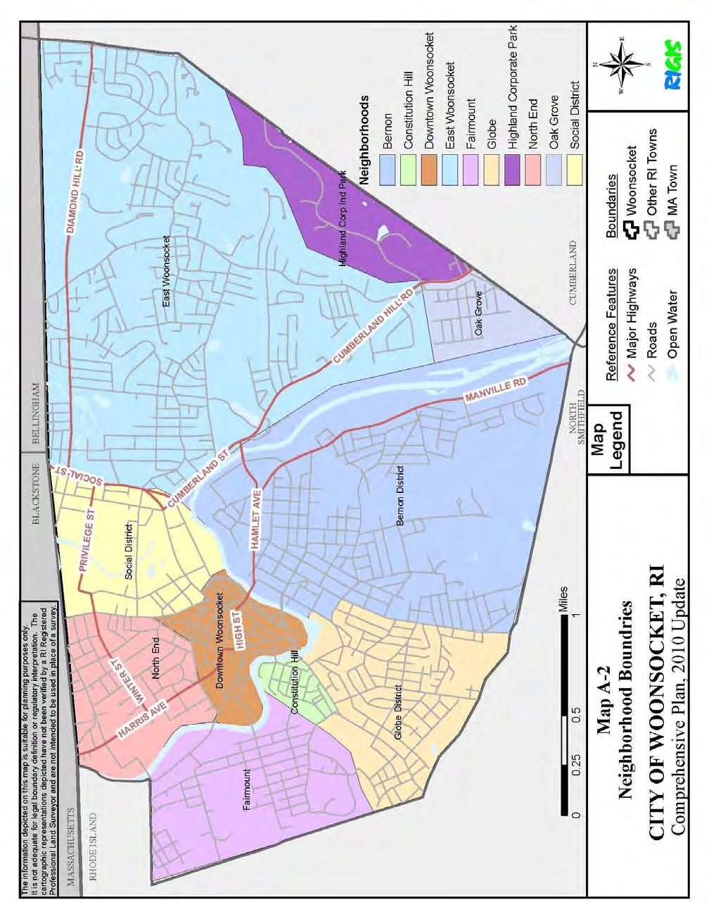
9 Introduction TABLE A-4 HISPANIC OR LATINO POPULATION: 2010 YEAR 2010 Total Population 41,186 Number % Not Hispanic or Latino population 39, Hispanic or Latino population 5, Source: U.S. Census Bureau, Census 2010 Though small in population and area, Woonsocket has the urban feel of a city where you can live, work, shop and play. There are nine distinct neighborhood districts in the City as well as a sizable industrial park, home to the headquarters of CVS-Caremark. Map A-1 shows the census tract boundaries within the city and Map A-2 shows the approximate limits of the city s neighborhoods. Woonsooocket has been in the past, and strives to be in the future, a center where its residents and those of the region can find provision for all their daily needs. A-4
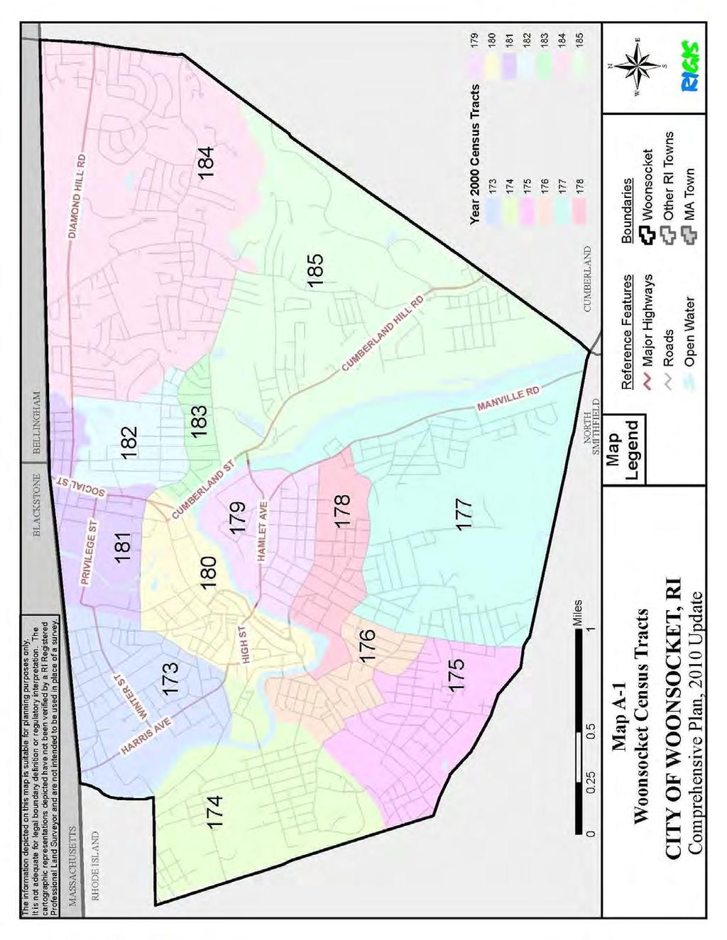
10 Introduction A-5
11 Introduction A-6
12 HERITAGE CORRIDOR ELEMENT Woonsocket Comprehensive Plan (2011 Update) Heritage Corridor The City has chosen to include this Element as a demonstration of its commitment to the successful development of the Blackstone Valley National Heritage Corridor. It consists of a set of goals which seek to both protect and enhance the significant historic, cultural and physical resources of the Heritage Corridor within the City of Woonsocket. These goals are an expression of the local community, the State of Rhode Island, and the Blackstone River Valley National Heritage Corridor Commission. CURRENT CONDITIONS AND ISSUES Blackstone River Valley National Heritage Corridor The Blackstone Valley was the birthplace of the American Industrial Revolution. The waters of the Blackstone River powered this country s first textile mills. In recognition of the historical and cultural significance of this area, in 1986 the United States Congress established the Blackstone River Valley National Heritage Corridor. The City of Woonsocket is located at the heart of this Heritage Corridor. Congress created this corridor in order to preserve and interpret for future generations the unique and significant contribution to our national heritage of certain historic and cultural lands, waterways and structures" within this area. The Blackstone River Valley is a special type of National Park; it is a living landscape that contains thousands of natural, cultural and historic treasures. In 1996 and again in 2006, Congress reauthorized the Blackstone River Valley National Heritage Corridor, assuring its presence through at least The Heritage Corridor encompasses twenty-four towns within the Blackstone River Valley and watershed from Worcester, Massachusetts to Providence, Rhode Island. It is a "unified, working landscape" tied together by the Blackstone River, the Blackstone Canal and the Providence & Worcester Railroad. Map B-1 shows the boundaries of the Blackstone River Valley National Heritage Corridor. The Valley is historically significant for many reasons. It is the birthplace of the American Industrial Revolution, influencing the rest of the country through the industrial use of water power and the development of the Rhode Island System of Manufacturing. It is an area characterized by ethnic and religious diversity. The Valley's remarkable history is revealed in its concentrations of historic, cultural, and natural resources that have survived through the past two centuries. Today, the Blackstone Valley s unique qualities remain as a result of ongoing preservation efforts that protect the Valley s special resources. The context of a working valley of mill villages, farms, cities and towns, transportation systems, river and canal is what makes the individual elements of the Blackstone River Valley significant. The Blackstone River Valley is this country's second designated National Heritage Corridor and the first bi-state National Heritage Corridor. To be a successful initiative, there needs to be strong coordination and consistency between the federal government, the States of B-1

13 Heritage Corridor Rhode Island and Massachusetts, the Heritage Corridor Commission, interested private parties, and all of the Valley s municipalities: Worcester, Leicester, Millbury, Grafton, Sutton, B-2
14 Heritage Corridor Northbridge, Upton, Hopedale, Douglas, Uxbridge, Mendon, Millville, and Blackstone, Massachusetts, and Woonsocket, North Smithfield, Cumberland, Lincoln, Central Falls, Pawtucket, Smithfield, Glocester, and Burrillville, Rhode Island. The United States Congress established a Valley-wide commission, the John H. Chafee Blackstone River Valley National Heritage Corridor Commission, which consists of local and state members nominated by the Rhode Island and Massachusetts governors and appointed by the U.S. Secretary of the Interior. The early mission of the Commission was to "assist in the development and implementation of an integrated resource management plan" for the Heritage Corridor. This resulted in the Heritage Corridor's official adoption in 1990 of its Cultural Heritage and Land Use Management Plan. This Plan identifies seven action areas for focusing its efforts in the Valley. These seven areas are coordination and consistency, historic preservation, environmental conservation, land use management, recreation, economic development, and tourism. In 1997, the Heritage Corridor Commission adopted an amendment to its Cultural Heritage and Land Management Plan, entitled The Next Ten Years. This amendment sets out four Core Commitments of the Commission s work. These four Core Commitments are 1) to tell the story of the American Industrial Revolution to a national audience and shape a visitor experience which makes this story accessible to large numbers of people; 2) to promote preservation and new life for the Valley s older village centers, mills, and other historic resources; 3) to assist local communities in balancing conservation and growth; and 4) to reaffirm an active commitment to improving the health of the river system. Within each of these seven areas and four commitments, the City of Woonsocket supports the goals of the Commission s Cultural Heritage and Land Management Plan for the Heritage Corridor. Woonsocket intends to work within the framework established by the Heritage Corridor Commission and to develop and implement its own integrated cultural, historical, and land resource management programs for the purpose of retaining, enhancing, and interpreting the significant assets of the lands, waters, and structures within the Heritage Corridor. Land Use and the Built Environment The national significance of the Blackstone River Valley rests in the sheer number and quality of the Valley s historic structures, and heritage landscapes that remain intact from the time of the Industrial Revolution and earlier. Many of Woonsocket s historic structures, its former mills and historic storefronts are concentrated in Woonsocket s central core, on the city s historic Main Street and along the banks of the Blackstone River. These historic buildings and structures are valuable resources for both the community and the greater Blackstone Valley region. Unfortunately, for several decades since the decline of the manufacturing industry, many of these historic resources sit idle or underutilized. The city s historic Main Street struggles with high vacancy rates in the commercial storefronts and has been unsuccessful at encouraging upper-floor residential uses in these buildings. Many of the former textile mills that make up the historic fabric of the Blackstone River Valley are also idle or underutilized, although others have seen substantial renovation and adaptive reuse in recent years. These structures are threatened by the risk of fire or demolition, yet fire and building code requirements have made it difficult to B-3
15 Heritage Corridor renovate and rehabilitate historical properties. Woonsocket is challenged to devise sustainable solutions to these issues in ways that preserve Woonsocket s critical historical and cultural position within the context of the larger Blackstone River Valley region. The structures built during this former era do pose unique reuse challenges because the building stock is not always easily adapted to modern-day spatial and functional needs. In order for Woonsocket to fully capitalize on its position at the center of the Blackstone River Valley National Heritage Corridor, the city must encourage appropriate preservation and adaptive reuse of its historic built environment. Woonsocket's pattern of land use has changed since the early time of industrialism. During the industrial era, the city s commercial and manufacturing land uses were concentrated in the downtown core and the riverfront area. Now these land uses are primarily located on the outskirts of the city in the Highland Corporate and Woonsocket Industrial Parks and along the major commercial artery, Diamond Hill Road. Mill complexes built along the river now present opportunities to meet such differing needs as light industry, retail, and housing. Several recent successful mill-to-condominium conversion projects in the city highlight the changing land-use patterns in the community. Transportation systems at once comprise the old patterns of land use and greatly influence their evolution. Growth necessitates the expansion and/or creation of new networks to accommodate more people and newly developed areas. A sensitive relationship clearly exists between increasing and improving transportation systems and preserving the historic, cultural and natural landscapes which contribute to the history and quality of life in the Valley. Alternative and multi-modal methods of transportation such as bus service, bike paths, commuter rail, and river travel provide opportunities in the future to better connect Woonsocket with the surrounding Blackstone Valley communities. Land use along and adjacent to the River can have a tremendous effect on the environmental and visual quality of the River, and of the Valley as a whole. A Blackstone River Overlay Zone has been enacted to better regulate the future land use in these most critical areas. This overlay zone is shown in Map B-2. The city also has a Design Review Overlay District, which regulates new commercial and mixed-use developments throughout the community. This regulatory tool can and should be used to ensure that new commercial and mixed-use developments are sensitive to the historical context of Woonsocket as a Blackstone River Valley National Heritage Corridor community. Conservation and Environmental Protection While a rich industrial heritage has left valuable resources throughout the landscape of the Valley, the nature of the manufacturing industry has also created a legacy of environmental woes. Industrial properties, particularly those along riverways, often contain toxic wastes and hazardous materials which pose serious deterrents to the reuse and development of these properties. Woonsocket has inherited a significant inventory of lands and buildings which are wholly or partially unusable due to this problem. The following Plan Element, Natural and Cultural Resources, discusses the brownfields situation in Woonsocket in greater detail. B-4

16 Heritage Corridor B-5
17 Heritage Corridor In a recent public survey, undertaken as part of this Comprehensive Plan Update, community members voiced clear and strong support for protecting the Blackstone and its tributaries, the Mill and Peters Rivers, as the primary natural resource in the Blackstone Valley. As Woonsocket turns to its rivers and riverbanks as rediscovered community resources, a comprehensive approach is needed to reclaim these important lands and waters. The related issues of public ownership of the riverbanks, increased public access to rivers, improved water quality, expansion of water-related recreational activities, and preservation and interpretation of historic resources associated with these rivers must be the focus of policy guidelines for the city, state, and Blackstone Valley region. Regional Planning and Cooperation The existence of the Blackstone River Valley National Heritage Corridor Commission has helped strengthen the identity of the Blackstone Valley as a regional entity with a common heritage and a common resource: the Blackstone River. With a number of Valley-wide projects underway, there is a sense among communities that the Valley as a whole is greater than the sum of its parts. Recent developments within the Heritage Corridor include the ongoing bi-state Blackstone River Bikeway project, a Blackstone Valley commuter rail initiative, heritage festivals throughout the region, increased canoe and kayak access points into the Blackstone River, and public park and conservation land development adjacent to the Blackstone River, among other regional projects create opportunities to improve the quality of life for Woonsocket residents to draw new populations and visitors to the city and the region. Woonsocket has made strides towards becoming more of a tourist destination. The city is actively involved in efforts to capitalize on the recreational amenities and heritage tourism potential of Woonsocket s part of the Blackstone River Valley. In conjunction with the Heritage Corridor Commission and the Blackstone Valley Tourism Council, Woonsocket plays host to a variety of events including kayak races, heritage festivals, and concerts at its downtown riverfront park, River Island Park. The City also partners with these and other regional entities in support of the Blackstone River Bikeway project, the Blackstone Valley commuter rail initiative, and the River s Edge Recreational Complex project. Both the Bikeway project and the River s Edge Recreational Complex support the Heritage Corridor Commission s mission to develop park space along the Blackstone River and to increase public access to the Blackstone River. Woonsocket s new middle school campus, with its public athletic fields, has been constructed alongside the Blackstone River, providing additional riverside acreage to the public. The Blackstone River Bikeway and the River s Edge Recreational Complex projects are discussed in greater detail in the Open Space and Recreation Element. The Blackstone Valley commuter rail initiative project is discussed in greater detail in the Circulation Element. The completion and opening of the Museum of Work and Culture at the former Lincoln Textile Complex site in downtown Woonsocket is the centerpiece of the city s efforts to showcase its historical and cultural significance within the Valley. This interactive museum presents the compelling story of the French Canadians who left the farms of Quebec for the factories of the New England area. It tells the remarkable story of a people's preservation of their faith, language, and customs and their acculturation into the working class of America. The museum's exhibits B-6
18 Heritage Corridor recreate the unique Woonsocket experience while also telling a broader story of hope, struggle and perseverance. The Museum of Work and Culture plays a central role in the heritage tourism economy of the Blackstone Valley and secures Woonsocket's prominent place in the Valley. The Museum also serves as a downtown Visitor Center and plays a key role in the rehabilitation of Main Street and Woonsocket's downtown. Furthermore, the Museum at the Visitor Center contributes significantly to the cultural life of the City and serves as a point of community pride. NEW INITIATIVES Blackstone River Bikeway The City of Woonsocket actively supports the ongoing efforts to complete the Blackstone River Bikeway project. This bikeway, once completed, will extend forty-eight miles from Providence, Rhode Island to Worcester, Massachusetts and will connect the region with other statewide bikeways, such as the East Bay Bikeway. Currently, just over 10 miles of the Blackstone River Bikeway are open to the public in Rhode Island, spanning through Central Falls, Lincoln, Cumberland, and Woonsocket. In Woonsocket, the bikeway ends at the entrance to the River s Edge Recreation Complex at Davison Avenue. The next planned segment will extend the bikeway into downtown Woonsocket and through to the North Smithfield border. In the State of Massachusetts, 2.5 miles of bikeway are complete in Worcester and Millbury. When completed, the bike path project will result in a mostly off-road alternative transportation facility passing through the historic John H. Chafee Blackstone River Valley National Heritage Corridor. The Blackstone River Bikeway will serve as an alternate mode of transportation for commuters as well as the region's premiere multi-use recreational facility. This bi-state linear State Park along the Blackstone River will connect New England's second and third largest cities and serve a population of more than 1 million. The bikeway will link many of the Valley's significant natural and historic features. The bikeway is being developed thanks largely to federal transportation funding. The cooperative efforts of the Rhode Island Department of Environmental Management, Massachusetts Department of Conservation and Recreation, Massachusetts Highway Department, and the Rhode Island Department of Transportation with support from Valley communities, are making the bikeway a reality. Map B-3 shows the entire stretch of the Blackstone River Bikeway, both existing and future sections. Commuter Rail Woonsocket supports the resumption of commuter rail service within the Blackstone Valley. From 1847 until 1960, Woonsocket residents could board trains at the Woonsocket Depot on Main Street and travel to Providence or Worcester along the Providence & Worcester Railroad. The growing trend towards alternative and intermodal modes of transportation, B-7

19 Heritage Corridor B-8
20 Heritage Corridor increased awareness of the value of mass transit, and a rising interest in rail transportation within the state and the region have inspired the city to examine whether the resumption of passenger commuter rail service within the Blackstone Valley along the Providence & Worcester Rail Road is feasible. The City completed two commuter rail studies with grant funding from the RI Statewide Planning Program s Challenge Grant Program. The first study, completed in 2007 and entitled: A Commuter Rail Feasibility Study for Woonsocket, Rhode Island, examined the city s commuter rail potential, broadly, and determined that commuter rail service from Woonsocket to Providence, along the existing P&W rail line was feasible. A second study, completed in 2009 and entitled: Intrastate Commuter Rail: Woonsocket to Warwick, examined in greater depth a future passenger rail service along the P&W line with continued service to the T.F. Green airport in Warwick. This study concluded that commuter rail service through the southern section of the Blackstone Valley from Woonsocket to Providence (and on to Warwick) was a feasible and competitive project, one that should be prioritized as the State s next rail project. It is hoped that once this service was realized, the next logical piece would be to examine extending the commuter rail service northward to Worcester, Massachusetts, thereby connecting the entire Blackstone Valley via rail. Woonsocket will continue to advocate for the creation of commuter rail service connecting Woonsocket with Providence, Warwick, and eventually, Worcester. Regional Planning in the Blackstone Valley The communities in the Blackstone Valley have been linked, physically, economically, and culturally since the time of the Industrial Revolution. These communities share a common heritage, a unique history, and a valuable natural resource: the Blackstone River. The Blackstone River Valley is now a recognizable region within the state. The Valley is recognized for its unique mixture of urban centers, mill villages, and farm towns and for its strong sense of history. Woonsocket benefits from being part of this larger region and the city plays a key role in the identity that is the Blackstone Valley. Retaining the special assets and characteristics that make the Valley what it is and strengthening Woonsocket s identity as a Blackstone Valley community will be critical goals into the future. The strength of the Valley communities is derived from their shared experiences and histories. In order to retain the historical and cultural identity of the Blackstone River Valley, a greater emphasis on regional planning will be critical. In response to this need for a more regional planning approach, the former Blackstone Valley Partnership was developed to address regional issues in the Valley such as water, economic competitiveness, land use, and transportation and to build greater regional cooperation around strategic projects. While the Blackstone Valley Partnership does not currently exist, there is hope to reinstate this network of regional stakeholders whose mission was to strengthen and unite the communities of the Valley through a regional approach to planning, transportation, and land use. Woonsocket is committed to actively engaging in a regional planning process for the Blackstone Valley because strengthening the Valley as a whole strengthens Woonsocket. The City has a goal of strengthening its identity as a Blackstone Valley community through affiliation with this group. B-9
21 Heritage Corridor GOALS AND POLICIES The following goals and policies have been developed to guide the protection and enhancement of the Blackstone Valley National Heritage Corridor: GOAL HC-1 The City s historical, cultural, and natural resources are protected and preserved in an integrated manner. POLICY HC-1.1 Protect the Blackstone River and its tributaries as the primary natural resource in the Blackstone Valley. (also see POLICY NCR-2.1c on page E-47) IMPLEMENTATION HC-1.1a Form alliances between government, local businesses, landowners, regional foundations, and environmental advocacy groups such as the Trust for Public Land and the Nature Conservancy to ensure that key natural resources are protected. IMPLEMENTATION HC-1.1b Increase public awareness and appreciation of natural resources by supporting public education and outreach on environmental issues in the community. IMPLEMENTATION HC-1.1c Advocate with surrounding communities, the EPA and RIDEM for a collaborative, regional, watershed-based approach to hazardous waste cleanups and brownfields remediation. IMPLEMENTATION HC-1.1d Explore tax incentives, including deferment, for businesses instituting stricter pollution controls. POLICY HC-1.2 Preserve Woonsocket s significant historic structures as valuable heritage resources in the Blackstone Valley. IMPLEMENTATION HC-1.2a Pursue technical assistance and funding to continuously update and evaluate the Statewide Historical Preservation Report. IMPLEMENTATION HC-1.2b Collaborate with the public to gather public support for a local Historic Districts Commission. IMPLEMENTATION HC-1.2c Identify and establish additional local historic districts under the authority of a local Historic Districts Commission. B-10
22 Heritage Corridor IMPLEMENTATION HC-1.2d Support and encourage applications of National Register nominations and, once applicable, local historic zoning proposals. IMPLEMENTATION HC-1.2e Identify historic properties that are threatened by development pressures, deterioration or inadequate resources, and take proactive steps to prevent the loss of these resources. GOAL HC-2 Woonsocket maintains its Blackstone Valley character through an integrated approach to land use management. POLICY HC-2.1 Protect key historic, cultural and natural resources utilizing zoning regulations and incentives as tools. IMPLEMENTATION HC-2.1a Ensure that all new developments within the River Corridor Overlay District are reviewed by the River Corridor Commission. IMPLEMENTATION HC-2.1b Develop design guidelines for the Design Review Overlay District in accordance with the Heritage Corridor s Design Review Manual. POLICY HC-2.2 Require land use near rivers, streams, wetlands, and restrictive soil areas to be environmentally sensitive. IMPLEMENTATION HC-2.2a Require that low-impact development measures are implemented in new subdivisions and in sensitive environmental area. POLICY HC-2.3 Develop and maintain conservation areas and parkland along the Blackstone River and its tributaries, consistent with Heritage Corridor goals. IMPLEMENTATION HC-2.3a Rehabilitate and maintain the City s existing riverfront parks, including River Island Park, River s Edge, Cold Spring Park, and Costa Park. IMPLEMENTATION HC-2.3b Identify and protect land suitable for conservation along the Blackstone River and its tributaries. B-11
23 Heritage Corridor POLICY HC-2.4 Support economic development projects and initiatives that complement the unique character of the Blackstone Valley. IMPLEMENTATION HC-2.4a Help thriving established local manufacturers, mature industries and businesses to maintain their utilization of old structures. IMPLEMENTATION HC-2.4b Establish grant/loan programs for the internal adaptation of older, historic mill buildings and structures to meet industrial needs. IMPLEMENTATION HC-2.4c The Design Review Commission s review of new and expanded commercial and mixed-use developments encourages the design of these developments to be sensitive to the historical design context of Woonsocket. POLICY HC-2.5 Take a pro-active role in local transportation and RIDOT projects to ensure the consideration of historic, cultural and natural features in the design process. IMPLEMENTATION HC-2.5a Establish a City liaison to actively review proposed plans and communicate with RIDOT during the design development stage of transportation projects. GOAL HC-3 Woonsocket is fully integrated into and identified as a critical part of the broader Blackstone Valley region. POLICY HC-3.1 Interpret the Valley's importance and sponsor activities which lead to public education and engagement about Woonsocket s and the Valley s local historic, cultural, and natural resources and their proper use. IMPLEMENTATION HC-3.1a Incorporate interpretive features of historic information into public projects when appropriate, with the assistance of the Woonsocket Historical Society and the Heritage Corridor Commission. IMPLEMENTATION HC-3.1b Develop an interpretive education curriculum for grades K-12 involving the School Department, the Conservation Commission, the Historical Society and other key partners. B-12
24 Heritage Corridor POLICY HC-3.2 Pursue and support local projects that support the broader goals of the Heritage Corridor. IMPLEMENTATION HC-3.2a Research opportunities and apply for grant funds from the Heritage Corridor Commission and other agencies to fund heritage corridor-related local projects. POLICY HC-3.3 Expand heritage tourism opportunities as a means of preserving Woonsocket s heritage resources and as a sustainable economic development tool. IMPLEMENTATION HC-3.3a Continue to support the Woonsocket Visitor Center / Museum of Work and Culture. IMPLEMENTATION HC-3.3b Develop a realistic, short-term tourism plan based on a Valley-wide strategy that identifies the key features with tourism potential in Woonsocket that could be tied into a larger series of tourism activities. IMPLEMENTATION HC-3.3c Develop and disseminate a Woonsocket tourism map with identified Valley-wide and regional tourism sites. IMPLEMENTATION HC-3.3d Advocate at the State level for the continued presence of the Blackstone Valley in the tourism plans for Rhode Island. IMPLEMENTATION HC-3.3e Utilize the Blackstone Valley Council's Tourism Plan and the Heritage Corridor Commission s plans as a basis for developing appropriate local tourism strategies and programs. IMPLEMENTATION HC-3.3f Collaborate with the Blackstone Valley Tourism Council and the Heritage Corridor Commission for special events promotion, and encourage the continuation of activities such as the Autumn Foliage Train, the Autumnfest, the Dynamite Cook-off, the French Farmer s Market, the Polar Express, the Blackstone Valley Explorer boat tours, and the Greenway Challenge. GOAL HC-4 Woonsocket is an active supporter of and participant in regional planning efforts within the Blackstone Valley which link the Valley s resources and communities together. POLICY HC-4.1 Encourage cooperation and consistency with other local communities in planning efforts. B-13
25 Heritage Corridor IMPLEMENTATION HC-4.1a Utilize the Blackstone Valley Partnership as a forum for achieving regional-level planning in the Valley. POLICY HC-4.2 Actively engage in Valley-wide partnership projects and initiatives which are consistent with the goals of the Heritage Corridor. IMPLEMENTATION HC-4.2a Attend the regular meetings and events of the Heritage Corridor Commission, the Blackstone Valley Tourism Council, Main Street Riverfront Initiative Group, and other similar groups. IMPLEMENTATION HC-4.2b Actively pursue commuter rail service in the Blackstone Valley by working with local, state, and federal partners to obtain funding for additional study, design, and construction. POLICY HC-4.3 Encourage recreation development and programs which emphasize Valley resources and provide links to other communities. IMPLEMENTATION HC-4.3a Support the Bikeway as an alternative transportation route and recreational and educational feature. IMPLEMENTATION HC-4.3b Establish a reporting schedule with RIDOT and RIDEM on Bikeway progress. IMPLEMENTATION HC-4.3c Work with RIDOT and RIDEM to examine access to the Bikeway from key areas off-site, and to ensure compatibility with existing street traffic in the design development of the Bikeway. IMPLEMENTATION HC-4.3d Collaborate with and support the Heritage Corridor Commission in the establishment of a greenway along the Blackstone and Mill Rivers. B-14
26 Housing HOUSING ELEMENT Shall consist of identification and analysis of existing and forecasted housing needs and objectives including programs for the preservation, improvement and development of housing for all citizens. The housing element shall enumerate local policies and implementation techniques to provide a balance of housing choices, recognizing local, regional and statewide needs for all income levels and for all age groups, including but not limited to, the affordability of housing and the preservation of federally insured or assisted housing. The element shall identify specific programs and policies for inclusion in the implementation program, necessary to accomplish this purpose. (Rhode Island Comprehensive Planning and Land Use Act ) CURRENT CONDITIONS AND ISSUES Introduction Woonsocket has long been home to numerous manufacturing businesses and as a direct result has been populated by a high percentage of hard-working blue-collar workers. The tremendous expansion of the local economy resulting from the industrial revolution in the late 19th and early 20th centuries was the catalyst of Woonsocket's urbanization and development. This development was marked by the construction of modest multi-story wood frame tenements, in a high density configuration, in the Social, Globe, Lower Bernon, Constitution Hill and Fairmount neighborhoods. Large single-family homes for the affluent business owners were constructed in the City's North End. The environment shaped and built during this period is in large part the same one that exists today in many inner-city neighborhoods. Since the 1950 s, housing construction in the outlying neighborhoods, while decreasing the amount of undeveloped land in the City, has provided a broader range of housing options for Woonsocket's residents. Analysis of Past Housing Initiatives by the City of Woonsocket and Surrounding Communities At the conclusion of World War II, Woonsocket made a substantial commitment to provide family housing for its low and very low income residents. With direct federal financial assistance, sizeable public family housing developments were constructed at Morin Heights and Bourdon Boulevard. This housing has been well-maintained over the years, being periodically renovated by the Woonsocket Housing Authority. Today, it continues to provide quality public housing units to the area's neediest families. When combined with other federal low-income housing programs such as Section 8 and RI Housing s affordable housing stock in the city, there are over 1,600 affordable housing units for families in Woonsocket. In addition, there are over 1,500 public housing, RI Housing, Section 8, HUD 202, and group home housing units in the city for the area's elderly and disabled residents. The majority of these units have been constructed in the form of large high-rise structures in and adjacent to the downtown area. As of 2006, the City of Woonsocket had over 3,000 housing units available for the city s low-income family, elderly, and disabled residents. Table C-1 shows a breakdown of these housing units by type. As Table C-1 illustrates, Woonsocket hosts over 1,600 units of public and subsidized family units. Table C-2 lists the type and location of the city s public subsidized housing units. C-1
27 Housing Location TABLE C-1: ASSISTED HOUSING BY CITY AND TOWN Elderly RIH Public HUD HUD 202 Rural Housing Section 8 Housing Service 515 Elderly Total Burrillville Cumberland Lincoln North Smithfield Woonsocket ,298 Regional Totals 1,130 1, ,701 Providence 2,089 1, ,348 Pawtucket ,351 Central Falls Location Family RIH Public Housing HUD Section 8 Rural Housing Service 515 Other- Family Family Total Burrillville Cumberland Lincoln North Smithfield Woonsocket ,632 Regional Totals ,121 Providence 1,885 1, ,580 Pawtucket ,126 Central Falls Location Special Needs Group Transitional Units PSH* HUD 811 Home Beds Special Needs Total Burrillville Cumberland Lincoln No. Smithfield Woonsocket Regional Totals Providence Pawtucket Central Falls C-2
28 Housing Location LMIH Grand Total 2010 Census: Total Housing Units** 2009 Overall LMIH % Burrillville 500 6, % Cumberland , % Lincoln 595 9, % No. Smithfield 381 5, % Woonsocket 3,080 19, % Regional Totals 5,302 53, % Providence 10,079 71, % Pawtucket 2,722 32, % Central Falls 862 7, % Source: RI Housing (Updated April 2010) * Permanent Supportive Housing ** Total Housing Units less seasonal units Housing Type TABLE C-2: LOW AND MODERATE INCOME HOUSING BY TYPE Name of Location Program Type Rental/ Development Homeownership Total Number of Units Blackstone Elderly Apartments 23 Clinton St. RIH Elderly Rental 47 Chateau Clare 16 Greene St. HUD Section 8 -Elderly Rental 87 Crepeau Court 100 Front St. Public Housing - Elderly Rental 153 Fairmount Heights 525 2nd Ave. RIH Elderly Rental 138 Hanora-Lippett Mills 1 Main St. RIH Elderly Rental 117 John F. Kennedy Manor 547 Clinton St. Public Housing - Elderly Rental 198 Park View Manor 218 Pond St. Public Housing - Elderly Rental 150 Sadwin Apartments 183 Elm St. HUD 202 Rental 33 St. Germain Manor 429 East School St. Public Housing - Elderly Rental 153 Sutherland 462 East School Apartments St. HUD 202 Rental 10 Veterans Memorial 2 Bourdon Blvd. Public Housing - Elderly Rental 12 Waterview Apartments 300 Privilege St. RIH Elderly Rental 100 Temple Mount Vernon 939 Bernon St. RIH Elderly Rental 100 Family Ashley Court West St. RIH Family Rental 22 Burnside Apartments 96 Burnside Ave. RIH Family Rental 11 BVCAP 1044 Social St. RIH Family Homeownership 6 Constitution Hill I 103 Olo St. RIH Family Rental 44 Constitution Hill II & III 141 Olo St. RIH Family Rental 47 Constitution Hill IV 143 South St. RIH Family Rental 19 David Housing 459 Front St. HUD Section 8 - Family Rental 21 Erik Estates Elm St. RIH Family Rental 16 C-3
29 Housing Special Needs Glenark Landing 104 Sayles Ave. RIH Family Rental 67 Morin Heights 66 Morin St. Public Housing - Family Rental 298 Pothier Condos 1044 Social St. RIH Family Homeownership 6 Plaza Village 180 Village Rd. HUD Section 8 - Family Rental 228 Rock Ridge 181 Rock Ridge Apartments Rd. RIH Family Rental 114 St. Ann's Apartments Gaulin Ave. RIH Family Rental 25 Veterans Memorial 2 Bourdon Blvd. Public Housing - Family Rental 276 Village West 128 Cumberland St. RIH Family Rental 35 Vulcan Apartments 32 North East St. HUD Section 8 - Family Rental 41 Walnut Hill 2085 Diamond Apartments Hill Rd. HUD Section 8 - Family Rental 125 Woonsocket NDC 193 Rhodes Ave. RIH Family Homeownership 6 Woonsocket NDC 33 Snow St. RIH Family Homeownership 1 Woonsocket NDC 43 Snow St. RIH Family Homeownership 3 Woonsocket NDC 24 New St. RIH Family Homeownership 1 Woonsocket NDC 10 6th Ave. RIH Family Homeownership 3 Woonsocket NDC 1 Marian Ln. RIH Family Rental 9 Woonsocket NDC 146 Sayles St. RIH Family Rental 1 Woonsocket NDC 719 Front St. RIH Family Rental 43 Woonsocket PHA 44 Jacob Ln. Public Housing - Family Rental 51 Woonsocket Village 182 Cumberland St. RIH Family Rental 89 Temple Mount 98 Rivulet St. Vernon RIH Family Rental 24 Leo M. Tanguay 129 Main St. Apts. HUD 811 Rental 8 Roland Boucher 30 Willow St. Apts. HUD 811 Rental 31 Willow House 444 Willow St. HUD 811 Rental 10 Woonsocket Shelter 184 Sayles St. Transitional Units Rental 16 Group Home Beds -- Group Home Beds Source: RI Housing (April 2008) In October 2009, the Woonsocket Housing Authority (WHA) submitted a request to HUD for approval to demolition some of these public housing units. If HUD approves this request, these unit counts will be reduced. In summary, based upon the 2010 statistics developed by RI Housing and the State of Rhode Island, 16.03% of the housing units in the City of Woonsocket are classified as affordable to low-moderate income households. Woonsocket fully supports the State of Rhode Island s mandate that all communities work to reach and exceed the state-mandated 10% housing affordability. The conclusion can be drawn, that through the years, Woonsocket's commitment to provide low and very low income housing for area residents has substantially surpassed that of the State's comparable older urban areas. In Woonsocket, the total number of assisted units has continued to grow during a period of continued overall population decline. In order to achieve the central and priority goals of the Comprehensive Plan, Woonsocket should selectively choose those programs which will not only be a benefit to the continued housing needs of its residents, but help achieve its important C-4
30 Housing community development goals, which are centered around the provision of low-income homeownership opportunities and achieving a healthier balance between the city s rental and homeownership housing stock. The City of Woonsocket has developed a homeownership strategy that involves preserving existing homeownership while increasing opportunities for low and moderate income households to become homeowners. This program should include a comprehensive homebuyer education program. The City of Woonsocket has developed the Woonsocket Healthy Homes Programs. The programs involve preserving existing homeownership, creating safe and healthy homes, and increasing homeownership opportunities for low to moderate income households. The repair cost assistance can cover lead hazard reduction and code-related repairs. The funds are distributed in the form of a deferred loan and a forgivable loan. Homebuyer Assistance Down payment and other repair cost assistance is available to lowmoderate income first-time homebuyers purchasing a home as their principal residence. Home Repair Cost Assistance Repair funds for single family homeowners and landlords of affordable rental properties. The Woonsocket Housing Authority (WHA) is the agency responsible for the operation of public housing units in the City. WHA owns and operates 1,291 units of public housing and 502 Section 8 subsidies. These units are a valuable source of affordable housing for Woonsocket s low and very low income households. Over the years, WHA has begun providing a number of services to their residents. They have implemented family self sufficiency, homeownership, educational, and job training programs for family residents and health services and recreational programs for elderly and disabled residents. WHA s Comprehensive Plan lists detailed plans to comply with handicapped accessibility codes, lead based paint testing and other issues. NeighborWorks Blackstone Valley (formerly the Woonsocket Neighborhood Development Corporation) is a non-profit entity which has made significant contributions to the revitalization of the City s affordable housing stock. In recent years, NeighborWorks efforts in the Constitution Hill and Fairmount neighborhoods have resulted in neighborhood revitalization in a neighborhood that had experienced significant disinvestment in its housing stock. NeighborWorks has rehabilitated many multi-family structures in the neighborhood, providing affordable rental units while reversing the neighborhood s visual blight. In addition, NeighborWorks offers several social service programs for area residents which comprehensively address the needs of low and moderate income households in the area. Sojourner House and Family Resources are two agencies which are addressing the needs of the homeless in Woonsocket. Homeless shelters and other special needs housing are discussed in more detail in the Significant Issues section of this element C-5
31 Analysis of Housing Supply and Demand Woonsocket Comprehensive Plan (2011 Update) Housing Demand An analysis of the demand side of Woonsocket's housing market requires an analysis of the City's population and household characteristics. Woonsocket has experienced absolute population declines over the past fifty years, but their impact has been blunted by an increase in the number of households residing in the City. This difference is due to the decreasing number of people per household in the City. The City s disproportionately high percentage of elderly residents tends to live alone more often than younger adults. This trend reflects a broader nationwide trend of shrinking household sizes. In 2010, 81% of all households had between 1 and 4 members, while 57% had 1 or 2 members. Woonsocket's median age is 36.8 years, which is lower than the State s corresponding figure (39.4). Yet, the percentage of those in the 65 years and older category in Woonsocket (13.2%) is similar to the State s percentage (14.4%). A large number of elderly residents reside in the Woonsocket Housing Authority s elderly developments (JFK Manor, St. Germaine Manor, Parkview, and Crepeau Court, as well as other affordable elderly rental developments and nursing homes). The trend of elderly homeowners staying in their homes longer contributes to fewer units becoming available for younger buyers or new residents to the community. Woonsocket s large percentage of elderly homeowners impacts the community through tax abatements to the elderly which reduce the City s revenue. Upwardly mobile and higher income Woonsocket residents have continued to leave the City, not only for lack of quality educational programs, job opportunities and other amenities (real or perceived), but due to the limited availability of quality higher priced housing units. The trend of higher priced housing units catering to Boston area commuters, that has been seen in nearby communities such as Wrentham, Franklin, and Cumberland has not significantly affected Woonsocket to date. The lack of significant amounts of undeveloped land free of significant constraints causes potential real estate developers to look to surrounding suburban communities. In general, Woonsocket is considered to be quite land poor. Some undeveloped residential land does exist, however, and should be developed with respect for its natural constraints, and compatibility with surrounding neighborhoods. Out of approximately 2,800 acres of residential land in the City, approximately 250 acres (9%) are undeveloped. Of the undeveloped residential land, approximately 90 acres are developable based on having frontage on an accepted public street. Woonsocket's minority population has increased significantly during the past decade from 7% in 1990 to nearly 20% in 2000 to 22.3% in A large percentage of this increase is from groups whose first language may not be English, particularly Asians and Hispanics. Table C-3 shows the change in race by household between 1990 and 2000 to 2010, according the US Census. C-6
32 Housing TABLE C-3: RACE BY HOUSEHOLD, % % 2010 Change Change Number % Number % Number % Total Households 17, , , Total Minority Households 1, , , Asian Black American Indian/Alaska Native Native Hawaiian/Pacific Islander** Other Hispanic Origin* , , White (Not Hispanic) 16, , , Two or More Races** * Persons of Hispanic origin may be of any race. ** This group was not categorized until Source: U.S. Census 1990, 2000 and 2010 Woonsocket's household median income according to the American Community Survey Estimates was $41,001, which trails that of the region and the State. In 2009 it was only 73.8% of the statewide median, which in 2009 was $55,569. This income statistic is partially offset by the pricing of comparable housing in Woonsocket being below other Rhode Island communities. For instance, in 2008, the median selling price for a single-family home in Woonsocket was $180,000 as compared to $234,000 median for the State as a whole. According to U.S. Department of Housing and Urban Development guidelines, 64% of all persons in the City qualify under the definition of low/moderate income. Neighborhood stability is one indicator a neighborhood s quality of life. As of 2010, 69% of all City households have lived in the same housing unit for at least five years. This percentage increased from 47% in Stability is so important to a neighborhood and community. Owner occupancy is, of course, correlated to neighborhood stability, as owners are less likely to move, and are more likely than owners who live elsewhere to invest in their property. There is a high demand for special needs housing in the City and the surrounding communities. As indicated by local service providers and as a result of the economic recession of 2008/2009, Woonsocket, like most urban areas, has recently experienced a worrisome increase in homelessness over the past years. Supply In 2009, the value of the City's housing resources is $1.27 billion dollars. This represents the largest single component of the local economy and tax base. Housing is also one of the costliest day-to-day living expenses incurred by many City households. (See section on demand/supply interrelation for information on the rent burdened population). C-7
33 Housing Woonsocket's housing supply has steadily increased over time, but despite this growth, the City has an older housing stock. Sixty-two percent (62%) of the City s housing stock was built before Table C-4 shows the year built for the City s housing stock from pre-1939 to TABLE C-4: YEAR STRUCTURE BUILT, 2009 Total Housing Units (%): 18,683 (100.0) Built 2005 or later 252 (1.3) Built 2000 to (2.3) Built 1990 to (2.9) Built 1980 to (3.8) Built 1970 to ,321 (7.1) Built 1960 to ,797 (9.6) Built 1950 to ,012 (10.8) Built 1940 to ,026 (5.5) Built 1939 or earlier 10,588 (56.7) Source: American Community Survey Estimates As would be expected, areas of the City with a greater percentage of older units are generally found closer to the City s core. An exception is block group which encompasses the Social Renewal Area adjacent to downtown, where few older dwelling units remain after the mass demolition during the 1970 s. Younger dwelling units are generally found in East Woonsocket, and in the area surrounding Jillson Avenue. Woonsocket contains the third highest percentage of renter occupied housing units in the State, trailing only Providence and Central Falls. Sixty-five percent of all occupied dwelling units in the City are renter occupied and thirty-five percent of all occupied units are owner occupied. Map C-1 shows the percent of renter occupied housing units by census block for As the figure shows, a greater percentage of rental units are found in the City s central core areas. Approximately 45% of the City's dwelling units are in multi-family structures with between 3 and 9 units. Just over 27% of the housing supply is made up of single-family housing units. An additional 13% of the housing stock is comprised of two-family homes. Woonsocket has a much higher percentage of multifamily dwelling units than does the rest of the State. Over 73% of the City s housing units are in units other than single-family homes, as compared to only 45% Statewide. The variation in the number of rooms per unit is fairly limited in the City. A little less than half of the housing stock (48%) is composed of 4 or 5 room units, best suited for small or medium sized families. Woonsocket lacks many of the large single family homes that are increasingly popular among families today. There has been very slight increase in units with 1 to 3 rooms, and this is almost entirely due to new additions in the City s housing stock including a significant number of government assisted elderly housing complexes. When coupled with the age of the majority of the City s housing, renovation is a significant concern. Since 62% of all units were built before 1950, a great deal of the City s housing stock will be affected if renovations are not made. Lack of renovations will lead to C-8
34 Housing vacancies, demolition, and increased economic segregation in the City s older multifamily neighborhoods, as older tenements become desirable only to the lowest income residents. One hindrance to multi-family and commercial property owners completing renovations is the hardship imposed by fire code changes. Renovation is also a major concern due to the threat of lead poisoning in the City. Lead poisoning is an issue which directly relates the City s housing stock with the health of its children. Over recent years, Woonsocket has seen a significant reduction in incidents of lead poisoning in its children. According to the 2009 Rhode Island Kids Count Factbook, the percentage of lead poisoning in kindergarten-aged children is 3.0%, which is slightly lower than the State average of 3.1% and is significantly lower than the 5.2% rate of lead poisoning found in other Rhode Island core cities. While any amount of lead poisoning in children is unacceptable, it is encouraging that Woonsocket, especially given the age of its housing stock, has succeeded in reducing the incidents of childhood lead poisoning. Most of this success is attributable to education and outreach, which are critical components to an effective lead hazard program. However, in order to completely eliminate incidents of lead poisoning, the City must continue with its lead abatement assistance programs to homeowners. According to the 2009 American Community Survey Estimates, approximately 90% of Woonsocket s housing stock was built before 1980, making them likely to contain lead-based paint. Demand and Supply Interrelationships The interrelationship between demand and supply gives rise to the problems and opportunities facing the citizens and policy makers of Woonsocket in the coming years. Some of the indicators of the success or failures of the local housing market are summarized below: Vacancy rates have increased over recent years. Earlier Census data ( ) showed vacancy rates ranging from 4% to 5.6%. In 1990, there was a City vacancy rate of 7.4%. By the 2000 Census, this dropped to 5.4%, but increased to 11.2% in Anecdotal information, analysis of the increasing number of rental ads in the Woonsocket Call and other information indicate that the current number of vacant units may be even higher. This rate substantially exceeds the widely recognized desired vacancy rate of %. C-9

35 Housing C-10
36 Housing The current rate has placed many multi-family housing structures at financial risk. Map C-2 shows the percent of vacant housing units by census block as of Figures from the 2000 Census for Tenure by Occupants per Room provide an index of the fit of a household to its housing accommodation, an indication of the adequacy of the supply as compared to the physical needs of households. Since 1960, Woonsocket s Tenure by Occupants per Room has been steadily declining to 2000 levels where 97% of the City s households occupied quarters with no more than 1 person per room (the Census Bureau s definition of overcrowding ). In large part, this was due to increasing numbers of smaller households. While it is true that overcrowding is not a significant problem in the City, Woonsocket is nonetheless characterized by some of the highest population densities in the State. Table C-5 lists the people per square mile by Woonsocket Census Tracts. Census Tract TABLE C-5 POPULATION DENSITY BY CENSUS TRACT, Square Mileage 2000 Population Density (per./sq.mi.) 2010 Population Density (per./sq.mi.) % Change , , , , , , , , , , , , , , , , , , , , , , , , , , Citywide , Notes: 27,878,400 sq.ft in a sq.mi. There are significant variations of income capacities and housing costs across the City s neighborhoods. Yet despite the costs involved, owning a home remains an important aspiration for many residents. Woonsocket has a history of being one of the more affordable communities in Rhode Island for both rental and homeownership. For example, according to Census 2000, the median family income in Woonsocket in 1999 was $38,353. In 1999, the median selling price of a single-family home in Woonsocket was $105,000 with a typical monthly housing payment of $805 (calculated based on Housing Works RI s housing cost formula.) In 1999, this was only 25% of the median household family income and considered quite affordable. Affordability is typically defined as paying less than 30% of the household income on housing costs. However, from 1999 to 2008, the average selling price of a single-family home in Woonsocket rose 71% to $180,000. While this is still significantly more affordable than the State median of $234,000, it is nearly certain that Woonsocket s median family income has not risen to keep pace with the rising C-11
37 Housing cost of homeownership. In Woonsocket, the median family income is 68% of the income needed to afford the average purchase price of a home. This compares favorably with the 60% ratio for the State of Rhode Island. Renters are devoting greater portions of their income for housing. A rent burdened household, as defined by HUD, is one which spends over 30% of its income on rent. HUD defines households which spend over 50% of their income of rent to be severely rent burdened. % of Income Spent on Gross Rent TABLE C-6: GROSS RENT AS A PERCENTAGE OF INCOME: Number % of Number % of % Number Total Total Change 4, , ,346 % of Total % Change 37.1 Less than 20 % to 24 % 1, , , to 29 % 1, , , to 34 % , % or more 2, , , **35 to 39 % to 49 % % or 1, more Total Rental Occupied Units* 10, , , * 1990 and 2000 totals do not include households that were "Not Computed" per the census data table. ** Census 2000 data includes greater delineation than previous reports. Source: U.S. Census 1980 & 1990; Census 2000, Summary File 3 (SF 3), H69 -Gross Rent as a Percentage of Household Income C-12

38 Housing C-13
39 Housing According to the 2000 Census, and as shown in Table C-6, in 2000, 33% of the City s renters paid 30% or more of their income for rent, up from 28% in In 2000, 17% of City renters were considered severely rent burdened. During the ten year period from 1990 to 2000, the percent of total renters using less than 20% of their income on gross rent rose from 29% 38%. The 2008 Rhode Island Rent Survey found that the average rent for a 2-bedroom apartment in Woonsocket is $976. According to this survey, the average rent prices in the city are the second lowest in the entire State, behind only Central Falls. According to the Housing Works RI 2009 City & Town Fact Sheets, Woonsocket s rent prices are basically affordable when one compares the average private sector wages for jobs in Woonsocket to the income necessary to rent in Woonsocket. Despite Woonsocket s relatively affordable rental units, affordability remains a concern, considering the City s low median income, which ranked fourth in the State in Elderly households in the City are disproportionately rent burdened. Forty-five percent of these renters in 2000 were considered rent burdened, paying more than 30% of their income towards rent. NEW INITIATIVES Foreclosures and Homelessness Woonsocket, like most of the country, experienced a sharp increase in instances of home foreclosure in 2008/2009 with the economic recession. Connected to the general economic downturn, Woonsocket also experienced an alarming increase in homelessness and saw the creation of its first tent city, set up briefly at a local church. The City needs to develop an improved system of responding to the ebbs and flows of the housing market. The City should set up a system for monitoring home foreclosure rates and develop policies and programs that can assist homeowners avert foreclosure. The City should also institute policies and create programs that mitigate the negative impact of foreclosures on neighborhoods by enforcing building code and minimum housing requirements on foreclosed homes and holding banks accountable for a minimum level of upkeep. The City should assess the effectiveness and capacity of its homeless shelters and work to increase capacity where needed. Diversify Housing Opportunities While Woonsocket cannot be compared with surrounding suburban towns, the City would benefit from a more continuous spectrum of housing opportunities. Variety in future housing construction should be encouraged. A wide range of housing types to meet the needs of all current and future residents, from the most affluent to the most needy, will help to establish Woonsocket as an attractive place to live. In addition, efforts should be made to promote Woonsocket's historic neighborhoods and distinctive setting, both of which are attractive to residents desiring an urban atmosphere. C-14
40 Housing One of the greatest benefits of the mix of the City's housing stock is that it is priced so that a large percentage of its single-family units are eligible for first time homeownership assistance through RIHMFC programs. However, it must be recognized that, due to a lack of financing opportunities for multi-family structures, a significant portion of the City's over-all housing stock is not eligible for similar programs. There is a need for the development of financing opportunities for first time buyers of multi-family structures, to encourage property rehabilitation and increased owner occupancy. Such programs might be run on a City, State or federal level, could include restrictions to prevent speculative property turnover, and would prove especially useful for the rehabilitation of abandoned and tax lien properties. Promotion of increased homeownership throughout the City will assist in the stabilization of Woonsocket's neighborhoods. There are few large parcels of buildable land left in Woonsocket, and the scarce land that remains faces competition for usage between industrial, open space, and housing needs. Where potential for future housing development does exist on large tracts of land, in the East Woonsocket, Rhodes Avenue and Upper Bernon sections, the City should encourage the development of housing opportunities for all income levels, including higher-income, middleincome/workforce, and affordable housing and should provide stronger incentives for cluster development that retains important topographical and environmental features of these sites. In order to meet the diverse housing needs of Woonsocket s aging population, consideration should be given to providing a suitable level of senior housing and pertinent regulations, such as the Zoning Ordinance, should be amended to make in-law apartments more feasible as a way of allowing extended families, aging parents, or adult children to live independently in a family homestead. A sunset clause should be built in to the in-law apartment regulation, to ensure that in-law apartments are being used as a means of expanding housing options for the extended families and the city s senior population and not merely as a means of increasing the intensity of use of the land. Because of the scarcity of land available for development, innovative housing models such as live/work space should also be supported. The presence of rock out-croppings, steep slopes and wetlands throughout many of these parcels presents an opportunity for creative site design to enhance their natural features. These parcels have, at the same time, the potential for development as either the most attractive or the most ill conceived home sites. Thus, development of these sites will require skillful and creative site planning. Revitalization and Preservation Woonsocket's future viability and vitality as a City is dependent on the success of its older neighborhoods in retaining and attracting residents. If its neighborhoods can be nurtured to hold their own in the face of a weakening regional housing market, then this will serve to increase the attractiveness of the City as a whole. The past decades have witnessed a steadily increasing threat to the quality of life in Woonsocket's older neighborhoods. Some suffer from blighting conditions, social and economic dysfunction and increasing crime. Others are sound but in need of assistance to preserve their ability to compete in the regional housing market. It is important to realize that improvements to C-15
41 Housing the City's housing stock cannot take place in a vacuum. Neighborhood revitalization and community development initiatives are critical to making the City's neighborhoods desirable places to live, especially its older neighborhoods, where the greatest population losses have occurred over the years. To assist with neighborhood stabilization, the city has a policy of encouraging the reduction of number of housing units in multi-family dwellings in its older, densely populated neighborhoods. Reducing density within multi-family structures (typically considered to be those structures that contain 4 units or more) contributes to neighborhood stabilization by making these buildings more financially viable, allows for more off-street parking, and increases the usable acreage per unit on the site. Recognizing the need to combine the provision of affordable housing with community development, neighborhood revitalization was established as a priority for both the HOME program and Community Development Block Grant Program (CDBG). Neighborhood revitalization requires a combination of homeownership and rental rehabilitation. It is important to promote owner occupancy and to provide funds for the renovation of owner-occupied single family homes. Provision of grant assistance to first-time homebuyers and rehabilitation of single family and rental units for extremely low-income households, especially families, will continue to be a priority. Physical improvements alone will not ameliorate the deterioration of many Woonsocket neighborhoods. Residents need improved economic opportunities to help neighborhoods prosper. The creation of jobs through financing neighborhood businesses, training opportunities, and education will significantly contribute to the long-term viability and stability of Woonsocket s neighborhoods. As discussed in the Natural and Cultural Resources Element of this plan, the City contains dozens of historic residential properties. While some of these homes are listed on the National Register of Historic Properties, others may be significant on a more local level. The allocation of the City s HOME funds should be spent with consideration of the Natural and Cultural Resources Element s goal of rehabilitating the City s older housing stock. It should be noted that Woonsocket s historic housing is not only that which housed the wealthy mill owners of the past, but also its workers. Such multi-family tenements, constructed for the blue-collar families of the early twentieth century are also an integral part of Woonsocket s history. These structures continue to play an important role in housing residents in the City s core areas. Mill Conversion Woonsocket is home to a multitude of underutilized mill buildings and complexes. These properties present interesting opportunities for adaptive reuse as mixed-use, live/work spaces, or residential conversion. The city should treat mill conversion proposals on a case-by-case basis to determine if the mill conversion would bring a positive impact to the community as a whole. That said, mill-to-condo conversion projects are most appropriate in areas adjacent to existing residential districts and in situations where opportunities for the reuse of the building for commercial or industrial purposes is not considered feasible. In areas where developers seek zoning relief or a zoning change to accomplish a mill-to-condo conversion project, they should be encouraged to include an affordability component to the overall project. C-16
42 Housing Balance Affordable Rental and Homeownership Opportunities Woonsocket s ratio of homeowner to renter is 35:65. The City has a policy of working to increase the homeownership levels in the City and to achieve a healthier balance between rental and ownership housing units. As of 2009, Woonsocket has achieved close to 17% affordable housing stock. In order to maintain Woonsocket s position as an affordable community in which to live, the city s primary and preferred method of providing additional affordable units is through the rehabilitation of the existing housing supply, the provision of rental assistance to qualified tenants, and by expanding affordable homeownership opportunities. Due to a high vacancy rate, a City policy against participation in the construction of new subsidized units should be implemented, until such time as Woonsocket's vacancy rate reaches an acceptable level and the desired balance of housing types has been achieved in the City. Assisted rehabilitation should be the method chosen as a means of protecting the interests of existing property owners while providing financial relief for the severely cost burdened tenants. Thus, while the allocation of additional rental subsidies will be pursued to meet the needs of Woonsocket residents, those subsidies will be directed toward existing housing units to assist the property owners. Any comprehensive program aimed at meeting this growing need for affordable housing must include the commitment of surrounding communities in the Northern Rhode Island Region to accept their fair share of responsibility for the provision of affordable housing. Construction of new assisted units should be encouraged in the surrounding communities of Lincoln, Cumberland, North Smithfield and Burrillville. Each community must accept its fair share of responsibility for housing Northern Rhode Island's low-income and at risk populations. Woonsocket's share should be limited to the rehabilitation of existing older units. Special Needs Housing Special needs housing is an important component of an area s total housing stock. Conventional living arrangements are inadequate for many residents who require a certain level of care due to physical or mental handicap, age, illness, or other limitation. As of 2009, the City had 158 beds for special needs population. Lincoln had 58 beds, Cumberland had 60 beds, Burrillville had 34 beds, and North Smithfield had 49 beds for special needs population. Despite the fact that Woonsocket has by far the highest number of beds among all communities in the Northern Rhode Island housing market, due to the size of its risk population, a continuing commitment is required. Since 1990, the surrounding communities have made strides in increasing the number of housing units available for the special needs population. According to the Woonsocket 2010 Consolidated Plan, there is an unmet need/gap of 359 beds/units in order to truly meet the needs of the homeless and special needs population (see Table C-9). Diligent and strong efforts are needed on the part of the State to ensure and enforce fair share principles in the location and development of facilities for special needs housing, and especially for facilities serving substance abusers and the homeless. C-17
43 Housing TABLE C-7 SPECIAL NEEDS HOUSING BY COMMUNITY IN NORTHERN RHODE ISLAND, 2008 Need Area Burrillville Cumberland Lincoln North Smithfield Woonsocket Regional Totals Group Home Beds HUD PSH* RIH Family Thresholds** Transitional Units * Permanent Supportive Housing ** The Thresholds Program increases the supply of housing for people with serious and persistent mental illness. Source: RI Housing TABLE C-8: RI MHRH FUNDED FACILITIES SERVING SPECIAL NEED POPULATIONS IN WOONSOCKET Services Offered Service Provider The Homestead Group NRI Community Mental Health Center Tri-Hab Family Resources, Inc. Discovery House Developmental Disabilities Service and Support X Developmental Disabilities Advocacy and Informational Organizations Source: RI Department of Mental Health, Retardation, and Hospitals X Mental Health Services X Substance Abuse Treatment Services X X X Narcotic Treatment Services X C-18
44 Housing TABLE C-9 HOUSING NEEDS OF HOMELESS AND SPECIAL NEEDS POPULATION Type of Housing Beds / Units Estimated Need Current Inventory Unmet Need/Gap Individuals Emergency Shelter Transitional Shelter Permanent Housing Total 2,320 2, Persons in Families with Children Emergency Shelter Transitional Shelter Permanent Housing Total 1,160 1, All Needs Emergency Shelter 1,200 1, Transitional Shelter 1,200 1, Permanent Housing 1, Total 3,480 3, Source: City of Woonsocket Consolidated Plan, 2010 Homelessness is considered by those closest to it a statewide concern that cannot be quantified to a geographic location with the State s borders. Limited information on the homeless population is available at the local level. The characteristics of the non-sheltered homeless population are especially difficult to quantify. The amount of housing units available to serve persons with disabilities and persons with HIV/AIDS and their families is limited, yet proportional to the percentage of this category within the population at large. As the needs of these groups increase with the progress of their disease or disability, social service agencies provide a network of care, including housing opportunities. The Department of Mental Health, Retardation and Hospitals currently funds a number of facilities in Woonsocket. These licensed community residential facilities provide services to a variety of clients and at risk populations. Table H-8 shows these local facilities and the services they provide. C-19
45 Housing GOALS AND POLICIES The goals and policies established for the Housing Element, toward the achievement of Woonsocket's vision for the future, are as follows: GOAL H-1 Diversify housing options for present and future City residents. POLICY H-1.1 Encourage the construction of workforce housing for middle income residents POLICY H-1.2 Expand opportunities for the creation of in-law apartments as a means of providing options for extended family members to reside together IMPLEMENTATION H-1.2a Revise the Zoning Ordinance to ease the ability to develop in-law apartments in single-family residential districts (R1 & R2) POLICY H-1.3 Support the development of live/work dwelling units in structures suitable to such living arrangements as a means of attracting micro-business enterprises and artists to Woonsocket IMPLEMENTATION H-1.3a Complete an inventory and assessment of existing structures, focusing on former mill buildings and commercial blocks, to determine which would be most appropriate for live/work space and then amend Zoning Ordinance to permit and regulate this type of use POLICY H-1.4 Support residential conversion in select underutilized former mill buildings that are no longer practicable as commercial or industrial use IMPLEMENTATION H-1.4a Complete an inventory and assessment of all underutilized former mill buildings/complexes and determine which would be most appropriate for residential reuse existing structures, focusing on former mill buildings and commercial blocks, to determine which would be most appropriate for live/work space and then amend Zoning Ordinance to permit and regulate this type of use GOAL H-2 Preserve the City's existing housing stock in order to protect the health, safety and financial wellbeing of City residents C-20
46 Housing POLICY H-2.1 Promote small scale development that enhances and supports the existing economic and social fabric of the City's neighborhoods POLICY H-2.2 Recognize and preserve housing and neighborhood resources that contribute to the City's viability and heritage POLICY H-2.3 Encourage and support the rehabilitation of existing housing units and enforce minimum housing requirements and building codes IMPLEMENTATION H-2.3a Continue federal, State and locally funded rehabilitation programs, and target efforts in the City's older inner-city neighborhoods GOAL H-3 Improve the stability and desirability of the City's older neighborhoods as places to live POLICY H-3.1 Institute comprehensive community development and neighborhood revitalization programs IMPLEMENTATION H-3.1a Support community based initiatives that contribute and improve the quality of life in the City's neighborhoods (i.e., crime watches, beautification efforts, etc.) POLICY H-3.2 Structure policies and efforts to benefit existing residents without displacing them POLICY H-3.3 Institute neighborhood level planning programs IMPLEMENTATION H-3.3a Coordinate local planning efforts in the Fairmount and Constitution Hill neighborhoods with the Sustainable Communities Program s Quality of Life Plan being developed by LISC and NeighborWorks POLICY H-3.4 Develop programs with strong citizen participation components POLICY H-3.5 Work to increase homeownership in the community to bring the renter to homeowner ratio closer to 1:1 IMPLEMENTATION H-3.5a C-21
47 Housing Support the conversion of units in multi-family dwellings from rental to homeownership by adopting flexible guidelines regarding utility separation requirements POLICY H-3.6 Develop programs to prevent and mitigate the impact of foreclosures in the community IMPLEMENTATION H-3.6a Track and map foreclosures on a quarterly basis and use this data to develop targeted policies and foreclosure prevention/mitigation programs GOAL H-4 Ensure that existing low income and special needs residents have safe, decent, and affordable places to live POLICY H-4.1 Prioritize the City s assisted housing units to be designated for the rehabilitation of existing older units. POLICY H-4.2 The City will continue to meet RIGL of the Rhode Island Low and Moderate Income Housing Act. POLICY H-4.3 Ensure that city s homeless shelters have the capacity to meet the needs of the homeless population in Woonsocket IMPLEMENTATION H-4.3a Provide continued financial support for the existing operation of shelters for the homeless, and other agencies serving the at-risk population C-22
48 Economic Development ECONOMIC DEVELOPMENT ELEMENT Shall include the identification of economic development policies and strategies either existing or proposed by the municipality, in coordination with the land use plan element. Such policies should reflect local, regional and statewide concerns for the expansion and stabilization of quality employment opportunities. The policies and implementation techniques must be identified for inclusion in the implementation program element. (Rhode Island Comprehensive Planning and Land Use Act ) CURRENT CONDITIONS AND ISSUES Introduction Economic development, through the retention of existing businesses and the attraction of new ones, is of prime importance to the City. The City is pro-development and will utilize proactively various State and local incentive programs, financing support, and land use regulations to support growth in employment opportunities for City residents. Woonsocket offers a positive business climate where City officials and the business community work hand in hand. The City of Woonsocket sees the following as the strategic advantages it offers to local business: Progressive tax incentive programs for new and existing businesses A skilled labor force coupled with a variety of employment assistance programs Prime geographic location, providing easy access via car or truck to Routes 99, 146, 295, 95 and 495 into Massachusetts An existing surplus capacity of water and wastewater treatment Existing rail access to a number of locations and facilities in the City An inventory of affordable lease space in historic mills A first-class industrial park that enjoys enhanced incentives for new construction and expansion Access to a market that has over 146,000 residents living in the City or its surrounding communities and are linked directly by roads to the City s commercial areas A well established and growing creative economy in the Main Street area that has begun to reinvigorate night life in the City through offerings of theater, live music and other entertainment, restaurants and night clubs Existing strong efforts to promote a targeted tourism development program that emphasizes the City s historic buildings, cultural heritage, and access to the Blackstone River. Recognizing the strength of Woonsocket s strategic advantages, our goals for economic development are to: Broaden and deepen the commercial and industrial tax base Achieve and maintain a competitive commercial tax rate Support ongoing efforts to address educational and / or skill gaps and improve the competitiveness of the local labor force D-1
49 Economic Development Assist in the transformation of mill properties to accommodate small, multi-tenanted manufacturing, warehouse, and industrial applications Build up commercial tenants along Main Street as a result of increased tourism. Leverage appropriate sources of federal, state and private funding to improve the appearance of the City, support small business development through gap financing, and redevelop targeted areas suffering from blight or inactivity Foster the ongoing development of a lively arts community within the boundaries of the City s state-designated Arts District by promoting the related tax incentives to the creative community. Background Since 1950, Woonsocket like many textile-based urban communities in the Northeast, experienced an exodus of the textile industry, which traditionally was the core of the City s industrial base. Currently, manufacturing jobs in Woonsocket account for only 9% of the City s total employment. Comparatively, in 2008, the largest employment sector in the City was in the category of General Services, which includes administrative support, educational, health care, and social assistance jobs. During the 1970s, Woonsocket undertook a major urban renewal plan. The deteriorated residential and neighborhood commercial area known as the Social Flatlands was demolished and rebuilt to become the new financial and commercial center of the City. A number of government and public service facilities (including the post office, police station, and library) are now also located in the area. Additionally, this initiative resulted in the construction of five Class A Office Buildings. Development of Highland Industrial Park There have been significant new job opportunities created by the development of the City s Highland Corporate Park beginning in the 1980s and continuing to the present day. Approximately fourteen businesses have expanded or located in the City as a result of this project, with the number of new jobs approaching 4,000. The list of tenants is headed by the CVS/Caremark Corporation which has experienced unparalleled growth during the past twenty years. CVS is Rhode Island s only Fortune 50 Company, and Woonsocket s number one corporate citizen, with local employment of approximately 3,500. Today, the company continues to make large corporate acquisitions, and to expand their employment. The remaining industrial park tenants are dynamic companies who have found high technology manufacturing niches in which to operate and grow. While many of these firms are small to medium in size, they maintain a commitment to employing Woonsocket residents and continuing to invest in their presence in the City. D-2
50 Economic Development High Volume Commerce Diamond Hill Road is the City's major retail center with three major developments. Woonsocket Plaza totals approximately 350,000 square feet, and the expanded/renovated Walnut Hill Plaza contains 300,000 square feet. Other significant free-standing commercial development includes Wal-Mart, Lowe s, and other retail stores. Retail space along Diamond Hill Road totals approximately 850,000 square feet, making it a significant regional retail center. Other smaller scale retail developments are located at Park Square, the Social Renewal Area, and along Cumberland Hill Road. The City s commercial, mixed use, and industrial land uses are shown in Map D-1. Traffic counts in this area are typically the highest in the City. The largest national stores serving these shopping areas are some of the City s most significant taxpayers. Health Care Another set of substantial employers in the City health care facilities, especially Landmark Medical Center, a community hospital that has served the City and surrounding communities for many years. Landmark s presence is felt by the extensive network of professionals who derive their income from the hospital even though not directly employed by it. Like many hospitals, Landmark has had financial struggles, and preserving this key part of the economy is a priority for the City as merger and growth opportunities arise. Main Street As a result of the modern day demands for quick and easy retail shop access and demographic changes, Main Street for many years through the mid-1990 s showed a persistent decline. During recent years though, a significant revitalization has occurred in the Market Square Area. Advancements included the Museum of Work and Culture, the newly opened Vintage, River Falls, and City Side restaurants to compliment eateries, upgrades to the City s ice rink, and the continued development of River Island Park. Over recent years, the City has commissioned several studies, plans, and reports to aide in further development of Main Street and the Market Square area. The latest effort to revitalize the area is in the form of a Wayfinding Master Plan for Downtown Woonsocket. Refer to the Natural and Cultural Resources Section for more information on this. Current planned revitalization efforts now center around public and private improvements to the Truman Drive area, improving wayfinding between Main Street s two anchors: the Museum of Work and Culture and the Stadium Theatre, improving connectivity between Main Street and the Blackstone Riverfront area, and drawing on Main Street s historic and cultural resources and heritage tourism potential as a means of economic development. Future Main Street developments should accentuate the opportunity for tourist-related activity along Main Street, enhance existing business, and promote future mixed-use development in the area. D-3
51 Economic Development Small Business The largest remaining portion of the City s economy is traditional small business, often family owned or single proprietorships operating in the restaurant or retail sectors, spread throughout the City. The City has made its tax incentive programs available to businesses with as few as two employees, reinvigorated its small business lending program and is working to better serve the needs of this sector through expediting the permitting process involved in opening a new business. Population, Labor Force, and Employment The population of Woonsocket peaked in 1950 at 50,211 and declined until reaching 41,186 by From 1970 to 1980, a total of 906 people or 1.9% of the population left the City. Between 1980 and 1990, Woonsocket witnessed a decline in total population of 2,037 people, or 4.4% representing the largest percentage decline since the 1950's. By 2000, the population declined, but in much less dramatic fashion, with only 653 people leaving the City, resulting in a total population decline of only 1.5%. Another relatively large decline occurred by 2010, 2,038 people left the City. The largest employment shift from occurred in the manufacturing sector, which decreased from 14.4% of total employment to 9.0%. The other significant shift occurred in the services sector: general services increased by 4% and professional services increased by 2.3%. When combined, general and professional services account for 65.8% of Woonsocket s employment as of Table D-1 shows the changes in employment by sector between 2002 and The City s labor force (those currently working or actively seeking work) has slightly increased between 1990 and Table D-2 shows the City s labor force and unemployment rates from 1990 to Income and Wages Per capita income for Woonsocket according to the 2009 American Community Survey Estimates was $20,846 as compared to $28,638 for the State of Rhode Island. This amount was trailed only by Providence at $20,791 and Central Falls at $15,094. The State average per capita income figure for that same period of time was $28,638. In part, the low per capita income figures are a reflection of the relatively high percentage of unemployed and elderly. But they are also a reflection of low wages paid in both the manufacturing and service sectors. Figure D-2 shows Woonsocket s average wages as a percent of the State s average wages across the various employment sectors for 2002, 2006, and As the graph illustrates, Woonsocket's average wages in the retail sector far exceeded the State average wages paid in that sector. Unfortunately, wages in all other sectors are significantly lower than the State averages. Woonsocket s manufacturing wages and professional services wages are approximately only 80% of the State average wages in those sectors. D-4
52 Economic Development TABLE D-1 WOONSOCKET COVERED PRIVATE EMPLOYMENT ( ) Average Annual Employment by NAICS Sector NAICS Sector/YEAR Agriculture, Forestry, Fishing & Hunting 0 * * * Mining Utilities 0 * * * Construction Manufacturing 1,908 1,608 1,408 1,346 1,338 1,325 1,233 Wholesale Trade Retail Trade 2,074 2,055 2,034 2,021 2,016 1,975 1,958 Transportation & Warehousing Information Finance & Insurance Real Estate & Rental & Leasing Professional & Technical Services Management of Companies & Enterprises 1,586 1,698 1,647 1,663 1,697 1,728 1,927 Administrative & Waste Services Educational Services Health Care & Social Assistance 3,124 3,228 3,272 3,378 3,506 3,600 3,588 Arts, Entertainment, & Recreation Accommodation & Food Services 1,132 1,161 1,146 1,160 1,132 1,178 1,150 Other Services, except Public Administration Total, Private Only 13,254 13,366 13,238 13,537 13,561 13,765 13,630 * Some data not shown to avoid revealing data of a specific employer. Source: RI Dept. of Labor & Training, Quarterly Census of Employment & Wages D-5
53 Economic Development Year TABLE D-2 LABOR FORCE AND UNEMPLOYMENT: , WOONSOCKET Labor Force Change Total Employed Change Unemployed # % # % # Rate , , , % , % 19, % 2, % , % 19, % 2, % , % 18, % 1, % , % 18, % 1, % , % 18, % 1, % , % 19, % 1, % , % 19, % 1, % , % 19, % 1, % , % 20, % 1, % , % 20, % % , % 19, % 1, % , % 20, % 1, % , % 20, % 1, % , % 20, % 1, % , % 20, % 1, % , % 21, % 1, % , % 20, % 1, % , % 20, % 2, % Woonsocket Labor Force Statistics, Not Seasonally Adjusted Source: Rhode Island Department of Labor and Training, Labor Market Information D-6
54 Economic Development Figure D-1 Annual Unemployment Rate for Woonsocket and Rhode Island ( ) Unemployment Rate (%) 12.0% 10.0% 8.0% 6.0% 4.0% 2.0% 0.0% 1990 Woonsocket Rhode Island Year Recession Dates: July 1990 to March 1991 March 2001 to November 2001 December 2007 to current Source: Rhode Island Department of Labor and Training, Labor Market Information Figure D-2 + WOONSOCKET AVERAGE WAGES AS A PERCENT OF STATE AVERAGE WAGES: 2002, 2006 AND % 100% % of State Wages 80% 60% 40% 20% Manufacturing Retail Professional Services General Services 0% Source: Rhode Island Department of Labor and Training, Labor Market Information D-7

55 Economic Development D-8
56 Economic Development Industrial Land Woonsocket contains a limited amount of shovel ready industrial land. The completion of Highway 99 greatly improved access to the entire city by providing a direct connection to the Interstate Highway System. The highway which terminates at the entrance to Highland Corporate Park, Mendon Road, and Cumberland Hill Road, makes these areas increasingly attractive for more intensive commercial and industrial use. Furthermore, the Woonsocket Industrial Park across from Highland Park should be converted in the future to industrial use exclusively, rather than allowing commercial uses. The Mill Resource Woonsocket is home to several older/historic mill facilities. During the past ten years, some inoperable mills have been converted to other adaptive uses. Due to the unfortunate elimination of the State Historic Tax Credit Program, this trend has substantially slowed. With this credit off the table, many of these properties sit in a holding pattern with regard to sale, lease or more extensive development. These buildings typically benefit from having been situated on large, flat parcels of land with existing infrastructure and acceptable roadway access. They also typically offer greater square footage to owners or tenants at a fraction of the cost of more modern space. For the most part, existing zoning corresponds to land use. However, some pockets of industry are nestled in predominantly residential areas. In some cases, large parcels such as the Bonin Mill on Mendon Road are surrounded by residential use. Even so, proximity to Highland Industrial Park and Highway 99, coupled with the size of the complex, indicates that continued light industrial or commercial use may be appropriate. A distributor/warehouse operation could work and may attract higher paying jobs to the area. The possibility and desirability of converting additional obsolete mill buildings to residential use should be made on a case-by-case basis. Prior to supporting a change in use from industrial to residential, an assessment should be completed that determines that the highest and best use of the mill building is achieved through residential reuse, over mixed use, commercial, or industrial economic activities. A final point to be raised concerning re-use of the existing structures relates to the size of the buildings and the declining size and space requirements of single small manufacturers. Individual users will find it difficult to fully utilize existing structures given the size and layout of the buildings. Larger companies will find the lot sizes too small and the two, three or four story buildings awkward and inefficient for use by today s industrial operations. The Department of Economic Development, working with the Department of Planning and Development, should update its mill building survey. Also, it should be recognized that that the size and importance of the Economic Development which was recently downgraded should be restored in the future. Although the power of the City to control or influence the decisions of the private mill owners is limited, it is important that the Department of Planning and Development make some decisions D-9
57 Economic Development and comprehensive recommendations about industrial uses in residential and commercial zones in the event that owners or use change in the future. NEW INITIATIVES Main Street Inventory Above average vacancy rates on the upper stories of Main Street properties continue to exist. To combat this issue, the City, led by the Economic Development Department should develop a detailed Main Street inventory. This inventory, when completed, should be available online to potential new small business owners and entrepreneurs. Industrial Land Needs Assessment For most of its history, Woonsocket was dominated by industrial land uses. Over the years, much of Woonsocket s industrial lands have been redeveloped for other uses. The original Woonsocket Industrial Park and then the Highland Corporate Park were developed as a means of addressing this and as a way of spurring economic development in the city. Today, Highland Corporate Park is nearly 100% occupied, leaving the city with limited options for bringing new industrial and manufacturing growth in to the city. Although Woonsocket will likely never return to being a center of manufacturing for the region, the existence of light industry and small manufacturing businesses are an asset to the city in the number of steady and moderately wellpaying jobs they bring to a community. The City should complete a needs assessment of its existing industrial land use and industrial zoning districts to determine whether these areas could be better utilized to support light industrial development and small-scale manufacturing. In addition, the assessment will assess what other areas in the city may be feasible for development of another light industrial/corporate park. Due to the limited availability of large tracts of land, this may need to be done at a smaller scale In general, the city will support development applications that grow the city s industrial and manufacturing base where those applications can be shown to not have an adverse impact on surrounding neighborhoods. Small Business Incubator Spaces There exists an extensive inventory of underutilized mill buildings in Woonsocket. Particularly along the banks of the Blackstone River, where development has the potential to adversely impact the water quality of the river, the city should support the development of smallbusiness incubator spaces, micro business development, and artist live/work spaces as a way of redeveloping and achieving economic development goals in these underutilized spaces. Vacant upper-story space along Main Street is also most suitable for this type of re-use. D-10
58 Economic Development Expand Commercial Corridors Woonsocket, being land poor, struggles with providing available space for new commercial developments. Many commercial developers require flat acreage with good highway or major roadway access, making it difficult to entice retailers to retrofit their business so as to utilize Woonsocket s vacant buildings. In order to remain competitive in attracting commercial retailers to the city, Woonsocket should expand the commercial and mixed-use potential of its existing commercial corridors, particularly Cumberland Hill Road and Mendon Road, as well as areas along Diamond Hill Road and Park Avenue. Zone changes that allow for a higher intensity commercial activity or mixed-use along these established corridors will be enacted as discussed in the Land Use Element. Guiding commercial growth to these areas will bring a benefit to the community in terms of economic development, new jobs, and by concentrating development in areas already accustomed to some level of commercial activity. Tourism as an Economic Development Tool Woonsocket sits at the heart of the bi-state Blackstone River Valley National Heritage Corridor and is advantageously positioned to capitalize on the growing heritage tourism industry. Woonsocket should remain an active participant in the region s tourism initiatives and support projects that grow the tourism industry in the Valley. Further development of scenic or recreational areas along the river, such as River Island Park and the River s Edge Recreation Center will greatly enhance the economic development potential in these areas. D-11
59 Economic Development GOALS AND POLICIES The following goals and policies have been developed for the establishment and maintenance of a strong local and regional economy: GOAL ED-1 Stabilize Woonsocket s economic base POLICY ED-1.1 Retain and ensure the health of Woonsocket's existing businesses IMPLEMENTATION ED-1.1a Hold quarterly meetings with the city s business community to understand their needs and concerns IMPLEMENTATION ED-1.1b Lower Woonsocket s commercial/industrial tax rate to make it more competitive in the State GOAL ED-2 Grow Woonsocket s economy in a balanced and beneficial manner POLICY ED-2.1 Attract new businesses to the City IMPLEMENTATION ED-2.1a Work with the Northern Rhode Island Chamber of Commerce, the RI Economic Development Corporation, and other business alliances to explore economic development incentives for attraction and retention purposes, and advertise available options to the business community POLICY ED-2.2 Expand existing commercial corridors, where appropriate, in the city IMPLEMENTATION ED-2.2a Rezone areas of Park Avenue, Mendon Road, and Cumberland Hill Road to allow for greater opportunities for commercial activity POLICY ED-2.3 Examine and make substantial modifications to the regulations within the Woonsocket Zoning Ordinance for the mixed-use, commercial, and industrial zones so as to further encourage economic development and relax existing cumbersome restrictions for these uses. IMPLEMENTATION ED-2.3a D-12
60 Economic Development For those existing mill and other industrial sites, when it has been determined that the rehabilitation of existing mill structures is not a viable option, that the demolition of these obsolete buildings occur and redevelopment sites for future industrial or commercial purposes be created. GOAL ED-3 Diversify Woonsocket s economy POLICY ED-3.1 Transition the city from its former history as a manufacturing center IMPLEMENTATION ED-3.1a Develop and implement a long-range economic development plan for the retention of existing businesses and the attraction of new investment POLICY ED-3.2 Redevelop the city s mill resources for modern uses IMPLEMENTATION ED-3.2a Annually, inventory all mill sites and maintain a space analysis of each mill so that most appropriate potential uses may be identified IMPLEMENTATION ED-3.2b Make every effort to realize the rehabilitation and reuse of vacant and underutilized mill buildings for mixed use or small business incubator space POLICY ED-3.3 Promote light industry and small-scale manufacturing in appropriate areas in the city IMPLEMENTATION ED-3.3a Complete and maintain an inventory of the city s available industrial land to be used as a basis for identifying areas that could support new industrial activities and place this on the city s website GOAL ED-4 Identify Woonsocket as a business-friendly community POLICY ED-4.1 Provide a variety of local economic development programs to support business development IMPLEMENTATION ED-4.1a Retain and expand existing economic development programs, including the Small Business Revolving Loan Program, the Job Creation Program, and the Commercial Facade Restoration Grant Program for Main Street D-13
61 Economic Development POLICY ED-4.2 Work in partnership with the business community on regional and local economic development initiatives IMPLEMENTATION ED-4.2a Work with the business community and other business alliances to conduct an attitude survey of businesses to identify priorities, needs, and concerns of the business community POLICY ED-4.3 Build positive relationships between City Hall and the business community IMPLEMENTATION ED-4.3a Re-establish a full-time position for the Economic Development Director and an administrative staff person GOAL ED-5 Support Woonsocket s Main Street as an economic heart of the City POLICY ED-5.1 Encourage and try to guide new economic activities to the City s historic Main Street area IMPLEMENTATION ED-5.1a Complete and maintain the Main Street Inventory database to assist with spurring economic development along Main Street IMPLEMENTATION ED-5.1b Implement innovative programs and policies to encourage upper floor uses on Main Street, including artist live-work spaces POLICY ED-5.2 Utilize heritage tourism and the arts as economic development tools in the Main Street area IMPLEMENTATION ED-5.2a Foster the ongoing development of heritage tourism within the boundaries of the City IMPLEMENTATION ED-5.2b Foster the ongoing development of a lively arts community within the boundaries of the City s state-designated Arts District POLICY ED-5.3 D-14
62 Economic Development Support tourism activities in Woonsocket that strengthen Woonsocket s role in the Blackstone River Valley National Heritage Corridor IMPLEMENTATION ED-5.3a Work closely with the Blackstone Valley Tourism Council, the Blackstone River Valley National Heritage Corridor Commission, the Northern Rhode Island Chamber of Commerce, and other established business alliances to include Woonsocket as a destination for regional tours, meetings and seminars of economic development professionals GOAL ED-6 Develop a well-trained workforce POLICY ED-6.1 Expand employment opportunities with competitive wages and safe quality working environments POLICY ED-6.2 Encourage communication and working relationships between educational institutions and the business community regarding critical skills development and work force readiness GOAL ED-7 The City will integrate the implied and overt value of economic development into all goals and policies within the Comprehensive Plan. POLICY ED-7.1 Assign the highest priority in the City s municipal capital budgeting and the preparation and submission of grants for state and federal funding for future economic development projects POLICY ED-7.2 Assign top priority and provide existing City staffing required to identify, develop, and pursue all options and opportunities in future economic development D-15
63 Natural and Cultural Resources NATURAL & CULTURAL RESOURCES ELEMENT Shall provide an inventory of the significant natural resource areas such as water, soils, prime agricultural lands, natural vegetation systems, wildlife, wetlands, aquifers, coastal features, flood plains and other natural resources and the policies for the protection and management of such areas. The element shall include policies for the protection of historic and cultural resources of the municipality and the state. The policies and implementation techniques must be identified for inclusion in the implementation program element. (Rhode Island Comprehensive Planning and Land Use Act ) HISTORICAL CONTEXT AND ADDITIONAL BACKGROUND AND DATA Historical Development Native Americans were the first known inhabitants of the area now known as Woonsocket. Archaeological finds in the Bellingham and Blackstone area suggest Native American settlers in the region as long as 8000 years ago, with more permanent agricultural settlements beginning in 300 A.D. (RI Historical Preservation Commission. Statewide Historic Preservation Report P-W Pg. 4). The next known inhabitants of this area were European settlers, most of whom lived here as farmers and artisans. One of these settlers, John Arnold, has been called the patriarch of Woonsocket (RI Historical Preservation Commission. Statewide Historic Preservation Report P- W Pg. 7). John Arnold developed the City s potential as a mill site, controlled much of the land in the City, and was a political and religious leader in the new settlement (RI Historical Preservation Commission. Statewide Historic Preservation Report P-W Pg. 7). John Arnold s son, Richard Arnold, is credited with establishing a saw mill at Woonsocket Falls in the late 1600s. The Arnold Mill, located in the area now known as Market Square, was the first to capitalize on the enormous power of the Blackstone River as it descended the falls. The small agricultural community developed by these European settlers existed primarily as a crossroads for travelers to and from Boston and Providence. However, the start of the Industrial Revolution in the early 1800s, driven by the incredible power of the Blackstone River, led to the establishment of Woonsocket as a thriving industrial center. This water-driven power served small industries at first, but it was not long before the region blossomed into the six busy mill villages of Bernon, Globe, Hamlet, Jenckesville, Social, and Woonsocket Falls. Housing soon sprang up to serve the owners, managers, and employees of these mills. Residences differed in size and style to reflect the status of its inhabitants in the Mill Society. E-1
64 Natural and Cultural Resources Excellent examples of worker housing have been preserved and can be seen today throughout Woonsocket, with the most notable in the Cato Hill, Constitution Hill, and Lincoln Street areas of Woonsocket. Grand examples of owner and management housing are also scattered throughout the City, with the earliest examples located nearest to the mills themselves. Although the six mill villages had for some time been collectively known as "Woonsocket," the land they occupied remained under the jurisdiction of the Towns of Cumberland and North Smithfield until the later part of the 19th Century. The Town of Woonsocket did not form until 1867, when the portion of present day Woonsocket located north and east of the Blackstone River broke away from the Town of Cumberland. Woonsocket grew to its present size in 1871, when it annexed land south and west of the Blackstone River from the Town of North Smithfield. In 1888, the Town of Woonsocket was incorporated as the City of Woonsocket. For a short period of time, the mill villages were served by the Blackstone Canal. For the most part, the canal followed the course of the Blackstone River through Woonsocket. However, separate channels were utilized to avoid dams and sharp curves in the river. Conflicts with the water needs of the mills, followed by the establishment of the Providence & Worcester Railroad, led to the failure of the Blackstone Canal in the late 1840s. Remnants of the short-lived canal system can still be found beneath certain streets and buildings in the City. The growth of the railroads led to further industrial growth and to the development of extensive mill complexes, most of which were involved in the textile industry. These mills attracted immigrant laborers, the first of which came here in the 1840s from Ireland and several other European nations. These immigrants were followed by great numbers of French Canadians from Quebec in the 1870s and 1880s. A wave of Ukrainian immigrants came to Woonsocket in the early 1890s. Each of the immigrant groups brought with them vestiges of their native cultures, and established their own parishes and church complexes as centers of social activity. Of all these groups, the French Canadians have left the greatest mark on Woonsocket. Their influence is evident in the names of streets and places throughout the City. As the mills prospered, and the City's population expanded, commercial establishments grew to serve both the Mill Society and travelers passing through Woonsocket. The downtown area, from Market Square to Monument Square, became the business and financial center. Here were located the post office, City Hall, library, banks and professional offices, shops, restaurants and saloons. A number of the original structures remain, with the architectural styles of individual buildings reflecting the importance of their occupants and the relative prosperity of their owners. Woonsocket s domestic architecture consisted of two basic groups, the mill owners and managers, and the mill workers. Homes of wealthy residents reflected the diverse trends in architecture during the nineteenth century. Mill workers most often inhabited simple companyowned housing or in modest cottages in unassuming neighborhoods like Cato Hill. The emergence of a middle class in the early 1900s, made up of businessmen, mill managers and professionals, led to the development of the City's North End. Here, architecturally E-2
65 Natural and Cultural Resources distinctive houses were constructed on relatively large lots during the 1910s and 1920s to serve this new class. The North End is the most recent, and the most well preserved, of the City historical developments. As industry flourished, Woonsocket grew and the City s six mill villages merged into a single urban area. Row upon row of housing, mainly two- and three-deckers, were constructed in the City's dense neighborhoods to accommodate the expanding population. Then, beginning with the Great Depression in the 1930s, and exacerbated by the flight south of the textile industry, Woonsocket witnessed a sharp economic decline. A short reprieve, brought on by the role of the mills in fulfilling the country's production needs during World War II, was followed by an even sharper decline in the 1950s. Since that time, the City has continued to struggle in an attempt to rebound from that decline and to establish for itself a strong future. In 1966 voters defeated a proposed bond issue known as the Gateway Urban Renewal Project. This bond issue would have redeveloped a 22 acre Main Street tract, razing several of Main Street s historic buildings and constructing new ones. The 1970 s, however, saw the implementation of the City s largest urban renewal project, the Social Flatlands business district. A combination of urban disinvestment and disastrous flooding left much of the Social area blighted. The Army Corps of Engineer s Social Flood Control Project reduced the threat of disaster in the area and plans for a new downtown were prepared featuring modern commercial and office uses. The renewal project saw the demolition of the majority of Social Village, one of the six original mill villages in Woonsocket. Surface Water and Watershed Areas Blackstone River This region developed around its primary water body, the Blackstone River. The first mill villages in Woonsocket developed around the power of the Blackstone River. Other water bodies, such as the Peters and Mill Rivers, drain into the Blackstone. The Blackstone is approximately 46 miles long, stretching from Worcester, Massachusetts to the Seekonk River in Pawtucket, Rhode Island. The Blackstone River is the second largest freshwater tributary to Narragansett Bay. In 1986, Congress designated the Blackstone as an American Heritage River and established the Blackstone River Valley National Heritage Corridor in both Rhode Island and Massachusetts. The main tributaries of the Blackstone are Kettle Brook and the Quinsigamond, Mumford, and West Rivers in Massachusetts, and the Mill, Peters, and Branch Rivers in Rhode Island. The Blackstone River s average flow is about 862 cubic feet per second. Mill River One of the major tributaries into the Blackstone is the Mill River. The Mill River watershed consists of approximately 35 square miles and extends from Hopkinton, MA to northern Woonsocket. The river itself spans 11 miles. The watershed is an area which has experienced a large amount of growth over the past decades as a result of convenient access to Routes 90 and 495. The Mill River is culverted for approximately 900 ft. before it empties into E-3
66 Natural and Cultural Resources the Blackstone south of the intersection of Clinton Street and John E. Cummings Way in the Social Flatlands area of the City. A small area of deciduous wetlands and shrub swamp is associated with the Mill River south of Privilege Street. Peters River The Peters River is another tributary to the Blackstone in the City. This river originates in the northern section of the Town of Bellingham, MA, and outlets into a 1,200 foot long culvert at Elm Street in Woonsocket, where it empties into the Blackstone. The Peters River watershed is approximately 12 square miles, of which less than 10% is in Rhode Island. The Wood Estate is a 23-acre conservation area comprised mainly of deciduous wetlands, and emergent marsh/wet meadow which abuts the Peters River south of Diamond Hill Road. Theresa Brook Theresa Brook flows in a southwesterly direction from the Cumberland town line and joins an unnamed stream at Newton Street. It passes under Cass Avenue into the culvert system which drains into Cass Pond. The brook drops about 130 ft. over its length of 1.2 miles. The brook s watershed encompasses 392 acres from Diamond Hill Road to Cass Avenue. The Theresa Brook area has a history of flooding at Mendon Road during significant storm events because of the insufficient capacity of the underground pipes as the book flows under Mendon Road and alongside Aylsworth Avenue. Iron Rock Brook Iron Rock Brook originates in Cumberland s Diamond Hill State Park and flows west where it joins Theresa Brook at Cass Avenue. The brook s watershed consists of 1,027 acres (1.6 sq. miles) of land, including the Highland Corporate Park expansion area, and extends as far north as the intersection of Diamond Hill Road and Bound Road. The brook flows through a wetland of approximately 5 acres in Cass Park. The Iron Rock Brook has a history of flooding at Mendon Road during significant storm events because of the insufficient capacity of underground pipes as the brook flows under Mendon Road. Cass Pond Cass Pond is a 2-acre, man-made pond into which the culverted Theresa Brook empties. Cass Pond s drainage area includes the Theresa and Iron Rock Brook drainage areas. Cass Pond is in Cass Park, a public park of approximately 40 acres adjacent to Woonsocket High School. The pond is stocked with trout annually for the benefit of local fishermen. The pond drains through a small brook and wetland to Sylvester Pond and then on to the Blackstone River. Sylvester Pond Sylvester Pond lies adjacent to Cumberland Hill Road and Dionne Track. Water drains into Sylvester Pond from Iron Rock Brook/Cass Pond after filtering through the adjacent wetland area in Cass Park. Water drains from Sylvester Pond under Cumberland Hill Road to the Blackstone River. E-4
67 Natural and Cultural Resources Booth Pond Booth Pond lies in the southern part of the City at the North Smithfield border. The northern portion of the pond is located in Woonsocket, surrounded by the 37-acre Booth Pond Conservation Area. The southern part of the pond lies within the Town of North Smithfield. A stream flows from Booth Pond east for nearly one mile into the Blackstone River. The stream flows through approximately 21.4 acres of deciduous wetlands in the area between Jillson and Lydia Avenues. Cherry Brook Cherry Brook originates at Cedar Swamp, a 325-acre area of mainly deciduous wetlands, shrub swamp, and emergent marsh/wet meadow in North Smithfield. The brook flows northeasterly 2.8 miles to the Blackstone River near Sayles Street. Social Pond Social Pond is the most popular recreational body of water for the people of Woonsocket. Located in the State-owned WWII Memorial Park, this man-made pond has been used for swimming for decades, and is operated and maintained by the Rhode Island Department of Environmental Management. Water for swimming is taken from the Mill River and chlorinated at City property on East School Street. Globe Park Pond Globe Park Pond is a small pond within Globe Park, approximately less than 1-acre. The pond receives surface runoff from the adjacent embankment from Smithfield Road/Route 146A. Highland Park Holding Pond This 1-acre holding pond fronts onto CVS Drive and Park East Drive in the Highland Corporate Park. This retention pond is part of the area s stormwater system. Patton Road Holding Pond This oval-shaped holding pond was constructed as part of the stormwater system for the Walnut Hills plat. It was developed in the 1960 s and 1970 s. It retains storm flow during peak rainfall events. Public Water Supply and Public Watershed Areas Woonsocket s water supply system consists of three reservoirs, Reservoir #1, Reservoir #3, and Harris Pond. (The former Reservoir No. 2 is no longer in use.) Map E-2 shows the location of these reservoirs. Reservoir No. 1 is located approximately 2.5 miles downstream, along Crookfall Brook in North Smithfield and Manville, Rhode Island. The reservoir is 10.2 acres in area, and contains 33.2 million gallons at the dam spillway elevation of feet (City of Woonsocket Infrastructure Rehabilitation Plan). Reservoir No. 3 lies in the towns of E-5
68 Natural and Cultural Resources Smithfield and North Smithfield is the largest of the three reservoirs at 263 acres, and a total storage volume of 1,173 million gallons (Infrastructure Rehabilitation Plan). Harris Pond, just over the state line in Blackstone, Massachusetts, has a total surface area of 108 acres, and stores 340 million gallons at the dam spillway elevation of feet (Infrastructure Rehabilitation Plan). Harris Pond was developed as a supplementary water supply for the City during the 1960 s. A main from the Harris Pond Pump Station sends water south of the City to Reservoir No. 1 where it is aerated. This water supply must be prechlorinated prior to its use. Before using water from Harris Pond, the City must notify the Rhode Island Department of Health. The Crookfall Brook pipeline project was completed in the year The brook was piped from Reservoir #3 to Reservoir #2, lessening the potential for contamination of the brook, and therefore the City s water supply. Route 146 crosses the brook at the North Smithfield/Lincoln border. Should a fuel spill or some other environmental hazard threaten the brook, the City can now transfer all of the water flow to the pipeline. The piping of the brook also prevents the evaporation of as much as 1,000,000 gallons of water per day. Reservoir #1 s watershed area consists of approximately 4.73 square miles. The area is hilly with steep slopes in the vicinity of Mill Brook and Crookfall Brook in North Smithfield. This watershed is traversed by the major highways of Routes 146, 116 and 99. The City of Woonsocket owns 124 acres, or 4 percent of this watershed. The watershed area for Reservoir #3 measures approximately 3.23 square miles and is hilly with large areas of wetlands or marsh lands. This watershed is primarily undeveloped but does include some residential and agricultural land uses. The City of Woonsocket owns 636 acres, or 31 percent of this watershed. The Harris Pond watershed includes approximately 33.3 square miles within the Massachusetts communities of Blackstone, Mendon, Hopedale, Upton, Bellingham, and Milford. The Woonsocket Water Division owns Harris Pond and about 10 acres of the watershed along the shoreline. As stated in the Services and Facilities Element of this Comprehensive Plan, underground pollution from surrounding development in Massachusetts negatively impacts the water quality levels of this water source. Wetlands Freshwater wetlands are valuable natural resources which serve an important role in a region s ecosystem. Wetlands hold waters from rain and melting snow and aid in flood protection. Wetlands also aid in recharging groundwater supplies leading to cleaner surface water or public water supplies. Wetlands also provide habitat for many kinds of wildlife and may also serve as valuable open space for recreation and conservation. Before government regulation, many acres of wetlands in the region had been filled to make room for development. It is important to note that not all wetlands contain standing water. Therefore, it is not always obvious to the casual observer whether their property contains wetlands. Poorly planned development can impair the functions of wetlands leading to flooding problems, pollution of water bodies, and destruction of wildlife habitat. It is in the City s interest to encourage the protection of its wetlands in order to prevent flooding and resource pollution problems in the future. E-6
69 Natural and Cultural Resources Table E-2 is a summary of wetlands in the City of Woonsocket, as determined by RIGIS through aerial photography and the United States Geological Survey. According to RIGIS, the City contains approximately acres of wetlands, of which over 77% are classified as deciduous. Wetlands are scattered throughout various sections of the City. Some areas with larger wetland areas are the undeveloped land north of Rhodes Avenue (29 acres), Wood Estate (23 acres), the undeveloped areas both east and west of Jillson Avenue (47.8 acres), and the a large wetland area north of Diamond Hill Road east of the Woonsocket Plaza (19 acres). Several smaller wetland areas exist east of Mendon Road in the Iron Rock Brook Conservation Area (57 acres). Approximately 28.4 acres of wetlands exist at the banks of the Blackstone River in the southern portion of the City. Map E-3 shows the location and classification of the City s wetlands, as determined by the U.S. Geological Survey. As with other natural resources, a regional approach to wetland protection is necessary in the greater Woonsocket area. Functioning wetlands in neighboring communities offer the benefits of cleaner surface water and groundwater throughout the region. Groundwater Resources Groundwater is another natural resource that the City must take steps to protect. Groundwater is rain water that has filtered into (or recharged) the ground and then stays beneath the surface. Virtually none of the City s residents or businesses relies on groundwater for their drinking water supply. However, groundwater remains a prime concern due to its interrelationship with surface water quality. Groundwater flows to and discharges into surface water bodies and wetlands, thus affecting the quality of these surface waters. The City of Woonsocket has a long and proud heritage as a center of industry. Woonsocket s history as home to many of New England s prominent textile mills is one of its greatest resources. However, as was the case in many of the State s urban areas, the City s economic success during the period from the mid-eighteen hundreds to the mid-nineteen hundreds, often came at the expense of the natural environment. Map E-4 shows groundwater classification for the City of Woonsocket as of 2005, as determined by the Rhode Island Department of Environmental Management, as well as wellhead protection areas near Woonsocket. Roughly one-half of the groundwater in the City is classified as GB, groundwater which is known or presumed to be unsuitable for drinking water use without treatment. This area of groundwater exists mostly beneath the older, more densely developed city center. It is in this area where virtually all of Woonsocket s manufacturing took place during the City s peak industrial period. The majority of the Blackstone River is in an area where the groundwater is classified as GB. The City of Woonsocket contains no areas where groundwater is classified by RIDEM as GC, in which groundwater resources are underlying waste disposal sites and surrounding areas. E-7
70 Natural and Cultural Resources In the southern portion of the City, along both sides of the Blackstone River, groundwater is classified as GAA, known or presumed to be suitable for drinking without treatment. This groundwater is a portion of the recharge area to the major stratified drift aquifer known as the Blackstone Groundwater Reservoir. This aquifer has the potential to be developed into a major source of water supply. The second most common groundwater classification in the City, behind GB is GA, defined by the Rhode Island Department of Environmental Management as groundwater resources known or presumed to be of drinking water quality but are not assigned GAA. The largest GA area in the City is in East Woonsocket. This section of City consists mainly of lowerdensity residential development, constructed since the 1950 s. Before that time, much of this land was forested. Other areas classified as GA include the undeveloped area surrounding the Booth Pond Conservation Area west of Manville Road and the undeveloped areas near the Rhodes Avenue Conservation Area. The City of Woonsocket does contain a small amount of private wells within its borders. Table E-3 lists the location and groundwater classification of these private wells. Most of the private wells used for drinking in the City are classified as GA or GAA. Wellhead protection areas are areas around public wells considered critical for the protection of their source water supplies. Community wells are groundwater wells that serve a public water system with at least 15 service connections used by year round residents or regularly serve 25 residents. Non-Community Wells are groundwater wells that serve a public water system with at least 25 persons who are not permanent residents for more than 60 days a year. Two non-community well head protection areas that extend into the City serve Park Square Medical Center in North Smithfield, near Park Square, and the Lil General Store in Cumberland, near the intersection of Diamond Hill Road and Bound Road. As previously stated, the northern portion of the Blackstone Groundwater Reservoir is located in the southern portion of the City. This aquifer has the potential for development as a source of water supply for potable or non-potable uses. The location of critical portions of groundwater recharge areas in the City can be found on Map E-5. Groundwater recharge areas are areas where permeable soil or rock allows water to readily seep into the ground and into a groundwater aquifer. Surface runoff from these areas also has an effect on groundwater quality. Groundwater quality is an area requiring a regional approach, as is evidenced by the Map E-5. The critical portions of the Blackstone Groundwater Reservoir recharge area are approximately 10 square miles in area beneath five Blackstone Valley Communities (Woonsocket, North Smithfield, Lincoln, Cumberland, and Central Falls). Soil Features Woonsocket s soils make up an important natural resource in that they serve as a guide to future development, and help to determine which land is most appropriate for development or conservation. Table E-4 shows the approximate acreage of soils by type and description of constraints. E-8
71 Natural and Cultural Resources As shown in Table E-4, over sixty percent of the land in the City is defined as having only moderate constraints to development. Out of these soils, the most abundant is the Merrimacurban land complex (24.4% of total acreage) which is well suited for home sites, shopping centers, industrial parks, and other urban purposes (US Department of Agriculture Soil Survey of Rhode Island). Nearly one-third of the City s acreage contains bedrock and slope constraints (>15% slope) as determined by the U.S. Department of Agriculture. Over six percent of the City s acreage has been determined to contain severe constraints associated with hydric soils of 0-18 inches in depth. Seasonally high water tables are found in over one percent of the City (60 acres). Surface water constitutes 15 acres, or 0.3%, of the City s acreage. Map E-6 shows soil suitability for the City. The undeveloped area west of the Blackstone River in Southern Woonsocket largely contains bedrock and slope constraints. The area containing the Rhodes Avenue Conservation area as well as the undeveloped land north of Rhodes Avenue is also contains bedrock and slope constraints. Much of the land shown as having bedrock or slope constraints has already been developed. Examples of such areas include much of the Bernon Neighborhood west of Manville Road, and much of the area south of Diamond Hill Road and west of Mendon Road. Many areas in the southern and eastern portions of the City also have development constraints due to hydric soils. Map E-7 shows soil suitability in Woonsocket for agricultural use. Geological and Topographical Features The geological features of the Blackstone Valley region were modified by the movement of glaciers approximately 2.5 to 3 million years ago. Surface geology in the City of Woonsocket is mostly comprised of till in much of the upland areas. Till is material which was deposited with little or no sorting and has been compacted to form dense deposits not suited to groundwater storage. Outwash is found in much of the lower-lying developed areas of the City. Outwash is material which was deposited by the glacial meltwater with much sorting and stratification by grain size. Outwash is often well suited for groundwater storage. Bedrock geology in the City consists of Crystalline Rocks found mainly in the southern and eastern sections of the City, and Sedimentary Rocks in the western and northern sections of the City, including the downtown area. Several areas of bedrock outcrop are present in the City. These include outcroppings in the Rhodes Avenue Conservation Area, and Highland Industrial Park, as well as outcroppings along Manville Road and Route 146A. The Woonsocket and Horseshoe Falls are also notable areas of outcrop. The topography of the City varies from flat to hilly. The Downtown and Social Flatlands areas sit at the lowest elevation in the City. Hills rise up from these areas offering significant views of the City and the region. The City s steepest sloping areas exist mostly in the southern part of the City west of the Blackstone where much of the land remains undeveloped. Significant E-9
72 Natural and Cultural Resources areas of sloping terrain include the Globe Park Overlook, the Mount Saint Charles area, and the Highland Industrial Park area. Air Quality Air quality is often a regional issue that can be difficult to quantify on a local level. RIDEM and EPA data are usually on Statewide level. In many cases, ozone and other forms of air pollution can be carried hundreds of miles upwind from its source. Nonetheless, air quality is an issue that affects every local resident. Pollutants which compromise air quality include sulfur dioxide, carbon monoxide, ozone, nitrogen dioxide, lead, and other particulate matters. The State of Rhode Island is classified as a serious nonattainment area for ozone (RIDEM, Office of Air Resources Air Quality Summary, State of RI. Pg. 2). Ozone is formed by nitrogen oxides, and volatile organic compounds emitted into the air under the influence of heat and sunlight. Ground level ozone can lead to several environmental problems. Ozone leads to reduced agricultural yields, and compromised plant growth and reproduction. Ozone affects entire ecosystems as well, impacting water movement, mineral nutrient cycling, and habitats for various animal and plant species. Inhaling high levels of ozone can lead to many health problems in people. Ozone has been found to cause acute respiratory problems, and impair the body s immune system, making people more susceptible to respiratory illnesses, including bronchitis and pneumonia. High levels of ozone are also linked to increased hospital admissions and emergency room visits (RIDEM, Office of Air Resources Air Quality Summary, State of RI). Several factors lead to the quality of air resources in the community. One of these is the level of emissions created by local industry. Table E-5 shows establishments in the City of Woonsocket which are monitored by EPA for certain emissions. This table is not a list of illegal polluters, only of establishments which are monitored by the state for emissions. Transportation is another area which has a direct effect on local and regional air quality. Over fifty percent of Nitrogen Oxide Emissions in New England in 1996 were from automobiles and trucks. The State s increasing reliance on the single occupancy automobile has added significantly to air pollution, even as the State s population has diminished (Brown University Center for Environmental Studies RI Greenhouse Gas Emissions Inventory). More people rely on their cars for commuting to work and to other destinations as land uses become more spread out and segregated. Increased commuting options, such as mass transit, carpooling, bicycling and walking, will serve to lower emissions from automobiles. Rare/Endangered Species The City of Woonsocket does not contain any known rare or endangered species. Great blue heron have been spotted by residents in various locations. The City also does not contain any rare or endangered flora or fauna. Notable flora in the City includes Lousewirt sited by RIDEM at the Rhodes Avenue Conservation Area. E-10
73 Natural and Cultural Resources Natural Resources Conservation Land TABLE E-1: WOONSOCKET'S NATURAL RESOURCES Location Booth Pond Conservation Area See Existing Protected Open Space Map F-1 Iron Rock Brook Conservation Area See Existing Protected Open Space Map F-1 Rhodes Avenue Conservation Area See Existing Protected Open Space Map F-1 Wood Estate See Existing Protected Open Space Map F-1 Flora & Fauna Great Blue Heron Lousewirt Geological Features Cobble Rock (Rhodes Avenue Conservation Area) Horseshoe Falls/Harris Dam Rock Outcroppings - Wall above Manville Rd.; above Route 146A Rock Shelter (Highland Industrial Park) Spines (Rhodes Avenue Conservation Area) Woonsocket Falls Rivers & Waterways Sighted by residents at various locations Sighted by DEM at Rhodes Ave. Conservation Area Within Conservation Area south of Rhodes Avenue At Massachusetts border, viewable from Privilege Street West of Manville Road at its southern portion; east of SR-146A in N. Smithfield East of Park East Drive in Highland Industrial Park Within Conservation Area south of Rhodes Avenue At Market Square just north of the South Main Street bridge Blackstone River See Surface Water Bodies Map E-1 Booth Pond See Surface Water Bodies Map E-1 Cass Pond See Surface Water Bodies Map E-1 Cherry Brook See Surface Water Bodies Map E-1 Crook Fall Brook See Surface Reservoir Map E-2 Darling Pond See Surface Water Bodies Map E-1 Harris Pond Located in Blackstone, MA Iron Rock Brook See Surface Water Bodies Map E-1 Mill River See Surface Water Bodies Map E-1 Peters River See Surface Water Bodies Map E-1 Reservoirs 2 & 3 See Surface Reservoir Map E-2 Sylvester's Pond See Surface Water Bodies Map E-1 E-11
74 Natural and Cultural Resources TABLE E-2 WETLANDS CLASSIFICATION: CITY OF WOONSOCKET, 1995 Wetlands Description Area (sq. ft.) (acres) (sq. miles) No Data 565, Coniferous 48, Deciduous 8,437, Emergent 1,110, Shrub Fen or Bog 45, Shrub Swamp 646, Total Wetlands 10,853, Source: RIGIS Wetlands Data, Location TABLE E-3 PRIVATE WELLS: CITY OF WOONSOCKET Groundwater Use Classification Joffre St. GAA Drinking Wilcox St. GA Drinking Grace Ave. GA Drinking Fairmount St. (7 Wells) GA Drinking Source: City of Woonsocket Dept. of Public Works, Engineering Division E-12

75 Natural and Cultural Resources E-13

76 Natural and Cultural Resources E-14

77 Natural and Cultural Resources E-15

78 Natural and Cultural Resources E-16

79 Natural and Cultural Resources E-17
80 Natural and Cultural Resources TABLE E-4 ACREAGE OF SOILS: CITY OF WOONSOCKET, 1991 Soil Soil Name Acres % of Total Symbol Acreage Bedrock and Slope Constraints CaC Canton-Charlton-Rock outcrop complex, 3 to 15 % slopes CaD Canton-Charlton-Rock outcrop complex, 15 to 35 % slopes CC Canton-Urban land complex, very rocky CeC Canton and Charlton fine sandy loams, very rocky, 3 to 15 % slopes ChD Canton and Charlton very stony fine sandy loams, 15 to 25 % slopes HkD Hinkley gravelly sandy loam, hilly Total Bedrock and Slope Constraints 1, Hydric Soils - Severe Constraints (0-18 in. Depth) Rf Ridgebury, Whitman and Leicester extremely stony fine sandy loams Wa Walpole sandy loam Total Hydric Soils - Severe Constraints Moderate Constraints to Development CB Canton-Urban land complex CdA Canton and Charlton fine sandy loams, 0 to 3 % slopes CdB Canton and Charlton fine sandy loams, 3 to 8 % slopes CdC Canton and Charlton fine sandy loams, 8 to 15 % slopes ChB Canton and Charlton very stony fine sandy loams, 3 to 8 % slopes ChC Canton and Charlton very stony fine sandy loams, 8 to 15 % slopes CkC Canton and Charlton extremely stony fine sandy loams, 3 to 15 % slopes HkC Hinkley gravelly sandy loam, rolling MmB Merrimac sandy loam, 3 to 8 % slopes MU Merrimac-Urban land complex 1, PbB Paxton very stony fine sandy loam, 0 to 8 % slopes PbC Paxton very stony fine sandy loam, 8 to 15 % slopes Pg Pits, gravel UD Udorthents, very steep Ur Urban land HkA Hinkley gravelly sandy loam, 0 to 3 % slopes Total Moderate Constraints to Development 3, Seasonal High Water Table (19-42 in. Depth) Pp Podunk fine sandy loam SuB Sutton very stony fine sandy loam, 0 to 8 % slopes WhB Woodbridge fine sandy loam, 3 to 8 % slopes Total Seasonal High Water Table Total Surface Water Total 5, Source: US Department of Agriculture Soil Survey of Rhode Island. E-18

81 Natural and Cultural Resources E-19

82 Natural and Cultural Resources E-20
83 Natural and Cultural Resources Plant Name TABLE E-5 ESTABLISHMENTS MONITORED FOR EMISSIONS: CITY OF WOONSOCKET, 2002 Street Address B & E Metal Finishing Inc. 153 Hamlet Ave. Brickle Realty 235 Singleton St. CNC International LP 20 Privilege St. CVS Caremark Corporation One CVS Drive Fairmount Foundry 25 Second Ave. Fandetti Fusion 582 Manville Rd. Flocktex Inc. 200 Founders Dr. Hanora Spinning Inc. 159 Singleton St. Honeywell Sensing & Control 245 Railroad St. Jill Realty Trust 32 Mechanic Ave. Laminated Products 32 Mechanic Ave. #204 Landmark Medical Center, Woonsocket Unit 115 Cass Ave. Mount Saint Charles Academy 800 Logee St. Northern Products Inc. 153 Hamlet Ave. Polyurethane Molding Inc. 32 Mechanic Ave. Portola Tech International 85 Fairmount St. Technic Inc. EPD 300 Park East Dr. Woonsocket Call, The 75 Main St. Woonsocket WWTF 11 Cumberland Hill Rd. Source: U.S. EPA AirData (retrieved 3/2009) TABLE E-6 RIDEM OFFICE OF WASTE MANAGEMENT LEAKING TANKS PROJECTS Name Address Status* ACS Industries 71 Villa Nova St. Inactive Allam Oil 144 Cooper St. Active Bonin Industries 1265 Mendon Rd. Active Capeway Dye (Former Florence 168 Florence Dr. Inactive Dye) City of Woonsocket Costa Park Active City of Woonsocket 259 Cottage St. Inactive Cumberland Farms 779 Park Ave. Inactive Cumberland Farms 247 South Main St. Inactive Desmond Mill 308 East School St. Active Desmond Mills 308 East School St. Active Diamond Hill Apartments 127 Mendon Rd. Inactive East Street School 292 East St. Inactive Exxon Station 852 Park Ave. Active E-21
84 Natural and Cultural Resources First Universalist Church 78 Earle St. Inactive Foundry Building (Former) 85 Mason St. Active Globe Park School Avenue A Inactive Hanora Spinning 159 Singleton St. Active JED Delta 99 Allen Ave. Inactive Marquis Oil 188 Willow St. Inactive Merit Station 300 Social St. Inactive Mill Woonsocket Associates 96 Mill St. Inactive Rick's Car Wash 621 Pond St. Inactive Rosecraft Facility (former) 685 Social St. Active Rosemont Holdings, LLC 540 Dulude Ave. Inactive RR Riverview Furniture 68 South Main St. Inactive Savoie School 980 Mendon Rd. Active Sawyers Sunoco 905 Park Ave. Active Shell 1325 Diamond Hill Rd. Active Shell 450 Social St. Active Social Street Mobile 1030 Social St. Active Thomas Dybala Property 46 Thomas St. Inactive Valley Transportation 664 Front St. Active Woonsocket Call 75 Main St. Inactive Woonsocket Consumers Coal 1182 River St. Inactive Woonsocket DB 1023 Social St. Inactive Woonsocket Highway Garage 105 Cumberland Hill Rd. Inactive Woonsocket Police Station (former) 139 Front St. Inactive * Status refers to the status of the clean-up. This table is a list of full cleanups only and does not include sites which require only minor soil removal. The names column refers to the name the property was known by at the time the property was placed on the RIDEM list. Several properties have since changed ownership. Source: RIDEM, GIS map "Reinvesting In Our Industrial Heritage", CURRENT CONDITIONS AND ISSUES Introduction This Element of the Plan covers the most pertinent and critical aspects of the City s natural and cultural resources. For more detailed information with regard to past historical conditions and research data, please refer to the Natural and Cultural Resources section of the Appendix, which contains a narrative, tables, and maps that provide useful background information. Woonsocket's natural and cultural resources are fascinating. Its history, both unique and illustrative of broader historical patterns, is a source of community pride. The City of Woonsocket was born of the Blackstone River, the relationship its people had with that river and the surrounding landscape. Its historical environment is a blend of the power of the natural landscape, the resourcefulness and hard work of generations of its people, and the built legacy of its villages and urban industrialism. The City places great importance on protecting the physical remnants of that history and of Woonsocket's proud industrial heritage. E-22
85 Natural and Cultural Resources In 1909, Winthrop Packard wrote: The hardest working river, the most thoroughly harnessed to the mill wheels of labor in the United States, probably in the world, is the Blackstone. The significance of the Blackstone River to the City of Woonsocket and the entire Blackstone Valley cannot be overstated. Dropping over 438 feet in its 46 mile run, the Blackstone River has a greater drop over this course than does the Colorado River in the Grand Canyon. Within that context the Blackstone River, at Woonsocket Falls, has its greatest single drop in elevation, 31 feet, with a capacity for the generation of 2,000 horsepower of energy. Of course, the river needed people to make it work -- people who started and managed the mills, and people who worked in the mills. These people built the City, and their work, together with the harnessed work of the river, gave rise to Woonsocket's industrial pre-eminence in 19th century America. The legacy of both the river's power and the people who took hold of that power are evident throughout the urban landscape. The Blackstone River, the most prominent of Woonsocket's natural resources, physically shaped the historical development of the City. Due to its steeply sloping terrain, exposed ledge and wetlands, no abundance of easily developable land ever existed in Woonsocket. Nonetheless, persistent settlers overcame these severe constraints to form the City which exists today as a symbol of man's dominance over nature. While this dominance allowed for the creation of so many of Woonsocket's treasured historic resources, it also led to an attitude of irreverence toward the natural environment and to the degradation of that environment. The nature of the manufacturing industry has created a legacy of environmental woes. Industrial properties, particularly those along riverways, often contain toxic wastes and hazardous materials which pose serious deterrents to the reuse and redevelopment of these properties. Over the years, many of the City's natural resources have been negatively affected by carelessness and indifference, with the Blackstone River suffering the most. Wetlands and waterways contain concentrations of metals imbedded in silt and other toxins which seriously affect water quality and wildlife habitat. The sheer magnitude of the problem, and the incredible cost of mitigation, presents an enormous challenge to the City. Fortunately, a new respect for the environment is replacing that indifference, as Woonsocket turns to the Blackstone and its banks as a rediscovered community resource. In addition, recent efforts have been made to preserve the City's limited open space and to protect its natural environment. Cultural Resources: Inventory The history of Woonsocket's development can be read in its wealth of surviving resources. These resources exhibit a powerful connectedness between people, time, buildings, and the landscape. This connectedness contributes to a unique sense of place in Woonsocket. The listings of historic resources in the City are well documented and impressive, rivaling that of Providence and Newport in many regards. Table E-7 lists the City s National Register of Historic Places Historic Districts and Historic Properties. Map E-1 locates these cultural resources within the City. As the City considers enacting a local historic district commission and historic district E-23
86 Natural and Cultural Resources zoning, priority should be given to these areas already identified on the National Register. In addition to these sites, Table E-8 lists all of the City s locally significant cultural resources. These historic properties should be considered for future listing on the National Register, with particular attention placed on the City s mill complexes. Improvement to this inventory and the development of a procedure for continuously updating the inventory are recommendations of this Plan. Although many of the City's historic structures and sites remain, others have been lost over the years. While these losses have certainly left gaps in Woonsocket's historical environment, the City's overall character has been largely preserved. Unfortunately, that character is now more fragile than ever, and additional losses could prove devastating. Every effort must be made to ensure that future losses of the City s significant cultural resources do not occur. Name TABLE E-7 NATIONAL REGISTER HISTORIC DISTRICTS AND PROPERTIES Location Date Added 1761 Milestone 640 South Main St. 11/24/1982 John Arnold House 99 Providence St. 9/13/1990 Bernon Worsted Mill 828 Park Ave. 6/10/2005 Henry Darling House 786 Harris Ave. 11/26/1982 Alphonse Gaulin, Jr. House 311 Elm St. 11/24/1982 Glenark Mills 64 East St. 5/15/1989 Grove Street Elementary School 312 Grove St. 11/24/1982 Hanora Mills 1 Main St. 11/24/1982 Harris Warehouse 61 Railroad St. 7/1/1976 Honan's Block and Main Street Main St. 8/3/1989 Hope Street School 40 Hope St. 4/14/2000 Jenckes Mansion Social St. 11/24/1982 Jules Desurmont Worsted Company Mill 84 Fairmount St. 1/12/2007 L'Eglise du Precieux Sang 94 Carrington and 61 Park Aves. 7/26/1982 Linton Block 3-5 Monument Sq. 11/24/1982 Logee House 225 Logee St. 11/24/1982 Philmont Worsted Company Mill 685 Social St. 4/19/2006 Pothier House 172 Pond St. 11/24/1982 Smith - Ballou House 641 Harris Ave. 6/6/2003 Smithfield Friends Meeting House, Parsonage & Cemetery 126 Smithfield Rd. 11/24/1982 St. Andrews Episcopal Chapel 576 Fairmount St. 11/24/1982 St. Ann's Church Complex Cumberland and Elm Sts. and Gaulin Ave. 11/24/1982 St. Charles Borromeo Church Complex North Main, Daniels and Earle Sts. 2/24/1983 Stadium Building 329 Main St. 6/30/1976 U.S. Post Office 295 Main St. 5/30/1979 Frank Wilbur House 1273 Park Ave. 11/24/1982 Woonsocket City Hall 169 Main St. 5/1/1974 Woonsocket Civil War Monument Monument Sq. 11/24/1982 E-24
87 Natural and Cultural Resources Woonsocket Company Mill Complex Front St. 5/7/1973 Woonsocket District Courthouse 24 Front St. 11/24/1982 Woonsocket Rubber Company Mill South Main St. 5/1/1989 Historic Districts Location or Boundaries (cont d ) Date Added Allen Street Allen St. 9/13/1990 Cato Hill RI 44 8/10/1976 Cato Hill (Boundary Increase) Roughly, Arnold, Blackstone, Cherry and Railroad Sts. 11/24/1982 French Worsted Company Mill 153 Hamlet Ave. 5/21/2008 Island Place Island Place and South Main St. at Market Sq. 9/13/1990 Main Street Roughly, Main St. east of Market Sq. to Depot Sq. 4/18/1991 North End Roughly, Verry, Highland, Winter and Summer Sts. 11/24/1982 South Main Street Roughly, Mason, Coe and Andrews Sts. and Bernice Ave. 11/24/1982 Source: National Park Service, National Register of Historic Places, 2009 Cultural Resources: Historic Preservation In 1976, a Woonsocket Historic Districts Commission was founded, based on recommendations of a survey conducted by the Rhode Island Historic Preservation Commission. Woonsocket designated the Cato Hill residential neighborhood as its first and only local historic district. This designation made the neighborhood eligible for rehabilitation grants and loans. However, all restorations were under the authority of the then Woonsocket Historic Districts Commission, which insured that all improvements were in keeping with the historical character of the neighborhood. After nearly twenty years, many Cato Hill homeowners, frustrated by the bureaucracy involved in minor home improvements, succeeded in petitioning the City Council to abolish the Woonsocket Historic Districts Commission, and the local historic district designation in Since that time, Woonsocket has experienced an increase in the number of historic properties falling into disrepair and abandonment. There are several examples of historic properties that have been lost to demolition and even more examples of historic properties being renovated in ways that degrade the historic nature of the structures. In response to these realities, the city plans to begin a public outreach and education campaign to gain support for reinstating a Local Historic District Commission. The City will explore which area(s) in the city may be most appropriate for this designation, which may or may not mirror one of the several National Historic Districts currently situated in Woonsocket. The City has a small but active Historical Society. The City should capitalize on the resources of this group and include it more formally in the community planning process. The city should better utilize the resources of the Woonsocket Historical Society, as well as those of the various state and regional historic preservation entities as the city considers instituting local historic districts and a commission. E-25

88 Natural and Cultural Resources E-26
89 Natural and Cultural Resources E-27
90 Natural and Cultural Resources TABLE E-8: WOONSOCKET'S CULTURAL RESOURCES EXISTING HISTORIC MILLS Cultural Resource Location Status* Masurel Worsted Company Mill Singleton St. LHS Joan Plush/RI Plush Mill River St. LHS Woonsocket Machine and Press Co. Second Ave. LHS Samoset Mills Singleton St. LHS Nyanza Mill Singleton St. LHS Colchis Mill River St. LHS Fairmount Foundry Second Ave. and Mason St. LHS Alice Mill Fairmount St. PNR Jules Desurmont Worsted Company Mill (Riverside Worsted) 84 Fairmount St. NR - 1/12/07 Glenark Mills 64 East St. NR - 5/15/89 Arthur I. Darman Mill Building Arnold St. LHS Woonsocket Rubber Company Mill / Lincoln Textile Mill South Main St. / Island Place NR - 5/1/89 Harris Mill #2 Main St. NRD Hanora Mills / Lippitt Woolen Company / 1 Main St. NR - 11/24/82 Dexter Ballou Mill Ron-Kim Knitting Mill Benefit St. LHS Bernon Worsted Mill / Airedale Worsted 828 Park Ave. NR - 6/10/05 Mill Narragansett Knitting Mill Allen St. NRD Harris Warehouse Railroad St. NR - 7/1/76 Allen Street Mill Allen St. NRD The Shorr Mill Allen St. NRD Woonsocket Brush Co. Mill North Main St. LHS Taft-Pierce Mills Mechanic St. LHS Friends Foundry East School St. LHS Bernon Mill Complex (Woonsocket Company) Front St. NR - 5/7/73 Privilege Mill (Partial) Privilege St. LHS Cohen Mill Privilege St. LHS Guerin Mills East School St. LHS Social Mill Co. (Partial) Social St. PNR Philmont Worsted Company Mill 685 Social St. NR - 4/19/06 Jenckes Mill Complex (Partial) Social St. PNR Florence Dye Works Florence Dr. LHS Lafayette Worsted Mills Hamlet Ave. NRD French Worsted Mills 153 Hamlet Ave. NRD Verdun Worsted Company Mill Manville Rd. LHS Belmont Worsted Co. Mill East Mill St. LHS Woonsocket Spinning Co. Mill Ricard St. LHS Bonin Spinning Mill Mendon Rd. LHS E-28
91 Natural and Cultural Resources EXISTING HISTORIC RESIDENCES Cultural Resource Location Status* Alphonse Gaulin, Jr. House 311 Elm St. NR - 11/24/82 Ezekiel Aldrich House 454 South Main St. LHS Gilbert Darling House 45 Ballou St. LHS Globe Mill Housing Lincoln St. PNR Henry Rousseau House West Park Pl. LHS Jenkes Mansion Social St. NR - 11/24/82 John Arnold House 99 Providence St. NR - 9/13/90 John Arnold House (second) Arnold and Fountain Streets PNR Lagace-Gamache House Chester St. PNR Lewis Metcalf House 120 Harris Ave. NRD Lyman Cook House 246 Harris Ave. NRD Mungeon House Sayles St. LHS Frank Wilbur House 1273 Park Ave. NR - 11/24/82 Henry Darling house 786 Harris Ave. NR - 11/26/82 Logee House 225 Grove St. NR - 11/24/82 Pothier house 172 Pond St. NR - 11/24/82 Privilege Mill Tenement Houses North Main and Farm Streets PNR Eldridge Faxon House South Main and Buxton Streets PNR Ingolls-Cass House 942 Cass Ave. PNR Gaulin Street Gaulin St. PNR Jillson House 1088 Mendon Rd. LHS Gaskill Homestead 815 Harris Ave. NRD Willing Vose House Providence St. LHS Smith - Ballou House 641 Harris Ave. NR - 6/6/03 EXISTING HISTORIC CHURCHES Cultural Resource Location Status* St. Andrews Episcopal Chapel (Bethel Lutheran Evangelical Church) 576 Fairmount St. NR - 11/24/82 Congregation B'nai Brith Israel Synagogue Prospect St. NRD First Baptist Church Blackstone St. LHS First Universalist Church Earle St. LHS Globe Congregational Church South Main & Providence Streets PNR Greek Orthodox Church Elbow St. LHS Holy Family Church South Main St. LHS First United Methodist Church Federal St. NRD L'Eglise du Precieux Sang & Chateau 94 Carrington Ave. & 61 Park NR - 7/26/82 Clare Ave. Former Presbyterian Church Blackstone and Spring Streets NRD Sacred Heart Church Second Ave. LHS St. Ann's Church Complex Cumberland and Elm Streets and NR - 11/24/82 Gaulin Ave. St. Anthony's Church Greene St. LHS St. Charles Borromeo Church Complex N. Main, Daniels & Earle Streets NR - 2/24/83 St. Elias Church Hamilton St. LHS St. James Episcopal Church Hamlet Ave. PNR E-29
92 Natural and Cultural Resources St. Aloysius Church Rathbun St. LHS St. Mark's Evangelical Lutheran Church Harris Ave. NRD St. Michael's Ukranian Catholic Church Blackstone St. NRD St. Michael's Ukranian Orthodox Church Harris Ave. NRD St. Stanislaus Church Harris Ave. NRD Smithfield Friends Meeting House & Parsonage 126 Smithfield Rd. NR - 11/24/82 EXISTING HISTORIC MONUMENTS AND CEMETERIES Cultural Resource Location Status* Monuments Woonsocket Civil War Monument Monument Square NR - 11/24/82 Firefighter's Monument Cumberland Hill Rd. LHS Grindstone Main Street NRD Harris Gates Harris Avenue at Blackstone St. NRD Hiker Monument Court Square LHS Jolicoeur Monument Cumberland Hill Rd. LHS John F.Kennedy Memorial Square Elm Street at Winthrop St. LHS Labor Monument Mill River Square at Marquette Plaza LHS Lincoln Plaque Harris Hall - Main Street NRD Marker Stone Park Ave. LHS Milestone on Main Street Mini-Park - Main Street NRD Mohawk Trail Marker Off of 146A LHS North Main Street North Main Street opposite Fire Station LHS Palmer Carillon Clock Social Street in Andrew Palmer Carillon Plaza Police Monument Intersection of Cumberland Hill LHS Rd. and Hamlet Ave. Polish Memorial Harris Ave. NRD Post Office Monument Main Street NRD Vietnam War Memorial Worrall & Clinton Streets LHS Cemeteries Cook Cemetery Elder Ballou Meeting House Rd. LHS Smithfield Friends Cemetery 126 Smithfield Rd. NR - 11/24/82 Precious Blood Cemetery Diamond Hill Rd. and Rathbun St. PNR St. James Episcopal Cemetery Front St. LHS Vose Cemetery East Orchard St. LHS Woodlawn Cemetery Bernon St. and Manville Rd. LHS EXISTING HISTORIC MUNICIPAL STRUCTURES AND SCHOOLS Cultural Resource Location Status* LHS Municipal Structures Avenue A Armory Avenue A LHS Fire Station #3 North Main St. LHS Fire Station #5 Social St. LHS Fire Station #6 Fairmount St. LHS Gas House Arnold St. LHS E-30
93 Natural and Cultural Resources Woonsocket City Hall 169 Main Street NR - 5/1/74 South Main Street Armory South Main St. PNR Spring at Cold Spring Park Harris Ave. NRD Woonsocket District Courthouse 24 Front St. NR - 11/24/82 Woonsocket Water Works Building Reservoir #1, North Smithfield, RI LHS Schools Grove Street Elementary School 312 Grove St. NR - 11/24/82 Harris School High School St. LHS Hope Street School 40 Hope St. NR - 4/14/00 Kendrick Avenue School Kendrick Ave. LHS Pothier School Social St. LHS Social Street School Social St. LHS St. Charles School Daniels St. LHS St. Clare High School / Chateau Clare 61 Park Ave. NRD Summer Street School Summer St. NRD Vose Street School Vose St. NR HISTORIC COMMERCIAL BUILDINGS AND TRANSPORTATION FACILITIES Cultural Resource Location Status* Transportation Facilities 1761 Milestone 640 South Main St. NR - 11/24/82 Blackstone Canal Remains Water St. and Allen St. PNR Court Street Bridge Court St. PNR Globe Bridge South Main St. PNR Grand Trunk Railroad (remnants) Charles St. and Cass Ave. LHS Indian Paths Logee and Elm Streets LHS Kendrick Avenue Footbridge Cumberland St. at Kendrick Ave. LHS Lyman Arnold Trench (remnants) Main Street NRD Mill Street Bridge Mill St. LHS Providence and Worcester Railroad Depot Depot Square PNR Sayles Street Bridge Sayles St. LHS Tow Path River St. LHS Singleton Street Bridge Singleton St. LHS Commercial Buildings Commercial Block House Bernon St. and Manville Rd. NRD Honan Block Main Street NR - 8/3/89 Stadium Building and Theatre 329 Main Street NR - 6/30/76 Thomas Paine Shop South Main St. LHS Commercial Building Main Street NRD Kithis Building Main Street NRD Law Offices at Market Sq. Main & Arnold Streets NRD Woonsocket Institute for Savings Main Street NRD RI Hospital Trust Co. Building Main Street NRD Former U.S. Post Office / YMCA 295 Main Street NR - 5/30/79 Andrews Tavern Park Square PNR E-31
94 Natural and Cultural Resources HISTORIC PLACES, DISTRICTS AND VIEWS Cultural Resource Location Status* Cato Hill Historic District French Worsted Company Mill Historic District Bounded by Arnold, Blackstone, Cherry, and Railroad Streets; see Map E-8 NR - 8/10/76, expanded 11/24/ Hamlet Ave. NR - 5/21/08 Cumberland Hill Road From Mendon Rd. to Hamlet Ave. LHS Davison Street From Manville Rd. to Hamlet Ave. LHS Depot Square Juncture of Main, Clinton, Court and High Streets NRD Globe Park Overlook/Lovers' Lane Off of Smithfield Rd. (SR-146A) LHS Lincoln Street From Providence St. to Front St. PNR Manville Road From southern city boundary to Hamlet Ave. (SR-126) LHS Market Square Bounded by Main and River Streets at Woonsocket Falls NRD Mount Saint Charles Academy 800 Logee St. LHS Monument Square Juncture of Main, North Main and NRD Clinton Streets North End Historic District Roughly Verry, Highland, Winter and Summer Streets; see Map E- 8 Paradis Avenue From Wilson Ave. to Bernon St. LHS Park Avenue From Eddie Dowling Hwy (SR- LHS 146A) to Hamlet Ave. Rafting Place Robinson to Social Street Wading Place Woonsocket Falls (falls and village) Hamlet Village Bernon Village Social Village Jenckseville Village Globe Village Just north of the railroad bridge crossing at Truman Dr. View from Robinson St. (west of Wood Ave.) onto Social district Near the former Ballou Manufacturing Company mill Adjacent to Market Square and the South Main St. bridge Area surrounding Hamlet Ave. and northern Manville Rd. Area surrounding Front St. south east of the Blackstone River Area surrounding Social and Clinton Streets Area surrounding Mill and Social Streets Area surrounding western section of Front St. NR - 11/24/82 LHS LHS LHS NRD Allen Street Historic District Allen Street; see Map E-8 NR - 9/13/90 Island Place Historic District Below S. Main St. at Market NR - 9/13/90 Square LHS LHS LHS LHS LHS E-32
95 Natural and Cultural Resources Constitution Hill Main Street Historic District South Main Street Historic District Mendon Road Great Road *Status NR - listed properties NRD - listed with an NR historic district PNR - possibly eligible LHS - local historical significance Bounded by Mason and S. Main Streets, the Blackstone River and railroad tracks to the northwest Roughly Main St. east of Market Sq. to Depot Sq.; see Map E-8 Roughly Mason, Coe and Andrews Sts. and Bernice Ave.; see Map E-8 From southeastern city boundary to Massachusetts border Continuation of Smithfield Rd. (SR-146A) into North Smithfield PNR NR - 4/18/91 NR - 11/24/82 LHS LHS Cultural Resources: Main Street and the Riverfront The 1990 s and 2000 s saw a new level of interest in Woonsocket s cultural resources and its historic Main Street and Blackstone Riverfront area. In 1993 the City commissioned a private consultant to prepare a Main Street Revitalization Plan, referred to locally as the Hyatt-Palmer Report. In 2003, the City commissioned another Main Street/Riverfront Revitalization Plan, called the Downtown Riverfront Revitalization Plan, prepared by the Urban Design Group. These plans offered several suggestions on ways to improve the city s downtown core and riverfront area. Some of these recommendations have come to fruition, while others have not. In 2009 the city initiated a Wayfinding Master Plan for Downtown Woonsocket, which represents the City s evolution in ideas for revitalizing the Main Street and Blackstone Riverfront area. This project is discussed in detail in the Heritage Corridor Element. Two important historic preservation and cultural developments anchor the City s Main Street. At the southern terminus of Main Street sits the former Lincoln Textile mill, which has been redeveloped into the Museum of Work and Culture. A joint venture between the City, the Blackstone River Valley National Heritage Corridor, and the Rhode Island Historical Preservation Commission, the museum chronicles life in the Blackstone Valley during the Industrial Revolution. The historic Stadium Theatre anchors Main Street s northern terminus. In the 1990 s this historic 1920 s theatre was renovated and re-opened after decades of neglect. The theatre was rehabilitated through the efforts of the non-profit Stadium Theatre Foundation and has become the center of arts and entertainment in the greater Woonsocket area. These two redevelopments serve as anchors at the two ends of Main Street and have the potential to draw people in the region back to Downtown Woonsocket. Cultural Resources: Threats to Historic Resources The most common and the most dangerous threat to Woonsocket's cultural resources is an ignorance of, and lack of respect for, those resources. Thus, public recognition of the City's E-33
96 Natural and Cultural Resources resources along with public education regarding proper care and treatment will be the key to preserving these resources for the future. Throughout much of the central City, industrial-era building stock predominates. This building stock is not always easily adapted to modern-day spatial and function needs or values. There is a conflict, sometimes real, at times perceived, between the old patterns of development and current needs. Woonsocket's pattern of land use has changed since the early time of industrialism. Mill complexes built along the Blackstone River now present opportunities to meet such differing needs as light industry, mixed-use, retail, or housing. Urban areas of dense commercial and residential settlements today require substantial space for parking. At the same time, contemporary needs and desires for housing and economic growth poses a threat to Woonsocket's scarce remaining open space and its valuable natural resources. Over the years, Woonsocket has witnessed the loss of a number of historic structures due to neglect by property owners. The lack of proper maintenance and protection from the elements can cause extensive and often irreparable damage to a historic property. Such losses can occur in good economic times as well as in bad. In prosperous times, inappropriate additions may destroy the character of an historic property or demolition may occur to make room for growth. Wellmeaning, but improper maintenance can do more harm than good. For example, improper repointing of brick or stone work, sand blasting, application of masonry sealants, and cladding of structures in acrylic siding, can all lead to the degradation of a historic property. Residents, business persons, and property owners must be educated as to the value and proper care of historic resources. In past decades, several significant properties, including the St. James Hotel, the Opera House and a number of mill structures were lost to fire or flood. Fire remains a threat to the City's historic properties. The abandoned or underutilized historic properties are those which are most at risk of fire, through failure to meet minimum building codes or by arson. Owners and caretakers of historic properties must be educated in the area of fire prevention to lessen the chance of further devastating losses. Physical obsolescence is another threat to many of Woonsocket's historic properties. Approximately 57% of the housing units in the City were constructed before Naturally, many of these structures lack the modern conveniences desired by today's residents. In addition, societal changes, such as a decreased household size and an increase in the number of cars per household have made many older historic properties incompatible with the needs of current residents. Many of the City s vacant housing units are located in the older, most densely populated areas of the City, are too large for the average family, and have no provision for the parking of two or more cars. Similar problems exist with the City's commercial structures. During the early 1970s an Urban Renewal project resulted in the demolition of the Social Flatlands neighborhood to make way for the construction of a "New Downtown." Multi-level office buildings surrounded by ample parking lots and commercial developments designed for an automobile-oriented society were constructed where mill housing and neighborhood storefronts once stood. Banks and businesses were drawn away from the old downtown with its poor circulation pattern, lack of E-34
97 Natural and Cultural Resources parking, and building stock in need of costly updating and repair, to the more spacious and efficient modern buildings of the renewed Social Area. The obsolescence of many of its historic buildings, combined with the new downtown concept in the adjacent Social Area and the development of commercial strip malls along Diamond Hill Road, led to the spiraling decline of the City s historic downtown area. Those businesses that remain on Main Street suffer from the surrounding vacancies, the lack of pedestrian traffic in the area, marginal commercial uses, and questionable level of design control. It is a challenge for the City to stimulate appropriate development along Main Street. Over time the City has witnessed the demolition of several Main Street buildings. These demolitions have left gaps in the streetscape which detract from the historic character and continuity of the downtown. Obsolescence has also been a factor in the reuse of the City's vast supply of mill buildings. Their sizes and layouts are in many cases inconvenient for contemporary industrial uses. Many of Woonsocket's old mills are very large and are now used by numerous small businesses rather than a single large user. In addition, due to the lack of safety rated elevators in many mill buildings, owners may only be able to find tenants for their lower floor space, while their upper stories remain vacant. Furthermore, many of these structures were built along the rivers and railroad lines and are not readily accessible by contemporary means of transportation. Others are located in dense commercial or residential neighborhoods which discourages the heavy industrial use for which these structures were designed. Improvements and expansions to the City s mixed use zoning districts could make these buildings more viable for continued use or creative reuse. In the early 2000s, sparked by a housing boom and supported by the State s Historic Tax Credit program, the City witnessed several successful mill-to-condominium conversion projects. These developments have preserved several historic mill structures and have revitalized several areas of the city. Unfortunately, the Historic Tax Credit program was halted in However, there are still efforts to put the credit back in place for new application. Since then, the number of successful mill building adaptive reuse projects has sharply declined since then. Several vacant mill structures that would be appropriate for residential use sit idle, at risk of falling into greater disrepair, loss through demolition or arson. The City and its historic resources would greatly benefit from the resumption of a State Historic Tax Credit program. Natural Resources: Inventory Woonsocket is a dense, urban city, with a population of approximately forty-one thousand people in an area of under eight square miles. In order to accommodate the City s growing economy, builders at the beginning of the twentieth century consumed much of the City s open space for housing development. This trend continued into the 1950 s as much of the East Woonsocket area was developed into single family housing intended for families who were looking for a more suburban landscape than the City s older neighborhoods could offer. As a result of this housing development pattern, there is a limited amount of greenspace within the City. By far, the City s most valuable natural resource is the Blackstone River, which bisects the city and runs through the heart of the City s downtown. E-35
98 Natural and Cultural Resources Table E-1 in the Natural and Cultural Resources section of the Appendix lists an inventory of Woonsocket s natural resources. Although it is not an exhaustive inventory of the City s resources, it is a first step in quantifying the natural resources that need to be protected should development pressures increase. Map E-1 shows the location of the City s surface water bodies, as well as flood plains. Table E-2 is a summary of wetlands in the City of Woonsocket, as determined by RIGIS through aerial photography and the United States Geological Survey. According to RIGIS, the City contains approximately acres of wetlands, of which over 77% are classified as deciduous. Map E-3 shows the location and classification of the City s wetlands, as determined by the U.S. Geological Survey. Map E-4 shows groundwater classification for the City of Woonsocket as of 2005, as determined by the Rhode Island Department of Environmental Management, as well as wellhead protection areas near Woonsocket. The City of Woonsocket does contain a small amount of private wells within its borders. Table E-3 lists the location and groundwater classification of these private wells. The northern portion of the Blackstone Groundwater Reservoir is located in the southern portion of the City. This aquifer has the potential for development as a source of water supply for potable or non-potable uses. The location of critical portions of groundwater recharge areas in the City can be found on Map E-5. Woonsocket s soils make up an important natural resource in that they serve as a guide to future development, and help to determine which land is most appropriate for development or conservation. Table E-4 shows the approximate acreage of soils by type and description of constraints. Map E-6 shows soil suitability for the City. Map E-7 shows soil suitability in Woonsocket for agricultural use. Air quality is often a regional issue that can be difficult to quantify on a local level. Table E-5 shows establishments in the City of Woonsocket which are monitored by EPA for certain emissions. Natural Resources: Water Quality in the Blackstone River Watershed Unfortunately, the water quality of the Blackstone River and its tributaries is poor. This lack of acceptable water quality in the Blackstone River prevents recreational use of the river for fishing and swimming, and makes the waterway inhospitable for fish and wildlife habitat. Across its 46 mile span, the river s water quality continues to be affected by sewage discharges, combined with sewage overflows, urban runoff, and leaching from active and abandoned landfills. The goal waterbody classification for the Blackstone River in Rhode Island is Waterbody Classification B1. Such waterbodies should be suitable for primary and secondary contact recreational activities, although primary contact recreational activities, such as swimming E-36
99 Natural and Cultural Resources and fishing may be impacted due to pathogens from approved wastewater discharges. Waterbodies classified as B1 are ones that are suitable for fish and wildlife habitat. These waterbodies are also considered suitable for compatible industrial processes and cooling, hydropower, aquacultural uses, navigation, and irrigation and other agricultural uses. The RI Department of Environmental Management issues annual Integrated Water Quality Monitoring and Assessment Reports on the water quality of waterbodies throughout the state. In 2008, this report found that the water quality of the Blackstone River and two of its main tributaries, the Mill River and the Peters River is too poor to support a variety of river habitat and water-based activities, including the following: Blackstone River Not supporting of fish and wildlife habitat because of benthic-macroinvertebrate bioassessments; copper; dissolved oxygen; and phosphorus. Not supporting of fish consumption because of mercury and PCB in fish tissue. Not supporting of primary (swimming) and secondary (boating) contact recreation (swimming) because of fecal coliform. On the positive side, this report found that the Blackstone River is now meeting water quality standards for lead. The Blackstone River, likely due to improvements at the wastewater treatment plant, is now also meeting water quality standards for ammonia levels. Mill River Not supporting of fish and wildlife habitat because of lead. Not supporting of primary and secondary contact recreation because of fecal coliform. It should be noted that the Mill River was not assessed with regards to fish consumption. Peters River Not supporting fish and wildlife habitat because of copper. Not supporting of primary and secondary contact recreation because of fecal coliform. It should be noted that the Peters River was not assessed with regards to fish consumption. The watershed of the Blackstone River encompasses approximately 540 square miles and extends from Holden and Boylston, Massachusetts, north of Worcester to Central Falls and Pawtucket, Rhode Island in the south. The watershed encompasses the entire City of Woonsocket as well as the entire Town of Cumberland. Because of the extent of the Blackstone River watershed, planning and development patterns and decisions in Northern Rhode Island and Central Massachusetts communities have a profound impact on the City of Woonsocket. Seventy-one percent of the river s watershed is in Massachusetts. The extent of the Blackstone River watershed means that pollution being discharged into waters over forty miles away compromise water quality in the City of Woonsocket. E-37
100 Natural Resources: Conservation Land and Forest Resources Woonsocket Comprehensive Plan (2011 Update) Natural and Cultural Resources The City of Woonsocket has four officially-designated conservation areas, totaling approximately 171 acres of conservation land. In Woonsocket s dense urban environment, the City s conservation areas offer passive recreational opportunities and provide areas where the natural environment is permanently protected. City conservation land is owned by the City and is zoned for either active or passive public recreation. The City has a voluntary Conservation Commission, which serves the City in an advisory capacity. The City should expand this resource and include this group more formally in the community planning process. The Booth Pond Conservation Area is the largest conservation area in the City at 70.1 acres in size and was acquired in The conservation area is at the southern tip of the City surrounding Booth Pond which lies in Woonsocket and North Smithfield. The Rhodes Avenue Conservation Area is located at the western edge of the City, is 45.9 acres in size and provides habitat for wildlife and passive recreation opportunities for residents of the Fairmount neighborhood and the rest of the City. The Iron Rock Brook Conservation Area is acres in size and was acquired in The Wood Estate Conservation Area is located in the northern part of the City, adjacent to the Peters River and is approximately acres in size. The Open Space and Recreation Element of this plan discusses recommended improvements to the City s conservation land and lists other areas of undeveloped open space within the City. If compelling circumstances or opportunities for development arise that impact the City s conservation or open space land, the City should endeavor to replace the lost acreage with, at minimum, a one-to-one swap (in a contiguous or other appropriate parcel) in order to maintain the balance of the city s critical natural resources. Woonsocket s forested land is a natural resource which has significantly diminished over the past century as development spread to outlying areas of the City. However, Woonsocket still boasts over 27.6% forested land (1,394 acres), as of 2003/2004. The location of the City s forested land is shown in Map E-9. Urban forestland provides several benefits to residents of cities. Forests lead to the reduction of surface water runoff and flood risks, as well as the reduction of soil erosion and sedimentation of water bodies. Urban forests serve to absorb water and air pollutants, leading to a cleaner overall environment. Urban forests have also been shown to enhance property values of nearby residents (RI Department of Administration, Information Services, Statewide Planning Program Rhode Island Urban and Community Forest Plan, 3.11). Urban forests lead to the sequestration of atmospheric carbon countering the greenhouse effect, in addition to E-38

101 Natural and Cultural Resources E-39
102 Natural and Cultural Resources offering micro-climate control and the reduction of energy costs (RI Department of Administration, Information Services, Statewide Planning Program Rhode Island Urban and Community Forest Plan, Page 3.2). Recognizing the value of urban tree resources, the City shares the major goal as stated in the 1999 Urban & Community Forest State Guide Plan Element 156, namely that steps be taken to ensure sustainable forest and tree resources in the community. As a first step to achieving this goal, the City will enact regulations to preserve and/or expand tree cover, where possible, in the course of new development. Threats to Natural Resources A change in attitudes over the last two decades has resulted in a new recognition of the importance of the natural environment. Efforts are underway to reverse the effects of past degradation, and to prevent future degradation of Woonsocket's natural resources. Nonetheless, current practices and lifestyles still pose threats to those resources. The most sensitive of all the City's natural resources are its surface waters - the Blackstone River, Mill River, Peters River, Cherry Brook, Iron Rock Brook, and various ponds. These waters are threatened by continued pollution. "Point source" pollution is caused by the direct discharge of pollutants into the water bodies (i.e.: from municipal and industrial outflow pipes, storm drains, sewage treatment plants, etc.). Strict regulation and enforcement is necessary to reduce and eventually eliminate many of these polluting discharges. "Non-point source" pollution is not as easily identifiable as point source pollution. It is caused by the release of pollutants to the water bodies from the surrounding land and air. The greatest single source of non-point source pollution is stormwater runoff. When rain falls, materials from streets and parking lots, including substantial amounts of motor oil, road salt, animal wastes and litter are washed into the rivers, streams and ponds. Any chemicals or fertilizers which are not absorbed by the earth are also likely to wash into these waters, adding to their pollution. Further non-point source pollution can be caused by leaching of septic tanks and land fills, by leaking underground storage tanks, and by improper disposal of household and industrial chemicals. In addition, eroding soils can enter the waters, carrying with them whatever hazardous materials they might contain. Woonsocket's water bodies are also threatened by the resuspension of toxins from the stirring of historically contaminated sediments. This is often caused by excessive discharges and uncontrolled releases of water from dams used by power companies and industry. Regardless of the source of water pollution, the result is the same. The degradation of the quality of the water leads to the loss of animal life and vegetation and prevents the use of these waters for recreation. The contaminated waters can also have an unsightly appearance and can give off odors, creating unpleasant and unhealthy conditions. The same types of pollution threaten the City's precious water supply. The lifestyle practices and behaviors which can lead to the pollution of Woonsocket's rivers can cause contamination of its reservoirs and of the aquifers serving private wells. In addition, water, like many natural resources, can be negatively impacted by over-use. Failure to conserve water can E-40
103 Natural and Cultural Resources result both in a reduction of the supply of clean drinking water and an increases in the amount of sewage returned. The City should continue to follow state guidelines and institute best practices with respect to water conservation, as well as provide outreach and education to the public, in order to protect this precious resource. The performance of the Woonsocket Wastewater Treatment Facility located off Cumberland Hill Road will continue to be a contributing factor to the health of the Blackstone River. The facility was originally built in 1975 and serves as a regional facility for the City, as well as portions of nearby Massachusetts. Its purpose is to collect millions of gallons of used and polluted water every day and purify it before it is discharged back into the City s surface waters. The Woonsocket Wastewater Treatment Facility has recently undergone upgrades in order to deal with past permit violations, however additional major capital expenditure will be required in the near future to conform to newly promulgated release standards. The City is under a consent order from RIDEM to meet these new compliance levels by The treatment facility is a source of ammonia-nitrogen and orthophosphate, copper, zinc, and suspended solids. In 1999 the City leased the operation of the facility to U.S. Filter, now operating under the name Veolia Operating Services. Veolia is responsible for improvements at the facility needed to ensure compliance with current permit limits and provide nutrient removal. Another major factor in the water quality of the Blackstone is the performance of the Upper Blackstone UBWPAD Plant in Worcester. The Worcester plant is a major source of metals, nutrients, TSS, BOD, and fecal chloroforms in the river. Similarly, the overproduction of trash, due to failure to recycle, can result in greater disposal needs and increased potential for leaching of landfills. Woonsocket currently depends on the State landfill to meet its needs. There is no possibility that the City, with its limited available space, can accommodate landfill operations within its borders. (See Services and Facilities Element.) Leaking underground storage tanks are a common yet serious threat to groundwater and soil resources. Underground storage tanks are often used by small business, such as gas stations and laundromats. Owners of such businesses may not have the financial resources to alleviate the problems caused by leaking tanks. Often such properties can lie vacant with few investors willing to clean up the site. These sites are also more likely to be located near residential areas than are larger industrial sites. Table E-6 lists those sites which have experienced problems with leaking underground storage tanks in the past, as monitored by RIDEM. Woonsocket s history of heavy manufacturing has left a physical toll on some areas of the City. The City s mills provided jobs for thousands of residents, many of whom emigrated from Canada and Europe to find employment in Woonsocket. However, decades later many sites are polluted from contaminants that have leached or spilled into soil or groundwater. These brownfield sites lie vacant or underutilized due to the hesitation of developers to invest in sites which may require expensive environmental remediation. The environmental remediation of these brownfields sites would lead to a healthier natural environment for local residents, many of whom live in close proximity to such sites. Most of the City s brownfield are adjacent to the Blackstone, Mill, or Peters Rivers. Remediation of these sites may be accomplished through E-41
104 Natural and Cultural Resources capping or containment of the sites or through the removal of pollutants which, in turn, will lead to cleaner surface waters and groundwater. NEW INITIATIVES Brownfields Program The City began its Brownfields Program in 2003, with a $100,000 Brownfields Assessment Grant from the USEPA. Since that time, the City has received several more brownfields grant awards, both for assessment and for cleanup. The City s Brownfields Program has contributed to the assessment and cleanup of over 20-acres of brownfields sites in the community. The greatest success thus far for the City s Brownfields Program has been the remediation and redevelopment of the Lafayette Worsted brownfields site on Hamlet Avenue as the city s new middle school campus. Unfortunately, some of the remaining historic resources at the Lafayette site were demolished during the course of this project. While the loss of these buildings was unfortunate, this project resulted in significant public good. The 20-acre Lafayette site, one of the City s most notorious brownfields sites where two separate arson fires destroyed over half of the structures, has now been cleaned up. As a result of this cleanup, there is now hope that the historic French Worsted mill complex across the street will now be preserved and redeveloped into a vibrant mixed-use center. Prior to the cleanup, pollutants in the groundwater under the Lafayette site were flowing into the adjacent Blackstone River. The removal and treatment of these contaminants improves the water quality of the Blackstone at this location. The City will build on the success of its Brownfields Program and expand the reach of this program. The City will seek out innovative partnerships with the private sector for future brownfields redevelopment and will continue to seek additional funding from state and federal sources in support of the Woonsocket Brownfields Program. Local Historic District Commission/Zoning The City acknowledges the need for a more formal mechanism to protect its various historic and cultural resources. Sensitive to the fact that the Cato Hill local historic district failed to maintain community support and was eventually abolished by the City Council, the City must first engage in a proactive public education and outreach effort prior to enacting a new local historic district and commission. The City must first work closely with local, state, and regional historic preservation groups and thoroughly research the issue prior to enacting a local historic district. Existing National Register Historic Districts are likely candidates for local historic districting. However, local factors may influence the boundaries of a local historic district. Research, outreach, and perceived benefit will dictate the selection process for any local historic district classification. In order for this initiative to be successful, clear guidelines, incentives, and regulations for a local historic district and commission must be carefully crafted. Given the City s experience with the failure of the Cato Hill Local Historic District, careful thought must be given to the underlying dominant land use in the local historic district. It is believed that the Cato Hill Local Historic District had limited success because of the fact that it was located primarily in a residential neighborhood. A new local historic district may be more successful and have greater impact in a commercial or mixed-use area. E-42
105 Natural and Cultural Resources Main Street Overlay Zone The City s historic Main Street area is the heart of Woonsocket. Despite numerous efforts on the part of the City, this area still suffers from high vacancy rates, marginal uses, dilapidation of its historic buildings, and poor design controls. In recent years, there has been an increase in the number of marginal uses, such as second-hand shops and check-cashing businesses, a decrease in the quality of signage at many of the businesses, as well as the installation of rolldown security gates, all of which degrades the historic quality of the area and makes it challenging for the City to attract residential and higher-end retail into the available space on Main Street. Currently, Main Street is zoned C-1. Unlike other parts of the city with C-1 zoning, Main Street is the historic and cultural center of the city. It is anchored by the Stadium Theatre and the Museum of Work and Culture and the City would like to see more tourism-focused development along Main Street, such as restaurants, art galleries, and boutiques, as well as more upper-level residential use. The C-1 zoning district, while appropriate for Main Street in many respects, is not responsive to the unique nature of the City s historic Main Street. Uses that might be appropriate in other parts of the City, such as second-hand shops or check-cashing businesses are not the highest and best use for Main Street. In addition, Main Street deserves a higher design standard that is sensitive to the historic and cultural context of this area. Roll-down security gates should be prohibited in this area as they present a foreboding image of the area as unsafe and signage should be made consistent to add to the visual appeal of this area. While the City s existing Design Review Overlay District would regulate the design of any new development, it does not regulate use. A separate Main Street Overlay District should be adopted that will hold development on Main Street to a higher standard, both through uses restrictions and clear design and signage guidelines. In this fashion, the City can begin to attract and support the types of uses appropriate for this historic city center. However, so to not stunt appropriate development on Main Street, the City should prioritize its Main Street signage, awning, and beautification programs. A Fishable, Swimmable, Accessible Blackstone River The City of Woonsocket supports making the Blackstone River fishable, swimmable, and accessible to all. The Blackstone River is one of, if not the greatest of all of Woonsocket s resources. Improving the health of the river through watershed protection measures and increasing visual and physical accessibility to the river are high priorities for the community. Woonsocket will work with its regional partners to educate residents and property owners about responsible stewardship of the river as a public resource. Because stormwater runoff is one of the most significant factors contributing to water quality problems in the Blackstone, the City will update its subdivision and land development regulations to require and encourage, where possible, low-impact development measures. More detailed information about the City s stormwater management program can be found in the Services and Facilities Element beginning on page G-8. E-43
106 Natural and Cultural Resources Improving access to the riverfront is an important goal of this Plan. The City will continue to work with other stakeholders such as the Blackstone Valley Tourism Council and the Heritage Corridor Commission on projects that increase and sustain public access to the riverfront. Such initiatives include increasing fishing, boating, and canoeing access points into the river, as well, and prioritizing riverfront land for conservation or park development. Downtown Woonsocket Wayfinding Master Plan The heart of Woonsocket is its historic downtown area, defined as Main Street and the adjacent riverfront area. The Blackstone River bisects Woonsocket and is located within walking distance to the city s historic Main Street. Over the years since the height of the industrial era, Main Street has experienced rising vacancy rates, underutilized storefronts, and a slow but steady dilapidation of many of its historic buildings. Previous studies of the area and a public charrette process identified that there is a lack of connectivity between Main Street and the Riverfront area, both in a physical and a mental sense. This disconnectedness is viewed as a major impediment to Main Street s revitalization. In 2009, the city began an ambitious design planning project to address this problem. The result of the project will be a comprehensive wayfinding master plan for downtown Woonsocket that is intended to reconnect Main Street and the Blackstone Riverfront area to spur economic development and heritage tourism opportunities. The project builds from the recommendations of previous Main Street studies and implements the vision of a public charrette process to create a wayfinding master plan for the Main Street-Riverfront area. The objectives of the project are 1) to propose design solutions, landscaping, and site amenity improvements to create a sense of cohesiveness between Main Street and the Blackstone Riverfront area; 2) to suggest opportunities for new connections from Main Street to the river; 3) to propose redesign options for improvements to Truman Drive in order to reflect the historic Clinton Pond that once was located there and to improve visitor experience of this area; and 4) through wayfinding guidance, improve visitor movement through downtown by suggesting the design, type, and placement of signage, landscape improvements, historic markers, and pathways to better integrate all of the many historic assets located in downtown Woonsocket. This project will result in a wayfinding master plan for the area that will help spread economic development and heritage tourism opportunities to Woonsocket s historic Main Street. The wayfinding master plan will be used as a tool to implement innovative changes to the design and use of the area. Mill Reuse Woonsocket s post-industrial landscape is distinctive and unique. The various mill buildings and complexes across the city are resources that deserve to be protected because of their historic, cultural, and aesthetic value. The loss of the State Historic Tax Credit Program has negatively impacted the city. There are many underutilized historic buildings in the city that cannot be successfully redeveloped without this public financial assistance. The City will advocate that the State should reinstate its Historic Tax Credit Program in order to spur the reuse and redevelopment of these valuable resources. The City adopts a policy of reviewing the E-44
107 Natural and Cultural Resources redevelopment plan for its various mill buildings on a case by case basis. Mill buildings that are currently thriving as industrial or manufacturing uses should remain as such. In instances where structures are underutilized, the City adopts a policy of encouraging these properties to be redeveloped back into productive use, which could include residential conversion, mixed-use developments, small business incubator space, artist work-live space, community use, or some other development that is deemed suitable for the surrounding neighborhood. E-45
108 Natural and Cultural Resources GOALS AND POLICIES The following goals and policies have been established in order to assure the continued preservation and enhancement of Woonsocket's natural and cultural resources: GOAL NCR-1 Protect and preserve Woonsocket s unique cultural, historic, and heritage resources. POLICY NCR-1.1 Support the preservation and awareness of Woonsocket s historic and cultural resources IMPLEMENTATION NCR-1.1a Encourage and support owners of historic properties to have those properties listed on the National Register of Historic Places IMPLEMENTATION NCR-1.1b Regularly update the City s inventory of National Register-listed sites and historic districts IMPLEMENTATION NCR-1.1c Encourage developers and property owners to place preservation easements on their historic properties IMPLEMENTATION NCR-1.1d Develop a series of maps which identify the City's historic and cultural resources POLICY NCR-1.2 Utilize innovative land use management tools to ensure that cultural resources are recognized, protected, and preserved. IMPLEMENTATION NCR-1.2a Outreach and educate the community about the benefits and importance of local historic district zoning. IMPLEMENTATION NCR-1.2b Identify most appropriate area of the city to adopt a local historic district IMPLEMENTATION NCR-1.2c Once public support has been garnered, adopt a local historic district and commission in an appropriate area in the city. IMPLEMENTATION NCR-1.2d Strengthen the review process within City departments when historic properties are involved or affected by development E-46
109 Natural and Cultural Resources IMPLEMENTATION NCR-1.2e Clearly identify and map the location of all sensitive natural, cultural and archaeological resources, beginning in the undeveloped areas of the City, for use in the review of proposed subdivisions and site plans POLICY NCR-1.3 Value and prioritize Woonsocket s historic Main Street and Blackstone Riverfront as the central focus for historic preservation and revitalization IMPLEMENTATION NCR-1.3a Create a Main Street/Riverfront Overlay District as a way to guide revitalization and ensure appropriate use of historic resources along Main Street and the Blackstone Riverfront. IMPLEMENTATION NCR-1.3b Apply for funding to implement the changes recommended in the Wayfinding Master Plan for Downtown Woonsocket. POLICY NCR-1.4 Focus redevelopment efforts on the adaptive reuse of vacant and underutilized historic structures, especially former mill buildings GOAL NCR-2 Protect and improve the quality of the City's natural environment POLICY NCR-2.1 Support efforts to improve the water quality of the Blackstone River and its tributaries IMPLEMENTATION NCR-2.1a Seek funding to complete necessary upgrades and improvements to the water and wastewater treatment facilities IMPLEMENTATION NCR-2.1b Support the efforts of organizations working to make the Blackstone River fishable and swimmable POLICY NCR-2.2 Foster recognition and appreciation of the Blackstone River as a valuable natural resource IMPLEMENTATION NCR-2.2a Support projects that achieve this policy such as river walkways, scenic overlooks, education and interpretation programs, fishing piers, and canoe launches POLICY NCR-2.3 E-47
110 Natural and Cultural Resources Maintain an active local Brownfields Program as a vehicle for investigating, cleaning up, and redeveloping contaminated sites IMPLEMENTATION NCR-2.3a Apply for brownfields grant funding through the USEPA, RIDEM, and other sources on a regular and continuous basis IMPLEMENTATION NCR-2.3b Update the city s existing brownfields inventory on an annual basis IMPLEMENTATION NCR-2.3c Consider brownfields issues as related to public health risks during the course of subdivision and land development reviews IMPLEMENTATION NCR-2.3d Outreach to the owners of suspected or documented brownfields sites to educate them about the benefits, incentive programs, and funding mechanisms available for brownfields remediation POLICY NCR-2.4 Increase stewardship of the City s conservation lands, forested areas, and tree resources IMPLEMENTATION NCR-2.4a Adopt a tree ordinance to regulate tree preservation and new tree plantings during subdivision and land development reviews IMPLEMENTATION NCR-2.4b Strengthen the membership, formalize the role of, and adopt procedures for the Woonsocket Conservation Commission IMPLEMENTATION NCR-2.4c Develop a series of maps which identify the City's natural resources E-48
111 Open Space and Recreation OPEN SPACE & RECREATION ELEMENT Shall include an inventory of recreational resources, open space areas and recorded access to such resources and areas. The element shall also contain an analysis of forecasted needs and policies for the management and protection of such resources and areas. The policies and implementation techniques must be identified for inclusion in the implementation program element. (Rhode Island Comprehensive Planning and Land Use Act ) CURRENT CONDITIONS & ISSUES Introduction Woonsocket has benefited from a long history of civic improvement efforts, one of the most note-worthy being the dedication of large tracts of land for public use in the 1890s. These tracts of land became the core of the City's park system, and include the present-day Cold Spring, Cass and Globe Parks. Over the years, other City parks, and more recently conservation areas and playgrounds, have been added to the system. Today, Woonsocket remains committed to the pursuit of a consistent program of park acquisition and rehabilitation. The Open Space and Recreation Element has been developed to address the main issues and concerns which surround the City's park system, including: Park maintenance; Recreational needs of the elderly; Recreational activities and places to go for the youth of the City; Community responsibility; Vandalism; Public safety enforcement; and Opportunities for expansion. Land Form Woonsocket's physical character is sharply defined by its rugged topography and the Blackstone River. The City s few remaining areas of undeveloped land have severe physical constraints, including steep topography, exposed ledge and wetlands. Current development practices and policies adopted by the City are designed to ensure that future development of these remaining areas will include the protection of open space through the establishment of dedicated open space areas. The City's parks necessarily reflect the general character of the land with their steeply sloping hillsides, river frontage and incorporated wetland areas. This is both an opportunity and a constraint, providing sites of great physical beauty and interest, yet limiting areas for active F-1
112 Open Space and Recreation recreational facilities and making the provision of handicap accessibility extremely difficult. In many instances, the steep slopes also provide a feeling of isolation that helps to create a distinction between the natural settings within the parks and the densely developed urban environment surrounding them. At the same time, however, this isolation engenders a perception of danger that may inhibit the usage of these parks. Development Patterns The most salient point that affects the provision of outdoor recreation for Woonsocket is that the City is land poor. With approximately 41,000 residents, and concentrations of industry and commerce on only 7.9 square miles of land, relief from dense development is often needed yet difficult to establish. In terms of land use, the options available to the City are: To protect those remaining areas of the City that are undeveloped from unsympathetic development; To find pockets of space in the urban matrix that can be devoted to recreational purposes; and To make more effective use of the space currently devoted to recreation. Much of the City's population lives in the older areas of the north and west sides of the City. These areas are characterized by small lots of multifamily dwellings. The City provides direct support for the acquisition and rehabilitation of recreational facilities through its Community Development Block Grant (CDBG) program. The program responds to the need for outdoor recreation in densely developed areas. The impact such facilities can have on improving the quality of life for the residents of the community is significant. To accommodate the recreation needs of these older, more densely populated areas, the City must continue to concentrate on renovating, upgrading, and maintaining existing facilities. Eastern Woonsocket, and to some extent the southern portion of Woonsocket, are where most of the new residential development areas are located. Geographically, we see a slow continuation of the residential development in the eastern and southern portions of the City. To accommodate the recreation needs of these areas, the City must look into protecting what little land remains for future park development. Woonsocket has four remaining large tracts of undeveloped, privately held land: 1) The first of these tracts is located north of Rhodes Avenue in the northwest corner of the City and includes several small parcels the City acquired as tax lien lots. The area across Rhodes Avenue to the south is currently designated as a conservation area and represents a large spatial commitment. Extending this conservation area north across Rhodes Avenue would not presently be in the City's best interest in part because Rhodes Avenue forms a natural barrier between the two tracts of land. 2) The second tract of land is located west of the Booth Pond Conservation Area, in the southern portion of Woonsocket. This land is not suitable for development as it is largely constrained by rock outcrops and wetlands. F-2
113 Open Space and Recreation 3) The third large tract of privately owned land is located east of Jillson Avenue in the southern portion of the City. Much of the area east of Jillson Avenue is in a groundwater recharge area. Conservation of the most sensitive parcels would therefore be in the best interest of the public. 4) The fourth tract is the area around Iron Rock Brook in the eastern portion of the City. All four of these areas should be surveyed to determine the significance of their natural resources and their potential for conservation or passive recreational use. As of this writing, there are no unprotected areas in Woonsocket that have been noted in the Rhode Island Department of Environmental Management's Open Space or Landscape Inventories, nor are there any known rare or endangered species in Woonsocket. One of the objectives for the above mentioned surveys would be the identification of any unrecognized resources, which might fit into those categories. Map F-1 shows the City s existing conservation land, open space, parks, playfields, and playgrounds. Blackstone River Valley National Heritage Corridor Of particular concern to the City is the protection and expanded use of its dominant geographical feature, the Blackstone River. Woonsocket sees the Blackstone River Valley National Heritage Corridor and the building of related parks, bicycle paths and developments, as a great opportunity to create a resource that will improve the quality of life of its residents. The City has an opportunity to capture its river frontage and create a continuous parkway, which can be incorporated into the Heritage Corridor system. A number of City-owned lots along the river have been developed in conjunction with Heritage Corridor development and others have been zoned for protection and eventual development with other Heritage Corridor development. The City will continue to pursue rehabilitation and development of its own Heritage Corridor-related parks and facilities, and will take an active role in the coordination of regional developments. Increased public access, expansion of water-related recreational activities, and related issues are also addressed in the Heritage Corridor and Land Use Elements of this Plan. Additionally, protection of facilities associated with the Heritage Corridor is consistent with the State Guide Plan Element 155: A Greener Path... Greenspace and Greenways for Rhode Island in that it will promote the expansion of the statewide greenspace and greenway system. Inventory of Existing Facilities The City of Woonsocket has 25 separate parks, playgrounds, and playing field areas, as well as 4 conservation areas, 3 publicly-owned open space areas, and several riverfront open space parcels. These locations are shown on Map F-1 and are listed on Table F-1. Table F-2 is an inventory of the number and location of various recreational facilities and amenities throughout the community. F-3

114 Open Space and Recreation F-4
115 Open Space and Recreation Type Mini-park Neighborhood Parks and Playgrounds Community Parks District Parks Playfields (stand-alone) TABLE F-1 WOONSOCKET'S PARKS AND OPEN SPACE INVENTORY Park Inventory: Acreage Public, Undeveloped Open Space Conservation Land * measured estimate ** includes option parcel 2 sites acres total Senior Park: 0.03 acres Main Street Mini-Park: 0.87 acres 12 sites acres total Bernon Park: 9.86 acres Costa Park: 7.20 acres Dunn Park: acres Globe Park: 8.67 acres River Island Park: 2.75 acres Kendrick Playground: 0.3 acres Phyllis Thomas Playground: 0.5 acres Stan "The Bulldog" Eason Playground: 0.08 acres 2 at Morin Heights: 0.14 acres* 2 at Veterans Memorial: 0.15 acres* 3 sites acres total Cold Spring Park: acres River's Edge Rec. Complex: acres WWII State Park: acres 1 site acres total Cass Park: acres 5 sites acres total Barry Field: acres Bissonette Field/E. Woonsocket Park: acres Bouley Field: 4.08 acres Hartnett Field: 2.22 acres* Menard Field: 7.04 acres 3 Sites acres total Bound Road: 6.22 acres Darling Pond: 8.25 acres Patton Road Holding Pond: acres 4 sites acres total Booth Pond: acres Iron Rock Brook: acres** Rhodes Avenue: acres Wood Estate: acres Since the writing of the original Comprehensive Plan in the early 1990 s, there have been some significant developments in the City s parks and open space inventory. Two new parks: the small, half-acre Phyllis Thomas Park Playground, which is named to honor the contributions of a local community member. In 2008, the River s Edge Recreation Complex, a large, 25-acre active recreation area opened to the public on land once used as the City s landfill. Now fully F-5
116 Open Space and Recreation remediated, the River s Edge Recreation Complex contains soccer fields, pitch and putt golf, walking paths, a canoe and kayak launch into the Blackstone River, and a segment of the Blackstone River Bikeway. Since the original Comprehensive Plan was written, a new playground has been constructed in the Fairmount neighborhood. The Stan the Bulldog Eason Playground was built in honor of a neighborhood activist and provides more recreational opportunities to the residents of the densely developed Fairmount area. In 2006, the City embarked on an ambitious project to improve Cass Park. Funded by CDBG funds and RIDEM Open Space and Recreation grants, this four-phase project, once completed, will substantially upgrade Cass Park as Woonsocket s premier city park. Lastly, in 2008, the City rezoned one of its active recreation facilities, Ayotte Little League Field, for commercial use. The original Ayotte Field is located at a busy four-way intersection which contains commercial uses on the other three corners. The City determined that this location is more suitable for commercial use. Once suitable development plans are put forward, this area will be redeveloped for commercial purposes and Ayotte Field will be reconstructed at an acceptable alternate location. The reconstruction of Ayotte Field will be done in such a manner that the new field will have the same or better facilities (lighting, stands, concessions, facilities, scoreboard, parking, etc.). The Woonsocket Housing Authority has a total of 4 playgrounds: 2 at the Morin Heights and 2 at the Veterans Memorial family housing complexes. In addition, community rooms for meetings and indoor recreational activities are provided at these housing complexes and at the elderly housing high-rises. In 1988, Woonsocket established Public Recreation districts in its Zoning Ordinance. These districts are composed of "publicly owned lands and/or facilities set aside for the purpose of active (PR-1) or passive (PR-2) recreational activities." Any proposed development on these lands must be deemed appropriate by the Department of Planning and Development, the Planning Board and City Council, and must also conform to the recreational needs of the City as determined in this Plan. Of all the City property zoned PR-1 or PR-2, 4 areas are official conservation areas designated as protected open space not only through local zoning, but also through private agreements between the City and a second party, in some cases the State. These 4 conservation areas are the Rhodes Avenue Conservation Area, the Booth Pond Conservation Area, the Wood Estate Conservation Area, and the Iron Rock Brook Conservation Area. The rest of the acreage is devoted to parks, city-owned open space, and certain municipal structures like detention basins, water towers, and some municipal buildings like schools. Considering Woonsocket s urban industrial history and its high population density, Woonsocket s 453 acres of parklands and open space (including conservation lands) for its roughly 41,000 residents compares favorably with the 2006 National Recreation and Park Association (NRPA) standard of providing a minimum of 10 acres of parkland per 1,000 citizens. As of May, 2009, Woonsocket had a total of acres of land zoned for either passive or active public recreation. While not all of the parcels zoned PR-1 and PR-2 are currently used for public recreation, their zoning classification represents the City's determination to protect its scarce land resources for future recreational use. Many of these protected yet unused sites are located along the Blackstone River and are intended for long-range development in coordination with the Heritage Corridor. The City Council, after recommendation from the Planning Board, F-6
117 Open Space and Recreation does retain the ability to build structures on Public Recreation Land, and as with most City owned land, reserves the authority to sell Public Recreation Land when it is in the best interest of the City. This decision is defined not only by this element, but all elements of the Comprehensive Plan. In the event that Public Recreation land is developed, every effort will be made to mitigate the loss of open space with the acquisition of an equal of greater amount of protected open space elsewhere. Since Woonsocket is in a generally good position with regard to its current inventory of parkland, conservation areas, and public open space, concentration must now be placed on the acquisition of targeted sites for specified purposes. Among these specified purposes are neighborhood play lots, riverfront walkways, areas of significant natural resources, and tie-ins to the Heritage Corridor projects such as the Blackstone River Bikeway and the development of greenspace along the Blackstone River. Emphasis must also be placed on the maintenance and improvement of the city s existing parks, conservation lands, and public open space areas. State and Private Facilities Woonsocket is home to a number of recreational facilities that are neither owned nor operated by the City. The State of Rhode Island, Department of Environmental Management (RIDEM) provides an important recreation facility at World War II Veterans Memorial State Park. According to the RIDEM, usage of the park, limited by a lack of parking, averages around 100 to 200 persons per day. Concerts held at the park tend to serve the immediate community, mostly elderly, and attract between 200 and 300 people. Fireworks are a big draw, averaging about 1,000 spectators. Autumnfest is this park's main annual event with visitors numbering in the hundreds of thousands over the three days of activities. World War II Veterans Memorial State Park includes a sandy beach, a pool with swimming lanes and a diving board, and a small kiddie pool. Water for swimming is taken from the Mill River and chlorinated at East School Street on City property. This facility is the only one offering outdoor swimming in Woonsocket. Approximately 80% of its summer visitors swim, and many take advantage of free swimming lessons offered at the park. In the winter, ice-skating is allowed on the main pond, weather permitting. Tennis and volleyball courts are available and are well used, as is a playground that gets constant, year-round use. There is no recreation director at this park, nor is there likely to be in light of State budget cut backs. This is a critical public recreation amenity for city residents. It is the best interests of the residents of the City of Woonsocket that World War II Veterans Memorial Park remains open to the public and that the State continues to own and operate the park. The City should oppose any proposals that would diminish the recreational opportunities at World War II Park. Mount Saint Charles Academy, a Catholic parochial secondary educational institution that draws its students from Woonsocket and the surrounding region, also provides recreational facilities. Baseball, softball and soccer fields, as well as open space, are associated with the school. Mount Saint Charles also houses the City's only indoor ice hockey rink. F-7
118 Open Space and Recreation The CYO, YMCA and YWCA all provide recreational programs for children, while the YMCA and the YWCA also serve adults. The YMCA has one of only two indoor pools in the City (the other being a lap pool at the New England Health and Racquet Club). Programs at these facilities require payment of a fee and are open to members and non-members alike. Other private recreation providers include fitness centers and clubs, a bowling alley, a roller rink, restaurants (with and without entertainment), cinemas, social clubs, bars, theaters and independent theater groups. Numerous churches and the Woonsocket Senior Center provide recreation programs for citizens and facilities for events, such as Bingo games. Private enterprises have distinct disadvantages. Because they are driven by a profit motive, there are usually direct charges to their clientele, and they are thus exclusionary. In addition, private enterprises often have a high turnover rate (a youth center with arcade games and dancing recently closed in Woonsocket after less than a year's operation). Nonetheless, their contribution to the life and diversity of the City should not be underestimated and continued cooperation between public and private recreation providers should be encouraged to avoid unnecessary duplication of services. Beyond Woonsocket's borders are regional parks, such as Diamond Hill State Park in Cumberland, Lincoln Woods in Lincoln, Snake Den in Johnston and Wallum Pond in Burrillville, that are a short car ride for Woonsocket s residents. And although Woonsocket may be beyond the coastal plain, many of its residents enjoy boating on the Bay. The Rhode Island Public Transportation Authority (RIPTA) runs a beach bus from Woonsocket to the shore during the summer months. The beach bus is an important commitment to making salt-water recreation accessible to residents of Woonsocket. Needs Analysis Maintenance and Operation Maintenance and service provision in the park system have been on a long and continual decline. While the City has been successful in pursuing acquisition and rehabilitation grant monies, manpower and funding for routine park maintenance have been scarce. At a focus group meeting in preparation for this Comprehensive Plan Update, many attendees observed that the City s parks have fallen into disrepair and suffer from the city s limited budget levels for park maintenance and upgrade. Attendees also mentioned that many of the City s open space areas and conservation lands are also not well-maintained and can attract negative uses: ATV-riding, dumping, vandalism, and even more serious types of crime. Decreased use of the parks and poor marketing of the parks, recreational amenities, conservation lands, and recreation programs add to the negative perception and misuse of many of the city s open space and recreational resources. A future goal in this plan is to improve the city s ability to maintain its park system, operate recreational programs, and better market and educate the local community and the wider region of Woonsocket s many recreational and open space opportunities. F-8
119 Open Space and Recreation Recreational Opportunities There are a variety of organized sports leagues active in the city, including little league baseball, youth soccer, and adult softball, all of whom benefit from the city s varied parks and playfields. While these organizations have an intense and vocal following, and are often the focus of service and facility support, the park system is also used for more independent activities. There has been strong interest in individual, fitness-related activities, a great response to entertainment offerings and a call for opportunities for the quiet enjoyment of natural surroundings. Playgrounds are important for both young children and the adults and teenagers who supervise their play. Many residents also use the parks to walk, socialize, or simply to relax. Recreational activities that have had high demand for facilities and/or recreational programs include basketball, tennis, soccer, baseball, softball, ice hockey, and volleyball. Woonsocket s Dionne Track at Cass Park, completed in the mid-1980s, has been highly successful. In the past, Woonsocket had placed "fitness courses" in several of its parks, however, they were little used and targets of vandalism. The Dionne Track is so heavily used for walking and running, throughout the day and by all segments of the population, that foot traffic control has become a problem. There are lights at Dionne Track, making it available for evening use. One criticism of Dionne Track is that although it is attached to Cass Park, access between Cass Park and Dionne Track is poor. The Cass Park Improvement project intends to examine this issue and propose redesign solutions to better connect these two resources. Playgrounds are an important amenity for children s recreation. The continued maintenance and improvement of existing playgrounds is an important City service. The City should next develop playgrounds in areas not currently serviced, such as Oak Grove, East Woonsocket, and Upper Bernon. Over the past several years, the city has experienced a renewed interest in the Blackstone River, as a cultural resource, a natural resource, and also as a recreational resource. Increasing the recreational use of the river for fishing, canoeing, and kayaking could be achieved by constructing docks, and canoe and kayak put-ins. The Blackstone River Bikeway provides another opportunity for residents and visitors to experience the Blackstone River and engage in a variety of recreational activities, including cycling, walking, and jogging. The Bikeway will eventually traverse the entire city, following the route of the Blackstone River from south to north. By 2009, construction of the Bikeway had been completed from Woonsocket s southern border with the Town of Lincoln to Davison Avenue, passing through River s Edge Recreation Complex. This paved, multi-use path greatly expands walking, jogging, and bicycling recreational opportunities for Woonsocket residents. The Bikeway also brings new visitors into Woonsocket and has proven to be very successful and popular. Expanding recreational activities will improve the health and social well-being of citizens and visitors, as well as providing access to the greenway, consistent with State Guide Plan Element 155: A Greener Path...Greenspace and Greenways for Rhode Island s future. The City must strive to improve recreational opportunities for all demographic segments of the population, and especially for the two age groups that are perceived to be most at need -- the elderly and youth of Woonsocket -- and for the increasing numbers of Southeast Asian and F-9
120 Open Space and Recreation Hispanic minority group populations who have arrived since the last census. The City is committed to meeting the culturally distinctive recreational needs of these newly arrived immigrant populations. TABLE F-2 WOONSOCKET'S RECREATION FACILITIES AND AMENITIES Activity Inventory Location Baseball Adult Softball & Hardball 4 Barry Field, Bouley Field, Clem Labine Field (in Bernon Park), and Charles Baldelli Field (in Cold Spring Park) Little League 9 Ayotte Field, Barry Field (2), Hartnett Field, Menard Field, Joe Cahill Field (in Bernon Park), Dunn Field (in Dunn Park), Marcel Godin Field (in Cold Spring Park), and Dupre Field (in Cass Park) Unofficial 4 Bissonette Field, Steffanick Field (at Leo Savoie School), Bernon Heights School Field, and a playfield at Costa Park Basketball 8 Bernon Park, Costa Park (2), Dunn Park (2), Cold Spring Park, Cass Park, and Globe Park Biking 1 Blackstone River Bikeway Bocce/Quoits 1 Bouley Field Canoe/Kayaking 3 Cold Spring Park, River's Edge Recreation Complex, and River Island Park Fishing 1 Cass Pond Football 2 Barry Field, and Dunn Park Golf - pitch and putt 1 River's Edge Recreation Complex Hockey, ice 1 Bernon Park Ice skating 2 Bernon Park, and River Island Park Horseshoes 1 WWII Park Kickball/Skateboarding/Street Hockey 3 Costa Park, Dunn Park, and Cass Park Playgrounds 15 Bernon Park, Costa Park, Dunn Park, Cold Spring Park, Cass Park (2), Savannah Smith Playground (in Globe Park), River's Edge Recreation Complex, Stan Eason, Phyllis Thomas, Kendrick, Morin Heights (2), and Veterans Menorial (2) Soccer Official 4 Dionne Track (in Cass Park), River's Edge Recreation Complex, and at the Middle Schools (2) Unofficial 3 River's Edge Recreation Complex (4) Swimming 1 Social Ocean (in WWII Park) Tennis 14 Aylsworth Avenue, Bernon Park (2), Dunn Park (3), Cold Spring Park (2), Cass Park, Globe Park, and WWII Park (4) Track and field 1 Dionne Track (in Cass Park) Volleyball 3 Bernon Park, Costa Park, and WWII Park Walking Paths 5 Costa Park, Dunn Park, Cass Park, Globe Park, Bernon Heights Nature Trail F-10
121 Open Space and Recreation Although there is a need for more recreational activities for seniors, the City's older residents appear to be most interested in cultural events, and transportation to the parks is one of the most important issues that needs to be addressed. (See the Circulation Element for further discussion of transportation needs.) For younger residents, the problem is a lack of supervised recreation opportunities. Assertions have repeatedly been made that there are not enough year-round recreational opportunities for the youth of the City. It has been noted that this is particularly so for pre-teen and middle school students who may be too old for, or uninterested in, league sports. In addition, this lack of entertainment opportunities has been linked with the perceived inability of the City to convince its young adults to remain in Woonsocket. There have often been calls to provide a community youth center, outside of what the YMCA/YWCA the Boys & Girls Club provide. Unfortunately, projects such as these have not been met with much success. The City should continue to consider ways in which such a community youth center could be developed and succeed in the city. Specific information about the physically handicapped population in the City is not readily available (although the high elderly population in the City would suggest that it might be of particular concern). Efforts have been made in recent park redevelopment to include handicap access to parks, but as previously mentioned, some park areas are marked by very difficult terrain, which cannot be made accessible by conventional means. Facility Rehabilitation The City s newer parks: River Island, River s Edge, and Costa Park are in relatively good condition. Facility rehabilitation efforts need to be directed at the city s older parks and playing fields, particularly Cass Park, Barry Field, and Cold Spring Park. While some of the parks and playfields are lighted, efforts should be directed to light more parks and playfields, in order to extend the hours available to residents to safely engage in outdoor recreational activities. A project is currently underway to complete significant improvements at Cass Park, including upgrades to the adjacent Dionne Track. In order to fully complete this ambitious project however, additional funding will be required. The City will continue to seek out grants and innovative methods of funding the completion of this project. Changes are also planned in the future for Ayotte Field, one of the city s main Little League fields. The existing Ayotte Field will be reconstructed at another suitable location in the City such as at Barry Field, Bernon Heights School, or at Cass Park. The new Ayotte Field will be lighted, will have suitable parking facilities, concessions, facilities, dugouts, and stands. The site of the original Ayotte Field will be redeveloped for commercial use and has been rezoned for commercial use. The City s conservation lands are not adequately well-known in the community, making these open space resources underutilized. The City should devise methods to bring greater attention, stewardship, and positive use of the city s conservation areas. Installing signage, developing formal nature trails through the conservation areas, and educating the public about the conservation areas should all be included as part of the city s broader public outreach and F-11
122 Open Space and Recreation education effort. The city should create maps, brochures, and improve its website to better inform the public about the open space and recreation resources available in Woonsocket. It is hoped that greater awareness of the community s open space and recreation resources will lead to greater stewardship and appropriate use of these areas. The following is a summary of pertinent redevelopment plans or projected redevelopment needs of City-owned and controlled parks, open space areas, and conservation lands: Bissonette Field/East Woonsocket Park: This area includes both playing field and open space. The open space will be subject to limited development but nonetheless has the need for access and interpretation. Parking is a major problem for the Bissonette Playing Field in East Woonsocket, due to the emerging use of the field for organized sports. This field was originally established to serve the immediate neighborhood. Scheduled league play was never its intended purpose, and conflicts with neighborhood needs have evolved from league use. Bernon Park: Bernon Park is a heavily used major facility for its surrounding neighborhood. The City has installed lighting for night use of this park. Some of Bernon's facilities require major repairs or replacement, and play apparatus is needed. Booth Pond Conservation Area: This conservation area is in need of interpretive features to support public use and educational programs, including trail marking and signage. Bouley Field: Woonsocket's central sports facility, this field could use lighting, restroom and court improvements, as well as improvements to landscaping and parking layout. Overhead wires must be buried to qualify for federal or State funding. This represents a considerable expense for the City. Cass Park: Cass Park is in need of significant reconditioning and the City is in the process of completing a major upgrade to this park. The Cass Park Improvement Project is discussed in greater detail later in this Element. Dionne Track is also located in Cass Park, but more work is needed to integrate this facility better with the rest of the park. Planned improvements include replacement of the existing playground facilities, upgrades to the baseball field, tot lot, lighting and signage, erosion control, and replacement of the storm water line flowing from Cass Pond. Cold Spring Park: One of the City's flagship parks, Cold Spring Park has undergone major renovations: Improvements were made to the playing fields, and in the areas of vehicular access and parking. In addition, a community-built playground was installed. Further phases of development will be needed to improve access, appearance, and erosion control of the F-12
123 Open Space and Recreation upper slopes toward Harris Avenue, to connect the park to the Bikeway, to allow greater interaction with the riverfront, and to improve access from the River Street side. Costa Park: Costa Park could provide much needed service for the Fairmount and Constitution Hill neighborhoods, and be an important contributor to the Heritage Corridor Linear Park, but meager development, neglect and vandalism have resulted in a derelict facility. Dunn Park: This park is a major neighborhood facility and as such experiences heavy use. Dunn Park has some difficulties with its layout, could use expanded facilities, and is in need of major renovations. Globe Park: Globe is another of the City's flagship parks and was completely rehabilitated in Iron Rock Conservation Area This scenic and naturally vegetated area was created in 1993 and has been expanded to approximately 40 acres in total. This area is not well-utilized and could benefit from some formal interpretive signage, nature trails, etc. Kendrick Avenue Play lot: The Kendrick Avenue Playground requires major overhaul including regrading, improvements to site layout, and replacement of worn play structures. Main Street Mini-Park: This mini-park, directly adjacent to City Hall is in good condition and is a well-utilized urban park space with plantings and benches. Patton Road Holding Pond Open Space This open space area supports a holding pond for the adjacent residential and commercial districts. This pond is undersized and contributes to downstream flooding of the Theresa Brook. In 2004, a 6-acre portion of this area was rezoned from PR-2 to C-2 in order to accommodate the expansion of the nearby Wal-Mart into a Wal-Mart Super Center. Phyllis Thomas Park Playground: This new playground along the Peters River is in good condition. Rhodes Avenue Conservation Area: This recently expanded Conservation Area would benefit from trail marking, signage and educational programs. River s Edge Recreation Complex: Opened in 2008, this 21-acre parcel provides 4 new soccer fields, a 3-hole pitch and putt golf course, canoe/kayak access to the Blackstone River, walking paths, and a segment of the Blackstone River Bikeway. F-13
124 Open Space and Recreation River Island Park: This downtown park is in good condition. In the winter, its skating rink is well-utilized. The park provides an important urban oasis in the heart of downtown. River Island provides an access point to the Blackstone River and has facilities that make it suitable for a variety of community events, festivals, and gatherings. ` Senior Park: This small sitting area near the Harris Dam provides a scenic spot to view the falls and the Mill River. Wood Estates Conservation Area: This conservation area is not well-utilized and sometimes attracts negative uses. This area could benefit from additional public outreach, education, signage, and interpretive features to provide more positive uses of this area. Park Development Over the past decade, two new parks opened in the City: River Island Park and River s Edge Recreation Complex. River Island Park is of crucial importance to the City as an area of great physical and historic interest, as an amenity to the densely populated downtown neighborhoods, and especially, in its connection with the completed Heritage Corridor Visitor's Center and planned Blackstone River Bikeway. The park provides an exceptional location for recently hosted public events including press conferences and concerts, and furnishes a beautiful restful place for everyday visitors. The River s Edge Recreation Complex is located on the site of the former municipal landfill off of Davison Avenue. After being ordered by RIDEM to cap the former landfill, the City, with grant assistance from RIDEM, redeveloped this property into a recreational complex benefiting local residents by offering opportunities for both active and passive recreation. The site provides a link with the Blackstone River Bikeway (offering plentiful parking for bicyclists), has a playground, a 3-hole pitch and putt golf course, several soccer fields, a riverfront canoe launch, a concession stand, and restrooms. A major addition to the City s recreational amenities is the State s planned Blackstone Valley Bikeway. As shown in Map F-1, the Woonsocket portion of the proposed bikeway runs from the Lincoln/North Smithfield town line next to Manville Road and follows the path of the Blackstone River to Downtown Woonsocket and onward to the Massachusetts border. The bikeway will link various recreational facilities in the City, including River Island Park and River s Edge Recreation Complex. As of 2009, the Bikeway has been constructed up to Davison Avenue and the River s Edge Recreation Complex. City officials along with the Woonsocket Main Street/Riverfront Initiative should continue to work with RIDOT to plan for the remainder of the route, in order to maximize public access to the Blackstone River and promote economic development in the City. The Blackstone Valley Bikeway will ultimately extend 48 miles from Providence to Worcester, Massachusetts and will be part of a larger network of bike trails linking Woonsocket to the greater New England region. F-14
125 Open Space and Recreation An area still to be developed is The Island. This recently acquired riverfront property, directly opposite Costa Park, was acquired in 1990 and is intended to provide passive recreation and access to the Blackstone River. In addition, land has been acquired off River Street along the Blackstone to tie into the Linear Park system and the Bikeway. This land, which will form an important part of the linear string of parks, is immediately adjacent to Market Square and the planned Visitor's Center, and overlooks Woonsocket (Thundermist) Falls. Open Space Protection The development of Woonsocket is tightly linked to the Blackstone River, which dominates the physical form of the City. Still, it is difficult to get close to or to even see the river in Woonsocket. The City will continue to acquire and protect river frontage and Bikeway-related areas as feasible. In 2004, the City s Planning Board approved a Master Plan for the Oak Grove Extension major subdivision, which stipulated that 8 acres of land along the Blackstone River be deeded to the City as open space. This land is located in East Woonsocket, an area of focus for increasing the amount of open space. Additional acreage of open space protection has recently been added to the Booth Pond and Iron Rock Brook Conservation Areas. While Woonsocket has benefited from a long history of park development and the securing of open space land of great physical presence and natural beauty, further improvements to heighten aesthetic experiences in the City can be made. Recapturing riverfront lands for public enjoyment should be a high priority of future open space programs in Woonsocket. While some public parks, notably Cold Spring and Costa, are located along the river, physical and even visual access to the river is still restricted, in part because of the extensive rip-rapping and low water height set by the flood control project. The rugged landform upon which most of Woonsocket is built provides an opportunity for scenic views of the Blackstone River Valley and of the City itself. Every opportunity to preserve and open these views must be seized. In addition, since most of the City's parks and conservation areas are not along major public thoroughfares, and must be sought out to be appreciated, there is a desire for the extension of a park-like setting onto these thoroughfares and throughout Woonsocket's downtown area. Many residents have shown interest in street-tree planting programs and other beautification projects. NEW INITIATIVES Cass Park Improvement Project The City is undertaking a major project to substantially upgrade Cass Park. Cass Park is Woonsocket s largest park. It is the city s premiere park space in the community, designed to meet the recreation needs of all segments of Woonsocket s society. Completing this multimillion dollar, four-phased park improvement project is the City s highest open space and recreation priority. This project involves upgrading or replacement of nearly all of the existing facilities: play fields and courts, playground equipment, walking paths, Dionne Track, and parking areas, as well as improvements to Cass Pond and the installation of a splash park. The City will continue to utilize a portion of its CDBG allocation to fund this project, but will also F-15
126 Open Space and Recreation seek additional outside funding through the form of state grants and federal grants and appropriation requests. Blackstone River Bikeway The Blackstone River Bikeway is a great addition to the city s open space and recreation inventory. As of 2009, the Bikeway is constructed adjacent to the Blackstone River from Woonsocket s southern border, through the River s Edge Recreation Complex to Davison Avenue. A goal of this Plan Update is advocate for the construction of the remainder of the bikeway in Woonsocket, from Davison Avenue to Woonsocket s northern border with Massachusetts. The City will work closely with RIDOT to ensure that local preference is taken into consideration during the design and construction of the remaining segment(s). In all cases, the City will advocate that the Bikeway links with other city attractions, parks, and amenities and that the Bikeway will be constructed as close to the banks of the Blackstone River as possible. Consistent with the State Guide Plan Element 155: A Greener Path... Greespace and Greenways for Rhode Island s Future, the Bikeway promotes access to and usage of the greenspace system. Public Outreach and Education Based on feedback from the focus group for this Element Update, the City recognizes the need to do a better job at marketing its many open space and recreation resources. Maps that show where the city s parks and conservation areas are located, what amenities and programming are present in each of them, and which attractions are nearby should be produced to engender greater positive use and stewardship of the city s parks and open spaces. The city s website should also be modified to highlight these important community resources. F-16
127 Open Space and Recreation GOALS & POLICIES The following goals and policies have been developed to guide Woonsocket in the provision and management of open space and recreational opportunities: GOAL OSR-1 Maximize integration of the City Park System with the Heritage Corridor POLICY OSR-1.1 Develop park facilities that enhance the historical and cultural importance of the Blackstone River to the City's growth and development IMPLEMENTATION OSR-1.1a Develop a combined master plan for recreation, interpretation and tourism development along the Blackstone River, coordinated with the Blackstone River Valley National Heritage Corridor Commission, the Woonsocket Heritage Corridor Planning and Advisory Commission, RIDEM and the Rhode Island Department of Transportation. IMPLEMENTATION OSR-1.1b Implement a program to increase public awareness of the natural resources and recreational opportunities associated with the Heritage Corridor. IMPLEMENTATION OSR-1.1c Establish an annual festival and events calendar and public awareness campaign for Woonsocket in conjunction with the Blackstone Valley Tourism Council. IMPLEMENTATION OSR-1.1d Monitor progress in the development of the Blackstone River Bikeway, and work closely with State agencies to plan a specific route that maximizes public access to the riverfront and economic development opportunities in the City. POLICY OSR-1.2 Develop and interpret historical elements and features of the City through its park facilities IMPLEMENTATION OSR-1.2a Continue support, both technical and monetary, for Corridor-related developments. GOAL OSR-2 Improve the level and quality of maintenance and attention to the City's parks POLICY OSR-2.1 Increase citizen participation and support for the City's parks and recreation system F-17
128 Open Space and Recreation IMPLEMENTATION OSR-2.1a Establish public educational programs in the areas of conservation and park history, as a means of increasing understanding and appreciation of these valuable resources. POLICY OSR-2.2 Improve the City's ability and commitment to fund park maintenance and development IMPLEMENTATION OSR-2.2a Make a long term commitment to gradually increase the general fund appropriation for park and recreation operations, to a level comparable with per capita appropriations for parks and recreation in other Rhode Island communities. POLICY OSR-2.3 Develop necessary park and conservation area support facilities to enhance patronage, personal safety and ease of use IMPLEMENTATION OSR-2.3a Continue with regular improvements and rehabilitation efforts in the City's parks IMPLEMENTATION OSR-2.3b Replace or recondition deteriorated play equipment and sports facilities in the City's parks. IMPLEMENTATION OSR-2.3c Complete the Cass Park Improvement Project IMPLEMENTATION OSR-2.3d Develop nature trails, parking areas, and signage to encourage appropriate use of the city s conservation areas GOAL OSR-3 Increase visitation and the appropriate use of the city s parks, conservation areas, and open space lands. POLICY OSR-3.1 Improve public knowledge and awareness of the city s recreational and open space resources IMPLEMENTATION OSR-3.1a Produce a park and recreation guide/map for public use. IMPLEMENTATION OSR-3.1b F-18
129 Install signage at conservation areas. Woonsocket Comprehensive Plan (2011 Update) Open Space and Recreation IMPLEMENTATION OSR-3.1c Create a city website that highlights the parks, recreation amenities, and conservation areas in the community. GOAL OSR-4 Make a consistent and progressive commitment to the provision of efficient, well-managed recreational services and facilities POLICY OSR-4.1 Utilize all available methods, including as appropriate, aggressive pursuit of sufficient funding, coordination of municipal recreation services with other providers, private collaboration, and direct citizen participation IMPLEMENTATION OSR-4.1a Continue aggressive pursuit of State and federal park development grants to supplement existing municipal funding sources. IMPLEMENTATION OSR-4.1b Continue public open space and conservation area acquisition by land use planning and either direct or easement purchase measures. IMPLEMENTATION OSR-4.1c Reconstruct a new Ayotte Field in a suitable alternate location after the original site of Ayotte Field is redeveloped for commercial use. GOAL OSR-5 Preserve and protect significant undeveloped and environmentally sensitive areas. POLICY OSR-5.1 Pursue open space acquisition and appropriate management of open space lands IMPLEMENTATION OSR-5.1a Require that large residential developments/subdivisions must donate land for new public open space. IMPLEMENTATION OSR-5.1b Upon implementation of the Holly Springs development project, secure 8-10 acres of land for public open space. IMPLEMENTATION OSR-5.1c Upon final approval of the Oak Grove subdivision plan, secure 8 acres of open space along the Blackstone River for public open space and river access. F-19
130 Open Space and Recreation IMPLEMENTATION OSR-5.1d Implement management plans in the City's conservation areas and public open space. GOAL OSR-6 Diversify the activity focus of the City's Park System through the provision of opportunities for passive recreation POLICY OSR-6.1 Continue acquiring properties where feasible and implement new open space preservation techniques to protect land for future public access. IMPLEMENTATION OSR-6.1a Utilize local and State-wide resources to inventory the natural resources contained in the public open space and conservation areas and to survey the remaining large tracts of undeveloped land for significant natural resources. IMPLEMENTATION OSR-6.1b Plan and implement improvements to the access, trails, parking, and interpretive exhibit features of public open space and conservation areas to allow for increased public use. IMPLEMENTATION OSR-6.1c Create a conservation area/nature preserve guide booklet on Woonsocket's natural areas. GOAL OSR-7 Ensure that City and State parks and recreational facilities meet the diverse needs of Woonsocket residents POLICY OSR-7.1 Provide a variety of recreational areas and facilities for all demographic groups and residential areas in the community IMPLEMENTATION OSR-7.1a Engage community organizations to aid in the creation of a Youth Center. IMPLEMENTATION OSR-7.1b Continue redevelopment of existing neighborhood parks with an emphasis on family and passive recreation features. IMPLEMENTATION OSR-7.1c F-20
131 Open Space and Recreation Encourage the State to continue, and to expand where possible, recreation services at World War II Veterans Memorial State Park (especially in regard to swimming and cultural events) and other State recreational facilities. POLICY OSR-7.2 Promote equity in park, recreation and open space expenditure by targeting the City's densely developed, low income neighborhoods IMPLEMENTATION OSR-7.2a Develop plans for the The Island Park on Fairmount Street and additional park area along River Street in the Fairmount neighborhood. F-21
132 Services and Facilities SERVICES AND FACILITIES ELEMENT Shall provide an inventory of existing and forecasted needs for facilities and services used by the public such as, but not limited to, educational facilities, public safety, water, sanitary sewers, libraries and community facilities. The policies and implementation techniques must be identified for inclusion in the implementation program element. (Rhode Island Comprehensive Planning and Land Use Act ) CURRENT CONDITIONS & ISSUES City-wide Issues The services offered, and the various public facilities housing these activities, are identified and discussed in detail in the separate individual sections of this Element. Useful input in the evaluation of these services and facilities came from a variety of public outreach processes and through various public hearings and meetings, and specific information received from the various City department and division heads, operators and managers. Table G-1 contains a detailed inventory of public facilities and structures. Map G-1 places these public facilities on a map. Of all the services and facilities provided by the City, the highest priority has been assigned to Woonsocket's educational system and its water treatment and wastewater treatment systems. The educational system, which consists of the School Department and various ancillary services such as the Harris Public Library, is seen as the key to good jobs, the health of the City, and the personal growth and betterment of its citizens. A functioning water and wastewater treatment system is critical to the public and environmental health of the community. Although there has been notable improvement to many public facilities in recent years, including library, police, fire, water, wastewater, senior services, public housing, and modest school and park improvements, a good portion of decaying and declining public infrastructure remains. Some of the recent capital improvements and expansion of City services have been funded with the assistance of State and federal grants. However, State and federal budget deficits are currently being addressed by a reduction of aid and financial assistance to cities and towns. Reduced aid to Woonsocket places an additional burden on the local property taxpayer. The reduction of aid, combined with the severe recessionary trends affecting the region, has contributed to a bleak outlook for the availability of funds to substantially upgrade City services and facilities. It is clear then that part of the planning process must focus on the consolidation and regionalization of service provision, greater operational efficiency, and other innovative management initiatives resulting in a more efficient delivery system. By implementing cost saving initiatives on the operations side, money saved can be utilized to supplement conventional sources of funding for future public improvements. G-1
133 Services and Facilities Structure TABLE G-1 WOONSOCKET'S INVENTORY OF PUBLIC FACILITIES/STRUCTURES Location GOVERNMENT: Woonsocket City Hall 169 Main Street SCHOOLS: Woonsocket Education Department (administration) 108 High Street Woonsocket High School 777 Cass Avenue Woonsocket Area Career and Technical Center 400 Aylsworth Avenue Woonsocket Middle School (present) 357 Park Place Woonsocket Middle School (under construction) Florence Drive Bernon Heights Elementary 657 Logee Street Citizens Memorial Elementary 250 Winthrop Street Kevin A. Coleman Elementary 96 Second Avenue Feinstein Learning Academy at Social 706 Social Street Fifth Avenue Elementary 65 Fifth Avenue Globe Park Elementary 192 Avenue A Governor Aram J. Pothier Elementary 420 Robinson Street Harris Elementary 60 High School Street Leo Savoie Elementary 990 Mendon Road POLICE: Woonsocket Police Department 242 Clinton Street Police Substation 152 Center Street Police Substation 22 Memorial Drive Police Substation 429 East School Street FIRE: Woonsocket Fire Department - Station #1 169 Providence Street Station #2 (Headquarters) 5 Cumberland Hill Road Station #3 241 North Main Street Station #4 804 Mendon Road Ststion #6 504 Fairmount Street PUBLIC WORKS: Water Treatment Plant (present) 1500 Manville Road Water Treatment Plant (proposed) Jillson Avenue Wastewater Treatment Plant 11 Cumberland Hill Road (Rear) Water Towers: Diamond Hill Tank Diamond Hill Road (Lot 61-4) Logee Street Tanks High Service Tank Logee Street (Lot ) Logee Street Tank 1 Logee Street (Lot 24-55) Manville Road Wash Water Tank Manville Road (Lot 34-22) Cobble Hill Tank 304 Mendon Road (Lot ) Industrial Park Tank 765 Park East Drive (Lot 56-22) Rhodes Ave Tank 10 Tanks 526 Rhodes Avenue (Lot 2-17) Wastewater Pumping Stations: Manville Road (Lot 34-23) North Main Street at Temple Street Privilege Street (Lot 20-27) Park East Drive (Lot 59-6) G-2
134 Services and Facilities Saint Louis Avenue (Lot 38-25) Diamond Hill Road (Lot ) Water Pumping Stations: Rhodes Ave Pumping Station Rhodes Avenue (Lot 2-22) Park East Drive Pumping Station 40 Park East Drive (Lot 51-17) 1703 Diamond Hill Road (Lot 46- Diamond Hill Rd Pumping Station 192) Mount St. Charles Pumping Station 568 Logee St. (Lot ) 2003 Manville Road (in North Smithfield) Woonsocket Highway Department Garage & Weld Shop 943 River Street Highway Facility 1117 River Street PUBLIC: Woonsocket Harris Public Library Woonsocket Senior Center Woonsocket Housing Authority Museum of Work and Culture Dog Pond 303 Clinton Street 84 Social Street 679 Social Street 42 South Main Street 9 Cumberland Hill Road G-3
 Services and")
135 G-4 Woonsocket Comprehensive Plan (2011 Update) Services and Facilities
136 Services and Facilities As required by the City Charter, the Planning Board is responsible for the annual preparation of a 5-year Capital Improvement Program. The components of the Capital Improvement Program come from requests prepared by City department and division heads. An evaluation including the review of cost estimates is made by the Planning Board, prioritization is given to each request, and a final suggested funding schedule is approved. The Capital Improvement Program is then presented to the Mayor and City Council for adoption and implementation. To help improve the coordination of the annual City budget process, the Planning Board should submit the Capital Improvement Program to the Mayor and Finance Director at the same time that departments are submitting their annual operating budgets. It is recommended that the Mayor be responsible for coordination of the various departmental capital expenditure requests and for their submission to the Planning Board. This is recommended to provide for a single view of priorities, to ensure more timely departmental compliance, and to allow for better integration of the Capital Improvement Program and the overall budget process. As is often the case in municipal government, the City has traditionally operated on an accretion of measures designed to address specific circumstances, as they arise. There is a need to periodically review City ordinances, services and programs, and their organization and management for both effectiveness and cohesiveness. Information and data-sharing between departments needs to be improved and expanded. Certain advancements and the implementation of state-of-the-art programs in the centralized computer system have been recently completed; however, the full City-wide integration of this computer system to allow for the easy transfer of information between departments is necessary for the achievement of greater operational efficiency. The current collective bargaining agreements with the City's unions impose certain limitations on the development of cost savings and efficiency initiatives. While maintaining the goal of more efficient service provision, it may be most acceptable to both unionized workers and administrators if such initiatives are directed at reorganizing responsibilities rather than eliminating personnel and increasing work loads. School Department The importance of the school system to any community cannot be overstated. The school system is a civic and cultural focus, a demonstration of caring for our children and hope for the future. The school system is the major public expenditure, a repository of social ills and the cure for them. Most people readily identify that schools are clearly the most important public service. As a result of this recognition, the implementation of educational program improvements remains a top priority of this Plan Update. Basic decisions on locating into a community or a specific neighborhood are based upon an individual's perception of that community's school system. In Woonsocket, the retention and attraction of families, and of businesses, are clearly tied to the perception of the quality of the G-5
137 Services and Facilities City's educational system. The future viability of the City will directly result from the measure of preparatory training given to today's youth, who are the future leaders of Woonsocket. The City's primary goal, therefore, must be to substantially improve its educational system, by reducing the school drop-out rate and developing effective educational programs which ensure that all of Woonsocket's youth are properly prepared for their future career paths and further intellectual development. It is only through such improvements that Woonsocket's school system will serve as a model for other communities and its superior educational programs will draw families to Woonsocket. Municipal school systems operate under a complexity of constraints and requirements from a variety of sources, including the elected School Committee, collective bargaining agreements with unions, State and federal requirements and mandates, City Council and Mayoral appropriations, and voter approval for capital expenditures. The current drop-out rate during the high school years is far too high and totally unacceptable. According to the RI Department of Education, the drop-out rate for Woonsocket was 18%. The State average is 11%. The graduation rate for the same period was 81.7% in Woonsocket and 89.2% for the State as a whole. If the City's youth are to become productive members of society as part of tomorrow's work force, special programs and outreach initiatives must be undertaken to reduce the current drop-out rate. In the school year, the enrollment in the Woonsocket school system was 6,375. In past years, the City has expended substantial funds to bus students out of the neighborhoods in which they live to available classroom space located in other sections of the City. Increased school housing pressures may also result from the future non-availability of classroom space currently being rented. In order to accommodate this projected increasing population, new classrooms may have to be constructed. Educational mandates come from the federal and State governments. While the City receives substantial State and federal contributions for the operation of schools, the cost of meeting these mandates can exceed the amount of contributions received. Current and future mandates need to be clearly tied to matching levels of outside funding. The State and federal governments response to their budget crisis has been to shift greater financial responsibility onto the cities and towns. This increased responsibility may eventually exceed the community's ability to pay or maintain the current level of programs. Local initiatives must be developed to address these issues. In August 2007, the voters of Woonsocket passed a major bond referendum, authorizing the city to replace the outdated Woonsocket Middle School with a new middle school campus, complete with two smaller, 800-pupil capacity middle schools and athletic fields. The new middle school opened in January 2010 and is located at the site of the former Lafayette Worsted mill complex at Hamlet Avenue and Florence Drive. The new 20-acre school campus replaces the antiquated and obsolete Woonsocket Middle School and is endowed with state-of-the-art educational amenities for the city s middle school students. The city s middle school students will now be able to learn in a setting more appropriate for their educational needs and will now, for the first time, have access to outdoor recreation fields for physical education. G-6
138 Services and Facilities Finance Department It could be argued that the importance and complexity of managing the City's finances has grown rapidly over the years. The field of finance administration is rapidly changing in today's world, reflecting the impact of computers and data and information systems that monitor and control the expenditures of any large business. The City of Woonsocket is a $135 million business, and like any other business, its equipment and techniques for management must undergo periodic updating. City Hall continues to suffer from a lack of integrated information sharing. Programs that can be operated on a City-wide basis, additional terminals and further training of staff in the individual departments will be necessary to realize the full potential of the system. In addition, close communication with the School Department, including the mutual generation and reporting of financial information, is of critical importance. Finance Department functions which have seen little change in format during past years are budget preparation and periodic financial reporting. The current Administration and other individuals have recognized and promoted the need for an update of the City's budget and financial reporting process. Development and utilization of meaningful statistical information by the Management Information Systems Division is important. With ever increasing municipal budget concerns, it is critical that information be continuously generated and made available as required, so that comprehensive analysis leading to affirmative and corrective policies can be implemented in a timely manner. As a result of the most recent property revaluation, the Tax Assessment Division now has fully computerized records. Notable improvements in tax collections by the Treasury Division and preparation of timely periodic revenue reports have followed. The City Treasurer has initiated a procedure to gain competitive bids for the investment of City funds. Expansion of the role of the City's Investment Board would provide assistance in this effort. A cash flow projection has been developed in basic form, but must be prepared in greater detail. In addition, computerized reporting systems are needed to better track the periodic receipt of significant revenue components of the budget. Ongoing improvements can and should be made in the area of minority recruitment, in accordance with the City s City Affirmative Action Program. The City's Purchasing Division has noted that a substantial percentage of actual purchases are being made directly by individual departments, and the City's purchasing procedures are being by-passed. The City must update purchasing procedures and may wish to gain higher efficiency and cost savings through incorporation of City purchasing with School Department purchasing, and through regionalization. Public Works G-7
139 Services and Facilities Managing the City's infrastructure and related services falls under the jurisdiction of the Department of Public Works. Woonsocket is an older urban area, with the majority of the City having been developed before the 1920s. As a result of this early development, outdated materials are found in the roads, utility systems, and many city facilities. In addition, a decaying infrastructure has resulted from a lack of properly funded maintenance programs over the years. Stormwater Management On December 8, 1999, the U.S. Environmental Protection Agency (USEPA) promulgated Phase II of its National Pollution Discharge Elimination System (NPDES) storm water regulations. Phase I of the USEPA storm water program established regulations for storm water discharges from municipal separate storm sewer systems (MS4s) in municipalities with populations of 100,000 or greater, construction activities disturbing five or more acres of land, and ten categories of industrial facilities. The Phase II Final Rule expands the Phase I program by requiring smaller communities with MS4s in urbanized areas to implement programs and practices to control polluted storm water runoff through the use of NPDES permits. Urbanized areas are based on the 2000 census. The City of Woonsocket is one of thirty-two Rhode Island municipalities located completely or partially in an Urbanized Area automatically designated under the Phase II program. In Rhode Island, Phase II regulated communities are required to apply for a Rhode Island Pollutant Discharge Elimination System (RIPDES) permit which is issued by Rhode Island Department of Environmental Management (RIDEM). These communities are required to reduce the discharge of pollutants from their storm sewer systems to the maximum extent practicable to protect water quality. As part of the permitting process, these regulated municipalities are required to prepare and submit Storm Water Management Plans that address how the regulated MS4 will comply with six minimum control measures. These six minimum measures include: Public Education and Outreach Public Participation/Involvement Illicit Discharge Detection and Elimination Construction Site Runoff Control Post-Construction Runoff Control Good Housekeeping/Pollution Prevention The City of Woonsocket is entirely within the Blackstone River Watershed. A watershed is the area of land where all of the water that is under it or drains off of it migrates to a common location. A watershed generally includes lakes, rivers, estuaries, wetlands, streams, and the surrounding landscape. Groundwater recharge areas are also considered. Watersheds are nature's boundaries, which transcend political, social, and economic boundaries. G-8
140 Services and Facilities Because watersheds are defined by natural hydrology, they represent the most logical basis for managing water resources. A Watershed Protection Approach is, therefore, a viable strategy for effectively protecting and restoring aquatic ecosystems and protecting human health. Rhode Island supports this approach through the RI Watershed Partnership, which coordinates what have traditionally been separate government programs. Major features of a Watershed Protection Approach are: targeting priority problems, promoting a high level of stakeholder involvement, integrated solutions that make use of the expertise and authority of multiple agencies, and measuring success through monitoring and other data gathering. A watershed framework offers many opportunities to simplify and streamline the workload between involved parties, thus generating cost efficiencies. Each watershed presents unique opportunities and challenges. More importantly they present an opportunity for partnering with watershed advocates, academic institutions, industry, private landowners, neighboring communities, or state agencies to achieve mutual beneficial goals. Significant water resources in the City of Woonsocket include: Blackstone River Mill River Peters River Booth Pond Cass Pond Darling Pond Harris Pond Social Pond Sylvester Pond It should be noted that other significant water resources exist in Woonsocket as small, unnamed ponds, watercourses and wetlands. Some of these are isolated while others are located along stream lengths. The City continues to commit significant resources to improve and upgrade its storm water system. Staff of the Public Works Department attends numerous training seminars and workshops offered by the State of Rhode Island Department of Environmental Management (RIDEM) and other agencies/organizations/groups. Plan reviews of proposed storm water management systems and inspections of the construction of the systems are handled by the Engineering Division. The City of Woonsocket City Council established rules and regulations within the Code of Ordinances that specify the guidelines that the City and its residents must abide to. The Director of Public Works/City Engineer oversees the program and with the use of Municipal Court, enforces the ordinances. The program is evaluated by hired engineering consultants and through an annual report submitted to RIDEM by the City. The effectiveness of the program in place is consistently reviewed by the Public Works Director, the Engineering Division staff. Changes, modifications or deficiencies in the program which can be corrected immediately are done so otherwise they are address in accordance to the Code of Ordinances. G-9
141 Services and Facilities Wastewater Treatment The Woonsocket Regional Wastewater Commission serves the City of Woonsocket, RI, The Town of North Smithfield, RI, The Town of Blackstone, MA and the Town of Bellingham, MA. Woonsocket's modern wastewater and water treatment facilities each employ state-of-theart treatment techniques. The City has made a priority commitment to the on-going maintenance of these important utilities in recent years. The Regional Wastewater Treatment Plant, a multimillion dollar facility, was built to correct and employ new technology in the treatment of waste, and to correct earlier environmental deficiencies. In addition to upgrades necessary to meet the new nutrient limits, the City is proposing other major facility upgrades. The estimated cost of this upgrade is $40,000,000 (per the March 2011 Facility Plan Update). Additionally, there are some ancillary repairs that are recommended and are estimated at $15,000,000. The plant is currently operating substantially below capacity, and the opportunity exists for future increase of the current service area, leading to greater cost efficiency in the treatment of Woonsocket's wastewater. The availability of additional sewer and water capacity places Woonsocket at a competitive advantage in attracting new industry and business to the region. A portion of these resources should be made available for significant economic development projects in surrounding towns that will provide much needed jobs to Woonsocket residents. These resources should be judiciously expended so as to gain the greatest degree of labor employment and economic development benefit, and to realize the greatest amount of fees and other operational monies. These monies can in turn be used to fund the substantial required improvements in the delivery segment of both utilities. Many of the City's water and wastewater mains are in need of repair or replacement, and many lines must be replaced in order to gain greater capacity. Water System Supply Management Plan Summary Consistent with the policies of the State of Rhode Island set forth in Public Drinking Water Supply System Protection (RIGL ), the City of Woonsocket prepared a fiveyear update to its Water Supply System Management Plan in January 2011, a summary of which follows. Goals Statement The Woonsocket Water Division s (WWD) mission includes four foals: To provide high quality drinking water that protects public health and complies with all applicable standards. G-10
 Services and")
142 G-11 Woonsocket Comprehensive Plan (2011 Update) Services and Facilities
 Services and")
143 G-12 Woonsocket Comprehensive Plan (2011 Update) Services and Facilities
144 Services and Facilities To produce adequate water supply in the most economically feasible and environmentally sound manner. To serve those areas in Woonsocket and adjacent communities that have contaminated private, wells, or are otherwise in need of water supply. To efficiently manage and protect its active and supplemental water resources. The City of Woonsocket s three water supply reservoirs are Reservoir No. 1, Reservoir No. 3 and Harris Pond. The Water Treatment Plant (WTP), built in 1962, has limitations for pumping, and an evaluation of the WTP in October 2004 found that the existing WTP is in need of rehabilitation and ultimately replacement. The City's Engineering Consultant has identified nearly $12,000,000 of required capital improvements to the City's water system. (see New Initiatives section on page G-23 for more information on efforts to site, design and construct a new water treatment plant) During the past few years, significant improvements have been made to the treatment component. The Woonsocket Water Department completed the Crookfall Brook pipeline project in However, the City's secondary source of water at Harris Pond remains at risk. Underground pollution from surrounding development in Massachusetts has placed the quality of this water source in the marginal category. In addition, the Town of Blackstone has laid claim to a portion of the historic water supply. A recommendation of previous Capital Improvement Programs, which has yet to be implemented, is the improvement to the distribution and storage elements of the City's water system. Despite these concerns, Woonsocket does have a limited surplus in system capacity which should be judiciously expended. There are nine distribution storage facilities and four booster pump station facilities in the Woonsocket water system, each with emergency generators. The water system service area includes all of the City of Woonsocket, sections of North Smithfield and Cumberland, Rhode Island, and sections of Blackstone and Bellingham, Massachusetts. Water Conservation and Efficient Use of Water The WWD purchased leak detection equipment, conducts leak surveys, and repairs all identified leaks. Infrastructure rehabilitation is completed on an as-needed basis and, to date, approximately 400 hydrants and about 4,200 service meters have been replaced including all residential meters. Infrastructure projects identified in the 2007 Infrastructure Rehabilitation Plan include the replacement of transmission lines, the cleaning and cement mortar lining of transmission lines, upgrades/replacement of existing pump stations, a hydrant flushing program, rehabilitation of existing dams and the design of a new water treatment facility. In 1998, the WWD began one of the largest tank replacement programs within the state of Rhode Island resulting in construction of five new storage tanks as follows: Logee Tank Completed in 2003 Mt. Saint Charles Tank 4 Completed in 2004 G-13
145 Rhodes Avenue Tank Completed in 2005 Cobble Hill Tank Completed in 2006 Mt. Saint Charles Tank 5 Completed in 2009 Woonsocket Comprehensive Plan (2011 Update) Services and Facilities The WWD has developed a comprehensive Emergency Response Plan (ERP), in part to comply with Rhode Island Water Resource Board s regulations. The ERP includes a discussion of the local, state, and federal resources available to WWD in an emergency, and the applicable community systems, and identifies organization charts and response action flow charts for each of 13 specific emergency situations. The ERP follows the incident commands system, a procedure developed to address command and control of resources during emergency situations, as described in the Guidelines for Water Emergency Response Plan for the State of Rhode Island and the AWWA Manual. Supply and Demand Management Currently, the average day demand is about 3.73 mgd (2008). The maximum day demand during 2008 is 5.42 mgd, which occurred during the month of June, according to distribution data. The average day demand is projected to be 3.79 mgd in The safe yield of the water supply system based on the drought of record is 6.9 mgd; yield based on a critical dry period with a five percent chance of occurrence is 8.0 mgd. The WWD is able to meet the average daily demand of 3.72 mgd with the existing sources of supply. The WWD will be also able to meet the 2030 projected demand with the existing sources of supply. City Incinerator A major problem identified by residents of surrounding neighborhoods has been the operation of the City incinerator by a private concern (Synagro). Although some modifications have been effected, continued surveillance is important, and additional improvements may be required. Synagro has built state of the art new incinerator and it has been in operation since July Synagro also installed new odor control equipment which has resulted in a reduction of the odor complaints in the area. Despite the reduction in odor complaints, the public still cites odor issues coming from the wastewater treatment plant as a major negative impact in the city. The only way to solve this problem is to totally enclose the wastewater treatment plant, an extremely costly venture that the city has no way of funding at this time. Bridges, Roads, and Highways In the course of the public participation process for this Update, members of the public and representatives of the city and state government expressed dissatisfaction with the condition of many of the city s bridges, roads, and highways. While specific improvements are discussed in detail in this Plan's Circulation Element, the local funding commitment for scheduled maintenance and repair has yet to even come close to meeting the need. In addition to the unacceptable condition of many streets and roadways, some of the City's existing curbing requires resetting or replacement, and many sidewalks need replacement. A partial solution to this problem is to petition the State of Rhode Island to add additional streets to the list of Statemaintained roadways. Currently, Woonsocket has one of the lowest percentages of any G-14
146 Services and Facilities municipality of State-maintained roads. Many of the City s bridges are in need of repair and upgrades. The bridges that cross the Blackstone River are in particular need of improvement in that many of them are painted with lead paint, which is peeling off and falling into the Blackstone River. This poses obvious public and environmental health risks. The Sayles Street, River Street, and Singleton Street Bridges are in particular need of this type of upgrading. The need for bridge repair of the numerous bridges in the City is primarily the replacement of the surface course. The City will pursue funding for these projects through many different avenues including CDBG and the TIP. Prioritization of the bridge repairs will be based on the bridge inspection reports that the City receives from RIDOT. Solid Waste and Recycling The City continues to commit significant resources to improve and upgrade its solid waste and recycling programs. In July 2007 the City implemented an automated collection program for all 1 3 unit residences (approximately 10,400 units) in order to improve its recycling rate. Each residence was provided two recycling carts (blue and green) and one trash cart owned and maintained by the City. Concurrently the City opened a Material Recovery Facility for the collection of recyclables from those units not eligible for curbside collection and for the collection of recyclable materials that Rhode Island Resource Recovery Corporation (RIRRC) does not accept. Following the State of Rhode Island Laws along with the rules and policies of RIRRC the City needs to achieve a 35% recycling rate and a 50% diversion rate. These rates will be a goal of the Solid Waste Division to reach through educational outreach programs such as a bilingual web site, use of billboard and bus stop advertising, cooperation with area schools to promote education on recycling and provide recycling program information to new residents. Since the incorporation of the automated system and program guidelines in 2007 the City has increased it recycling rate by 17%, decreased its trash by 27%. FY 2007 FY 2011 TRASH (tons) 24,955 9,002 RECYCLING (tons) 2,258 2,977 TOTAL (tons) 27,213 11,979 PERCENTAGE RATE 8.30% 24.90% The City Material Recycle Facility collects items such as; books, Styrofoam, propane tanks, television/computer monitors, electronic waste, rigid plastic, metals, mattresses/box springs, vegetable oil, cloths, appliances, commingle recyclables and paper/cardboard. City residents have accepted the facility as part of the City s changing solid waste collection efforts. Woonsocket Material Recovery Facility Date Customers June June G-15
147 Services and Facilities The solid waste program also includes services for the collection of Bulk Items and White Goods along with Yard Waste pick up during peak spring and fall periods. At other times of the year, residents may bring Yard Waste to a drop-off site on Mill Street, provided they have the appropriate resident yard waste sticker. White Goods are large metal items that are recyclable that won t fit into the carts such as: refrigerators, dryers, dishwashers (see complete list posted on the City s Solid Waste web site). These items required an orange sticker. Each unit in the program is allowed one (1) White Good item per week. After obtaining an orange sticker the resident/ property owner must contact the City s solid waste hauler to schedule an appointment for the pick up of the item. White Goods are picked up on a weekly schedule. Bulk Items are non-recyclable items that won t fit into the burgundy carts such as: couches, chairs, tables, rugs, etc. These items required a green sticker. Each sticker the resident/property owner must contact the City s solid waste hauler to schedule an appointment for the pick up of the item. Bulk Items are picked up on a monthly schedule. Yard Waste (grass clippings, small branches, weeds, etc.) will be collected during two 10-week periods, one in the spring and one in the fall. See the Solid Waste calendar for collection weeks. Periodically the City is able to offer other collection services not typically part of a solid waste program such as; collection of tires, paper shredding, collection of household hazardous waste. Public press releases are used to inform the residents when these collections are available. The City of Woonsocket City Council established rules and regulations within the Code of Ordinances that specify the guidelines that the City and its residents must abide to. The Superintendent of Solid Waste oversees the program and with the use of Municipal Court enforces the ordinances. The effectiveness of the program in place is consistently reviewed by the Solid Waste Superintendent, the Public Works Director, RIRRC and its solid waste hauler. Changes, modifications or deficiencies in the program which can be corrected immediately are done so otherwise they are addressed in accordance to the Code of Ordinances. Parks and Recreation Division The needs of the Parks and Recreation Division are presented in detail in the Open Space and Recreation Element of this Plan. It has been noted by the Planning Board, in its preparation of the Capital Improvement Program, that the Parks Division has been understaffed and that limited local financial resources have been made available for needed materials and equipment. G-16
148 Services and Facilities The summer recreation programs in the Parks are in need of revamping in order to properly respond to the recreation needs of the City's youth. Thundermist Hydro Plant In 1981, Woonsocket completed the construction of the municipally-owned and operated "Thundermist Hydro Plant." The plant operated successfully for several years but then started to lose money in the mid-1990 s and was subsequently requested to be shut down by RIDEM, citing concerns with the fluctuation of the river water levels. In 2009, the hydro-plant re-opened. The plant has been leased to a private company that will be responsible for the ongoing operating of the hydro-plant. The City will see a minimum of $100,000 in revenue every year from the operation of the hydro-plant. Army Corps of Engineers Flood Control Project Also incident to the fluctuation in water levels of the Blackstone River is the City s flood control system, the ownership and maintenance of which was recently turned back over to the U.S. Army Corps of Engineers (USACE). This critical flood protection system had degraded over time as the City lacked the resources to properly maintain the system over the long-term. Congressional intervention and federal stimulus funding has led to an agreement being reached whereby the USACE will reclaim responsibility for the functioning of the system. The City should remain vigilant to ensure that the USACE is providing appropriate levels of care and operation to ensure the protection of property landward of the levees. The City will need to maintain a cooperative relationship with the USACE and with downstream communities to be able to respond cooperatively to threatening flood events. Harris Public Library The library is one of the City's relatively newer public facilities, having been completed in 1973 and expanded and renovated in Usage of the library has grown dramatically in recent years, to a fiscal year 2008 circulation of 196,632. This increase has placed a strain both on the facility and on its service provision. With increasing use, the Library has become more important as a civic center and gathering place. The private collections of records, photographs and other historic artifacts that have been amassed are an invaluable resource for the City. With the development of the Visitor's Center/Labor History Museum as part of the Blackstone River Valley National Heritage Corridor, another center of local and regional history was established. The Library should take the lead in offering its expertise in cataloging and conservation techniques and acting as an information center for the City. Training in job-related skills has been identified as an important objective by the people of Woonsocket. The School Department and Library should work together to develop programs to reach at-risk students, and to improve their chances of staying in school. Adults should also be targeted in association with continuing education programs. G-17
149 Services and Facilities In addition, the Library would like to expand its publicity effort, and become the City Center for informational services. An additional problem that has been identified is the Library's underutilization by the City's minority population. An outreach effort may be required to address this situation. Human Services and the Senior Center The system of human service provision is tremendously complex. This array of programs and agencies, designed to meet the needs of today's family, is composed of federal, State and local governmental, private and religious service providers, with differing, and sometimes overlapping, locational jurisdictions and programs. It is difficult for a municipality, concerned about the adequacy of service provision for its residents, to understand which agency provides what type of services and for which groups. It is all the more difficult for a client in need to know where to go for assistance. The City's Human Resource Director recognizes the need to develop a Master Plan of the multitude of programs and services offered by Woonsocket service providers. In January 1990 the Department of Human Services composed an Operation Instruction Manual, including a mission statement, set of immediate goals for action, needs assessment and specific procedures for the Budget Advisory Committee to follow. The primary role of a municipality in this area is that of advocate for its residents. The City must assess the needs of residents, speak for those who cannot speak for themselves, and secure funding for needed programs. Community Development Block Grants (CDBG) provide a major source of funding for this office, and involves the CDBG Review Committee in an extensive review and evaluation process, over and above that of the Human Resource Department. Because of increasingly restricted funding and arbitrary grant application procedures, service providers are placed in competitive rather than cooperative positions, further adding to the confusion, overlap and occasional duplication of services. The current downturn in the economy combined with budgetary concerns at all levels of government has placed additional strains on human service provision. The number of people needing assistance has drastically increased, while funding levels have declined. Private responses such as the establishment of food kitchens have been made in an attempt to close this ever widening gap. The State had, at one time, begun to assume the responsibility for inventory, coordination and master planning of the complex human resources system, however, action in this area appears to have been suspended. A regional body, serving Woonsocket and the surrounding Northern Rhode Island communities, might be in the best position to assume these functions. The United Way, as a coordinating body for raising monies, has now begun to take a more active role in program assessment and other planning functions -- something that they are in a very good position to do. G-18
150 Services and Facilities In a State with one of the highest elderly populations in the nation, Woonsocket's elderly population is similar to the State average. One explanation for this is the concentration of Woonsocket Housing Authority elderly housing units that have been built in Woonsocket, and the City's emphasis on senior service provision. Future projections suggest that the elderly population will continue to increase. Senior citizens thus make up a very significant service group, and plans must be made to enlarge current programs to meet their growing need. The Senior Citizens' Center serves as a centralized site for the provision of services and programs. With the Retired Seniors Volunteer Program (RSVP) and Senior Services as its resident agencies, the Center exhibits a highly effective organizational design. Specific programs that are working very well are Respite Care for the Elderly, Adult Day Care and the Adult Learning Experience Literacy Program. Areas of service in need of improvement include transportation, cultural enrichment activities, and physical activities. As a facility, the building is heavily used and capital repairs and improvements need to be made on a yearly basis. Public Safety Although Woonsocket is an urban community, it has a strong history of being close-knit and family-oriented. Comments received at public meetings indicate a concern with serious crime as a recent development to Woonsocket, and one that is related to current social developments. These developments, including an increase in drug use, the dissolution of the family, and downward economic trends, are not peculiar to Woonsocket but are endemic to American society and hard to escape. There have been complaints from residents about police prioritization of activities resulting in limited attention in the areas of petty crime, miscellaneous parking offenses, and enforcement of local ordinances. Other citizen comments have included requests for greater neighborhood presence through expanded police patrols in City parks to better respond to acts of vandalism. Many individuals and community groups have also identified the lack of police presence in the form of foot patrols in the inner-city neighborhoods. This type of presence may be needed to deter crime, and to closely coordinate neighborhood crime prevention programs. One area in which a foot patrol has recently been instituted is the Main Street area. As noted in the Circulation Element of this Plan, the City needs to recognize and appoint a single authority for traffic circulation and control. Responsibility for street layout and control design, construction and maintenance, and enforcement and accident response currently ranges from the Police Traffic Division and the Fire Department to the Department of Public Works. The City Fire Department handles traffic light maintenance on local roads through the Fire Alarm Superintendent but does not get involved with traffic signals on state roadways. Better coordination of these various agencies is called for, as well as greater responsiveness to citizen input. The City Code identifies certain ordinance enforcing agents outside of the Police Department, including the Zoning Officer, the Building Inspector, and the Fire Chief or his designated officer. Fire ordinance enforcing agents use the police to serve necessary warrants G-19
151 Services and Facilities through the Fire Marshal s office. While it is appropriate to have these individuals responsible for their various specialized functions, each of them may have the need for Police assistance at some point, or for surveillance or protection during weekend, holiday, and nighttime periods. Close communication and cooperation with the Police Department are necessary during these off hours. The Police Department would like to see the implementation of new programs such as the Neighborhood Crime Watch Program, and the establishment of a Community Relations Officer, one of whose duties would be the handling of recently instituted civilian complaint procedures. The Police Department recently identified a problem with information storage and retrieval, and responded with the installation of an updated computer system. Much of the City's public safety apparatus needs to be upgraded or replaced following a well detailed capital improvement program. Much expenditure on equipment currently occurs as the result of emergencies and equipment breakdown. More detailed planning is required in the preparation of the 5-year Capital Improvement Program and in the allocation of CDBG funding as ongoing budgetary commitments are needed to provide adequate resources to fund the necessary repair and replacement of police and fire apparatus. Currently, much of the public safety vehicle replacement is done through the use of CDBG funds. A comprehensive study involving the examination of all existing fire stations has been completed in September This study identifies building renovations and/or consolidation of stations that may be possible. As part of this study, the city proposes the construction of a new fire department headquarters, which could consolidate fire department services (through the closure of two smaller fire stations) and provide needed training, telecommunications, and conference space. The Woonsocket Fire Department currently bills for EMS service. This is an incomegenerator for the City. The projected income for this service in FY is $1.1 million. Furthermore, the Fire Department is considering a fee schedule for central alarm monitoring for all master fire alarm systems in the City of Woonsocket. Currently, many other Rhode Island communities have such a billing system in place. The Woonsocket City Council would need to pass legislation to pursue this revenue stream. The Woonsocket Fire Department has many mutual aid agreements in place with neighboring communities to provide fire and EMS support both into and out of the City. The Woonsocket Fire Department also has some regional participation, specifically Haz-Mat responses. Emergency Management is another crucial part of public service. The City of Woonsocket has an Emergency Operations Plan, which was most recently updated in The document addresses the City s planned response to extraordinary emergency situations, associated with natural disasters, technological accidents, and national emergencies. The plan does not replace the established routine procedures used in coping with normal day-to-day emergencies. The Emergency Operations Plan is consistent with RIEMA goals and policies. Heads of the following departments have copies of the Emergency Operations Plan and are responsible for its implementation in case of an emergency: Mayor, Woonsocket EMA, G-20
152 Services and Facilities Police Department, Fire Department, Public Welfare Department, Public Works Department, Engineering and Highway Divisions, School Department, Planning and Development Department, City Solicitor, Woonsocket American Red Cross, Salvation Army Providence Corp., RIEMA/FEMA. As detailed in the Emergency Operations Plan, City Hall is the primary location where local officials would gather. In the event of a power outage, they would move to the Police Station with overflow to the Fire Station on Cumberland Hill Road. The City has entered into an agreement with the Red Cross for two shelters, the High School and the Middle Schools. The City plans on having the Senior Center also designated as an official shelter. In addition, many shelters, which are not officially sanctioned Red Cross sites, are listed in the Emergency Operations Plan. Planning and Development In addition to its primary function of planning for the physical and economic development of the City, the Department of Planning and Development is responsible for the enforcement of Woonsocket's Zoning, Subdivision, and Minimum Housing Ordinances. This Department has traditionally been responsible for the administration of the CDBG, Housing Rehabilitation and Small Business Loan programs, the preparation of grant applications for the parks, and the development of the 5-year Capital Improvement Program. As mentioned previously, the 5-year Capital Improvement Program has had limited acceptance as a legitimate step in the City's financial and physical planning process. It is recommended that the Mayor, Finance Department and City Council take a more active role in the preparation of the Capital Improvement Program, and that this Program be completed prior to the annual budget process. The Department also oversees the City's Design Review process, which applies to commercial zones and is a relatively innovative technique for guiding development in a manner sympathetic to local design values. A similar process has been proposed for the creation of a River Corridor Review Overlay District. This is discussed in the Land Use and Heritage Corridor Elements of this Plan. A major portion of the Planning Department staff is funded by the CDBG program, and the City has relied heavily on this financing source over the years. If these funds were to be eliminated, the level of planning services utilized for municipal projects would be greatly reduced. Enforcement of the Minimum Housing Code has become more difficult due to the state of the national economy and to the current high local vacancy rate. The process is hard to control as the owners of housing in need of repairs are frequently unable to afford those repairs. In recent years, the staffing of the Minimum Housing Division has been reduced; however, this trend should be reevaluated due to the increased number of housing code violations. G-21
153 Services and Facilities An annual review of building permit and other fees should be made to ensure that they approximate the budgeted cost of services. While the Department provides staff to various City boards and agencies, no regular method of communication exists between these separate boards on related issues. The boards should meet once a year as a large group to discuss relevant issues. There also should be an ongoing process of providing education and support for all City Boards, committees, agencies and commissions so they may better understand their role in carrying out the goals of this Comprehensive Plan and make decisions accordingly. Office of the Mayor and Other Municipal Functions As prescribed under the City's Home Rule Charter, Woonsocket has a strong mayoral form of local government. However, a limited financial commitment to the funding of the Executive Department for performance of its many functions has been made in the City's Annual Budget. The responsibilities of the chief executive in Woonsocket have increased and grown more complex due to emerging problems of financial management and the reduced roles of the federal and State governments in providing financial assistance to cities and towns. In addition, the need to respond to the requests of individual citizens and neighborhood groups has been greatly expanded in recent years. One of the most difficult responsibilities of the Mayor's office is to receive individual citizen calls of complaints, suggestions and requests, research information required, and respond in a timely fashion. Future consideration needs to be given to the overall staffing and management of the Mayor's office. The City's Law Department is the legal advisor to the Mayor, City Council, and all municipal departments. In addition it provides legal advice and assistance to the various boards and agencies. The department also conducts criminal prosecutions. In addition, the City Solicitor serves as a member of the negotiating team with the various local unions, and defends the City against all litigation. Due to the proliferation of litigation in today's society, and the complexity of union negotiations, the current work load for the three part-time attorneys has resulted in an overextended situation. A detailed management study may be required to restructure the personnel make-up of the department. Consideration should be given to having at least one fulltime attorney so that the department is covered at all times. The Office of the City Clerk provides a multitude of public services. Activities include serving as the staff for the City Council, the Probate and Municipal Courts; issuing various permits and licenses; and maintaining archives of public records, deeds and other legal instruments. The Board of Canvassers is responsible for the implementation of the election process within the boundaries of the City of Woonsocket according to the Election Laws of the State of Rhode Island. The Board's duties include administration of voter registration, service to voters and candidates, coordination of the voting process, and certification of election results. This office is responsible for keeping detailed records for the compilation of eligible voting lists. In G-22
154 Services and Facilities order to comply with the State and federal accessibility standards, modifications are needed at many polling locations. Woonsocket Housing Authority The Woonsocket Housing Authority is not a municipal agency, but rather a non-profit, federally-funded operation. The primary responsibility of the Housing Authority is to provide safe, decent housing to the City's low-income and very low-income families and elderly, at the lowest possible cost, with direct subsidy from the federal government. In addition, this agency provides an array of related social programs (for additional information on the Housing Authority, see page H-5 and H-6 of the Housing Element). The Woonsocket Housing Authority is proud of its Security, Drug Prevention, Energy Conservation, Congregate Care, Tenant Initiative, and Water Conservation programs. Future initiatives are planned in the areas of water conservation, congregate care, and energy controls, and the Housing Authority recently implemented a highly successful in-fill housing program, constructed on a scattered site basis in some of Woonsocket's older neighborhoods. NEW INITIATIVES Proposed New Fire Department Headquarters Under the American Recovery and Reinvestment Act, the City intends to apply for funding to construct a new, $15 million headquarters for the Fire Department. This new building would allow the City to close two of its existing satellite fire stations and consolidate its operations in a central location. The new headquarters building would also provide necessary training, conference, and telecommunications equipment for emergency services. Replacement of the Water Treatment Plant The City s water treatment plant (WTP) needs to be replaced. The City evaluated a number of options to replace the aging WTP which is degrading structurally as well as discharging backwash into the Blackstone River. The City considered an option to build a connection to Pawtucket Water which would have provided a regional interconnection for Woonsocket, Cumberland, Lincoln, and Pawtucket. However, the project would have required the construction of a large transmission main in State and local roads, possible a fairly new bikeway, and railroad right-of-way, as well as crossing numerous wetlands, construction within the Flood Plain, and crossing navigable waters in Army Corps of Engineers jurisdiction. The timeframe for permitting, design, and construction extended far beyond the timeframe of the City s consent agreement with RIDEM, and the cost for a partial solution was unjustifiable and unsupported by any of the other effected communities. Rather, the City concentrated its efforts on evaluating a number of sites which have been reduced to four under consideration at this time. Appraisals are being done which will enable the city to negotiate with private property owners and select a site, which will then lead to final design and construction of a new water treatment facility. G-23
155 Services and Facilities Once a site is selected for the construction of a new water treatment facility, the City will proceed with design and construction. One possible scenario for this is Design/Build/Operate, and the City did solicit requests for interest. With completion of the new middle schools, the replacement of the water treatment plant is the city s most critical capital improvement project. Along with improving water quality, the City should strive to conserve water resources. G-24
156 Services and Facilities GOALS & POLICIES The following priority goals and policies have been developed for City-wide services and facilities. GOAL SF-1 Provide city residents with an efficient delivery of services and adequate community facilities POLICY SF-1.1 Establish a set of priorities to guide actions IMPLEMENTATION SF-1.1a Conduct periodic public surveys of appropriate segments of the population to gauge service satisfaction and assess the needs of those surveyed IMPLEMENTATION SF-1.1b As required by the 1988 Comprehensive Planning and Land Use Act, the City's Comprehensive Plan must be revised no less than every five years. At year four, the Planning Board should initiate all processes for review and public participation that are necessary for the Plan's revision. The Planning Board may initiate an annual State of the Comprehensive Plan review. There may be instances when an update is warranted sooner than mandated by the 1988 law. POLICY SF-1.2 Resolve to make changes in municipal functions under the direction of an orderly plan IMPLEMENTATION SF-1.2a Work towards further integration of the City's computer system to allow for the efficient transfer of accurate, current data and information between departments POLICY SF-1.3 Pursue new avenues of resource generation for the support of needed programs POLICY SF-1.4 Commit to on-going maintenance programs for all City facilities POLICY SF-1.5 Provide creative options for private sector investment in the City POLICY SF-1.6 Adopt an annual or periodic maintenance program to ensure the greater life expectancy of all existing facilities POLICY SF-1.7 G-25
157 Services and Facilities Complete detailed physical evaluations of facilities, recognizing replacement or renovation actions required POLICY SF-1.8 Plan and evaluate capital improvement needs, including the identification of preferred options for the most cost-effective expenditure of public funds IMPLEMENTATION SF-1.8a Annually prepare and adopt comprehensive 5-year capital improvement programs for the City GOAL SF-2 Produce a school system recognized for its excellence POLICY SF-2.1 Institute programs and policies aimed at decreasing the drop-out rate and making universal completion of high school a highest priority IMPLEMENTATION SF-2.1a Support and implement early intervention for at-risk students and after-school tutorials POLICY SF-2.2 Develop and implement programs aimed at improving the skills of graduating students IMPLEMENTATION SF-2.2a Support and implement vocational skills training and apprenticeship programs with local business as alternatives to college preparation POLICY SF-2.3 Ensure that the education system prepares the City's youth to become well-rounded, welladjusted, productive members of society IMPLEMENTATION SF-2.3a Support and implement Head Start and other pre-school programs POLICY SF-2.4 Expand opportunities for Woonsocket residents to pursue post-graduate training and further intellectual development IMPLEMENTATION SF-2.4a Establish post-graduate programs through the schools POLICY SF-2.5 Develop a progressive educational system to enhance the quality of life for the whole community G-26
158 Services and Facilities IMPLEMENTATION SF-2.5a Attract higher educational institutions and programs to Woonsocket (i.e.: Community College, New England Tech, Bryant College, Sawyer School, etc.) POLICY SF-2.6 Provide adequate facilities to address increasing school enrollment POLICY SF-2.7 Develop a school housing program to implement the neighborhood school concept GOAL SF-3 Provide efficient professional management of City finances with an integrated network of data and information systems POLICY SF-3.1 Engage in sound financial planning and budgeting POLICY SF-3.2 Complete fair and equitable tax assessments POLICY SF-3.3 Achieve efficient collection and reporting of revenue POLICY SF-3.4 Make wise and prudent investment of City funds POLICY SF-3.5 Monitor the enforcement of prescribed procedures for the obtainment of the best product at the lowest cost to the taxpayer POLICY SF-3.6 Utilize fair and equitable procedures for employment of the most capable and well trained personnel IMPLEMENTATION SF-3.6a Continue to implement the City's Affirmative Action Program in city hiring practices POLICY SF-3.7 Increase the technology and data sharing capabilities across city departments IMPLEMENTATION SF-3.7a Invest in technology upgrades as warranted in city government IMPLEMENTATION SF-3.7b G-27
159 Services and Facilities Move towards a universal data system for all city departments POLICY SF-3.8 The city s website is upgraded and improved to make it user-friendly and informative for residents, businesses, and visitors alike GOAL SF-4 Provide a safe, accessible, and efficient public infrastructure and public works system POLICY SF-4.1 Provide a high level of maintenance and operation for all City infrastructure through a comprehensive, periodic maintenance program IMPLEMENTATION SF-4.1a Aggressively pursue any federal grants that might be available for funding special public improvement projects along Main Street and in other targeted areas POLICY SF-4.2 Replace obsolete or worn out system components with state-of-the art equipment and materials through a comprehensive capital facilities plan, as part of the City's Capital Improvement Program IMPLEMENTATION SF-4.2a Prepare a prioritized list of all capital improvement needs, and undertake the implementation of high priority improvements as funding becomes available IMPLEMENTATION SF-4.2b Replace the city s existing water treatment plant with a new facility, one that will meet higher water quality and environmental standards IMPLEMENTATION SF-4.2c Continue to upgrade the wastewater treatment plant to address environmental health concerns and public complaints regarding odor POLICY SF-4.3 Achieve compliance with all requirements for handicapped accessibility for all public buildings, parks, and facilities POLICY SF-4.4 Maintain clean and safe public roadways and facilities. IMPLEMENTATION SF-4.4a Provide an appropriate level of annual funding in the City budget for street reconstruction and other necessary improvements G-28
160 Services and Facilities IMPLEMENTATION SF-4.4b Gain State approval for the listing of additional City arterial roads to be owned and maintained by the State of Rhode Island, in an effort to alleviate growing local budgetary shortfalls IMPLEMENTATION SF-4.4c Identify areas of the city most in need of sidewalk reconstruction to achieve ADA compliance and prioritize these areas in project selection POLICY SF-4.5 Continue to educate and encourage residents and businesses for support of recycling in the city IMPLEMENTATION SF-4.5a Periodically review and update the city s Solid Waste Plan to achieve high levels of recycling across the city GOAL SF-5 Provide a high-quality public library system for the benefit of all community members POLICY SF-5.1 Effectively disseminate all types of information in order to meet basic human needs POLICY SF-5.2 Expand days and hours of operation and library programs in order to better serve all segments of the population with a special emphasis placed on the minority and adult population sectors IMPLEMENTATION SF-5.2a Develop outreach programs aimed at those sectors of the community not currently utilizing the Library. POLICY SF-5.3 Provide increased levels of service to the community by providing special programs and assistance in locating available information GOAL SF-6 Provide basic human services to all persons in need POLICY SF-6.1 Maximize the contributions of the various human service providers and provide a coordinated response to clients' needs G-29
161 Services and Facilities IMPLEMENTATION SF-6.1a Support funding for Early Intervention services and programs POLICY SF-6.2 Alleviate the confusion associated with the complex human services system by providing efficient direction and client referral POLICY SF-6.3 Enforce fair housing principles and the rights of the disabled in all forms of service provision GOAL SF-7 Provide basic public safety services that efficiently maintain or improve existing quality in order to meet community needs POLICY SF-7.1 Continue to provide basic police services for the enforcement of laws and ordinances; the preservation of peace and public order; the protection of life, liberty, and property; the prevention and repression of crime; the detection of violations of the law; the apprehension of violators; and the prosecution of those apprehended IMPLEMENTATION SF-7.1a Complete all necessary steps to get the Police Department accredited POLICY SF-7.2 Continue provision of basic fire fighting services, including the obtainment of the quickest possible response time in responding to fires so as to result in a well protected community and the education of the public on fire prevention measures and emergency medical techniques IMPLEMENTATION SF-7.2a Complete a review of the fire stations, to determine where there are needs for upgrades, closures, consolidations, etc. IMPLEMENTATION SF-7.2b Pursue funding through the 2009 American Recovery and Reinvestment Act, or other suitable funds, for the construction of a new fire station headquarters POLICY SF-7.3 Implement policies that will increase the efficiency of service provision, including the adoption of a detailed maintenance and replacement program for police and fire fighting vehicles and other apparatus; the implementation of widespread and more efficient fire warning systems; and the restructuring of personnel so as to obtain greater levels of efficiency IMPLEMENTATION SF-7.3a G-30
162 Services and Facilities Carefully plan and schedule the refurbishment and replacement of all police and fire apparatus, (alarm console, trucks, aerial ladder, pumper, rescue vehicles, and protective clothing), as part of the City's 5-year Capital Improvement Program. POLICY SF-7.4 Establish a safe, drug-free community IMPLEMENTATION SF-7.4a Utilize the services of the Woonsocket Prevention Coalition (WPC) to strive towards a safe, drug-free community with measures outlined in WPC s Three Year Prevention Plan. POLICY SF-7.5 Increase public education of safety procedures and drug awareness IMPLEMENTATION SF-7.5a Utilize the support and services of the Woonsocket Prevention Coalition (WPC) to increase pubic awareness of services for prevention and treatment of substance abuse and of the dangers of substance abuse. POLICY SF-7.6 Continue pressure on criminal activities through vigorous investigation and prosecution POLICY SF-7.7 Institute community outreach programs in an effort to educate the community and to gain their help and cooperation in fighting crime GOAL SF-8 Maintain a Planning and Development Department that satisfactorily plans for Woonsocket's optimum physical, economic, and community development POLICY SF-8.1 Increase the importance of, and adherence to, the 5-year Capital Improvement Program in the development of the City's annual municipal budget IMPLEMENTATION SF-8.1a Establish a schedule and procedure for coordinated development of the 5-year Capital Improvement Program POLICY SF-8.2 Coordinate planning and development efforts with the city s Economic Development Department POLICY SF-8.3 G-31
163 Services and Facilities Coordinate the actions of the various boards and agencies in areas where overlap occurs IMPLEMENTATION SF-8.3a Conduct annual reviews of building permit and other fees POLICY SF-8.4 Ensure that the City boards and agencies are well informed of the components and recommendations of the Comprehensive Plan, so they may routinely follow the Plan s intent in decision-making processes IMPLEMENTATION SF-8.4a Carefully review and update the Zoning, Design Review, Subdivision, and Planned Residential Development ordinances as part of the Comprehensive Planning process IMPLEMENTATION SF-8.4b Conduct workshops for the purpose of familiarizing the various boards and agencies with the City's goals and policies as established in this Plan Update IMPLEMENTATION SF-8.4c Provide opportunities for board members to participate in outside training including those offered by Grow Smart Rhode Island or others as deemed appropriate. GOAL SF-9 Provide efficient administration and coordination of all City departments, agencies, and boards and their delivery of services POLICY SF-9.1 The Mayor s Office is responsible for establishing and implementing overall City policies and priorities for the various service providers POLICY SF-9.2 The Mayor serves as the City's advocate and receive designated funding from State and federal governmental agencies POLICY SF-9.3 The Mayor provides overall public leadership POLICY SF-9.4 The Mayor works with other chief elected officials from neighboring communities on regional initiatives IMPLEMENTATION SF-9.4a G-32
164 Services and Facilities Investigate the expansion of the Municipal Court to include other Northern Rhode Island communities on a regionalized basis POLICY SF-9.5 The Law Department provides effective and efficient legal representation to all departments, boards and agencies of the City of Woonsocket POLICY SF-9.6 The Law Department effectively prosecute all charged individuals in the various State and local municipal courts POLICY SF-9.7 The City Clerk s Office provides efficient storage and cataloging of all important City records and legal documents POLICY SF-9.8 The Board of Canvassers provides efficient service to voters and candidates in the administration and implementation of the election process POLICY SF-9.9 The Economic Development Department guides appropriate economic growth and development within the city based on professional best practices GOAL SF-10 The Woonsocket Housing Authority provides safe, decent housing for Woonsocket's low-income families and elderly population POLICY SF-10.1 Continue annual application for, and expenditure of, available federal funding to support the continued occupation of the Housing Authority's housing units. POLICY SF-10.2 Evaluate and pursue new federal funds for future projects that are in conformance with the City's Housing Assistance Plan G-33
165 CIRCULATION ELEMENT Woonsocket Comprehensive Plan (2011 Update) Circulation Shall consist of the inventory and analysis and proposed major circulation systems, street patterns and any other modes of transportation in coordination with the land use element. The policies and implementation techniques must be identified for inclusion in the implementation program element. (Rhode Island Comprehensive Planning and Land Use Act ) CURRENT CONDITIONS AND ISSUES Introduction This Element is based on an earlier study prepared by the consulting firm of Vanasse Hangen Brustlin, Inc. (VHB). Its purpose was to evaluate the City's transportation system, existing and future needs, and alternative transportation improvement strategies, and to offer short-term and long-term implementation strategies. The study area included the entire City of Woonsocket and to a broader extent the regional transportation network connecting the City to its neighboring communities. The Circulation Element addresses traffic flow, travel patterns, and problem locations. It acknowledges Woonsocket's access and internal circulation concerns, and how some of the concerns have been resolved in light of the completion of Route 99 and circulation improvements in the Main Street area. Administrative issues including signals, signs and maintenance of roads and bridges are also discussed. History of Transportation in Woonsocket The basic land use pattern of the City has been largely determined by the City's location along the Blackstone River and by the location and spacing of textile establishments directly adjacent to the river. In 1828 water access was greatly enhanced with the opening of the Blackstone Canal. By 1847, the Providence and Worcester (P&W) Railroad completed the link between Woonsocket, Providence and Worcester marking the last major improvement to transportation systems in Woonsocket in over one hundred years. The Blackstone River and its surrounding topography has undoubtedly been the single most important factor in the development of transportation systems in Woonsocket. Water access allowed the City to thrive during the Industrial Revolution. Rail lines developed along the Blackstone Valley and the steep topography centered development along the river, while the northwest, south-central and western areas of the City developed more slowly because of the steep and rocky terrain. The Blackstone River also acted as a major barrier to travel in both the north-south and east-west directions and influenced development in these areas. Eight automobile bridges cross the Blackstone River and connect the two sides of the City. Three of these (Court Street, Bernon Street, and South Main Street Bridges) feed traffic to the downtown area. H-1
166 Circulation Typical during the Industrial Revolution was the development of high density residential areas centered around mills. Woonsocket, together with Providence, Pawtucket, and Central Falls has had the highest residential density in the State for generations. The multi-family residential development that occurred was dependant upon the trolley car and pedestrian movement for the majority of its travel. As manufacturing declined, the downtown suffered the most. The decentralization of business away from downtown lead to the growth of business, industry, and residential development in outlying areas within and outside of Woonsocket. Decentralization led to the eventual demise of both water and rail transportation in the City and a rise in dependence on the private automobile and trucks as the major mode of transportation in Woonsocket. The automobile era brought about the further decentralization of employment and residential centers. This in turn allowed lower density, more sprawling residential land use patterns, as seen in the eastern portion of the City. Today, there is less dependence on transit and walking as a means of travel and a greater dependence on the automobile. Shifts in the commercial and industrial areas have contributed to the development of retail commercial centers at Park Square and along Diamond Hill Road. The Social District with its ample parking areas developed as an alternative to the once congested areas of downtown Woonsocket, and more recently, the Highland Industrial Park opened in East Woonsocket. All of these areas provided opportunities for new development with improved roadway access and seemingly limitless parking. However, unlike the early growth that occurred during the nineteenth century, where transportation systems assisted growth and furthered development of an existing industrial base, today's growth in the City has occurred with little or no change to the transportation systems of the area. Today transportation systems have not kept pace with the needs of the area. Perceptions of an inadequate circulation system have burdened the City for many years. These perceptions stem from a road and bridge system that was developed in the 19th century and failed to keep up with the City's growth after the Industrial Revolution. Opportunities for future circulation improvements will be limited by the availability of needed funding and the physical constraints of a mature City. Regulations protecting the environment will also restrict expansion in some areas. Development Potential For the most part, scarcity of undeveloped land, current land uses, and environmental constraints limit the location and types of future development in the City. However, potential does exist for the redevelopment of underutilized existing properties, especially in the Main Street area, and for the expansion of existing developments, such as Highland Corporate Park, along the Diamond Hill Road Shopping Area in the northeast section of the City, and along other city thoroughfares such as Cumberland Hill Road and Mendon Road. H-2
167 Circulation Woonsocket is not anticipating major changes in demographics, either in total population or distribution. Geographically, Woonsocket expects a slow continuation of residential development in the eastern and to a lesser extent, southern portions of the City. The following is an accounting of the locations and types of development that might occur in or near Woonsocket, and the degree to which each potential development might affect future transportation needs: North of Rhodes Avenue: Although constraints include steep slopes and limited sewer and water services in this area, future residential or institutional development is possible. Improved access from Route 146A will be required. West of Booth Pond Conservation Area: For the most part, existing land uses and environmental constraints limit future development around this area to residential use. Improved access to Park Avenue will be required. Some potential does exist for limited industrial development with access to 146/146A through North Smithfield. Around Iron Rock Brook: Preservation of significant portions of this undeveloped land as conservation zones will be strongly encouraged. This will most likely limit any future development to single family housing, and in turn limit future growth in traffic and associated impacts on Mendon Road. Main Street: The Main Street Riverfront Initiative has identified development opportunities, including the rehabilitation of Market Square and improved utilization of existing property along Main Street. Institutional and government uses, along with existing office and commercial enterprises, will be encouraged to remain and expand. The attraction of new business will be aggressively pursued. Slightly heavier traffic volumes are likely to accompany the resurgence of this area. Highland Corporate Industrial Park: The City's largest employment center, Highland Park, is projected to expand in conjunction with the development of the Highland II Industrial Park on adjacent land in Cumberland. Environmental and transportation constraints will require creative solutions as the full potential for development of each park is fulfilled. Cumberland Hill Road: Improved access to the City via Route 99 and Mendon Road will increase traffic along Cumberland Hill Road. This increased traffic volume will then provide the potential for new development of property in this area. Mendon Road: The opening of Route 99 makes Mendon Road a natural connector route that connects the Diamond Hill shopping area with the closest highway system. Increased traffic along Mendon Road creates a potential for additional commercial activity along this roadway. Bellingham, Massachusetts: Proposed sewering of southern Bellingham will increase the potential for additional residential development of this area. Increased development could lead to increased traffic along Diamond Hill Road. H-3
168 Circulation Regional Road Network The regional road network is important to Woonsocket because it provides: Means for residents to commute to work or services outside the City; Means for the non-resident labor force to reach employment centers in the City; Routes by which raw materials and finished products enter and exit the City; and Routes which provide non-resident access to City businesses, and to services such as those provided by the Landmark Medical Center and the Registry of Motor Vehicles. The regional road network is an important component to the City's economic vitality, future development, increased business expansion and tourism. Access to the regional road network is an important consideration for a business locating (or expanding) in the City. The network is important for tourism, in terms of providing access to recreation areas and access to the Blackstone River Valley National Heritage Corridor. Woonsocket is relatively well placed in the regional transportation network because of its proximity to Routes 146/146A, I-295, and I-495. Access to Providence and Worcester is very good. Access to Boston and the Route 128 area is less direct, relying on either a circuitous route to the south, or winding local roads leading to the northeast. Population and economic growth in this region of Northern Rhode Island and adjacent Massachusetts is likely to increase the need and demand for improved routes between Woonsocket and I-495. Map H-1 shows the regional road network including major routes to the Providence, Boston and Worcester metropolitan areas. Access to Providence and points south (Interstate Routes I-295 and I-95) is provided by Routes 146A and 146 along the southwestern City boundary. Route 146/146A is also a principal means of access to the Heritage Corridor in Woonsocket. Route 146 is a four lane, divided, limited access highway over most of its 15 mile distance between Woonsocket and Providence. Driving time between the Woonsocket City line and downtown Providence is approximately 20 minutes. Main Street, Providence Street, and Park Avenue provide the connection between City streets and Route 146A. Route 99 provides access to Route 146 from Mendon Road and Cumberland Hill Road, thus providing an important connection between East Woonsocket and destinations to the south. Map H-1 shows the regional road network surrounding Woonsocket. Routes providing access to the Northern Rhode Island communities include Routes 122 (Mendon Road) and 104 (Providence Street). Route 122 provides direct access to Cumberland and Central Falls. Route 104, which becomes Farnum Pike in North Smithfield and Smithfield, provides direct access to destinations southwest of Woonsocket. It provides an important link with Route 7, which, in turn, can be used to access I-295. H-4
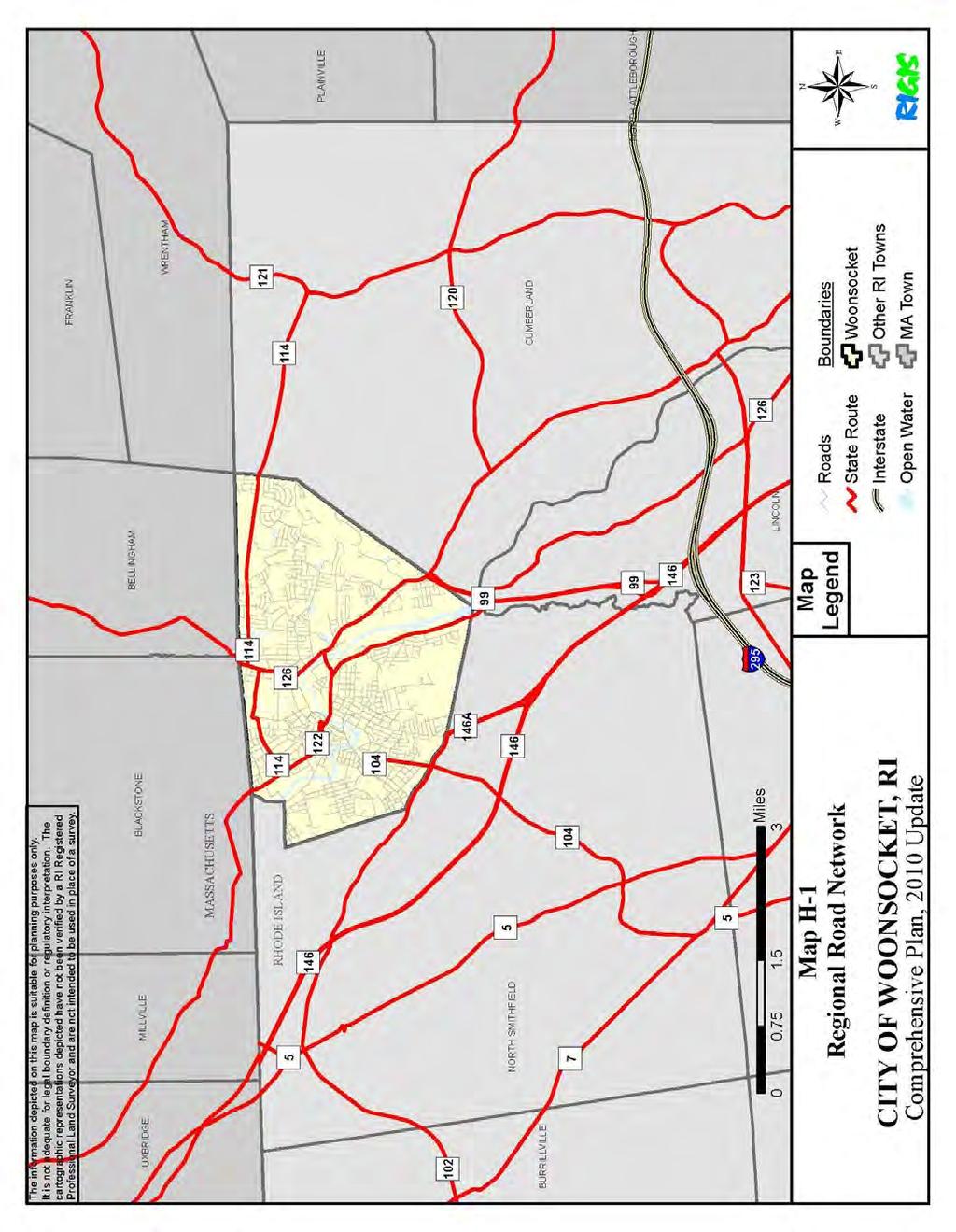
169 Circulation H-5
170 Circulation Access between Woonsocket and Worcester is provided by Routes 146A and 146. Route 146 continues from Woonsocket to the northwest as a divided, four-lane limited access highway for most of its 25 mile distance to Massachusetts Route 20 outside Worcester. From this point, drivers may access the Massachusetts Turnpike (Interstate Route I-90) over a short, circuitous route, or they may continue on Route 146 to Worcester. Route 146 turns into a two-lane undivided roadway between Route 20 and Worcester. Driving time between Woonsocket and Worcester is approximately 40 minutes. Access between Woonsocket and the Boston metropolitan area is less direct. Typical destinations to the northeast of Woonsocket include the metropolitan Boston area, Massachusetts Route 128 development, and Interstate Route I-495 development. There are several common routes drivers might take to these destinations. One route is south on Route 146A/146 to I-295 (or Route 122) and then east to I-95 and points north. This route is approximately 50 miles between Woonsocket and downtown Boston; driving time is approximately one hour during offpeak periods, and one and a half hours during the peak commuting hours. The other common routes to the north provide access to I-495 through the Massachusetts communities of Blackstone, Bellingham, Franklin, and Wrentham. One route follows Harris Avenue (Route 122) into Blackstone and then northeast to I-495 in Bellingham. Another begins at Social Street, Route 126 (and Mendon Hill Road, to a lesser extent) in northern Woonsocket, and follows local roads in Bellingham (Pulaski Boulevard), and Franklin (Washington Street - King Street) to access I-495 in Franklin. One may also follow Route 126 all the way through Bellingham (South Main Street/North Main Street/Hartford Avenue) to I-495. An alternative to these northern routes follows Route 114 from Diamond Hill Road east through Cumberland (Wrentham Road), then along Route 121 into Wrentham (West Street) where access to I-495 is gained via Route 1A. All of these northerly routes are over local, twolane undivided roadways. Travel speed on these local roads is relatively slow, but these routes provide shorter and quicker access to the rapidly developing I-495 corridor. These local routes to the north may experience increased use as more Woonsocket residents take advantage of the Massachusetts Bay Transit Authority (MBTA) commuter rail station on Route 140 in Franklin. Improvements for better northern access might include widening and upgrading portions of South Main Street/Main Street in Woonsocket, Route 126/Pulaski Boulevard in Bellingham, Massachusetts, and Washington Street/King Street in Franklin, Massachusetts. These improvements would be dependent upon the cooperation of the Commonwealth of Massachusetts and towns in both Rhode Island and Massachusetts. Access to Woonsocket from the west is also limited. Route 146A and Great Road in North Smithfield, and South Main Street and Providence Street in Woonsocket, comprise the primary routes serving this portion of the City. The possibilities for access improvements, especially to the Fairmount area, are constrained. The most reasonable solution requires the upgrading of Mendon Road in North Smithfield to Rhodes Avenue in Woonsocket. However, current land use constraints in North Smithfield lessen the potential for future access improvements in this location. H-6
171 Circulation A common problem of Woonsocket's connection with the entire regional road network is the absence of clear signs and route designations directing drivers into and out of Woonsocket. Signs on Interstate Routes 95, 295, and 495 indicate the exits to Woonsocket; however there are few, if any, signs marking these routes on the local roads. Signs reading "Entering Woonsocket" are placed on major routes in Massachusetts connecting with Woonsocket, and signs along Woonsocket's boundaries with other Rhode Island communities have been erected. Signage indicating that you can get to downtown Woonsocket has been installed at various points throughout the city, but the signage system could and should be greatly improved to better direct visitors into the downtown and help guide them back to the regional highway system. Map H-2 shows the City s road network, including State numbered routes. These are especially important to visitors unfamiliar with the local roads who try to navigate into or through the City via numbered routes. Improvements to State route and destination signing within the City are urgently needed to facilitate local traffic flow and assist motorists in reaching their destinations. State routes for many travelers are the primary guides for travel. Posting of signs at all intersections on State routes is critical. Regular inspections are needed to insure that missing signs are quickly replaced. City regulations require all truck traffic to follow numbered routes. Some of these routes, particularly downtown, are circuitous and poorly signed. Wherever possible, these routes should represent the most direct routing through the City. Use of one-way streets as State routes should be avoided to minimize confusion and the condition of State designated routes should be maintained at a high level. The four State numbered routes traversing the City (Route 104, Route 126, Route 122, and Route 114) should be reviewed periodically to insure that they are meeting these requirements, and needed improvements should be made as quickly as possible. Road Characteristics The City of Woonsocket has approximately 133 miles of roadway within its corporate limits. The vast majority of these roadways are under the jurisdiction of the City, with only a few miles of roads that are State maintained. There are two "typical" street types in the City, a 40-foot and a 50-foot right-of-way. A 40-foot right-of-way has a paved width of 26 feet with 7-foot sidewalks on each side. A 50-foot right-of-way has a 32-foot paved width with 9-foot sidewalks on each side. Map H-2 shows the city s road network and identifies which routes are classified by the State as functioning as freeways/expressways, as principal arterials, as minor arterials, as collectors, or as local roads. The State Department of Transportation defines and assigns the roadway classifications. Table H-1 lists the mileage of Woonsocket's functionally classified roads and those that are eligible for improvement with federal-aid monies. Local access and internal circulation is generally poor in Woonsocket. Travel through the City is complicated by the poor street conditions, insufficient destination signage, poor designations for truck routing, inadequate or poorly functioning traffic signals and congested streets. Traffic circulation within the downtown area has improved since Main Street s re- H-7
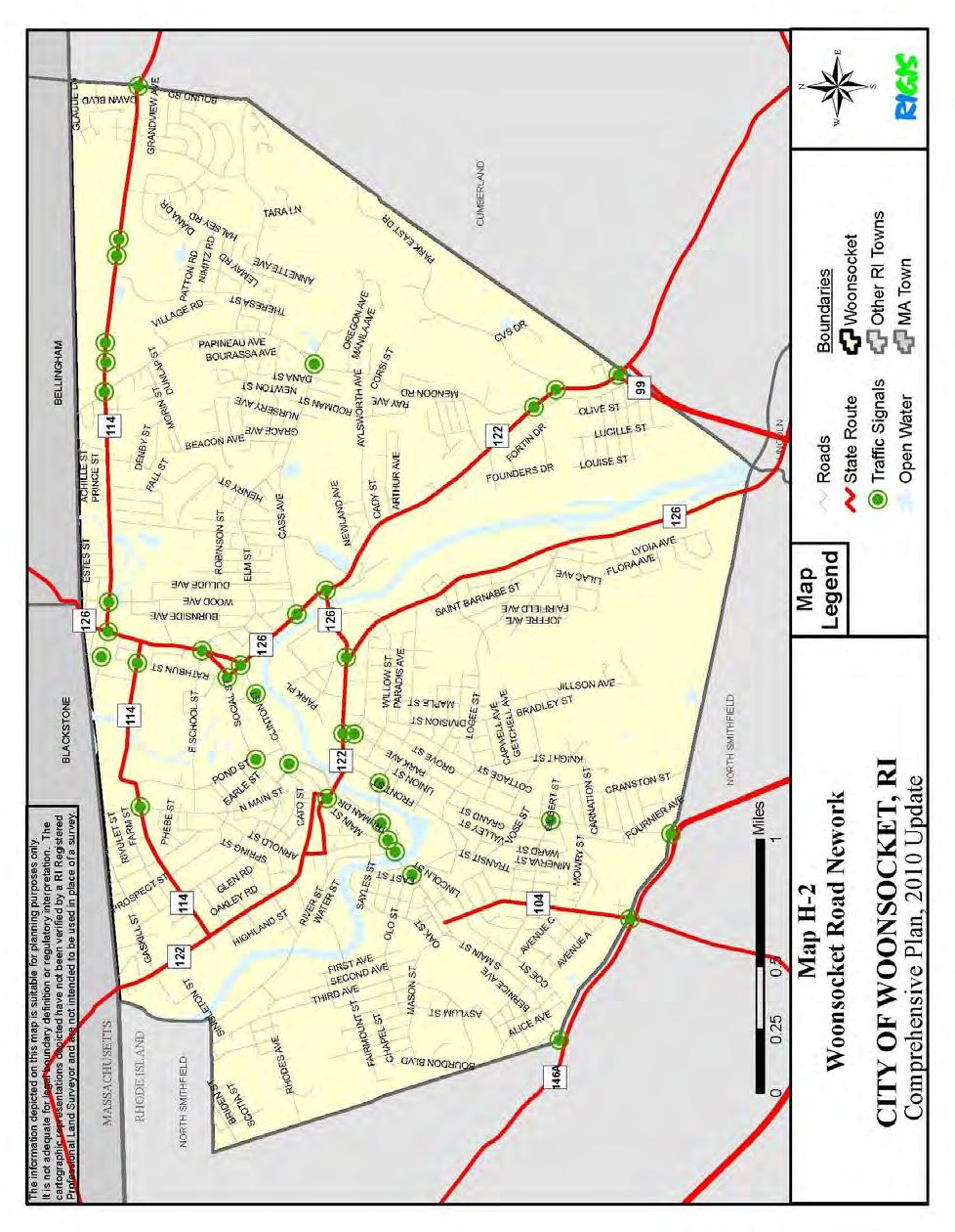
172 Circulation H-8
173 Circulation TABLE H-1 CITY OF WOONSOCKET FUNCTIONAL CLASSIFICATION MILEAGE Freeways and Expressways (Urban): Route Segment Name Miles 99 Woonsocket Industrial Highway 0.12 Total 0.12 Principal Arterials (Urban): Route Segment Name Miles --- Clinton Street Main Street Mendon Road Park Avenue Social Street Diamond Hill Road Court Square Court Street Cumberland Hill Road Hamlet Avenue Mendon Road Brook Street Cumberland Street Hamlet Avenue Social Street 0.63 Total Minor Arterials (Urban): Route Segment Name Miles --- Arnold Street Bernon Street Blackstone Street Cass Avenue Diamond Hill Road East School Street John A Cummings Way Main Street Mendon Road North Main Street Pond Street Providence Street Railroad Street Rathbun Street River Street South Main Street Sayles Street Truman Drive Wood Avenue Worrall Street 0.18 H-9
174 Circulation 114 Privilege Street Winter Street Arnold Street Harris Avenue Railroad Street Manville Road 1.77 Total Collectors (Urban): Route Segment Name Miles --- 2nd Avenue rd Avenue th Avenue Aylsworth Avenue Ballou Street Beacon Avenue Bernon Street Bertenshaw Road Bound Road Carnation Street Carrington Avenue Davison Avenue Elder Ballou Meeting House Road Elm Street Fairmount Street Front Street Gaskill Street Greene Street High Street Highland Corporate Drive Knight Street Logee Street Mason Street Morin Street Morse Avenue Pleasant Street Rhodes Avenue River Street Singleton Street St. Leon Street Transit Street Willow Street Winthrop Street High Street 0.23 Total City Total Source: RI Statewide Planning ( H-10
175 Circulation establishment as a two-way street. Improvements have also been made at both Market Square and Depot Square to improve existing operating conditions and provide an acceptable level-ofservice. Bridges Because of its development along the Blackstone River and the importance of railroads during the Industrial Revolution, bridges have played an important role in the roadway system of the City. Today some of the railroad bridges create an obstacle to truck routings. Vertical clearance at the Main Street, Clinton Street and Davison Street railroad bridges prohibit certain truck traffic from using these bridges. The administration of Woonsocket's road and bridge system is divided among a number of different City and State offices. RIDOT inspects all bridges in the City and has an existing program for addressing the replacement or rehabilitation of bridges. Bridge maintenance, however, is a City responsibility and the City must provide adequate financial and staff resources to support an ongoing bridge maintenance program. Many of the City s bridges that span the Blackstone River are covered in lead paint that, over time, has become worn and in need of removal and repainting. The RI Department of Environmental Management s stringent regulations regarding the lead paint abatement of these over-water structures make it cost prohibitive for the city to undertake this type of repair and maintenance. While the City supports policies and regulatory standards that protect the Blackstone River and human health, funding is not immediately available for this type of bridge maintenance. The City will pursue funding for these projects through many different avenues including CDBG and TIP. Prioritization of bridge repairs will be based on the bridge inspection reports that the City receives from RIDOT. Table H-2 lists the various bridges in the city and whether they are categorized as structurally deficient or functionally obsolete. RIDOT classifies a bridge as structurally deficient if there is elements of the bridge that need to be monitored and/or repaired. A structurally deficient bridge must be monitored, inspected and maintained, repaired or replaced at an appropriate time to maintain its structural integrity. The fact that a bridge is structurally deficient does not imply that it is unsafe. If unsafe conditions are identified during a physical inspection, the structure must be closed. RIDOT classifies a bridge as functionally obsolete if the bridge was built to standards that are not used today. These bridges are not automatically rated as structurally deficient, nor are they inherently unsafe. Functionally obsolete bridges are those that do not have adequate lane widths, shoulder widths, or vertical clearances to serve current traffic demand or to meet the current geometric standards, or those that may be occasionally flooded. Low and narrow bridge clearances on Main Street restrict the use of the street for trucks and create a hazardous condition. Proposals for truck routing on State numbered routes, and signing of traffic to Truman Drive will minimize the problem. Future plans by the State and the P&W to upgrade the railroad line should include more detailed engineering studies of reasonable alternatives for physically eliminating restrictions, and improving traffic flow through this area of the City. H-11
176 Circulation TABLE H-2 CITY OF WOONSOCKET, RIDOT BRIDGE RATINGS Year Bridge Name Bridge ID Year Built Reconstructed NBI Rating* Hamlet Avenue SD Harrison Avenue (RR) SD Mill Street FO Sayles Street Blackstone Street (RR) FO Harris Avenue Arnold Street (RR) FO Bernon Street Wood Avenue Diamond Hill Road FO Singleton Street River Street Fairmount Street S. Main Street south arch SD S. Main Street north arch Court Street FO Kendrick Ave. pedestrian Social Street East School Street Elm Street FO Privilege Street SD *(SD) Structurally Deficient, (FO) Functionally Obsolete Source: RIDOT, 2007 Traffic Control Devices Traffic control devices, including signals, signs, pavement markings, and traffic islands, assist in promoting the orderly flow of traffic. (See the Roads Network Map for locations of traffic signals and one-way streets in the City.) Observations were made as to the conformance of these control devices with the Manual on Uniform Traffic Control. In many instances pavement markings, warning and guide signs, and parking signs were not in conformance with this manual. Traffic signals within the City are in urgent need of upgrading. Many signals are over 20 years old and are a maintenance headache. Many of the traffic signals are functionally obsolete, and replacement parts are difficult or impossible to obtain. An inability to adjust signal phasing is also a problem with the older signal models. Traffic operations at busy intersections are hampered by signal systems that are out-dated. New signals, including fully actuated signals, would improve traffic flow through certain areas. The City has recently submitted, with the approval and recommendation of the State, a federal funding request for the upgrading of all existing traffic signals within the City which are currently inadequate or substandard. H-12
177 Circulation Parking The location of on-street parking areas influences the capacity and safety of local streets. Regulations for on-street parking are set forth in the Code of Ordinances for the City of Woonsocket, Chapter 17, Traffic. Off-street parking requirements and standards are governed by the City's Zoning Ordinance. In general, outlying residential areas have unrestricted curb parking on both sides of the street, except where roadway geometry or other physical characteristics dictate restriction of parking to one side of the street. Growth in both the number of automobiles per family and the number of new housing units in the City has contributed to an on-street parking problem in many residential areas, as most of the available off-street parking places are taken. This has placed pressure on neighborhood streets to accommodate additional on-street parking, often creating problems for emergency and maintenance vehicles. In addition, the demand for more off-street parking has increased paved yard areas, thereby decreasing open space and increasing stormwater runoff. Unless adequate off-street parking can be provided, the current on-street parking problem will prevail. The supply of parking in the Central Business District (CBD) is generally ample for the current level of usage. Parking availability within the downtown area, in terms of the number of spaces, is considered sufficient to meet existing and future needs. Two parking studies of the Main Street and Social areas of the downtown have been completed. The results of these studies indicate that some of the more pressing parking needs in the downtown area include: A program for the management of public parking facilities; Upgrading surface conditions, lighting and security in existing municipal lots; Improved signing of lots; Increased enforcement of parking regulations; and Designation of long-term and short-term parking facilities. In the downtown area curb parking is restrictive and its location has an important bearing on the roadway capacity. Therefore, the number and location of off-street parking facilities is an important consideration to both property owners and users. City zoning regulations currently require approximately 50% more non-residential parking spaces than recommended by the Institute of Traffic Engineers Handbook. Excessive parking requirements are costly to developers in terms of sacrificed building space and costly to the City in terms of decreased taxes. In this case, the need for parking appears to be less than what is required. Traffic Volumes The volume of traffic on roads assists in identifying major travel corridors. The volumes can also be compared with other factors (i.e.: road width, road condition, number of accidents, etc.) to identify possible inadequacies in the circulation system. Traffic volumes were determined from RIDOT traffic counts taken in 2007/2008, both along roads and at intersections. These traffic counts are shown in Table H-3: Average Annual Daily Traffic, H-13
178 Circulation Roadway Mendon Road TABLE H-3 AVERAGE ANNUAL DAILY TRAFFIC, 2009 Average Daily Traffic Rte. 99 to Cumberland Hill Rd. 29,600 Cass Ave. to Diamond Hill Rd. 14,700 Cumberland Hill Road Mendon Rd. to Hamlet Ave. 19,700 Hamlet Ave. to Congress St. 17,900 Manville Road City boundary to Bertenshaw Rd. 7,700 Bertenshaw Rd. to Hamlet Ave. 8,600 Social Street Pond St. to Cumberland St. 13,700 Diamond Hill Rd. to Mass. state line 9,500 Clinton Street Cumberland St. to Worrall St. 5,000 Rte. 146A / Providence St. 10,600 Diamond Hill Road Bound Rd. to Mendon Rd. 10,600 Mendon Rd. to Social St. 14,100 Social St. to Massachusetts state line 700 Mendon Rd. to Cumberland town line 8,200 Source: RIDOT, 2008 Traffic Flow Map ( Some of the most heavily traveled roadways in Woonsocket, according to 2007/2008 RIDOT traffic counts, include Mendon Road (from Route 99 to Diamond Hill Rd), Cumberland Hill Road (from Mendon Rd to Hamlet Ave), Diamond Hill Road (from Mendon Rd to Social St), and Social Street (from Cumberland St to Pond St). These sections handle over nearly 14,000 vehicles per day. Other heavily traveled roadways are identified in Table H-3. Traffic volumes demonstrate the relationship between land use patterns and transportation networks: Heavy traffic along Diamond Hill Road reflects the development of East Woonsocket and the plazas and large retailers on Diamond Hill Road. High levels of traffic on Mendon Road and Cumberland Hill Road reflect the influx of traffic from this direction due to Route 99. Social Street traffic reflects trips to the shopping areas in the Social area as well as trips to the shopping areas on Diamond Hill Road and commuter traffic traveling north to I-495 While there are not specific traffic counts for Truman Drive, anecdotally it is felt that this road has very low traffic counts as there are rarely queues at the two Truman Drive traffic signals. Truman Drive is viewed as an impediment to Main Street revitalization and the H-14
179 Circulation City would support future lane reductions to accommodate a bicycle path and other pedestrian and beautification improvements to the area. Major Trip Origins Land use is an important factor in the development of travel patterns. Residences are considered trip origins, while employment, shopping, and City offices are trip destinations. In addition to helping determine general travel patterns, the land use information is used to address the need for transit services. The concentration of housing units is a major factor in determining the number of trips that will originate in an area. A study in the 1990 s looked at trends in housing concentration in the City, using summaries of the City's tax assessor's records for more detailed information. The number of housing units was divided by the reported area to determine housing concentration. (See Table H-4) Areas with between 1 and 4 units per acre are considered moderate density housing, areas with between 5 and 8 units per acre are considered high density housing, and areas with more than 8 units per acre are considered very high density housing. TABLE H-4 RESIDENTIAL UNITS AND TRIPS GENERATED, 1990 (BY ASSESSOR'S PLAT) Plat # # Res. Units Acreage Density (units/ac) Daily Trips % Total Trips Peak Hour Trips Very High Density Areas: , % 2, , % 3, , % 2, , % 2, , % 2, , , % 3, , % 3, , % 2,611 Subtotal 6, , % 24,075 High Density Areas: , % 1, , % 1, , % 1, , % 2, , % 2, , % , % 1, , % 1, , % 2, , % 1, , % 1,914 H-15
180 Circulation , % 1, , % 1,030 Subtotal 6,217 1,049 35, % 21,533 Moderate Density Areas: , % , % , % , % , % , % , % , % 1, , % , % , % % % , % % , % % % % , % , % , % % , % % % , % , % , % % % % , % % % , % % % , % , % 393 Subtotal 6,020 3,137 56, % 6,980 Total 18,739 18,739 4, , % 52,588 H-16
181 Circulation The high and very high density residential areas generally occur in the center of the City near the river. Apartment complexes located toward the margins of the City increase the density in some areas away from the City center. The highest density plats are in the areas of Fairmount, Front Street, Social Street-Cass Avenue, and West School Street. The housing information was used to determine the number of trips that would originate in each area, based on standard numbers of trips from various types of housing. Table H-4 indicates that approximately 30% of the trips in the City originate in the highest density plats. Another 25% originate in the high density areas. More than 50% of the trips originating in Woonsocket come from the central one-third of the City. Major Trip Destinations Land use other than residential areas accounts for the major trip destinations. Most of the major employers and mills are concentrated along the Blackstone River and in the center of the City north of the Blackstone, along the Mill River. Major employers are also located in East Woonsocket, near Aylsworth Avenue, along Fortin Drive, and in the Highland Industrial Park. Certain of these employers represent destinations for trips other than employment. These include the City's shopping centers, hospital, larger schools, and City offices. Most of the shopping centers are located at the edges of the City. Other commercial areas, the hospital, and the City offices are located near the geographic center of Woonsocket. Table H-5 lists places of employment for Woonsocket residents. As the table shows, of Woonsocket s 18,700 member workforce, 34% of residents work in Woonsocket, making this the single largest place of employment for residents. Other significant employment centers for Woonsocket residents include Norfolk County, Massachusetts, which is an employment destination for 16% of Woonsocket residents. Norfolk County includes the southeastern Massachusetts communities such as Franklin, Wrenthan, and Bellingham. Approximately 20% of Woonsocket residents work in the Providence area, including Providence, Lincoln, Cumberland, Pawtucket, and North Smithfield. High Hazard Locations 2008 accident reports from the Woonsocket Police Department were reviewed to determine locations with high accident rates. High accident rates may indicate areas with problems such as inadequate signals or obstructed visibility. Frequent accidents occurring on roads with relatively lower traffic volumes raise special concerns about the safety of these roadways. The locations of high accident rates are shown early in Table H-6, a 2008 Accident Summary for the City of Woonsocket. They generally correspond with the heavily traveled roads, including Mendon Road, Cumberland Street, Diamond Hill Road, Clinton Street, Cumberland Hill Road, and Cass Avenue. H-17
182 Circulation TABLE H-5 PLACE OF EMPLOYMENT FOR CITY OF WOONSOCKET RESIDENTS Place of Employment Number of Workers Percent of Workers Woonsocket 6, % Norfolk County, MA 3, % Worcester County, MA 1, % Providence 1, % Other Massachusetts 1, % Middlesex County, MA % North Smithfield % Lincoln % Cumberland % Pawtucket % Cranston % Smithfield % Warwick % East Providence % Other Rhode Island Cities and Towns % Connecticut % Total Workers 18, % Note: Numbers and/or percents may not equal totals due to data reported and rounding Source: U.S. Census Bureau, Census 2000 Intersection TABLE H-6 ACCIDENT SUMMARY, CITY OF WOONSOCKET, 2008 # of Accidents Diamond Hill Road - Mendon Road 49 Cumberland Hill Road - Mendon Road 30 Clinton Street - Cumberland Street 23 Cumberland Street - Cass Avenue 21 Diamond Hill Road - Rock Ridge Drive 21 Diamond Hill Road - Walnut Hill Road 21 Mendon Road - Cass Avenue 20 Social Street - John A. Cummings Way 16 Cumberland Street - Socail Street 15 Social Street - Pond Street 15 Cumberland Hill Road - Hamlet Avenue 14 Clinton Street - John A. Cummings Way 13 Clinton Street - Pond Street 13 Diamond Hill Road - Social Street 13 Diamond Hill Road - Wood Avenue 13 East School Street - Rathbun Street 13 Hamlet Avenue - Park Avenue 11 Cass Avenue - Dulude Avenue 10 H-18
183 Circulation Diamond Hill Road - St. Leon Avenue 10 Park Avenue - Logee Street 10 Privilege Street - Roland Street 9 Social Street - Worrall Street 9 Wood Avenue - Elm Street 9 Cumberland Hill Road - Founders Drive 8 Cumberland Street - Hamlet Avenue 8 Diamond Hill Road 8 Hamlet Avenue - Manville Road 8 Mendon Road - Elder Ballou Mtg House Road 8 Park Avenue - Smithfield Road 8 Providence Street - South Main Street 8 Blackstone Street - Harris Avenue 7 Cumberland Hill Road - Aylsworth Avenue 7 Cumberland Hill Road - Columbus Avenue 7 Harris Avenue - Gaskill Street 7 Main Street - High Street 7 Mendon Road - Talcott Street 7 North Main Street - Winter Street 7 Park Avenue - Fournier Avenue 7 Social Street - Privilege Street 7 South Main Street - Pleasant Street 7 Wood Avenue - Robinson Street 7 Bernon Street - Front Street 6 Bernon Street - Truman Drive 6 Clinton Street - Truman Drive 6 East School Street - Pond Street 6 Front Street - Transit Street 6 Main Street - Railroad Street 6 Park Avenue - Vose Street 6 Providence Street - Smithfield Road 6 Rathbun Street - Elbow Street 6 Cumberland Street - Kendrick Avenue 5 Cumberland Street - Locust Street 5 Diamond Hill Road - Rathbun Street 5 Hamlet Avenue - Davison Street 5 Manville Road - Gadoury Boulevard 5 Manville Road - Willow Street 5 Mason Street - Second Avenue 5 Mendon Road - Aylsworth Avenue 5 Mendon Road - Village Road 5 Park Avenue - Bernon Street 5 Park Avenue - Transit Street 5 River Street - South Main Street 5 Wood Avenue - Mill Street 5 Source: Woonsocket Police Department H-19
184 Circulation High hazard locations in the City generally point to a need for increased capacity at intersections, improved traffic signals and better enforcement of regulations. However, it is also important to consider that it would follow that intersections locations which have greater total traffic counts will normally see higher traffic accidents. Nonetheless, it is important to consider areas with high numbers of traffic accidents when considering how to prioritize future roadway improvement projects. The following intersections saw the highest number of accidents in 2008: Diamond Hill Mendon Road (49) Cumberland Hill Mendon Road (30) Clinton Cumberland Street (23) Diamond Hill Walnut Hill Road (21) Diamond Hill Rock Ridge Drive (21) Cumberland Cass Avenue (21) Mendon Cass Avenue (20)* *It is worth noting that a left-turn signal was recently installed at the traffic light at the intersection of Cass Avenue and Mendon Road to benefit northbound travelers on Mendon Road wishing to make a left onto Cass Avenue. With this signalization improvement, a reduction in accidents is expected at this intersection in future years. Truck routing through the City necessitates several isolated intersection improvements. Observations of truck movements indicate poor turning radii along Park Avenue, making through truck turns difficult and dangerous when a truck has to cross lanes to make a turn. Action to move stop lines back and widen certain intersections would improve this situation. State numbered routes should be designated along streets where through truck turns can be made safely. Emergency Services Emergency services provided by the City include police, fire, and rescue services. The City road network is an important factor in the response time of these services to an emergency. Woonsocket's road network is also important to rescue organizations outside the City because the Landmark Medical Center, Woonsocket Unit provides the only 24 hour hospital emergency room be made safely. Emergency Services Emergency services provided by the City include police, fire, and rescue services. The City road network is an important factor in the response time of these services to an emergency. Woonsocket's road network is also important to rescue organizations outside the City because the Landmark Medical Center, Woonsocket Unit provides the only 24 hour hospital emergency room for Northern Rhode Island and adjacent communities in Massachusetts. H-20
185 Circulation The Superintendent of Fire Alarms maintains City operated traffic signals. The abundance of antiquated, malfunctioning lights can pose additional delays in response time. Computer control of traffic lights from the fire station is a priority at the intersections of Hamlet Avenue and Manville Road, Cass Avenue and Cumberland Hill Road, Kendrick Avenue and Cumberland Hill Road and others. This would conceivably help to improve circulation overall and allow fire fighters to clear the lights for their emergency vehicles. Given the older infrastructure in the City, some roadways need improvement. The Public Works Department anticipates repaving several roadways this calendar year including Diamond Hill Road, Carrington Avenue, Cumberland Street, Hamlet Avenue, Cherry Hill Road, Miller Lane (in conjunction with a sewer project), and a portion of Hazel Street. Additional roadways will be improved over time. Improved roadways will facilitate a smoother traffic flow, limit wear and tear on vehicles and may improve emergency response time. The roadway layout and design is a problem in some instances. Congestion at Hamlet Avenue and Cumberland Hill Road creates problems for Station No. 2, as does congestion at Hamlet Avenue/Manville Road and Manville Road/Davison Avenue. Depot Square and the Court Street Bridge create problems for Station No. 3. Station No. 3 is at North Main Street and Shorr Court, a blind corner, and Station No. 6 is in the Fairmount neighborhood where street widths are very narrow. Problem areas for Station No. 4 include the intersections of Mendon Road and Elder Ballou Meeting House Road, and Wood Avenue and Diamond Hill Road. Bridges are a particular problem for fire vehicles due to weight limitations. Some of the vehicles weigh 14 tons and exceed the weight limitations on certain City bridges. Additionally, there are bridges that the apparatus cannot pass under, specifically the Sayles Street Bridge. The City has obtained special exemptions from RIDOT for emergency use of these bridges by fire trucks. Administration Various federal agencies have authority over roadway and circulation programs and projects. The Federal Highway Administration (FHWA) plays a major funding role in State highway and bridge improvements, including repair, upgrade and new construction of roads and bridges. FHWA has detailed planning and design requirements for projects it is involved with. RIDOT typically assumes a lead role in ensuring FHWA requirements are met on federally funded projects. Major federally funded projects with a potential for significant environmental impacts may also trigger the involvement of the U.S. Army Corps of Engineers, the U.S. Environmental Protection Agency, and the U.S. Fish and Wildlife Service, among others. The RIDOT has the lead role in roads and bridges which come under State jurisdiction. RIDOT's planning and design sections have on-going programs for road and bridge upgrades and new construction. RIDOT also provides funding in conjunction with the FHWA and contract administration for construction projects. RIDOT is responsible for maintenance of roads and bridges under their jurisdiction. The Rhode Island Department of Administration, Division of Statewide Planning, is responsible for preparing a State long-range ground transportation plan. The Division of Statewide Planning also has a role in roadway planning, including computer modeling of traffic H-21
186 Circulation circulation, forecasts of future travel demands, and preparation of the State Ground Transportation Plan. In addition, this office is responsible for the review of local comprehensive plans for consistency with State policies. While the Engineering and Highway Divisions of the Public Works Department have the most direct control over Woonsocket's road and bridge system, various aspects of circulation, traffic safety, road and bridge maintenance, and transit services are controlled by several departments in the City. Public Works is responsible for road maintenance but does not have the equipment for bridge maintenance. Major road repairs are presently contracted out. The department coordinates with RIDOT and with other City departments on major road upgrades and new road development. The City Council and the Mayor's office have the responsibility of setting City policy with regard to roads and bridges, as carried out in their approval of general fund and special fund budgets, and the Finance Department provides financial control and purchasing services. The Police Department has primary responsibility for traffic safety, including enforcement, maintenance of signs and accident statistics. The Police Department Traffic Bureau maintains records on accidents and patrol officers enforce traffic regulations. The Fire Department has primary responsibility for City traffic light maintenance. The Department of Planning and Development is responsible for transportation planning, zoning, and subdivision review, and the Department of Human Resources oversees 34 human service agencies, many of which provide transportation services. Finally, the Department of Education is responsible for school bus operations including schedules and routes. This Department sets policy on how far children of a certain grade must live from school before they are eligible for bus service. The Education Department also has a lead role in determining where schools are located, thus influencing bus, automobile, and pedestrian travel patterns to some degree. This sharing of responsibility can result in a certain level of inefficiency when problems arise. Projects can occur that are outside of an individual department's purview, and two or more departments may end up duplicating efforts. There is a need for coordination of all transportation and traffic functions under one responsible party, to better enable coordination with State and local agencies, and to ensure that the City's needs are addressed in State projects. Traffic, safety, and parking regulations are only effective when consistently enforced. The City must ensure sufficient staff for the enforcement of parking and traffic regulations. The need for enforcement staff stands out as an important aspect of the overall goal to improve circulation and parking in the City. System Improvements The RIDOT is responsible for the distribution of federal highway funds within the State, according to a Transportation Improvement Program (TIP) which is approved by the State Planning Council/Metropolitan Planning Organization. The TIP, is a multi-year program of all H-22
187 Circulation planned highway, bicycle, pedestrian, and intermodal transportation projects. While the State prepares the program, the individual communities throughout the State have an opportunity to submit project requests to the State. Because Rhode Island receives a limited amount of federal highway moneys, funding is limited for the addition of projects to the program. For a project to be considered for the TIP, it must be on a federal-aid system. Once a project is included on the State's program, the State is responsible for the funding, design and construction of the project. The implementation time for a project is generally 36 months; however controversial projects take considerably longer. An evaluation of existing and future conditions within the City highlights the need for several new or improved road access projects. The process of developing new or improved access to major generators or to developing areas is a long and often complicated process. The time frame for planning and construction of Route 99 demonstrated the amount of lead time required for complicated projects and underscores the importance of carefully considering all factors before deciding on any course of action. Throughout the City changes in land use, traffic, and standards for roadway design have left many City streets in need of improvements beyond resurfacing. Many of the arterial and collector roads in the City are inadequate for today's operating condition. Projected changes in land use and traffic volume will further exacerbate this problem. Observations of roadway problems include: physical obstructions (i.e.: utility poles) that are close to the roadway creating hazardous operating conditions, shoulders that are used for travel lanes where traffic has grown beyond the roadway capacity, inadequate street lighting and poor drainage systems. The TIP is the primary mechanism the City currently has to fund improvements. The City has had opportunities in the past to request projects for State consideration and will have similar opportunities in the future. Invariably the needs of a community outweigh funding limitations, and competition for scarce resources is great. A systematic program for collecting data on pavement conditions, traffic volumes, accidents and land use, combined with a process for evaluating these variables, will enable the City to accurately document its road improvement needs, and thus remain a strong competitor under the TIP program. Planned and on-going RIDOT road projects in the Woonsocket area are as follows: Roadway Projects - Rt R Improvements Pavement Management Program, improvements along Diamond Hill Road from Peters River to Bound Road. Work to be completed in Rt. 99 1R Improvements Pavement Management Program, improvement to Rt. 99 from Route 146 to Mendon Road. Work to be completed in Diamond Hill Rd. Study & Development Program to look at stretch of Diamond Hill Road from Peter s River Bridge to Social Street. The completion of Route 99 in the early 1990s provided a new and necessary highway access point in to the City of Woonsocket. Route 99 provides direct highway access to the City s H-23
188 Circulation Highland Corporate Park and the Woonsocket Industrial Park on Cumberland Hill Road. It is a vital part of Woonsocket s transportation network. Diamond Hill Road functions as a principal arterial and serves as the primary east-west route in the northern section of the City. Increased development of shopping areas and residential growth in both Woonsocket and southern Bellingham will result in increased traffic. The section of Diamond Hill Road between Mendon Road and Social Street is incompatible with the eastern portion of the road. In order to best serve future traffic, Diamond Hill Road must be upgraded to a consistent standard, a project currently listed in the TIP. As part of the Main Street Riverfront Initiative Group (formerly Main Street 2000) Revitalization Program, improvements have been implemented for the Main Street area from Market Square to Monument Square. Improvements included redesign of the traffic rotary at Monument Square and improvements to traffic flow along Main Street from Depot Square to Market Square. Main Street was changed from one-way to two-way traffic as a way of improving circulation through the downtown area. Maintenance There has been no continuous process within the City for the implementation of a comprehensive program of planned improvements to roads, bridges and traffic circulation. In the absence of a comprehensive maintenance program, the pavement condition on many City streets has deteriorated. Funding and personnel constraints have seriously limited the Department of Public Works' ability to keep up with the need for a regular program of resurfacing City streets. Funds have been allocated on a crisis basis, rather than in accordance with a planned improvement program. The Public Works Department is working toward the development of a Pavement Management Program to assist the City in safeguarding its investment in streets by both assessing need and prioritizing projects. The City is working with RI Statewide Planning and the Rhode Island Technology Center on Pavement Management. In the absence of funding, the City will seek outside sources of funding including CDBG and the TIP. In the absence of funding, the City will continue to face a serious road maintenance problem. Public Transportation Public transportation and para-transit services provide transportation alternatives to private automobile travel. Reducing automobile traffic can help reduce pollution and demand for petroleum products. Public transportation services provide opportunities for residents who do not drive or who do not own automobiles. It is important for such services to access the residential areas and destinations described above, especially where concentrations of elderly or low-income residents require service. H-24
189 Circulation The Rhode Island Public Transit Authority (RIPTA) provides the only fixed route bus service to and within Woonsocket. Table H-7 and the Public Transportation Map (Map H-3) present the routes, frequency of trips, and the average daily number of riders on each route. These RIPTA routes provide transportation from some of the most densely developed neighborhoods such as Fairmount and Constitution Hill to such destinations as downtown Woonsocket, Diamond Hill Road, the vocational and high school (when school is in session), Park Square, Lincoln Mall, CCRI in Lincoln, and Providence. TABLE H-7 RIPTA BUS ROUTES SERVIING THE CITY OF WOONSOCKET Number of Runs per Day Route # Name Avg. # Rides per Day Daily/Weekend Service 54 Lincoln/Woonsocket 1, Daily/Sat/Sun 87 Fairmount/Walnut Hill Daily/Sat/Sun Rides includes both inbound and outbound passengers Source: RIPTA, Since the original writing of this Comprehensive Plan, RIPTA has made significant cuts to bus service in Woonsocket. Currently, the existing bus service is insufficient to meet the needs of many city residents, especially the 17% of residents in Woonsocket who do not have access to a vehicle. Woonsocket residents are disproportionately impacted by cuts to public transit because of the significantly higher percentage of Woonsocket residents who do not have a car as compared to just 11% in the State as a whole. The existing bus service is insufficient to meet the needs of job seekers looking for second or third shift work as the busses do not run frequently enough, there are not enough express routes, the busses do not enter many of Woonsocket s neighborhoods, and do not arrive at several major employment centers such as Highland Corporate Park, Woonsocket Industrial Park, or the job centers in nearby Franklin, Massachusetts. Every effort should be made to advocate for the improvement of RIPTA bus service to Woonsocket and to protest any further cuts to service. Several transit agencies operate in the City, generally providing some transportation for elderly, disabled, or low-income residents. Senior Services provides round trips every morning and afternoon for disabled and elderly adults in the Adult Day Care program. The agency provides transportation for grocery shopping, medical appointments, and emergencies. Two weeks notice is required for trips to medical appointments. Northwest Transportation Service, Inc., a private non-profit transportation provider, serves low-income elderly, handicapped, and disabled residents. It brings clients to medical appointments with two weeks notice. Daily trips are made into Providence for appointments. The agency also provides some transportation to meal sites. Retired Seniors Volunteer Program (RSVP) provides a limited amount of transportation services to fill gaps. The group has a Meals on Wheels service and brings senior volunteers to their work sites. In addition, some of the local grocery stores provide van service to bring elderly residents to and from the stores. The City rents school buses, which are used to make round trips to and from school each day. Students who live within a defined walking distance from their schools do not take buses, H-25
190 Circulation and many travel as pedestrians. During the school year, the 87 Route RIPTA bus makes one stop at the high school each morning and afternoon on school days. Transportation services available in Woonsocket were compared with land use and housing information to identify residential areas and destinations not adequately served. Transportation services are especially important for elderly and low-income residents, who may not have the option of driving. While transit agencies provide a certain amount of transportation services for low-income, disabled, and elderly, several areas of unmet transportation needs remain. Many elderly or disabled clients have difficulty in getting to medical appointments due to scheduling problems. Trips to specialists in Boston, Providence, or elsewhere often prove difficult. Residents also require trips to shopping centers, banks, job training, public offices, and employment areas. Presently, the low-income residents have fewer options than the elderly or disabled and should be targeted for future programs. Unemployed residents who cannot get to a job site to fill out an application or to work will remain unemployed. RIPTA provides the most continuous transportation service. However, many subsidized/elderly housing complexes are not on the bus routes, requiring long walks to bus service. In some cases, the buses cannot access the housing units due to narrow roads or driveways. The Cumberland Hill Road bus only provides service on Saturday, offering limited options for residents of Plaza Village and providing no service to the Highland Industrial Park. Since Woonsocket was not designed around the automobile, its ability to expand roadway capacity and add new roadways in the future is limited. Improved and expanded transit services, both inter-city and intra-city, may reduce the need for additional roadway improvements. Future studies are needed to evaluate employee incentives for increasing transit usage and developing new intra-city routes to provide efficient connections between the population centers of the City and major employment areas. Bicycle and Pedestrian Traffic RIDOT and the Rhode Island Department of Environmental Management are underway in the planning and construction of the Blackstone River Bikeway (see Open Space & Recreation and Heritage Corridor Elements). As of 2009, the Bikeway has been constructed to Davison Avenue and plans for its construction across the rest of the city are underway. The Bikeway will generally follow the course of the Blackstone River. Its path will alternate between independent rights-of-way and existing roadways. The next segment of the Bikeway will provide access to downtown Woonsocket: River Island Park, Main Street, Market Square, and the Museum of Work and Culture. H-26
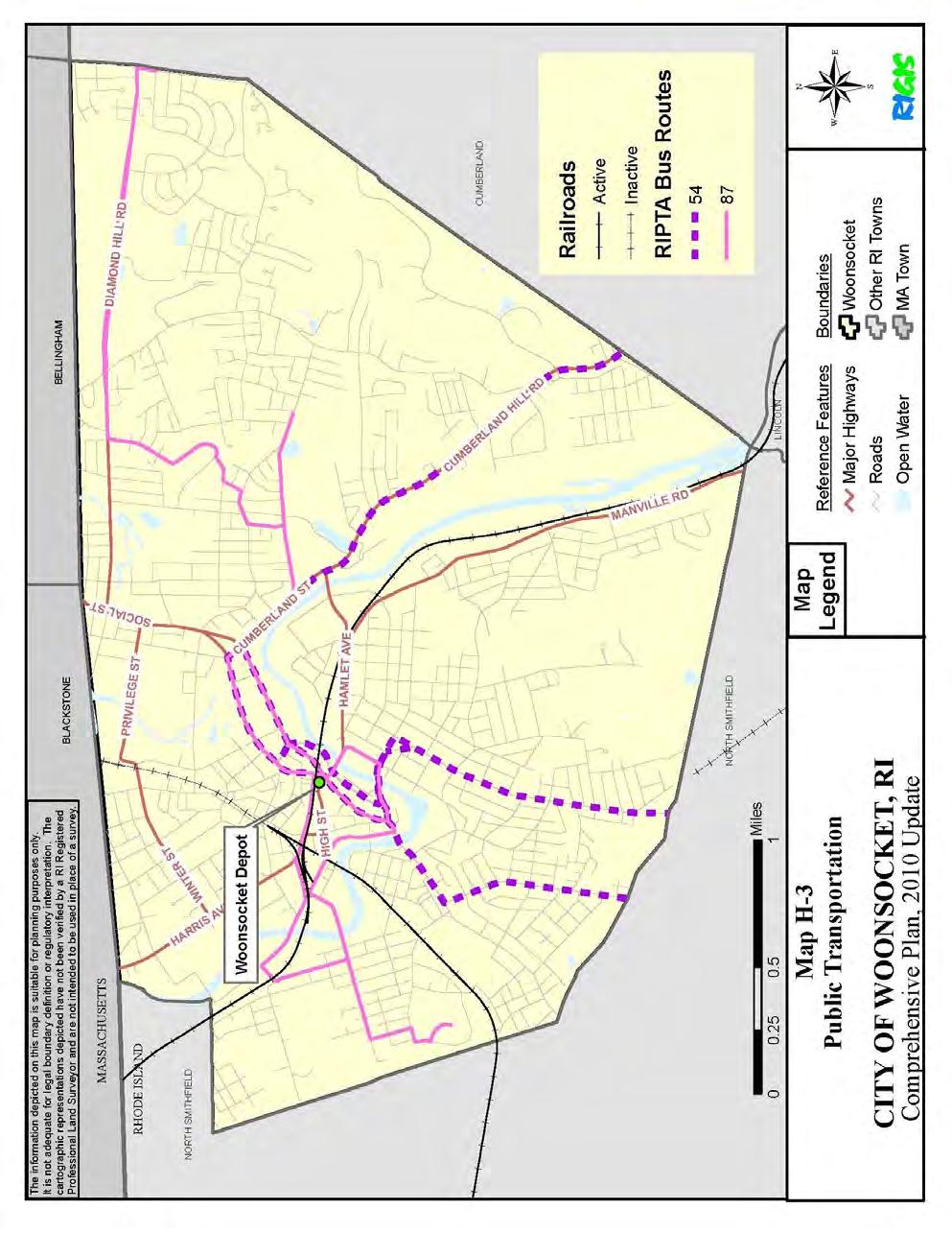
191 Circulation H-27
192 Circulation Locations where the Bikeway might encompass existing streets in Woonsocket include Truman Drive, Bernon Street, Water Street, Fairmount Street, and River Street. In each of the locations where the Bikeway will share the road with vehicular traffic, the principal consideration will be safety for both bikers and motorists. When the Bikeway is on its own right-of-way, access to certain sections might be restricted to selected locations. In other sections, access will be unrestricted from adjoining areas and streets. The Bikeway is intended as an alternative transportation facility, and the design and route will be based on safety, grades, accessibility, cost, route continuity, and environmental impacts. Coordinating the design of the Bikeway will need to be considered in conjunction with other city projects and improvements. Because the proposed Bikeway design will include the use of local streets as well as independent rights-of-way, the City should become an active participant in the design phase of the study. The City will need to identify local concerns and ensure that State and City objectives are compatible in determining the final location and design of the Bikeway. In certain locations, it is proposed that the Bikeway will be constructed atop the city s flood control levees. The City should play an active role in advocating that the Bikeway be constructed as close as possible to the Blackstone River, while at the same time ensuring that the City s flood control system remains effective in protecting the city from flood events. The City should work with all parties to support the continuation of the Bikeway to the Massachusetts line and through to Worcester, Massachusetts. The Bikeway is expected to have a very positive effect on adjoining land uses. However, as interest and use increase, businesses and activities that would benefit from the bicycle traffic are likely to locate closer to the path. The proximity of the Bikeway to the Blackstone River will make it an attraction. As final planning begins, the City should evaluate opportunities to tie residential areas to the Bikeway with local street improvements and should consider the development of a City signage plan. As part of the City s Wayfinding Master Plan for Downtown Woonsocket, improved pedestrian and bicycle connections within the downtown area are being planned. A concerted effort should be made to capitalize on the Bikeway as a means of revitalizing downtown Woonsocket and the Blackstone Riverfront area. Creative and consistent Bikeway signage that connects the Bikeway into the downtown fabric is critical to successfully capitalizing on the benefits of Bikeway. Railroads Woonsocket has two active railroad lines in the City, the P&W Main Line and the Slatersville Secondary Track. Both lines are owned and operated by the Providence and Worcester Railroad. The P&W Main Line is 12.5 miles long. It runs from the Massachusetts State line in Woonsocket through North Smithfield, Cumberland, Lincoln and Central Falls to its connection with the State Line in Pawtucket. The majority of freight traffic carried on the Main Line is classified as through traffic going from P&W's Worcester freight yards to the Providence area. Local service, however, is still provided at least once a day, excepting Sunday. H-28
193 Circulation The Slatersville Secondary Track is approximately 4 miles long. It is located in the City of Woonsocket and extends into the Town of North Smithfield. Service on this line is currently provided on an "as needed" basis and is available 6 days a week. A portion of the Slatersville Secondary Track was abandoned by the P&W in 2007, severing its connection north of East School Street. Deregulation of the railroads in the 1970s and changes in the economic environment of the area (as well as the entire Northeast) have resulted in a general decline in all rail services. Information on the businesses in the City of Woonsocket that are currently using rail service is not available. The State does not have statistics on users of rail freight service in the City nor on the amount of freight being carried by commodity type. There is presently no rail passenger service provided on any of these railroad lines. Traffic previously handled exclusively by the railroads has been diverted to trucks. Except for some bulk commodities, like coal and scrap, the trucking industry competes with railroads in almost all areas. Industries in Woonsocket that were once serviced only by rail are now shipping via truck. New industries coming into Woonsocket are less likely to use rail freight as a means of transporting or receiving their products. The most pressing obstacles to continued rail service in Woonsocket involve height and width clearances at several locations in the City. Interconnected rail service is a key to the future viability of the Main P&W Line. The ability to compete with trucking and other rail carriers in the northeast will require that certain local height and width restrictions be removed, particularly at Arnold Street and Blackstone Street, so that the rail line can accommodate higher and wider shipments from Worcester to East Providence. P&W has identified this as part of their strategic plan for remaining competitive with other carriers. The continuation of railroad services to Woonsocket is dependent upon the strength of the economy and demand for the use of rail freight service. In turn, the attraction to Woonsocket of industries which require use of the railroad will be dependent on the continuation of these services by the P&W Railroad. Ongoing track and bridge maintenance projects are planned by P&W, in cooperation with the State, to insure that the rail lines are kept in service. The return of passenger rail service along the P&W line is an extremely desirable goal for the future. Passenger service would provide a new transportation opportunity for the Blackstone Valley, facilitating an alternative method of commuting between Woonsocket and Providence. Two preliminary feasibility reports have been completed, which state that commuter rail service from Woonsocket to Providence is both feasible and has significant ridership numbers to be competitive. Commuter rail, if resumed along the P&W line would link Woonsocket with the T.F. Green airport in Warwick via the new intermodal Warwick station and potentially, to Boston by transferring at the proposed Pawtucket/Central Falls MBTA station. Commuter rail service in Woonsocket would greatly benefit both Woonsocket s residents and businesses alike. It would also aid tourism activities in Woonsocket and the surrounding area. The City should continue to work towards bringing commuter rail service to Woonsocket along the P&W line and should oppose any projects that might limit this possibility. H-29
194 Circulation Air Transportation The only commercial airport in Rhode Island is T.F. Green State Airport. Woonsocket is approximately 20 miles from T.F. Green. The next closest commercial airport is Logan which is located in Boston and is miles from Woonsocket (depending upon the route taken). Industries using corporate or charter air services can currently use North Central Airport in Lincoln, R.I. located on Route 116 (George Washington Highway). Emergency medical needs are served by a designated helicopter landing area near the Landmark Medical Center, off of Cumberland Hill Road. Economic Development Access is a crucial factor in encouraging economic development. The City has identified several areas for development where improved access is required. Those areas include Diamond Hill Road. As various mills in the City are redeveloped, the need for access by employees and trucks will have to be evaluated on a case by case basis. Safe access to individual businesses is needed to develop or redevelop areas in the City. It may be necessary to combine internal circulation for businesses along heavily traveled roads where increased development might otherwise result in an excessive number of new curb cuts. Economic development in the Main Street area depends on the availability of adequate parking and useful directional signage to guide visitors in and out of the downtown area. A close look should be given to the adequacy of the city s existing directional signage. NEW INITIATIVES Study and Development for Commuter Rail in Woonsocket Now that two commuter rail feasibility studies have concluded that commuter rail from Woonsocket to Providence is feasible, the next step is to get funding under Study and Development in the Transportation Improvement Program (TIP). The City should continue to build a coalition of support for this project with adjacent communities and like-minded advocacy groups and foundations. The goal is to gain support from the local, state, and federal elected officials and from key agencies of state government, in particular the Department of Transportation. RIPTA Improvements H-30
195 Circulation The City has recognized that the existing level of RIPTA bus service in the City is insufficient to meet the needs of the city s residents. The Planning Department should continue to play an active role in partnering with local community groups to address this issue. The City should undertake an analysis of the adequacy of the existing bus stops and shelters in the city and work with RIPTA to devise a plan for improvement. The City should also oppose any efforts by RIPTA to make any further cuts to bus service and the City should advocate and support expansions of bus service in Woonsocket. Bikeway mapping and signage The Blackstone River Bikeway has the potential to bring significant benefits to Woonsocket. In order to fully capitalize on this opportunity, the City needs to be an active partner in marketing and educating the public about the bikeway. Once the Bikeway is fully constructed throughout Woonsocket, the City should seek funding to produce a local bicycling map that shows where the Bikeway exists in the community, how to access the Bikeway, and where it is in relation to local features, including recreational, commercial, and cultural. The City should also seek funding to install innovation signage that capitalizes on the Bikeway as it passes through downtown Woonsocket. ADA Compliance Because Woonsocket is an older community, most of the City s sidewalks and streets were constructed prior to the enactment of the Americans with Disabilities Act (ADA). As a result, many of the city s sidewalks and intersections present a challenge to those with disabilities. The most common concern is uneven sidewalks resulting from tree root heaves, utility poles and other permanent structures installed in or close to the sidewalks that make passage by wheelchair difficult or impossible. In selecting sidewalk and roadway improvement projects, priority should be given to those areas known for not meeting ADA compliance. Safe Routes to School In 2008, the City, in partnership with a local non-profit group, began the Woonsocket Safe Routes to School Program. This project is designed to encourage school-aged children to safely walk and bicycle to school. The current grant will provide for intersection and sidewalk improvements for the Fairmount Elementary Schools, and for a signalized pedestrian crossing of Cumberland Street at Kendrick Avenue where Woonsocket Middle School students access the foot bridge. Grant funding is being sought for additional improvements at Citizens Memorial and Governor Pothier Elementary Schools. The City should continue to apply for these funds as they are released. H-31
196 Circulation GOALS & POLICIES The following goals and policies have been developed to assure the protection and enhancement of Woonsocket s circulation network. GOAL C-1 Woonsocket enjoys a safe, adequate, and efficient circulation network that meets the varied needs of its residents, businesses, and visitors. POLICY C-1.1 Develop and implement a coordinated approach to traffic systems management and roadway maintenance IMPLEMENTATION C-1.1a Increase annual budget allocations for street re-surfacing and bridge maintenance based on a Pavement Management Program sufficient to ensure safe, easily traveled roads IMPLEMENTATION C-1.1b Develop a priority list of necessary major roadway and traffic system improvements and request as RIDOT projects the rehabilitation and/or reconstruction of major arterial and collector roads indicated as having the greatest need IMPLEMENTATION C-1.1c As funding permits, upgrade traffic signals, acquiring modern traffic signal equipment to replace or repair outdated and poorly functioning equipment in accordance with the Manual on Uniform Traffic Control Devices (MUTCD) POLICY C-1.2 Provide adequate routing and signage within and through the City for residents, visitors, and trucks IMPLEMENTATION C-1.2a Periodically reassess the appropriateness of major routes into and through the City based on the continuity of roads, one-way/two-way travel, road/bridge capacity, safety, and other transportation system design factors IMPLEMENTATION C-1.2b Upgrade and maintain road signing on a regular basis to permit easy identification of State routes and destinations IMPLEMENTATION C-1.2c Analyze the effectiveness of the existing directional road signs directing traffic to important areas of the City and make regular improvements as necessary H-32
197 Circulation IMPLEMENTATION C-1.2d Provide adequately signed truck routes throughout the City IMPLEMENTATION C-1.2e Work closely with the Blackstone River Valley National Heritage Corridor Commission to coordinate local and regional road signage POLICY C-1.3 Work to minimize congestion and maximize safety for vehicular traffic in the city IMPLEMENTATION C-1.3a Adopt a policy regulating the design and traffic impact of drive-thru establishments and amend the Subdivision and Land Development Regulations accordingly IMPLEMENTATION C-1.3b Remedy problems with traffic signal timing, geometry (widening, tight corners, etc.), and sight distance to the extent possible, focusing particular attention on those areas/intersections shown in Tables C-3 and C-6 where there is the highest traffic volume and highest incidents of accidents IMPLEMENTATION C-1.3c Develop zoning and subdivision requirements for land along Mendon Road, Cumberland Hill Road, and Cumberland Street to control the number and location of curb cuts as a result of increased traffic from Route 99 IMPLEMENTATION C-1.3d Adopt and enforce on-street parking regulations for residential areas. Utilize offstreet parking capabilities to remove on-street parking, resulting in adequate travel lanes and appropriate clearances for trucks POLICY C-1.4 Improve pedestrian safety and accommodation on city sidewalks and streets IMPLEMENTATION C-1.4a Amend Subdivision Regulations and Land Development Regulations to, where applicable, require commercial and industrial developers to rebuild sidewalks to meet the standards of the Americans with Disabilities Act (ADA) IMPLEMENTATION C-1.4b Complete an inventory and assessment of the condition of city sidewalks by neighborhood and create a priority list of areas where sidewalk replacement, repair, and creation efforts should be focused IMPLEMENTATION C-1.4c H-33
198 Circulation Discourage the granting of waivers for requiring sidewalk construction in the subdivision review process IMPLEMENTATION C-1.4d Continue to apply for grant funding through the Safe Routes to School Program, or others, they improve pedestrian safety in and around school zones IMPLEMENTATION C-1.4e Work to implement the redesign of Truman Drive as proposed in the 2009 Wayfinding Master Plan for Downtown Woonsocket POLICY C-1.5 Work towards improving Woonsocket's linkage to and function within the regional transportation system IMPLEMENTATION C-1.5a Monitor the effects of Route 99 on the City's circulation network and request RIDOT studies and funding for roadway improvements as necessary, particularly as a result of increased traffic on Mendon Road, Cumberland Hill Road, Cumberland Street, and other nearby roads IMPLEMENTATION C-1.5b Coordinate with neighboring towns, and the Commonwealth of Massachusetts to plan for improved access to regional highways POLICY C-1.6 Ensure adequate opportunities for alternative modes of transportation IMPLEMENTATION C-1.6a Oppose any changes to rail rights-of-way that would jeopardize the possibility for future passenger rail between Woonsocket and Providence and between Woonsocket and Worcester IMPLEMENTATION C-1.6b Investigate alternative uses of railroad rights-of-way, while preserving the rights of the City to use this land IMPLEMENTATION C-1.6c Apply for Study and Development funding for commuter rail from Woonsocket to Providence and the Warwick airport in the next Transportation Improvement Program (TIP) IMPLEMENTATION C-1.6d H-34
199 Circulation Build and sustain a formal partnership with other Blackstone Valley municipalities and advocacy groups to promote commuter rail along the Providence & Worcester Railroad IMPLEMENTATION C-1.6e Work to ensure that the Blackstone Valley Bikeway is constructed to the Massachusetts border and on to Worcester, Massachusetts IMPLEMENTATION C-1.6f Work closely with the State to ensure that the final design and construction of the remainder of the Blackstone River Bikeway capitalizes on intermodal connectivity in the city IMPLEMENTATION C-1.6g City streets designated by the State as either Class II or Class III bikeways should be resurfaced or reconstructed by the State to City standards. The City Engineer should track progress of the Bikeway project with RIDOT IMPLEMENTATION C-1.6h Evaluate public transportation/para transit services in terms of targeted use groups (e.g., low-income, elderly, students) to determine if transportation needs are met in high use areas and advocate improvements where necessary IMPLEMENTATION C-1.6i Add requirements to local regulations that multi-family or subsidized housing be directly accessible to transit lines and/or provide entry and turning space for buses or para-transit vehicles IMPLEMENTATION C-1.6j Oppose any proposed cuts to current levels of RIPTA bus service within the City and advocate for increases in bus service IMPLEMENTATION C-1.6k Request that RIPTA extend bus service to the Highland Industrial Park. IMPLEMENTATION C-1.6l Provide shelters for transit users POLICY C-1.7 Ensure that the circulation network supports economic development efforts IMPLEMENTATION C-1.7a Study the parking capacity in the downtown area and assess if more is needed H-35
200 Circulation IMPLEMENTATION C-1.7b Determine parking requirements appropriate to specific types of commercial sites and businesses and modify Zoning Ordinance and Subdivision Regulations accordingly IMPLEMENTATION C-1.7c Implement a parking program to improve existing off- street parking to meet described needs, including enforcement IMPLEMENTATION C-1.7d Develop additional off-street parking capacity in the Main Street area IMPLEMENTATION C-1.7e Routinely assess Woonsocket bridges to ensure there is sufficient structural capacity to satisfy truck weights IMPLEMENTATION C-1.7f Designate truck routes to permit access to downtown destinations and industrial zones but discouraging through truck trips downtown IMPLEMENTATION C-1.7g Develop adequately signed truck routes to avoid low clearance bridges IMPLEMENTATION C-1.7h Oppose any changes to rail rights-of-way that jeopardize freight rail infrastructure and support State efforts to upgrade rail lines within the City to remove clearance restrictions for freight service along P&W's Main Line, while seeking State support and funding to address the low bridge clearance on (lower) Main Street. IMPLEMENTATION C-1.7i Support rail efforts to upgrade the P&W mainline in manner that has minimum impact on City operations. Request direct involvement in any study conducted by the State H-36
201 LAND USE ELEMENT Woonsocket Comprehensive Plan (2011 Update) Land Use Designates the proposed general distribution and general location along with the interrelationship of land use for residential, commercial, industrial, open space, recreational, community facilities and other categories of public and private uses of land. The Land Use Element is based upon the other elements contained in Section and it shall relate the proposed standards of population density to the capacity of the land and available or planned facilities and services. A land use plan map, illustrating the future strategy and land use policy of the municipality as defined by the comprehensive plan, is required. The land use plan must contain an analysis of the inconsistency of existing zoning districts, if any, with the land use plan. The land use plan should specify the process by which the zoning ordinance and zoning map shall be amended to conform to the comprehensive plan. (Rhode Island Comprehensive Planning and Land Use Act ) CURRENT CONDITIONS & ISSUES Introduction Woonsocket is a visibly aging city, densely developed, with much of its area committed to old building stock and old patterns of development. Its evolving history can be read in the layering of strip malls and redevelopment areas, over industrial boomtown, over the original mill villages and outlying agricultural areas that merged to form its present boundaries. The City must decide where there is a liability to correct, and where there is an opportunity to protect, display, and demonstrate a pride in Woonsocket's past. The complexity of natural and built forms, and the attendant confusion of the street system, present a challenge to the City to make understandable to both visitors and inhabitants the meaning and organization of its physical presence. As stated throughout this Plan, the most salient point that affects the future development of Woonsocket is that the City is land poor. With 41,186 residents and concentrations of industry and commerce on only 7.9 square miles of land and water, the City is greatly restricted in new development, and must concentrate on better and more productive land use and redevelopment of existing property. The Blackstone River provides a focal point to the City, and contributes its own unique potential for challenges and opportunities. While an Army Corps of Engineers Flood Control Project has limited the recurrence of the destructive floods of the past, flood zones and the flood control project itself pose constraints to riverside development. The linked issues of pollution control and clean up of the Blackstone River, provision of access to the riverfront and encouragement of water-related recreational activities, are central to the City's plans for the future. The Land Use Element is intended to be all-inclusive. Its provisions are directly interrelated with the goals, policies and strategies of the other elements of this Comprehensive I-1
202 Land Use Plan. This Element focuses on many of the issues addressed in those other elements (i.e.: resource protection, economic opportunity, etc.) as they specifically affect the land itself. Zoning Ordinance The City of Woonsocket first adopted a Zoning Ordinance in Major revisions to the Ordinance were passed in 1960 and 1971, and minor revisions have been made in the intervening years. Section 1 of the Zoning Ordinance states as its purpose: "These districts and regulations are designed to lessen congestion in the streets, to secure safety from fire, panic and other dangers, to provide adequate light and air, to prevent overcrowding of land, to avoid undue concentration of population, to facilitate adequate provision of transportation, water sewerage, schools, parks and other public requirements. They are made with reasonable consideration, as to the character of each district and its peculiar suitability for particular uses, and with a view to conserving the value of buildings and encouraging the most appropriate use of land through the city." This ordinance divides the City into various residential, commercial, industrial, and public recreation zones. Four residential zones, two mixed-use zones, two commercial zones, two industrial zones and two public recreation zones are used to regulate development. Planned Residential Development, a concept involving cluster development and conservation of open space, is permitted only in the R-1 and R-2 zones. Distinctions between land uses permitted in the two industrial districts are based on the products produced, rather than on the level of intensity of a particular land use. Table I-1 is a list of current zoning designations, while Map I-2 is the City s Current Zoning Designation Map. The public recreation zones have been structured to include government-owned land only. Typically, no privately owned land is included. Any proposed development on public recreation lands must be deemed appropriate by the Department of Planning and Development, the Planning Board and the City Council, and must also conform to the recreational needs of the City as determined in this Plan. With the addition of the city s two mixed use zones, Woonsocket is now able to permit a mix of uses, residential and commercial together in the MU-1 zone and commercial and industrial with the option for residential as an accessory use in the MU-2 zone. Upper story residential is also permitted in the C-1 zone, and certain retail sales, as accessory uses, are allowed in industrial zones. Development Patterns Woonsocket developed as a series of mill villages, constructed along the banks of the Blackstone and Mill Rivers, and later along the railroad lines that connected the City with Providence, Worcester and Boston. These mill villages, with their tight intermingling of I-2
203 Land Use industrial and residential land uses, were largely responsible for the patterns of land use that exist in Woonsocket today. TABLE I-1: LIST OF CURRENT ZONING DESIGNATIONS Residential Districts Very Low Density Single-Family Residential District R-1 Low Density Single-Family Residential District Medium Density Single-Family and Two-Family Residential District High Density Single and Multi-Family Residential District Commercial Districts R-2 R-3 R-4 Urban Commercial District C-1 Major Commercial District C-2 Mixed-Use Districts Mixed Use Commercial/Residential District Mixed Use Industrial/Commercial District Industrial Districts MU-1 MU-2 Light Industrial District I-1 Heavy Industrial District I-2 Public Recreation Districts Active Public Recreation District Passive Public Recreation District Source: City of Woonsocket Zoning Ordinance, revised 1994 PR-1 PR-2 A breakdown of the City in terms of zoning designation is provided in Table I-2. Total land area in the City includes river zones and undimensioned water bodies. Housing units are based on sewer hook-ups, and may reflect some non-residential uses or abandoned structures that remain tied in to the system. Residences are not allowed in industrial zones and their inclusion represents a non-conforming use. Much of the City's population lives in the older areas of the north and west sides of the City. These areas are characterized by distinct neighborhoods of small lots and multi-family dwellings. Eastern Woonsocket, and to some extent the southern portion of Woonsocket, are where most of the new residential development areas are located. The majority of these newer developments are composed of single-family units, and are more suburban in nature than their earlier counterparts (see Housing Element). Map I-2 shows the City s existing residential zones. The minimum lot size in the most densely zoned residential district is 6,000 square feet. Under the old platting system, however, 5,000 square feet was recognized as the minimum lot size. From Table I-3 it can be seen that nearly 1/3 of the City's housing units are dimensionally I-3

204 Land Use I-4

205 Land Use non-conforming on that basis alone. In addition, a significant number of units are nonconforming because they are either undersized for the required minimum lot size in multi-family zones, or are multi-family structures in single-family zones. The distribution of Woonsocket's commercial establishments has changed over the past 40 years. Prior to the late 1960s, the downtown Main Street Area was clearly the center of Woonsocket's commercial activity. Since that time, the development of strip malls along Diamond Hill Road, and the redevelopment of the Social District, have led to the relocation of many financial, retail and service establishments, and the spiraling decline of the Main Street Area. I-5

206 Land Use I-6
EXCLUSIVE INVESTMENT SUMMARY 1453 DIAMOND HILL ROAD WOONSOCKET, RHODE ISLAND
 EXCLUSIVE INVESTMENT SUMMARY 1453 DIAMOND HILL ROAD WOONSOCKET, RHODE ISLAND CLICK TO VIEW PROPERTY VIDEO EXCLUSIVE MARKETING ADVISORS MARC MANDEL STEVE SCHRENK Managing Director Director 484.532.4212
Moorhead, Minnesota. Photo Credit: FEMA, Evaluating Losses Avoided Through Acquisition: Moorhead, MN
 Moorhead, Minnesota Photo Credit: FEMA, 2010. Evaluating Losses Avoided Through Acquisition: Moorhead, MN Background Moorhead is a midsize city (pop. 38,065) in Clay County, Minnesota. The largest city
The nationwide economic boom after the Civil War
 and Jenksville incorporated as the City of Woonsocket. On this walk you will discover remaining hints of their separateness. As you walk along the city s streets, you will find that you are criss-crossing
Kumeu/Huapai Waitakere to Swanson Public Transport Options
 Kumeu/Huapai Waitakere to Swanson Public Transport Options Recommendations It is recommended that the Board: i). Receive the report ii). iii). iv). Approve not pursuing the diesel train option for the
Public Engagement January 14-15, 2015
 Public Engagement January 14-15, 2015 Agenda What we ve heard Your input Questions & answers Focus Group Summary Length of Bethlehem Residency 145 participants in 11 Focus & Stakeholder Groups < 5 years
Characterizing Social Vulnerability: a NFIE Integration
 May 8 th 2015 Characterizing Social Vulnerability: a NFIE Integration Written by: Frank Schalla CE 397 Term Project Final Report Table of Contents Introduction... 3 Social Vulnerability Index... 4 Social
Woonsocket Data in Your Backyard
 Woonsocket Data in Your Backyard Findings from the 2012 Rhode Island Kids Count Factbook Presented by Stephanie Geller Rhode Island KIDS COUNT Woonsocket, Rhode Island Special Thanks Special thanks to
Walking Tour Woonsocket, RI
 Walking Tour Woonsocket, RI Greetings from Woonsocket! Intro Walking Tour Directions These images of Woonsocket are historic post cards with actual messages transcribed exactly as written. All cards courtesy
Vice President of Development Denver, CO
 Vice President of Development Denver, CO A Nonprofit Community-Based Animal Welfare Organization Committed to Ending Pet Homelessness and Animal Suffering The Dumb Friends League Mission For over 100 years,
OIE Regional Commission for Europe Regional Work Plan Framework Version adopted during the 85 th OIE General Session (Paris, May 2017)
") OIE Regional Commission for Europe Regional Work Plan Framework 2017-2020 Version adopted during the 85 th OIE General Session (Paris, May 2017) Chapter 1 - Regional Directions 1.1. Introduction The slogan
OIE Regional Commission for Europe Regional Work Plan Framework 2017-2020 Version adopted during the 85 th OIE General Session (Paris, May 2017) Chapter 1 - Regional Directions 1.1. Introduction The slogan
2014 Albany Residents Community Survey
 Q1 If you do not live in the city of Albany, we appreciate your interest but ask that you not fill out this survey. This particular survey, much like other citizen surveys conducted nationally, is specifically
Park, Recreation & Open Space Master Plan 2015
 Park, Recreation & Open Space Master Plan 2015 Pre Council Meeting January 6, 2015 Parks & Community Services Department History of the Park, Recreation & Open Space Master Plan 1909 Park Master Plan (George
Strategy 2020 Final Report March 2017
 Strategy 2020 Final Report March 2017 THE COLLEGE OF VETERINARIANS OF ONTARIO Introduction This document outlines the current strategic platform of the College of Veterinarians of Ontario for the period
Waitakere Ward. A profile of Waitakere city s wards. Local History
 A profile of Waitakere city s wards Strategy Unit, 2008 Local History European settlement in the Waitakere Ward began arriving in the late 1830s as a result of the developing industries of timber milling,
NCHRP Project Production of a Major Update to the Highway Capacity Manual 2010
 NCHRP Project 03-115 Production of a Major Update to the Highway Capacity Manual 2010 Working Paper #3 HCM 2010 Update Audience, Purpose, and Need Prepared by: Wayne Kittelson Kittelson & Associates, Inc.
The Philippine Action Plan to Combat Antimicrobial Resistance: One Health Approach
 The Philippine Action Plan to Combat Antimicrobial Resistance: One Health Approach Prese ted at the Workshop o Natio al A tio Plan on Antimicrobial Resistance for Developing Countries Focusing on Resistance
REPORT TO PLANNING COMMISSION City of Sacramento
 REPORT TO PLANNING COMMISSION City of Sacramento 915 I Street, Sacramento, CA 95814-2671 9 PUBLIC HEARING March 10, 2011 To: Members of the Planning Commission Subject: Cha Cha s Doggie Daycare (P10-086)
Alcona Humane Society Strategic Plan
 Alcona Humane Society Strategic Plan 2017-2022 Alcona Humane Society 457 W. Traverse Bay State Rd. Lincoln, Mi 48742 989-736-7387 www.alconahumanesociety.org Alcona Humane Society is tax exempt under Internal
Larimer Humane Society. New Facility Program and Schematic Design Executive Summary Updated 9/4/14
 Larimer Humane Society New Facility Program and Schematic Design Executive Summary Updated 9/4/14 I. Project Background In late 2007, Larimer Humane Society purchased 27 acres of land at 3437 and 3501
Embracing the Open Pet Pharmaceutical Transition
 Embracing the Open Pet Pharmaceutical Transition The Shifting Pet Pharmacy Revenue In March 2015, leading animal health industry consultancy, Brakke Consulting, Inc., in collaboration with the leading
CIVICS DIRECTOR S NOTES MARCH 19, MONTHLY BOARD MEETING
 DEVELOPMENT AND REZONING REZONING 615 SECORD BOULEVARD CIVICS DIRECTOR S NOTES MARCH 19, 2018 - MONTHLY BOARD MEETING Many residents expressed concerns about this rezoning which would have seen the site
Proposal for Dog Park at Virginia Avenue Park
 Proposal for Dog Park at Virginia Avenue Park I. Overview This proposal is submitted by Capitol Canines, a neighborhood organization dedicated to establishing a dog park and natural landscaping that both
Report to the Raleigh Parks, Recreation and Greenway Advisory Board: Off-leash Dog Areas. Background
 1 Report to the Raleigh Parks, Recreation and Greenway Advisory Board: Off-leash Dog Areas Report by Ad Hoc Committee: Jan Kirschbaum, Wayne Marshall, Gail Till, Bill Hornsby (P.U.P) January 20, 2005 Background
Housing on the Fountainbridge site
 Housing on the Fountainbridge site Discussion Paper for Sounding Board 30/7/2013 1 Introduction 1.1 The overall aim of FCI is to campaign for, promote, and support, the creation of a new sustainable canalside
Proposals for the Urban Development Project in the Area of Shibuya Station and its Surroundings
 January 23, 2013 Tokyu Corporation East Japan Railway Company Tokyo Metro Co., Ltd. Preparatory Cooperative for Dogenzaka 1-chome Stationfront Redevelopment Tokyu Land Corporation Proposals for the Urban
The Economic Impacts of the U.S. Pet Industry (2015)
") The Economic s of the U.S. Pet Industry (2015) Prepared for: The Pet Industry Joint Advisory Council Prepared by: Center for Regional Analysis George Mason University February 2017 1 Center for Regional
The Economic s of the U.S. Pet Industry (2015) Prepared for: The Pet Industry Joint Advisory Council Prepared by: Center for Regional Analysis George Mason University February 2017 1 Center for Regional
Resolution adopted by the General Assembly on 5 October [without reference to a Main Committee (A/71/L.2)]
![Resolution adopted by the General Assembly on 5 October [without reference to a Main Committee (A/71/L.2)]](/thumbs/93/113861770.jpg "Resolution adopted by the General Assembly on 5 October [without reference to a Main Committee (A/71/L.2)]") United Nations A/RES/71/3 General Assembly Distr.: General 19 October 2016 Seventy-first session Agenda item 127 Resolution adopted by the General Assembly on 5 October 2016 [without reference to a Main
United Nations A/RES/71/3 General Assembly Distr.: General 19 October 2016 Seventy-first session Agenda item 127 Resolution adopted by the General Assembly on 5 October 2016 [without reference to a Main
2013 AVMA Veterinary Workforce Summit. Workforce Research Plan Details
 2013 AVMA Veterinary Workforce Summit Workforce Research Plan Details If the American Veterinary Medical Association (AVMA) says the profession is experiencing a 12.5 percent excess capacity in veterinary
November 6, Introduction
 TESTIMONY OF DAN ASHE, DEPUTY DIRECTOR, U.S. FISH AND WILDLIFE SERVICE, DEPARTMENT OF THE INTERIOR, BEFORE THE HOUSE JUDICIARY SUBCOMMITTEE ON CRIME, TERRORISM, AND HOMELAND SECURITY ON H.R. 2811, TO AMEND
Draft ESVAC Vision and Strategy
 1 2 3 7 April 2016 EMA/326299/2015 Veterinary Medicines Division 4 5 6 Draft Agreed by the ESVAC network 29 March 2016 Adopted by ESVAC 31 March 2016 Start of public consultation 7 April 2016 End of consultation
Passive Park Concept North End of Sea Isle City
 Kayak Launch Dog Park Bocce Court Dog Beach Volleyball Court Passive Park Concept North End of Sea Isle City Outdoor Showers Osprey Stands Wetland Bike Path Shuffleboard Court Restrooms & Snack Bars Passive
Cats Protection our strategy and plans
 Cats Protection our strategy and plans Version 6-03.09.15 COM_881 www.cats.org.uk Cats Protection now helps around 500 cats and kittens every day through our network of over 250 volunteer-run branches,
Plimoth Plantation Welcomes Plymouth Farmers Market for a New Season - Community to Enjoy Year-Round Market at Museum
 FOR IMMEDIATE RELEASE Contact: Plimoth Plantation Public Relations p: 508-746-1622 x8206 c: 508-425-0561 NLogan@Plimoth.org Plimoth Plantation Welcomes Plymouth Farmers Market for a New Season - Community
27% 79K CAYUGA COUNTY, NY: PROFILE COMMUNITY CHARACTERISTICS
 CAYUGA COUNTY, NY: PROFILE Cayuga County is located on Lake Ontario, which spans across 193 miles and includes four watersheds: Chaumont-Perch, Black River, St. Lawrence River, and Salmon-Sandy. AVERAGE
5 September 10, 2014 Public Hearing APPLICANT:
 5 September 10, 2014 Public Hearing APPLICANT: PROPERTY OWNER: BONNEY BRIGHT STAFF PLANNER: Graham Owen REQUEST: Conditional Use Permit (Commercial Kennel) ADDRESS / DESCRIPTION: 5513 Buzzard Neck Road
4MRVWG Dog Park Committee
 7/19/17 WORKING DRAFT 4MRVWG Dog Park Committee I. Dog Park Committee Charge II. Information and Data Gathered to Date on Dog Park III. Regulatory and Policy Framework IV. Considerations and Range of Options
Animal Care And Control Department
 Animal Care And Control Department Report of the 1999-2000 San Francisco Civil Grand Jury SUMMARY The Civil Grand Jury finds that the Animal Care and Control Department (ACCD) is doing an excellent job
COUNTY OF ALBEMARLE STAFF REPORT SUMMARY
 COUNTY OF ALBEMARLE STAFF REPORT SUMMARY Project Name: SP201000008 The Canine Clipper Dog Grooming and Boarding Planning Commission Public Hearing: July 27, 2010 Owner: Amy Peloquin Acreage: 6.126 Staff:
EXTENSION PROGRAMMES
 EXTENSION PROGRAMMES DEDICATED TO THE ACTIVITIES OF THE VETERINARY SERVICES G. Khoury International Consultant 1 Original: English Summary: Extension programmes could be defined as the dissemination of
DRAFT PUBLIC SPACES MASTER PLAN. POPS Advisory Committee October 30, 2017
 PUBLIC SPACES MASTER PLAN NOTE: This presentation is a working document, and some recommendations or ideas may have evolved or changed based on continued discussions and additional analyses. POPS Advisory
New York State Animal Population Control Program (APCP)
") New York State Animal Population Control Program (APCP) The New York State Animal Population Control Program is a low-cost spay/neuter grant program administered by the ASPCA on behalf of the New York
New York State Animal Population Control Program (APCP) The New York State Animal Population Control Program is a low-cost spay/neuter grant program administered by the ASPCA on behalf of the New York
WHO (HQ/MZCP) Intercountry EXPERT WORKSHOP ON DOG AND WILDLIFE RABIES CONTROL IN JORDAN AND THE MIDDLE EAST. 23/25 June, 2008, Amman, Jordan
 Intercountry EXPERT WORKSHOP ON DOG AND WILDLIFE RABIES CONTROL IN JORDAN AND THE MIDDLE EAST. 23/25 June, 2008, Amman, Jordan") WHO (HQ/MZCP) Intercountry EXPERT WORKSHOP ON DOG AND WILDLIFE RABIES CONTROL IN JORDAN AND THE MIDDLE EAST 23/25 June, 2008, Amman, Jordan Good practices in intersectoral rabies prevention and control
WHO (HQ/MZCP) Intercountry EXPERT WORKSHOP ON DOG AND WILDLIFE RABIES CONTROL IN JORDAN AND THE MIDDLE EAST 23/25 June, 2008, Amman, Jordan Good practices in intersectoral rabies prevention and control
The Emergency Shelter Learning Series. Low-Barrier Access to Shelters for People and Their Animals
 The Emergency Shelter Learning Series Low-Barrier Access to Shelters for People and Their Animals Today s Webinar Please note that all lines are on mute. Please pose questions at any time in the Questions
REPORT TO THE CHIEF ADMINISTRATIVE OFFICER FROM THE DEVELOPMENT AND ENGINEERING SERVICES DEPARTMENT
 November 19, 2015 REPORT TO THE CHIEF ADMINISTRATIVE OFFICER FROM THE DEVELOPMENT AND ENGINEERING SERVICES DEPARTMENT ON REZONING APPLICATION NO. REZ00576 DEVELOPMENT VARIANCE PERMIT APPLICATION NO. DVP00458
Structured Decision Making: A Vehicle for Political Manipulation of Science May 2013
 Structured Decision Making: A Vehicle for Political Manipulation of Science May 2013 In North America, gray wolves (Canis lupus) formerly occurred from the northern reaches of Alaska to the central mountains
of Conferences of OIE Regional Commissions organised since 1 June 2013 endorsed by the Assembly of the OIE on 29 May 2014
 of Conferences of OIE Regional Commissions organised since 1 June 2013 endorsed by the Assembly of the OIE on 29 May 2014 2 12 th Conference of the OIE Regional Commission for the Middle East Amman (Jordan),
international news RECOMMENDATIONS
 The Third OIE Global Conference on Veterinary Education and the Role of the Veterinary Statutory Body was held in Foz do Iguaçu (Brazil) from 4 to 6 December 2013. The Conference addressed the need for
THE JOINT ANIMAL CONTROL MUNICIPAL SERVICE BOARD. SPECIAL MEETING AGENDA Township of Hamilton Municipal Office, 8285 Majestic Hills Dr, Camborne, On
 THE JOINT ANIMAL CONTROL MUNICIPAL SERVICE BOARD SPECIAL MEETING AGENDA Township of Hamilton Municipal Office, 8285 Majestic Hills Dr, Camborne, On DATE: Wednesday, June 1, 2016 TIME: 3:00 PM Page 1. CALL
2017 ANIMAL SHELTER STATISTICS
 2017 ANIMAL SHELTER STATISTICS INTRODUCTION Dogs and cats are by far Canada s most popular companion animals. In 2017, there were an estimated 7.4 million owned dogs and 9.3 million owned cats living in
A Concept Paper for a New Direction for the Bovine Brucellosis Program Animal and Plant Health Inspection Service Veterinary Services
 A Concept Paper for a New Direction for the Bovine Brucellosis Program Animal and Plant Health Inspection Service Veterinary Services Executive Summary Bovine brucellosis is a serious disease of livestock
Monitor of Engagement with the Natural Environment survey ( ): Visit taking in the South Pennines
: Visit taking in the South Pennines") Natural England Commissioned Report NECR150 Monitor of Engagement with the Natural Environment survey (2009-2012): Visit taking in the South Pennines First published 16 May 2014 www.naturalengland.org.uk
Natural England Commissioned Report NECR150 Monitor of Engagement with the Natural Environment survey (2009-2012): Visit taking in the South Pennines First published 16 May 2014 www.naturalengland.org.uk
Report by the Director-General
 WORLD HEALTH ORGANIZATION ORGANISATION MONDIALE DE LA SANTÉ A31/2З 29 March 1978 THIRTY-FIRST WORLD HEALTH ASSEMBLY Provisional agenda item 2.6.12 f- 6-0- {/> >/\ PREVENTION AND CONTROL OF ZOONOSES AND
Accessible Tourism. Marketing Strategies and social media. Professor Dimitrios Buhalis Bournemouth University
 Accessible Tourism Marketing Strategies and social media Professor Dimitrios Buhalis Bournemouth University www.buhalis.com www.bournemouth.ac.uk 1 Excellent Accessible Tourism Books Dimitrios Buhalis
EGULAR MEETING OF THE PLANNING COMMISSION Dearborn, Michigan. March 07, 2016
 EGULAR MEETING OF THE PLANNING COMMISSION Dearborn, Michigan March 07, 2016 The regular meeting was called to order at 7:03 p.m. by Chairperson Siwik. Upon roll call, the following members were present:
Questions and Answers on the Community Animal Health Policy
 MEMO/07/365 Brussels, 19 September 2007 Questions and Answers on the Community Animal Health Policy 2007-13 Why has the Commission developed a new Community Animal Health Policy (CAHP)? The EU plays a
Item No: 3 Reference: B/16/00999/FUL. Parish: SHOTLEY Ward Members: Cllrs. Peter Patrick and Derek Davis
 Item No: 3 Reference: B/16/00999/FUL Parish: SHOTLEY Ward Members: Cllrs. Peter Patrick and Derek Davis Proposal: Location: Applicant: Change of use of dwelling (Class C3) to mixed use C3 (dwelling) and
15.0 Whau Introduction
 15.0 Whau 15.1 Introduction The Whau area forms both a ward and local board. The area comprises the suburbs of Blockhouse Bay, Green Bay, Kelston, New Windsor, New Lynn and Avondale. The Northern and Southern
Administrative Rules GOVERNOR S OFFICE PRECLEARANCE FORM
 Administrative Rules GOVERNOR S OFFICE PRECLEARANCE FORM Agency: IAC Citation: Agency Contact: Natural Resource Commission and Iowa Department of Natural Resources (DNR) IAC 571 Chapter 86, Turtles Martin
Dog Off Leash Strategy
 STRATHCONA COUNTY Dog Off Leash Strategy Phase 2 Report: Consultation Summary December 03, 2014 ENCLOSURE 4 STRATHCONA COUNTY Dog Off Leash Strategy Phase 2 Report: Consultation Summary ENCLOSURE 4 Table
Commencement of Exploration Program. April 2010
 Commencement of Exploration Program April 2010 1 Commencement of 2010 exploration program With the start of the 2010 field season, Buru s 2010 exploration program is about to begin: - Three initial wells
Parley s Historic Nature Park Management Plan
 Parley s Historic Nature Park Management Plan Salt Lake City is in the process of developing a Management Plan for Parley s Historic Nature Park. The 88-acre nature park was established to protect historic
Steps Towards a Blanding s Turtle Recovery Plan in Illinois: status assessment and management
 Steps Towards a Blanding s Turtle Recovery Plan in Illinois: status assessment and management Daniel R. Ludwig, Illinois Department of Natural Resources 1855 - abundant 1922 - common in Chicago area 1937
Ottawa Urban Turtle Sanctuary. Finding and fighting for road-free refuges. in the National Capital Region
 Finding and fighting for road-free refuges in the National Capital Region Just 15 minutes south of Parliament Hill, in the nation's capital you can find the Ottawa Greenbelt. A place where the federal
PAUL'S Clinic Inc. General Information. Contact Information. At A Glance. Nonprofit. PAUL'S Clinic Inc. Address
 PAUL'S Clinic Inc. General Information Contact Information Nonprofit PAUL'S Clinic Inc. Address 369 Airport Road McMinnville, TN 37110 Phone (931) 668-2702 Fax 931 668-2703 Web Site Web Site Facebook Facebook
Mission. a compassionate community where animals and people are cared for and valued. Private nonprofit
 Mission a compassionate community where animals and people are cared for and valued Private nonprofit Pueblo Animal Services is a division of Humane Society of the Pikes Peak Region, a private, nonprofit
WILDLIFE DISEASE AND MIGRATORY SPECIES. Adopted by the Conference of the Parties at its Tenth Meeting (Bergen, November 2011)
") CONVENTION ON MIGRATORY SPECIES Distr: General UNEP/CMS/Resolution 10.22 Original: English CMS WILDLIFE DISEASE AND MIGRATORY SPECIES Adopted by the Conference of the Parties at its Tenth Meeting (Bergen,
CONVENTION ON MIGRATORY SPECIES Distr: General UNEP/CMS/Resolution 10.22 Original: English CMS WILDLIFE DISEASE AND MIGRATORY SPECIES Adopted by the Conference of the Parties at its Tenth Meeting (Bergen,
DEPARTMENT OF ANIMAL SERVICES UPDATE ON PROGRAMS AND FUTURE STRATEGIES AND REQUEST APPROVAL TO SEEK GRANT FUNDING
 THE BOARD OF $UP~RVISOAS OF THE COUNTY OF STANISLAUS ACTION AGENDA SUMMARY DEPT: ANIMAL SERVICES Urgent Routi ne X CEO Concurs with Recommendation ~ NO (rnl~ion Attached) BOARD AGENDA # ~B-~2~O ~~~~ AGENDA
Global Strategies to Address AMR Carmem Lúcia Pessoa-Silva, MD, PhD Antimicrobial Resistance Secretariat
 Global Strategies to Address AMR Carmem Lúcia Pessoa-Silva, MD, PhD Antimicrobial Resistance Secretariat EMA Working Parties with Patients and Consumers Organisations (PCWP) and Healthcare Professionals
Colorado that claim to be experiencing a shortage of veterinary services. Specifically, they are
 Jack St. John Below is an economic analysis of House Bill 17-1282 concerning the creation of the veterinary student loan repayment program in Colorado. There are several rural counties in Colorado that
CREATING A NO-KILL COMMUNITY IN BERKELEY, CALIFORNIA. Report to Maddie s Fund August 15, 2008
 CREATING A NO-KILL COMMUNITY IN BERKELEY, CALIFORNIA Report to Maddie s Fund August 15, 2008 Presented by: BERKELEY ALLIANCE FOR HOMELESS ANIMALS COALITION Berkeley Animal Care Services Berkeley-East Bay
Title of Project: Distribution of the Collared Lizard, Crotophytus collaris, in the Arkansas River Valley and Ouachita Mountains
 Title of Project: Distribution of the Collared Lizard, Crotophytus collaris, in the Arkansas River Valley and Ouachita Mountains Project Summary: This project will seek to monitor the status of Collared
European Regional Verification Commission for Measles and Rubella Elimination (RVC) TERMS OF REFERENCE. 6 December 2011
 TERMS OF REFERENCE. 6 December 2011") European Regional Verification Commission for Measles and Rubella Elimination (RVC) TERMS OF REFERENCE 6 December 2011 Address requests about publications of the WHO Regional Office for Europe to: Publications
European Regional Verification Commission for Measles and Rubella Elimination (RVC) TERMS OF REFERENCE 6 December 2011 Address requests about publications of the WHO Regional Office for Europe to: Publications
Project Timeline
 City of Oberlin GREEN ACRES REDEVELOPMENT PROJECT Project Timeline 2011-2015 Date: April 2, 2015 Note: Yellow highlights denote public meetings. Date Activity 8/22/2011 and 9/6/2011 City Council discusses
Dog Parks. Every dog deserves a great day at the park!
 Dog Parks Every dog deserves a great day at the park! City of Los Angeles Department of Recreation and Parks Providing Recreational Opportunities for over 125 years Los Angeles is the second largest city
Summary of the Nutrition and Health Assessment in Karamoja Region (February 2008)
") Summary of the Nutrition and Health Assessment in Karamoja Region (February 2008) Background Karamoja is a semi-arid area covering approximately 27,200 square kilometers. It borders Kapchorwa and Kumi
Summary of the Nutrition and Health Assessment in Karamoja Region (February 2008) Background Karamoja is a semi-arid area covering approximately 27,200 square kilometers. It borders Kapchorwa and Kumi
Combating Antimicrobial Resistance: A Manufacturing Perspective
 Combating Antimicrobial Resistance: A Manufacturing Perspective Steve Brooks VP, EHS Pfizer Inc & Chair, Environmental Work Group of the AMR Industry Alliance June 20 th 2017 AMR - Environmental Matters
Investing in Human Resources in Veterinary Services
 Investing in Human Resources in Veterinary Services 9 th Conference of Ministers responsible for Animal Resources in Africa Meeting of Experts Abidjan, Côte d Ivoire, 16-17 April 2013 Dr. Etienne Bonbon
TABLE OF CONTENTS. Welcome and Thank You... Page 1. Hart Humane Society History and Mission...Page 2. Hart Humane Society Telephone Numbers...
 TABLE OF CONTENTS Welcome and Thank You... Page 1 Hart Humane Society History and Mission...Page 2 Hart Humane Society Telephone Numbers...Page 3 Hart Humane Society Structure, Programs, and Services.Page
ANTIOCH ANIMAL SERVICES
 ANTIOCH ANIMAL SERVICES STRATEGIC PLAN July 2009 June 2012 Antioch Animal Services is a bureau of the Antioch Police Department and is responsible for public safety, enforcing local and state laws, as
Limited English Proficiency Plan. Northern Oklahoma Development Authority. DBA: Cherokee Strip Transit. June 2017
 Limited English Proficiency Plan Northern Oklahoma Development Authority DBA: Cherokee Strip Transit June 2017 Adopted: June 22, 2017 Northern Oklahoma Development Authority Governing Board Title VI Coordinator
OIE strategy on AMR and the Prudent Use of Antimicrobials
 Dr. Jocelyn Mérot OIE Sub-Regional Representation for North Africa OIE strategy on AMR and the Prudent Use of Antimicrobials 14th JPC REMESA 19-20 July 2017 Naples (Italy) The OIE Strategy on AMR and the
AGENDA. Approval of the July 10, 2017 Downtown Development Authority Meeting Minutes. Discussion and possible consideration of future DDA projects.
 DOWNTOWN DEVELOPMENT AUTHORITY (DDA) September 11, 2017 Call To Order AGENDA Swearing in of New Members Roll Call Appointment of new Chairman Approval of the July 10, 2017 Downtown Development Authority
RECOM SA seminar dedicated to the communication strategy, awareness and training on rabies for M aghreb countries
 RECOM SA seminar dedicated to the communication strategy, awareness and training on rabies for M aghreb countries 4-5 November 2015 Tunis, Tunisia 1. Do you know the number of human rabies cases that have
DOGS IN OPEN SPACES STRATEGY:
 DOGS IN OPEN SPACES STRATEGY: A 10-YEAR STRATEGY TO GUIDE THE PLANNING, DESIGN AND MANAGEMENT OF OFF LEASH AREAS IN EDMONTON EXECUTIVE SUMMARY JANUARY 2016 Executive Summary January 2016 2 EXECUTIVE SUMMARY
The promise of aquaculture and the challenge of antimicrobial use
 The promise of aquaculture and the challenge of antimicrobial use This article is published in two parts. Part 1 identifies the promise of aquaculture and the challenge of antimicrobial use (please see
Clean Annapolis River Project. Wood Turtle Research, Conservation, and Stewardship in the Annapolis River Watershed
 Clean Annapolis River Project Wood Turtle Research, Conservation, and Stewardship in the Annapolis River Watershed 2014-2015 Final Project Report to Nova Scotia Habitat Conservation Fund (1) Project goal
 Approved by: sistant County Administrator ate 1 Agenda Item#: 2:00 P.M. PALM BEACH COUNTY BOARD OF COUNTY COMMISSIONERS WORKSHOP SUMMARY -----------------------------------------------------------------------------
Inspired by what s been possible, and learning as we go. Prepared for the Best Friends National Conference. With you today..
 The Animal Shelter Alliance of Portland Inspired by what s been possible, and learning as we go. Prepared for the Best Friends National Conference 1 July 17, 2015 With you today.. 2 Debbie Woods Kristi
Humber Bay Park Project Survey Online Summary of Findings Report
 Humber Bay Park Project Survey Online Summary of Findings Report View of the ponds in Humber Bay Park East Planning Context of the Survey This online survey is one part of the public consultation process
Speaking notes submitted by Dr. Duane Landals. on behalf of the Canadian Veterinary Medical Association (CVMA)
") 339, rue Booth Street Ottawa (Ontario) K1R 7K1 t (800) 567-2862 f (613) 236-9681 admin@cvma-acmv.org Speaking notes submitted by Dr. Duane Landals on behalf of the Canadian Veterinary Medical Association
339, rue Booth Street Ottawa (Ontario) K1R 7K1 t (800) 567-2862 f (613) 236-9681 admin@cvma-acmv.org Speaking notes submitted by Dr. Duane Landals on behalf of the Canadian Veterinary Medical Association
MEMORANDUM. June 10 th, To: Members of Common Council. From: Belinda Lewis, Director Animal Care and Control
 MEMORANDUM June 10 th, 2014 To: Members of Common Council From: Belinda Lewis, Director Animal Care and Control Subject: Proposed Ordinance Repeal/ Replace: Chapter 91 Why Now? We ve been reviewing areas
Shelter Intake Cats 16,000 14,000 12,000 10,000 8,000 6,000 4,000 2, All Other Zips. Total
 First Coast No More Homeless Pets, Inc. Maddie s Orchestrated Feline Accelerated Sterilization Test January 1, 2008 December 31, 2009 Final Report Jacksonville, FL Overview: January 1, 2008, First Coast
Sophomore Report Back Albany, Georgia. February 20-21, Welcome!
 Sophomore Report Back Albany, Georgia February 20-21, 2017 Welcome! GICH Georgia Initiative for Community Housing to RICH Rockmart Initiative Community Housing Renew. Restore. Respect. DID YOU KNOW? In
Lake Tahoe Humane Society & SPCA
 Lake Tahoe Humane Society & SPCA General Information Contact Information Nonprofit Address Lake Tahoe Humane Society & SPCA 884 Emerald Bay Road South Lake Tahoe, CA 96150 Phone (530) 542-2857 Web Site
Evolution of the Animal Welfare Movement: Meeting the Needs of Rapidly Changing Communities Part 1. Heather J. Cammisa, CAWA President & CEO
 Evolution of the Animal Welfare Movement: Meeting the Needs of Rapidly Changing Communities Part 1 Heather J. Cammisa, CAWA President & CEO 10 years ago Many years ago Four years ago Today Trends, Momentum
REPORT ON THE ANTIMICROBIAL RESISTANCE (AMR) SUMMIT
 SUMMIT") 1 REPORT ON THE ANTIMICROBIAL RESISTANCE (AMR) SUMMIT The Department of Health organised a summit on Antimicrobial Resistance (AMR) the purpose of which was to bring together all stakeholders involved
1 REPORT ON THE ANTIMICROBIAL RESISTANCE (AMR) SUMMIT The Department of Health organised a summit on Antimicrobial Resistance (AMR) the purpose of which was to bring together all stakeholders involved
CITIZENS AGAINST LITTER
 CITIZENS AGAINST LITTER A Network of Community Volunteers Committed to Rid the City of Litter and Trash Presented by Boris Weinstein 5403 Ellsworth Ave. Pittsburgh, PA 15232 July 26, 2002 INTRODUCTION
Commission on Animal Care and Control (ACC) 2016 Budget Statement to the City Council Committee on Budget and Government Operations
 2016 Budget Statement to the City Council Committee on Budget and Government Operations") Commission on Animal Care and Control (ACC) 2016 Budget Statement to the City Council Committee on Budget and Government Operations Sandra Alfred, Executive Director Madame Chairman Austin, Vice-Chairman
Commission on Animal Care and Control (ACC) 2016 Budget Statement to the City Council Committee on Budget and Government Operations Sandra Alfred, Executive Director Madame Chairman Austin, Vice-Chairman
MIDDLE EAST REGIONAL ANIMAL WELFARE STRATEGY
 MIDDLE EAST REGIONAL ANIMAL WELFARE STRATEGY (2014-2019) Endorsed by the OIE Regional Commission for the Middle East at the OIE 82 General Session, Mai 2014 Background Animal welfare was first identified
CONSERVATION AND MANAGEMENT PLAN
 CONSERVATION AND MANAGEMENT PLAN Objective 1. Reduce direct and indirect causes of marine turtle mortality 1.1 Identify and document the threats to marine turtle populations and their habitats a) Collate