Appendix 2. Final Environmental Assessment and Finding of No Significant Impact for the Folly Beach, SC Shore Protection Project, January 2005
|
|
|
- Owen Booth
- 5 years ago
- Views:
Transcription
1 Appendix 2 Final Environmental Assessment and Finding of No Significant Impact for the Folly Beach, SC Shore Protection Project, January 2005
 FOR THE")

2 ENVIRONMENTAL ASSESSMENT AND FINDING OF NO SIGNIFICANT IMPACT (FONSI) FOR THE FOLLY BEACH, SOUTH CAROLINA SHORE PROTECTION PROJECT CHARLESTON COUNTY January 2005
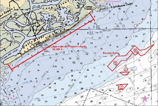
3 Environmental Assessment 1. Purpose and Need for this Document This Environmental Assessment (EA) represents the position of the US Army Corps of Engineers, Charleston District regarding the environmental impacts for the 2005 renourishment of Folly Island and has been prepared due to the change of the material borrow area for this nourishment cycle of the existing shore protection project. The April 1991 Environmental Assessment for the Folly Beach, South Carolina Shore Protection Project is incorporated in this document by reference and can be found in its entirety in Appendix 3. It is the purpose of this document to explain the design criteria for these changes. Only the subjects of the 1991 EA that need to be updated or are no longer valid are included in this document. All other findings from the 1991 EA are still valid. 2. Project Description a. Proposed Action. This is a periodic re-nourishment of an existing project. The recommended plan provides for re-nourishment of 28,200 linear feet (5.34 linear miles) of shoreline. A berm will be constructed with a top width of 15 feet and an elevation of 9.0 feet national geodetic vertical datum (NGVD). The project extends from just below the U.S. Coast Guard Base, and includes the Charleston County Park on the west end of Folly Island (See Figure 1). The exact quantity of sand that will be placed on the beach during re-nourishment will be dependent on the existing beach profile at the time of construction; however, based on present conditions, it is estimated that approximately two million cubic yards of beach quality sand will be placed on the beach seaward of existing revetments. The Federal government will not incur cost for any material placed on private property. Construction will be by means of a hydraulic cutter head dredge that will transport the sand through a pipeline. The pipeline will run parallel with the beach. Beach compatible material (for details see Appendix 2) from the offshore source will be pumped along the roughly 28,000 linear feet of the project and will be discharged as slurry. During construction, temporary training dikes of sand will be used to contain the discharge and control the fill placement. Fill sections will be graded by land-based equipment, such as bulldozers, articulated front-end loaders, and other equipment as necessary to achieve the desired beach profile. Equipment will be selected based on whatever proves to be the most advantageous economically, as well as what generates only minimal and acceptable temporary environmental impacts. It is anticipated construction will begin in mid-april 2005 and will require approximately 6 months for completion. This schedule could change due to contractual issues, inclement weather, equipment failure, or other unforeseen difficulties.
4 FIGURE 1: LOCATION OF NOURISHMENT AND BORROW AREAS The borrow areas being used for beach compatible sand are designated in Figure 1. These areas total 620 acres. The borrow areas are located approximately three miles offshore of the northern end of the island. None of the four borrow areas are inside any CBRA zones. The borrow areas have been surveyed by side-scan sonar, followed by the collection of numerous vibracore samples in each of the potential borrow sites. This was done in order to avoid hard/live bottom areas during dredging, and to ensure that adequate quantities of beach compatible sand were available in the three areas. Larger areas had been evaluated but the above listed acreages are what remained after the Corps of Engineers evaluation process. The location of the borrow sites has also been coordinated the South Carolina Department of Natural Resources. The volume of sand (based on dredging to a depth of 6 feet), area, and water depths in each borrow area are as follows: Borrow Area Volume (cubic yd) Area (acres) Water Depth A 3,130, B 2,030, C 320, D 400,
5 Sand will be removed from the borrow areas to a depth of 6 to 8 feet. Because of the dynamic nature of the coastal area and the constant movement of sand, it is expected that the borrow areas will fill with sand of the same grain size after the dredging has been completed. For a more comprehensive discussion of the geo-technical investigation, see Appendix Endangered Species Table 1 contains a list of threatened and endangered species that have been listed by the U.S. Fish and Wildlife Service as occurring or possibly occurring in Charleston County. Table 2 contains a list of threatened and endangered species in South Carolina under the jurisdiction of National Marine Fisheries Service (NMFS). 4. Coastal Barrier Resources System (CBRS) There are no areas within the project boundaries that coincide with the designated Coastal Barrier Resources System. 5. Environmental Consequences Mitigation Measures Temporary degradation of water quality will occur at both the dredging and the nourishment sites due to re-suspension of silt material. A temporary reduction of benthic populations in the borrow and beach fill areas will likely occur as well as a corresponding decline in photosynthesis. Since all aspects of the proposed work will occur either in the ocean or on the ocean beach, the project will not affect any listed species occurring in forested or freshwater habitats. Thus, species such as the bald eagle, red-cockaded woodpecker, wood stork, Bachman s Warbler, flatwoods salamander, Canby's dropwort, Pondberry, and Chaff-seed will not be affected by the proposed action. Species that could be present in the project area during the proposed action are the blue, finback, humpback, right, sei, and sperm whales. Also, the hawksbill, Kemp's ridley, leatherback, loggerhead, and green sea turtles could occur in the project area. However, loggerheads are the primary sea turtle nesters. The Florida manatee rarely visits the area but they do pass through when moving up the coast where they have been seen in various locations throughout South Carolina. The piping plover is an occasional visitor and winters adjacent to the area. There is no designated piping plover critical habitat within the project area; however, there is piping plover critical habitat on Bird Key Stono in Stono Inlet immediately south of Folly Island. The southern terminus of sea-beach amaranth range is Folly Island. However, there are currently no known populations that occur on the island.
6 TABLE 1: USF&WS THREATENED AND ENDANGERED SPECIES IN CHARLESTON COUNTY Common Name Scientific Name Status Occurrence West Indian manatee Trichechus manatus E Known Bald eagle Haliaeetus leucocephalus T Known Bachman s warbler Vermivora bachmanii E Known Wood stork Mycteria americana E Known Red-cockaded woodpecker Picoides borealis E Known Piping plover Charadrius melodus T/CH Known Kemp's ridley sea turtle Lepidochelys kempii* E Known Leatherback sea turtle Dermochelys coriacea* E Known Loggerhead sea turtle Caretta caretta T Known Green sea turtle Chelonia mydas* T Known Flatwoods salamander Ambystoma cingulatum T Known Shortnose sturgeon Acipenser brevirostrum* E Known Sea-beach amaranth Amaranthus pumilus T Known Pondberry Lindera melissifolia E Known Canby's dropwort Oxypolis canbyi E Possible Chaff-seed Schwalbea americana E Known Southern dusky salamander Desmognathus auriculatus SC Possible Gopher frog Rana capito SC Known Godfrey s privet Forestiera godfreyi SC Known Pondspice Litsea aestivalis SC Known Bachman s sparrow Aimophila aestivalis SC Possible Henslow s sparrow Ammodramus henslowii SC Known Red knot Calidris canutus SC Possible Swallow-tailed kite Elanoides forficatus forficatus SC Known American kestrel Falco sparverius SC Possible American oystercatcher Haematopus palliatus SC Known Loggerhead shrike Lanius ludovicianus SC Possible Swainson s warbler Limnothlypis swainsonii SC Known Painted bunting Passerina ciris ciris SC Possible Gull-billed tern Sterna nilotica SC Known Incised groovebur Agrimonia incisa SC Known Venus fly-trap Dionaea muscipula SC Known Southeastern myotis Myotis austroriparius SC Known Southern hognose snake Heterodon simus SC Known Angiosperm (no common name) Elytraria caroliniensis SC Known Creeping St. John s wort Hypericum adpressum SC Known Boykin s lobelia Lobelia boykinii SC Known Sweet pinesap Monotropsis odorata SC Known Savannah or Piedmont cowbane Oxypolis ternate SC Known Pineland plantain Plantago sparsiflora SC Known False coco Pteroglossaspis ecristata SC Known Awned meadowbeauty Rhexia aristosa SC Known Rafinesque s big-eared bat Corynorhinus rafinesquii SC Known Bull s Island white-tail deer Odocoileus virginianus SC Known Island glass lizard Ophisaurus compressus SC Known
7 TABLE 1: USF&WS THREATENED AND ENDANGERED SPECIES IN CHARLESTON COUNTY (CONT D) Common Name Scientific Status Occurrence Name Black-throated green warbler Dendroica virens SC Possible Black rail Laterallus jamai SC Possible Southern myotis Myotis austroriparius SC Known E: Federally endangered T: Federally threatened CH: Critical Habitat SC: Federal Species of Concern. These species are rare or limited in distribution but are not currently legally protected under the Endangered Species Act. Species proposed for listing: None Designated Critical Habitat: The U.S. Fish and Wildlife Service has designated critical habitat under the Endangered Species Act of 1973, as amended, for the piping plover (Charadrius melodus) on breeding grounds in the Great lakes and Northern Great Plains Regions, and in the wintering grounds along the coasts of North Carolina, South Carolina, Georgia, Florida, Alabama, Mississippi, Louisiana, and Texas. There is no designated piping plover critical habitat within the boundaries of the proposed project, however, there is piping plover critical habitat on Bird Key Stono in Stono Inlet immediately south of Folly Island. *Contact National Marine Fisheries Service for more information on this species. Consultation with the U.S. Fish and Wildlife Service (USFWS) concerning the effects of the proposed project on threatened and endangered species is ongoing. A Biological Assessment (BA) (see Appendix 1) has been prepared and forwarded to USFWS. The findings of the BA are that the proposed project is not likely to adversely affect any listed species or critical habitat except for the loggerhead sea turtle. Because of the potential effect of the proposed project on nesting sea turtles and/or hatchlings and their habitat, the finding of the BA is that there may be adverse affects to loggerhead sea turtles as a result of this project; however, the proposed project is not expected to jeopardize the continued existence of the species. As a result of the findings of the BA, the following precautions will be taken to minimize the effects to sea turtles:
8 TABLE 2: NATIONAL MARINE FISHERIES SERVICE THREATENED AND ENDANGERED SPECIES IN SOUTH CAROLINA Species Scientific Name Status Date Listed Listed Marine Mammals Blue whale Balaenoptera musculus E 12/02/70 Finback whale Balaenoptera physalus E 12/02/70 Humpback whale Megaptera novaeangliae E 12/02/70 Right whale Eubaleana glacialis E 12/02/70 Sei whale Balaenoptera borealis E 12/02/70 Sperm whale Physeter macrocephalus E 12/02/70 Listed Sea Turtles Green sea turtle Chelonia mydas T* 07/28/78 Hawksbill sea turtle Eretmochelys imbricata E 06/02/70 Kemp s ridley sea turtle Lepidochelys kempii E 12/02/70 Leatherback sea turtle Dermochelys coriacea E 06/02/70 Loggerhead sea turtle Caretta caretta T 07/28/78 Listed Fish Shortnose sturgeon Acipenser brevirostrum E 03/11/67 Species of Concern** Fish Dusky shark Carcharhinus obscurus Sand tiger shark Odontaspis taurus Night shark Carcharinus signatus Atlantic sturgeon Acipenser oxyrhynchus oxyrhynchus Speckled hind Epinephelus drummondhayi Warsaw grouper Epinephelus nigritus Goliath grouper Epinephelus itijara White marlin Tetrapturus albidus Species of Concern** Invertebrates Ivory bush coral Oculina varicosa Species proposed for listing: None Designated Critical Habitat: None in the area of this project Proposed Critical Habitat: None in the area of this project Candidate Species: None * Green turtles are listed as threatened, except for breeding populations of green turtles in Florida and on the Pacific Coast of Mexico, which are listed as endangered. ** Species of Concern are not protected under the Endangered Species Act, but concerns about their status indicate that they may warrant listing in the future. Federal agencies and the public are encouraged to consider these species during project planning so that future listings may be avoided.
9 During the sea turtle nesting season, the dredging contractor will provide nighttime monitoring along the beach where construction is taking place to ensure the safety of female turtles attempting to nest. A buffer zone around the female will be imposed in the event of an attempt to nest. If any construction of the project occurs during the period between May 1 and November 30, daily nesting surveys will be conducted starting either May 1 or 65 days prior to the start of construction, whichever is later. These surveys will be performed between sunrise and 9:00 A.M. and will continue until the end of the project, or September 30, whichever is earlier. Any nests found in the area that will be impacted by construction activities will be moved to a safe location. The nesting surveys and nest relocations will only be performed by people with a valid South Carolina DNR permit. If any construction of the project occurs during the period December 1 to April 30, no nesting surveys will be performed. For construction activities occurring during the period May 1 through November 30, staging areas for equipment and supplies will be located off of the beach to the maximum extent possible. For construction activities occurring during the period May 1 through November 30, all on-beach lighting associated with the project will be limited to the minimum amount necessary around active construction areas to satisfy Occupational Safety and Health Administration (OSHA) requirements. Immediately after completion of the project, the Corps of Engineers will till the newly constructed sand berm. The Corps of Engineers will also perform cone penetrometer testing of the nourished beach for 3 subsequent years, prior to May 1 of each year. If compaction testing shows sand compaction to be greater than 500 pounds per square inch (p.s.i.), the sand placed on the beach will be tilled. Visual surveys for escarpments along the Project area will be made continuously during project performance. Any escarpments greater than 18 inches in height extending for greater than 100 feet will be leveled. Inspection for escarpments will be repeated prior to May 1 for 3 subsequent years. Results of the surveys will be submitted to the USFWS prior to any action being taken. The USFWS will be contacted immediately if subsequent reformation of escarpments exceeding 18 inches in height for a distance of 100 feet occurs during nesting and hatching season. This coordination will determine what appropriate action must be taken. An annual summary of escarpment surveys and action taken will be submitted to the USFWS. Adherence to the above precautions should minimize the effects to nesting loggerhead sea turtles and emerging loggerhead sea turtle hatchlings. The monitoring and relocation program will minimize potential adverse affects to nesting sea turtles. Completion of the
10 project will recreate lost habitat and protect existing turtle nesting habitat as well as the structures on the island. 6. Essential Fish Habitat The content of this section was coordinated with National Marine Fisheries Service representative Prescott Brownell. Our current determination is that the proposed action would not have a substantial individual or cumulative adverse impact on EFH or fisheries managed by the South Atlantic Fishery Management Council and the NMFS. EFH Assessment 1) Description of the site: Folly Island is a coastal barrier island, characteristic of the sea island coastal region of South Carolina and Georgia, and is surrounded by sensitive coastal marine and estuarine habitats. Coastal barrier beaches, near-shore waters, inlets, and associated estuarine tidal wetlands provide high quality feeding, cover, spawning, and maturation sites for a variety of living marine resources. As such any component of the project that may directly or indirectly reduce the quality, aerial extent, or natural character of the habitats involved should be identified. The project site is located in areas identified as Essential Fish Habitat (EFH) in the 1998 Amendment to Fishery Management Plans (FMP) that was prepared by the South Atlantic Fishery Management Council (SAFMC). This Amendment was prepared in accordance with the Magnuson-Stevens Fishery Conservation and Management Act (MSFCMA) of 1996 (P.L ) and was approved by the Secretary of Commerce on June 3, Detailed information regarding EFH and species managed by the SAFMC can be found in the amended FMPs. EFH at the project site includes coastal marine unconsolidated sand/mud bottoms. (This description was furnished by NMFS) 2) The primary borrow area for this project is a large area covering 310 acres off the Northeast coast of Folly Island (see Figure 1). It has been surveyed by side-scan sonar, followed by the taking of numerous Vibracore samples in both potential borrow sites. This was done in order to avoid hard bottom areas during dredging, and adequate depths of sand were found to be in the core of the two areas. In addition to our own internal review where we looked for shallow depth of borings (hard bottom), deep sand deposits, and the presence of organic materials in the sample, the SC DNR also reviewed the reports and findings and helped to outline those areas that should be avoided. Because of the dynamic nature of the coastal area and the constant movement of sand, it is expected that the borrow area will fill with sand of the same grain size or slightly smaller after the pumping has been completed. The secondary borrow area for this project is a 210 acre area adjacent to the primary borrow area (also see Figure 1). The same type of survey work was done on this site and the SC DNR also helped to eliminate those areas that might contain live bottom.
11 Both borrow area acreages have been adjusted to match the amount of suitable sand depth. Larger areas had been evaluated but the above listed acreages are what remained after the Corps of Engineers and SC Department of Natural Resources review and evaluation process. Monitoring of sand borrow sites is normally conducted to determine recovery rates and ecological characteristics. The customary detailed post-dredging assessment of bathymetry and biological characteristics in the borrow area will be needed for this project, even though deep depressions will not be made. Due to the large volume of sand required for this effort being drawn from a broad area(s), and the fact that there may be another cycle of dredging in the future, it was determined by the National Marine Fisheries Service that the detailed postdredging assessment should be implemented. 3) A description of the proposed action is located in Section II above. 4) Analysis of individual and cumulative effects on EFH: Federally managed species associated with the above-mentioned habitats found at the project site include postlarval, juvenile, and adult red drum (Sciaenops ocellata), white shrimp (Litopenaeus setiferus), and brown shrimp (Farfantepenaeus aztecus). Species under jurisdiction of the Mid Atlantic Fishery Management Council also occur in the project area. These species and their associated EFH include juvenile and adult summer flounder (Paralichthys dentatus) which occur on submerged estuarine bottom and in the water column, and juvenile and adult bluefish (Pomatomus saltatrix) which occur in the water column. The project area also provides nursery and forage habitat for other species including black drum (Pogonias cromis), Atlantic menhaden (Brevoortia tyrannus), and blue crab (Callinectes sapidus) which serve as prey for other species (e.g., mackerels, snappers, and groupers) that are managed by the SAFMC, and for highly migratory species (e.g. billfishes and sharks) that are managed by the NMFS. Macro invertebrate inhabitants of the near shore coastal zone are important components of coastal marine food webs and serve as prey for the aforementioned federally managed fishes. Characteristic benthic fauna of southeastern beaches is diverse, including tropically important representatives such as haustoriid amphipods, polychaete worms, isopods, and ghost crab (Ocypode quadrata). 5) Charleston District s views regarding effects: Based on project reviews provided by the National Marine Fisheries Service and the South Carolina Department of Natural Resources to the Charleston District, significant long-term harm to the ecologically diverse aquatic habitats, such as live rock and other stable bottoms are not anticipated. Although non-motile benthic animals will be adversely affected by placement of sand, re-colonization is expected to be relatively rapid, with reestablishment of the beach zone community within 1-2 years in affected areas. Areas to be affected by excavation of beach quality sand include up to approximately 520 acres. Within sand borrow areas; benthic epifauna and infauna will be impacted by excavation and temporary turbidity that may extend beyond the excavation areas.
12 The majority of the sand would be drawn from the primary borrow site. Sand would be shaved off in layers until the required volumes were met, but the excavation would go no deeper than 5 to 10 feet. If additional material is needed, it will be removed from the secondary site. Both areas have been carefully mapped out to avoid live/hard bottom, and no deep depressions will be created in the borrow areas. Upon completion of the work, inter-tidal and sub-tidal zone on the beach will be covered with sand. Materials used for beach nourishment may also be transported by natural processes onto other areas that support benthic communities; however, no hard bottoms or vegetated wetlands will be affected. Other potential impacts include localized turbidity elevation and possible reduction of dissolved oxygen in the surrounding water column. Elevated turbidity can reduce photosynthesis activity of pelagic and benthic algae. Suspended sediments can cause physical damage to respiratory structures of early life history stages of fishes and invertebrates. 6) Proposed mitigation, if applicable: Not applicable in this case. 7. Cultural Resources The South Carolina Institute of Archaeology and Anthropology (SCIAA) has pointed out, via letter of October 13, 2004, that there is a possibility of shipwrecks residing in the proposed borrow areas. Similar concerns were expressed by the State Historic Preservation Office (SHPO). These areas are being surveyed for the presence of any significant cultural resources. The findings of the survey will be coordinated with SCIAA and SHPO in order to protect the resource from possible harm during the dredging process. 8. Water Quality Certification A modification to the water quality certification associated with this project is required due to the change of the borrow site location. The South Carolina Department of Environmental Health and Control does not require a specific public notice to initiate the modification. In lieu of a specific Section 404 public notice, letters were sent to all pertinent agencies and interests describing the proposed project and seeking their input. As a result of this letter request and phone conversations with SC Department of Health and Environmental Control, no difficulties are anticipated in granting the water quality certification and it is expected on or before February 8, The original WQ certification was granted under P/N 91-2R Coastal Consistency In a letter dated January 25, 2005 the Office of Ocean and Coastal Resource Management concurred with the Charleston District that this Federal Action was consistent with the Coastal Zone Management Act.
13
14 404(b)(1) Evaluation Folly Beach Shore Protection Charleston County South Carolina I. PROJECT DESCRIPTION a. Location and General Description. Folly Beach is located on Folly Island about six miles South of the Charleston Harbor Entrance (see Figure 1) and is bounded by Morris Island to the north, Kiawah Island to the south, James Island to the west, and to the east is the Atlantic Ocean. The island is six miles long, one-half mile wide, and is oriented northeast to southwest. The Town of Folly Beach lies in the middle of the island between the former U.S. Coast Guard Loran Station to the northeast and the Charleston County Park to the southwest. South Carolina Route 171 crosses the marsh between James Island and Folly Island and provides the only highway access to Folly Beach. This is an emergency re-nourishment combined with a periodic re-nourishment of an existing project. The recommended plan provides for re- nourishment of 28,200 linear feet (5.34 linear miles) of shoreline. A berm will be constructed with a top width of 15 feet and an elevation of 9.0 feet national geodetic vertical datum (NGVD). The project extends from just below the U.S. Coast Guard Base, and includes the Charleston County Park on the west end of Folly Island (See Figure 2). The exact quantity of sand that will be placed on the beach during re- nourishment will be dependent on the existing beach profile at the time of construction; however, based on present conditions, it is estimated that approximately 2 million cubic yards of beach quality sand will be placed on the beach seaward of existing revetments. The Federal government will not incur cost for any material placed on private property. Construction will be by means of a hydraulic cutter head dredge that will transport the sand through a pipeline. The pipeline will run parallel with the beach. Beach compatible material (sand) from the offshore source will be pumped along the roughly 28,200 linear feet of the project and will be discharged as slurry. During construction, temporary training dikes of sand will be used to contain the discharge and control the fill placement. Fill sections will be graded by land-based equipment, such as bulldozers, articulated front-end loaders, and other equipment as necessary to achieve the desired beach profile. Equipment will be selected based on whatever proves to be the most advantageous economically, as well as what generates only minimal and acceptable temporary environmental impacts. It is anticipated construction will begin in mid-april 2005 and will require approximately 6 months for completion. This schedule could change due to contractual issues, inclement weather, equipment failure, or other unforeseen difficulties. b. Authority and Purpose. The Folly Beach re-nourishment project study was initially begun under the original project authority, Section 501 of the Water Resources Development Act of However, due to the extent of the storm damage from the 2004 hurricane season, it was combined with the authority of PL
15 A final Environmental Impact Statement (including a 404(b) evaluation) for Beach Erosion Control and Hurricane Protection for Folly Beach, South Carolina was filed with CEQ on July 11, 1980, coordinated with other agencies and circulated for public review and comment. A subsequent EA and 404(b) evaluation was executed on April 25, A second EA has been prepared for the present emergency re-nourishment project. c. General Description and Quantities of the Dredged or Fill Material. The borrow areas proposed for dredging are sand accumulation areas noted as A, B, C, & D in Figure 2. These areas total 620 acres, however, only areas A and B are going to be used for this nourishment effort since 2,000,000 cubic yards are needed to be pumped on the beach. The borrow areas are located approximately three miles offshore of the northern end of the island. None of the four borrow areas are inside any CBRA zones. The borrow areas have been surveyed by side-scan sonar, followed by the collection of numerous vibracore samples in each of the potential borrow sites. This was done in order to avoid hard/live bottom areas during dredging, and to ensure that adequate quantities of beach compatible sand were available in the four areas. Larger areas had been evaluated but the above listed acreages are what remained after the Corps of Engineers evaluation process. The location of the borrow sites has also been coordinated with the South Carolina Department of Natural Resources. The volume of beach compatible sand (based on dredging to a depth of 6 feet), area, and water depths in each borrow area are as follows: Borrow Area Volume (cubic yd) Area (acres) Water Depth A 3,130, B 2,030, C 320, D 400, Sand will be removed from the borrow areas to a depth of 6 to 8 feet. Because of the dynamic nature of the coastal area and the constant movement of sand. It is expected that the borrow areas will fill with sand of the same grain size after the dredging has been completed. d. Description of the Proposed Discharge Site(s). The beach compatible material will be placed on the ocean shoreline along Folly Island for a length of 28,200 feet or 5.34 miles, extending from Station South to Station North, as shown on Figure 1. e. Description of Disposal Method. The material will be excavated by either a hydraulic cutter head dredge or a hopper dredge, either of which will transport the sand through a pipeline, as described in I. a. above. II. FACTUAL DETERMINATIONS a. Physical Substrate Determinations. (1) Substrate Evaluation and Slope. The elevations of the developed portion of Folly Island range from 5 to 14 feet NGVD. The four borrow areas cover 620 acres and are approximately 3 miles offshore; with areas A and B within the 3-mile limit,
16 and areas C and D are outside the 3-mile limit (see FIGURE 2). Only areas A and B are being utilized for this renourishment effort. (2) Sediment Type. Site A This site is approximately 310 acres and has 3,130,000 cubic yards of beach compatible sand available in 2 to 10 foot depths. There were a total of 19 vibracores done in this area in 2003 and 2004, 2 of which are shared with the Site B border. Site B This site is approximately 210 acres and has 2,030,000 cubic yards of beach compatible sand available in 2 to 10 foot depths. There were a total of 14 vibracores done in this area in 2003 and 2004, 2 of which are shared with the Site A border. Site C This site is approximately 30 acres and has 320,000 cubic yards of beach compatible sand available in 4 to 6 foot depths. There were a total of 5 vibracores done in this area in 2003 and Site D This site is approximately 70 acres and has 400,000 cubic yards of beach compatible sand available in 4 to 6 foot depths. There were a total of 7 vibracores done in this area in 2003 and Summary of Sites A through D No hard bottom was found during this site investigation within any of the proposed borrow areas. Cemented sands and/or limestone were encountered in some of the vibracore samples; however, those vibracores were not included in areas designated as borrow areas. In general, the sands located in all four borrow areas are coarser than the native beach sands due to a larger fraction of shells than contained on the beach. The coarser portion of the grain size distribution is typically a coarse sand and fine gravel fraction. The borrow area sands are typically more calcareous than the native beach sands. The silt and clay fraction in the proposed borrow areas was limited to approximately 10%, and much of that will be lost during excavation and placement operations. Sites C and D will not be used during this nourishment cycle. (3) Dredged/Fill Material Movement. The material will be pumped as a slurry and shaped using land based equipment and training dikes. Some material, particularly any fine-grained sediments will be lost in the surf, but the majority of the material will remain on the island. (4) Physical Effects on Benthos. Benthic organisms in the vicinity of the construction, either dredging or placement, will be impacted by the construction. However, the construction is temporary, and it is expected that organisms will recolonize the disturbed areas following construction activities.
17 (5) Actions Taken to Minimize Impacts. The amount of material removed from the borrow sites will only be that quantity necessary to accomplish the project, thereby minimizing impacts to the greatest extent possible. b. Water Circulation, Fluctuation and Salinity Determinations. (1) Water. (a) Salinity. This activity will occur in the open ocean and on an adjacent beach. Construction will have no impact on salinity. (b) Water Chemistry. Temporary changes in water chemistry related to increased turbidity levels at the construction site may occur. Impacts would be temporary and minimal in nature. (c) Clarity and Color. The water may become temporarily cloudy at the construction site during construction activity due to increased turbidity levels associated with disturbance of sediments. As noted above, this is expected to return to normal levels shortly after construction ends. (d) Odor. Construction activities may result in a release of hydrogen sulfide (rotten egg) odor from the disturbance of sediments. This should be minimal, will be a temporary impact and will not result in long-term effects. (e) Taste. Not applicable. (f) Dissolved Gas Levels. There may be minor impacts to dissolved oxygen levels as a result of increased turbidity levels. These would be similar to any dredging project, and the impacts will be localized and temporary. (g) Nutrients. No impacts to nutrient loading at the dredging site or on the beach are expected to occur. (h) Eutrophication. Not applicable. (2) Current Patterns and Circulation. (a) Current Patterns and Flow. This project will not change present current patterns or flow in or around Folly Island. (b) Velocity. Not applicable. (c) Stratification. Not applicable.
18 (d) Hydrologic Regime. This project will not change the present hydrologic regime. (3) Normal Water Level Fluctuations. Water level will not change, but the increased beach elevations will provide protection to existing structures on the beach. (4) Salinity Gradients. Salinity gradients will not change. (5) Actions That Will Be Taken to Minimize Impacts. There are no actions needed since there are not measurable impacts to current patterns and circulation. c. Suspended Particulate/Turbidity Determinations. (1) Expected Changes in Suspended Particulates and Turbidity Levels in the Vicinity of the Disposal Site. Turbidity will increase during construction/disposal operations, but will return to normal levels when construction is complete. (2) Effects (degree and duration) on Chemical and Physical Properties of the Water Column. (a) Light Penetration. During construction, light penetration at the disposal site may diminish slightly due to a temporary increase in turbidity levels. Light penetration will return to normal levels following construction. (b) Dissolved Oxygen. Dissolved oxygen (DO) levels may decrease during construction at the disposal site as a result of increased turbidity. However, this decrease will be minimal due to the dynamic characteristics of the ocean, and DO levels should return to normal conditions immediately following construction. (c) Toxic Metals and Organics. Not applicable. (d) Pathogens. Not applicable. (e) Aesthetics. During construction, there would be an increase in the ambient noise levels, which will return to normal levels following construction. In addition, construction activity on the beach obstructs the visual aesthetic of the ocean, but it is a temporary effect, which will also return to normal immediately following construction. (3) Effects on Biota. (a) Primary Production & Photosynthesis. Although there will be some turbidity at the construction site, it is not expected that measurable impacts
19 to primary production and photosynthesis will occur since the area of impact is small. (b) Suspension/Filter Feeders. Temporary impacts would include increased turbidity, which may reduce oxygen levels and impact food intake to organisms at the construction site. However, water clarity and dissolved oxygen concentrations will improve following construction. (c) Sight Feeders. A minimal, temporary disruption due to construction disturbances is possible. A rapid recovery is expected since most sight feeders are transient and can relocate until construction activities are complete. (4) Actions taken to Minimize Impacts. The above noted impacts are temporary and conditions should improve following construction. It is unlikely that further minimization in these areas is possible. d. Contaminant Determinations. The borrow sites have been tested for grain size analysis and are predominantly sand. No further testing is required since contaminants would not be associated with the sandy substrates. e. Aquatic Ecosystem and Organism Determinations. (1) Effects on Plankton. Effects on plankton would be related to turbidity associated with the construction activity. Effects would be minor and temporary in duration. (2) Effects on Benthos. Benthic activity at the construction site would be impacted as bottom sediments are disturbed or placed on the beach. These disturbances will be temporary and recolonization on the beach will occur following construction. (3) Effects on Nekton. Not significant. (4) Effects on Aquatic Food Web. Not significant. (5) Effects on Special Aquatic Sites. (a) Sanctuaries and Refuges. Not applicable. (b) Wetlands. Not applicable. (c) Mud Flats. Not applicable. (d) Vegetated Shallows. Not applicable.
20 (e) Coral Reefs. Not applicable. (f) Riffle and Pool Complexes. Not applicable. (6) Threatened and Endangered Species. Although there are known threatened or endangered species within the project area, the potential impacts have been addressed in the environmental assessment and coordinated with pertinent state and Federal agencies. Subsequently, unacceptable adverse impacts to threatened or endangered species are not anticipated or expected. (7) Other Wildlife. A wide variety of wildlife - birds, mammals, reptiles and amphibians - utilize the beach and ocean. Impacts to wildlife in the project area would be associated with the construction activities. Wildlife would be expected to leave the area during construction, but would return when construction is complete. (8) Actions to Minimize Impacts. Plans and specs for the project specify requirements to ensure impacts to the environment are minimized or avoided. f. Proposed Disposal Site Determinations. (1) Mixing Zone Determination. Not applicable. The State of South Carolina Department of Health and Environmental Control (SCDHEC) does not recognize mixing zones. (2) Determination of Compliance with Applicable Water Quality Standards. Section 401 Water Quality Certification has not been issued yet by SCDHEC, however, they have stated that it will be issued as a MOD to the existing certification for this project. OCRM, on the other hand, will need to issue a new coastal consistency statement. (3) Potential Effects on Human Use Characteristics. (a) Municipal and Private Water Supply. Not applicable. (b) Recreational and Commercial Fisheries. The presence of the dredge and the pipeline may cause commercial or recreational fisherman and commercial shrimpers to utilize different routes or fishing locations since the pipeline will extend perpendicular to the coast for a distance of 3 miles. However, this should result in minimal, temporary impacts to the fishery. (c) Water Related Recreation. Water related recreational activities may be limited on the beach and in the waters adjacent to the beach due to the presence of the pipeline and equipment. These limitations will move along the beach as the construction activity advances.
21 (d) Aesthetics. The construction activity will have a negative impact on visual and audible aesthetics. However, the activity will move relatively rapidly down the beach, so no one area will endure the aesthetic impacts for long. (e) Parks, National and Historical Monuments, National Seashores, Wilderness Areas, Research Sites, and Similar Preserves. Beach and water related recreational activities may be temporarily limited due to the presence of the pipeline and equipment. These limitations will pass through and move along the portion of the beach fronting the park area as the construction activity advances. g. Determination of Secondary and Cumulative Efects on the Aquatic Ecosystem. Initial negative effects related to this project include those associated with turbidity, impacts to the benthic community, and aesthetics. These effects are considered temporary. Long-term, permanent effects will provide for the restoration of a dune system which will provide storm damage protection of structures on the island. The beneficial permanent effects outweigh the negative temporary effects associated with the construction activity. III. FINDINGS OF COMPLIANCE OR NON-COMPLIANCE WITH THE RESTRICTIONS ON DISCHARGE. a. No significant adaptations of the guidelines were made relative to this evaluation. b. Alternatives that were considered were included in the 1991 EA. The currently proposed project is not the result of a new analysis, but rather the re-creation of the selected alternative derived from the analysis done for the original project, while using new borrow sites. c. The proposed construction described in this evaluation would not cause or contribute to violations of any known applicable state water quality standards, which would result in permanent damage to the ecosystem. d. The proposed project will not violate the Endangered Species Act of e. The proposed project will not violate any specified protection measures for marine sanctuaries designated by the Marine Protection, Research, and Sanctuaries Act of f. The proposed project will not result in significant adverse affects on human health and welfare in regard to municipal and private water supplies, recreation and commercial fishing, plankton, fish, shellfish, wildlife, and special aquatic sites. The life states of aquatic life and other wildlife will not be adversely affected. Significant adverse affects on aquatic ecosystem diversity, productivity and stability, and recreational, aesthetic and economic values will not occur.
22
23
24 FIGURE 2
25 Appendix 1 Biological Assessment
26 BIOLOGICAL ASSESSMENT OF THE PROPOSED FOLLY BEACH STORM DAMAGE REDUCTION RE-NOURISHMENT PROJECT FOLLY BEACH, SOUTH CAROLINA SEPTEMBER INTRODUCTION Folly Beach is located on the South Carolina coast in Charleston County, approximately 12 miles south of the downtown area of the City of Charleston and 9 miles southwest of Sullivan s Island (see Figure 1). The 6-mile long island reaches from the confluence of the Stono and Folly Rivers at the west end to Lighthouse Creek at the east end. The Folly Beach Storm Damage Reduction project is being conducted under authority of the Water Resources Development Act (WRDA) of 1986 (P.L ). An amendment to the previous environmental assessment (EA) is being prepared to evaluate the overall environmental impacts of the proposed project due to the proposed use of an offshore material borrow site. This document re-evaluates the impact of the proposed project on threatened and endangered species and will be incorporated in the amendment to the EA. The purpose of this project is to protect the economic resources located on Folly Island from erosion and storm events, with a secondary benefit of providing additional beach and dune area that will facilitate sea turtle nesting, as well as providing habitat for the Wilson s plover and least tern. The majority of Folly Island is developed in the manner of a typical suburban municipality and is a mix of residential and commercial properties. The commerce of the island is primarily associated with the tourism industry. The southern end of Folly Island is designated as a Charleston County Park. 2.0 PROPOSED PROJECT DESCRIPTION This is a periodic nourishment of an existing project. The recommended plan provides for nourishment of 28,200 linear feet (5.34 linear miles) of shoreline. A berm will be constructed with a top width of 15 feet and an elevation of 9.0 feet national geodetic vertical datum (NGVD). The project extends from just below the U.S. Coast Guard Base and extends to the Charleston County Park on the west end of Folly Island (see Figure 2). The exact quantity of sand that will be placed on the beach during re-nourishment will be dependent on the existing beach profile at the time of construction; however, based on expected erosion rates, it is estimated that 1.7 million cubic yards of beach quality sand will be placed on the beach. Construction will be by means of either a hydraulic cutterhead dredge or a hopper dredge that will transport the sand through a pipeline. The pipeline will run parallel with the beach. Beach compatible material (sand) from the off-shore source will be pumped along the roughly 28,000 linear feet reach of the project and will be discharged as a slurry. During construction,

27 FIGURE 1: LOCATION OF FOLLY BEACH
28 FIGURE 2: FOLLY BEACH PROJECT LIMIITS
29 temporary training dikes of sand will be used to contain the discharge and control the fill placement. Fill sections will be graded by land-based equipment, such as bulldozers, articulated front-end loaders, and other equipment as necessary to achieve the desired beach profile. It is anticipated that construction will begin in late-2005 (i.e., November or December) and will require approximately 6 to 8 months for completion. This construction window should minimize impacts to sea turtles, fish, shellfish, and infauna. This schedule could change due to funding constraints, contractual issues, inclement weather, equipment failure, or other unforeseen difficulties. The borrow areas being used for beach compatible sand are designated in Figure 2. These areas total approximately 620 acres. The borrow areas are located approximately three miles off-shore of the northern end of the island. None of the three borrow areas are inside any CBRA zones. The borrow areas have been surveyed by side-scan sonar, followed by the collection of numerous vibracore samples in each of the potential borrow sites. This was done in order to avoid hard/live bottom areas during dredging, and to ensure that adequate quantities of beach compatible sand were available in the three areas. Larger areas had been evaluated but the above listed acreages are what remained after the Corps of Engineers evaluation process. The location of the borrow sites will be coordinated with South Carolina Department of Natural Resources (SCDNR). The size, sand volume (based on dredging to a depth of 6 feet), and water depth of each borrow area are as follows: Borrow Area Area Volume (acres) (cu. yd.) A ~310 3,130, Water Depth (ft.) B ~210 2,030, C ~30 320, D ~70 400, Sand will be removed from the borrow areas to a depth of 6 to 8 feet. Because of the dynamic nature of the coastal area and the constant movement of sand, it is expected that the borrow areas will fill with sand of the same grain size after the dredging has been completed. PRIOR CONSULTATIONS Previous Section 7 formal or informal consultations occurred in support of the 1991 Environmental Assessment and the 1980 Environmental Impact Statement that were prepared for the original Folly Beach nourishment project. 4
30 3.0 LIST OF SPECIES Table 1 contains a list of species that have been listed by the U.S. Fish and Wildlife Service as occurring or possibly occurring in Charleston County. Table 2 contains a list of threatened and endangered species in South Carolina under the jurisdiction of NOAA Fisheries. 4.0 GENERAL EFFECTS ON LISTED SPECIES/CRITCAL HABITAT Since all aspects of the proposed work will occur either in the ocean or on the ocean beach, the project will not affect any listed species occurring in forested or freshwater habitats. Thus, species such as the bald eagle, red-cockaded woodpecker, wood stork, Bachman s warbler, flatwoods salamander, Canby's dropwort, pondberry, and chaff-seed will not be affected by the proposed action. Species that could be present in the project area during the proposed action are the blue, finback, humpback, right, sei, and sperm whales. Also, the hawksbill, Kemp's ridley, leatherback, loggerhead, and green sea turtles could occur in the project area. However, loggerheads are the primary sea turtle nesters. The Florida manatee rarely visits the area but they do pass through when moving up the coast where they have been seen in various locations throughout South Carolina. The piping plover is an occasional visitor and winters adjacent to the area. There is no designated piping plover critical habitat within the project area; however, there is piping plover critical habitat on Bird Key Stono in Stono Inlet immediately south of Folly Island (see Figure 3). The southern terminus of sea-beach amaranth range is Folly Island. However, there are currently no known populations that occur on the island. 5.0 SPECIES ASSESSMENTS 5.1 Blue, finback, humpback, right, sei, and sperm whales The blue whale may be the largest mammal ever to inhabit the earth. It may reach lengths of up to 100 feet roughly the length of a basketball court. Blue whales weigh up to 160 tons. They feed on small shrimp-like crustaceans. The whales consume up to eight tons of these animals a day during their feeding period. A blue whale produced the loudest sound ever recorded from an animal, and some scientists have speculated that they may be able to remain in touch with each other over hundreds of miles. The number of blue whales in the southern hemisphere was severely depleted by whaling. Due to commercial whaling the size of the population is less than ten percent of what it was originally. The finback whale is the second largest whale, reaching lengths of up to 88 feet and weighing up to 76 tons. The finback whale because of its crescent-shaped dorsal fin, and obvious characteristic, is easily seen at sea. Depending on where they live, finback whales eat both fish and small pelagic crustaceans, and squids. It sometimes leaps clear of the water surface, yet it is 5
31 TABLE 1: USF&WS THREATENED AND ENDANGERED SPECIES IN CHARLESTON COUNTY Common Name Scientific Name Status Occurrence West Indian manatee Trichechus manatus E Known Bald eagle Haliaeetus leucocephalus T Known Bachman s warbler Vermivora bachmanii E Known Wood stork Mycteria americana E Known Red-cockaded woodpecker Picoides borealis E Known Piping plover Charadrius melodus T/CH Known Kemp's ridley sea turtle Lepidochelys kempii* E Known Leatherback sea turtle Dermochelys coriacea* E Known Loggerhead sea turtle Caretta caretta T Known Green sea turtle Chelonia mydas* T Known Flatwoods salamander Ambystoma cingulatum T Known Shortnose sturgeon Acipenser brevirostrum* E Known Sea-beach amaranth Amaranthus pumilus T Known Pondberry Lindera melissifolia E Known Canby's dropwort Oxypolis canbyi E Possible Chaff-seed Schwalbea americana E Known Southern dusky salamander Desmognathus auriculatus SC Possible Gopher frog Rana capito SC Known Godfrey s privet Forestiera godfreyi SC Known Pondspice Litsea aestivalis SC Known Bachman s sparrow Aimophila aestivalis SC Possible Henslow s sparrow Ammodramus henslowii SC Known Red knot Calidris canutus SC Possible Swallow-tailed kite Elanoides forficatus forficatus SC Known American kestrel Falco sparverius SC Possible American oystercatcher Haematopus palliatus SC Known Loggerhead shrike Lanius ludovicianus SC Possible Swainson s warbler Limnothlypis swainsonii SC Known Painted bunting Passerina ciris ciris SC Possible Gull-billed tern Sterna nilotica SC Known Incised groovebur Agrimonia incisa SC Known Venus fly-trap Dionaea muscipula SC Known Southeastern myotis Myotis austroriparius SC Known Southern hognose snake Heterodon simus SC Known Angiosperm (no common name) Elytraria caroliniensis SC Known Creeping St. John s wort Hypericum adpressum SC Known Boykin s lobelia Lobelia boykinii SC Known Sweet pinesap Monotropsis odorata SC Known Savannah or Piedmont cowbane Oxypolis ternate SC Known Pineland plantain Plantago sparsiflora SC Known False coco Pteroglossaspis ecristata SC Known Awned meadowbeauty Rhexia aristosa SC Known Rafinesque s big-eared bat Corynorhinus rafinesquii SC Known Bull s Island white-tail deer Odocoileus virginianus SC Known Island glass lizard Ophisaurus compressus SC Known 6
32 TABLE 1: USF&WS THREATENED AND ENDANGERED SPECIES IN CHARLESTON COUNTY (CONT D) Common Name Scientific Name Status Occurrence Black-throated green warbler Dendroica virens SC Possible Black rail Laterallus jamai SC Possible Southern myotis Myotis austroriparius SC Known E: Federally endangered T: Federally threatened CH: Critical Habitat SC: Federal Species of Concern. These species are rare or limited in distribution but are not currently legally protected under the Endangered Species Act. Species proposed for listing: None Designated Critical Habitat: The U.S. Fish and Wildlife Service has designated critical habitat under the Endangered Species Act of 1973, as amended, for the piping plover (Charadrius melodus) on breeding grounds in the Great lakes and Northern Great Plains Regions, and in the wintering grounds along the coasts of North Carolina, South Carolina, Georgia, Florida, Alabama, Mississippi, Louisiana, and Texas. There is no designated piping plover critical habitat within the boundaries of the proposed project, however, there is piping plover critical habitat on Bird Key Stono in Stono Inlet immediately south of Folly Island (see Figure 3). * Contact NOAA Fisheries for more information on this species. also a deeper diver than some of the other baleen whales. The finback's range is in the Atlantic from the Arctic Circle to the Greater Antilles, including the Gulf of Mexico. In the Pacific Ocean the Finback ranges from the Bering Sea to Cape San Lucas, Baja California. The humpback whale reaches a maximum length of about 50 feet and a maximum weight of about 37½ tons. They are mostly black, but the belly is sometimes white. Flippers and undersides of the flukes are nearly all white. They are migratory. They eat krill and schooling fish. In the Atlantic they migrate from Northern Iceland and Western Greenland south to the West Indies, including the Northern and Eastern Gulf of Mexico. In the Pacific Ocean they migrate from the Bering Sea to Southern Mexico. The humpback is one of the most popular whales for whale watching on both the east and west coasts. Scientists estimate that there are 10,000 humpbacks worldwide, only about 8% of its estimated initial population. The sei whale is one of the largest whales. It can reach a length of 60 feet and a weight of 32 tons. They feed primarily on krill and other small crustaceans, but also feed at times on small fish. The sei whale is the fastest of the baleen whales and can reach speeds of more than 20 miles per hour. In the Atlantic Ocean the Sei whale ranges from the Arctic Circle to the Gulf of Mexico. In the Pacific Ocean the Sei whale may range from the Bering Sea to Southern Mexico. The Sei whale is endangered due to past commercial whaling. 7
33 TABLE 2: NOAA FISHERIES THREATENED AND ENDANGERED SPECIES IN SOUTH CAROLINA Species Scientific Name Status Date Listed Listed Marine Mammals Blue whale Balaenoptera musculus E 12/02/70 Finback whale Balaenoptera physalus E 12/02/70 Humpback whale Megaptera novaeangliae E 12/02/70 Right whale Eubaleana glacialis E 12/02/70 Sei whale Balaenoptera borealis E 12/02/70 Sperm whale Physeter macrocephalus E 12/02/70 Listed Sea Turtles Green sea turtle Chelonia mydas T* 07/28/78 Hawksbill sea turtle Eretmochelys imbricata E 06/02/70 Kemp s ridley sea turtle Lepidochelys kempii E 12/02/70 Leatherback sea turtle Dermochelys coriacea E 06/02/70 Loggerhead sea turtle Caretta caretta T 07/28/78 Listed Fish Shortnose sturgeon Acipenser brevirostrum E 03/11/67 Species of Concern** Fish Dusky shark Carcharhinus obscurus Sand tiger shark Odontaspis taurus Night shark Carcharinus signatus Atlantic sturgeon Acipenser oxyrhynchus oxyrhynchus Speckled hind Epinephelus drummondhayi Warsaw grouper Epinephelus nigritus Goliath grouper Epinephelus itijara White marlin Tetrapturus albidus Species of Concern** Invertebrates Ivory bush coral Oculina varicosa Species proposed for listing: None Designated Critical Habitat: None in the area of this project Proposed Critical Habitat: None in the area of this project Candidate Species: None * Green turtles are listed as threatened, except for breeding populations of green turtles in Florida and on the Pacific Coast of Mexico, which are listed as endangered. ** Species of Concern are not protected under the Endangered Species Act, but concerns about their status indicate that they may warrant listing in the future. Federal agencies and the public are encouraged to consider these species during project planning so that future listings may be avoided. 8

34 FIGURE 3: PIPING PLOVER CRITICAL HABITAT IN STONO INLET Unlike the other great whales on the endangered species list, the sperm whale is a toothed whale. It is the largest of the toothed whales reaching a length of 60 feet in males and 40 feet in females. Sperm whales are noted for their dives that can last up to an hour and a half and go as deep as 2 miles under the surface. It is the most abundant of all the endangered whales, with an estimated population of two million. Sperm whales feed mainly on squid, including the giant squid. They range in the Atlantic Ocean from the Arctic Circle to the Gulf of Mexico. In the Pacific Ocean the sperm whale ranges from the Bering Sea to Southern Mexico. The sperm whale was almost hunted to extinction for its oil (spermaceti). This oil was used in the manufacture of ointments, cosmetics, and candles. The sperm whales usually inhabit the offshore waters. 9
35 The right whale is the most endangered species of whale off of the U.S. coasts. The right whale got its name because it was the "right" whale to hunt. It was slow moving and floated after being killed. Current estimates indicate that presently no more than a few hundred exist. Right whales can reach a length of 60 feet and a weight of 100 tons. Although the species has been internationally protected since 1937, it has failed to show any signs of recovery. Right whales have been observed along the eastern coast of North America from the Florida Keys north to the Gulf of St. Lawrence in Canada. They are found in relatively large numbers around Massachusetts and near Georges Bank in the spring, and then they migrate to two areas in Canadian waters by mid-summer. Most cows that give birth in any given year travel in the winter to the coastal waters of Georgia and Florida to calve and raise their young for the first three months. The Bay of Fundy, between Maine and Nova Scotia, appears to serve as the primary summer and fall nursery hosting mothers and their first-year calves. The calf will stay with its mother through the first year and it is believed that weaning occurs sometime in the fall. Calves become sexually mature in about 8 years. Females are believed to calve about every three to four years. Sightings of right whales and their occurrence in the inshore waters of the State, although rare, are generally assumed to represent individuals seen during this migration. Right whales feed primarily on copepods and euphausids. They swim very close to the shoreline, often noted only a few hundred meters offshore. Because of their habit of traveling near the coast, there is concern over impacts resulting from collisions with boats and ships. Some right whales have been observed to bear propeller scars on their backs resulting from collisions with boats (NMFS, 1984). Destruction or pollution of right whale habitat is not known to be a problem in the project area. There is no designation of critical habitat for whales in SC. Effect Determination Of these six species of whales being considered, only the right whale would normally be expected to occur within the project area during the construction period; therefore the other species of whales are not likely to be affected by the proposed project. The majority of right whale sightings occur from December through February. Since the proposed work is expected to occur during this time period, the dredge will be required to have endangered species observers standing watch on the bridge of the dredge to look for whales during construction. The presence of a hydraulic cutterhead pipeline or hopper dredge in this area should pose no direct impacts to the right whale, however, when relocating, the dredge and any supporting vessels are required to alter course and stop if necessary to avoid approaching whales. If whales are spotted during the day within 10 miles of the dredging operation, then the dredge is required to reduce transit speed at night, should it need to relocate during that time period. Corps contract specifications expressly require avoidance of right whales. For these reasons, it has been determined that the project as proposed is not likely to adversely affect the right whale. (The 29 October 1997 National Marine Fisheries Service, Regional Biological Opinion on Hopper Dredging along the South Atlantic Coast has jurisdiction on right whale effects) 10
36 5.2 Manatee West Indian manatees are massive fusiform-shaped animals with skin that is uniformly dark grey, wrinkled, sparsely haired, and rubber-like. Manatees possess paddle-like forelimbs, no hind limbs, and a spatulate, horizontally flattened tail. Females have two axillary mammae, one at the base of each forelimb. Their bones are massive and heavy with no marrow cavities in the ribs or long bones of the forearms (Odell 1982). Adults average about 11.5 feet in length and 2,200 pounds in weight, but may reach lengths of up to 15 feet (Gunter 1941) and weigh as much as 3,570 pounds (Rathburn et al. 1990). Newborns average 4 to 4½ feet in length and about 66 pounds (Odell 1981). The West Indian manatee (Trichechus manatus) was listed as endangered on March 11, 1967, under a law that preceded the Endangered Species Act of 1973, as amended (16 USC 1531 et seq.). Additional Federal protection is provided for this species under the Marine Mammal Protection Act of 1972, as amended (16 USC 1461 et seq.) The manatee population in the United States is confined during the winter months to the coastal waters of the southern half of peninsular Florida and to springs and warm water outfalls as far north as southeast Georgia (USFWS, 1996). However, during the summer months, they may migrate as far north as coastal Virginia on the East Coast and as far west as Louisiana on the Gulf of Mexico (USFWS, 1991). The manatee is an uncommon summer resident of the South Carolina coast with some visual reports in various locations along the coast. Effect Determination The proposed work is currently scheduled to occur during the time of year when manatees are generally not visiting the area. If schedule slippage or weather changes result in work being performed when conditions are more favorable for the presence of manatees, then precautions will be taken to ensure that any manatees in the vicinity are not harmed or harassed. In addition, since the proposed work is to be performed with either a pipeline dredge or a hopper dredge (dredge plants that are slow moving) and since manatees are uncommon in the vicinity of Folly Island, no impacts to the manatee are anticipated. For these reasons, it has been determined that the proposed project is not likely to adversely affect the manatee. 5.3 Kemp s ridley, leatherback, loggerhead, green, and hawksbill sea turtles There are five species of sea turtles on the Atlantic Coast, Kemp s ridley sea turtle (Lepidochelys kempii), leatherback sea turtle (Dermochelys coriacea), loggerhead sea turtle (Caretta caretta), green sea turtle (Chelonia mydas), and the hawksbill sea turtle (Eretmochelys imbricata). These five species of sea turtles are protected by the Convention on International Trade in Endangered Species (CITES). They are also listed as endangered or vulnerable in the Red Data Book by the International Union for the Conservation of Nature (IUCN). The hawksbill, Kemp's ridley and leatherback were listed as endangered by the U. S. Endangered Species Act in The green turtle and the loggerhead were added to the list as threatened in
37 Sea turtles vary in size from an average of 75 pounds for the olive ridley (does not occur in the project area) to the giant leatherback, which may exceed 800 pounds. Modified for living in the open ocean, they have paddle-like front limbs for swimming. The thick neck and head cannot be drawn back into the body. Sea turtles also have special respiratory mechanisms and organs to excrete excess salt taken in with seawater when they feed. The leatherback is very different from the other sea turtle species. Instead of plates (scutes) on the shell, the leatherback's carapace has seven hard longitudinal ridges along the length of the back. Its rubber-like covering is black with white spots and a pinkish-white underside. The average length of its shell is 5 feet. The green turtle is the second largest sea turtle and the loggerhead the third. Green turtles get their name from the color of their fat, not their shells, which are grayish in older animals. The smallest sea turtle that may be present in the area of the proposed project is the Kemp's ridley; it has a drab olive to grayish-black shell. Loggerheads have rich reddish-brown shells and yellow on their undersides. The loggerhead's large skull provides for the attachment of strong jaw muscles for crushing conchs and crabs. The hawksbill has a patterned shell of brown and yellow with scutes that overlap like shingles on a roof. Its long, narrow head and beak enable it to feed among coral reefs. Sea turtles occupy different habitats, depending upon their species, sex and age (size). Hatchlings and smaller juvenile loggerheads appear to live in floating mats of sargassum in the open ocean. This seaweed offers cover, protection from predators and a source of food. Larger juveniles are generally seen in the same coastal habitat as the adults, especially during the summer. Leatherbacks feed entirely on jellyfish, and they often travel long distances to keep up with large concentrations of this food source drifting in the ocean currents. Green turtles are herbivorous and remain near pastures of turtle-preferred grasses. Often these pastures are not near their nesting beaches, so these turtles may migrate hundreds of miles to nest. Loggerheads usually leave the cold, coastal waters in the winter and are often seen along the edge of the Gulf Stream. Hawksbills live on coral reefs almost year-round, feeding on sponges, sea squirts and other bottom organisms. Although the Kemp's ridley nests only on Mexico's Gulf Coast, small juveniles of this species and the green turtle occur along the South Carolina coast during the summer. Very little is known about male sea turtles since they almost never come ashore. Male loggerheads are seen in near-shore waters during the spring and early summer breeding season but apparently move back offshore once breeding is completed. Since the reproductive cycles of all sea turtles are similar, a generalized version encompasses all. Mating takes place offshore, and the turtles must only mate once to fertilize all eggs laid during the nesting season. When nesting, the female crawls onto the beach, usually at night, and digs a hole in the sand with her hind flippers. After laying about 100 (number of eggs vary among species) white, leathery eggs, she covers them and returns to the sea. A single female may nest several times a season, usually at 2-week intervals. The eggs incubate about 60 days, depending on the weather. Hatchlings dig out of the sand at night and make their way to the sea using light cues for guidance. Destruction of nests and hatchling mortality at sea are usually high. It appears sea turtles' high number of eggs per clutch and several nestings per season offset this high mortality rate. Nesting habits of 12
38 the Kemp's ridley deviate from those of other sea turtles. The Kemp's ridley is the only species that nests during the day. Most sea turtles do not nest every year. They return on either a 2- or 3-year cycle to the same general area or beach. Of these five species, only the loggerhead is considered to be a regular nester in SC. However, in September 1996, a green sea turtle nested on Garden City Beach and another also nested on Garden City Beach in September Leatherback nests were recorded on Huntington Beach State Park in 2000, at Botany Bay in June 2003 and on Folly Beach in July There is no critical habitat designation for sea turtles in SC. For purposes of this assessment, the loggerhead is considered to be the only species likely to nest in the project area. Loggerhead Sea Turtle. The loggerhead sea turtle has a worldwide distribution and is found in temperate and subtropical waters. Major nesting areas in North America occur along the Southeast Coast from North Carolina to Florida. Loggerhead sea turtles regularly nest along the southern coast of South Carolina from Georgetown south, usually from mid-may to August. Nesting is preferred on remote beaches-and away from human disturbance. The loggerhead is considered a turtle of shallow water with juveniles preferring bays and estuaries. An omnivore, crustaceans, molluscs, squid, jellyfish, fish, and plant materials are desirable foods. Stranding data reveals that up to 70% of all stranded sea turtles are loggerheads with the majority of strandings occurring from May to August. Therefore, it can be surmised that the potential presence of loggerheads in the project area would most-likely occur at this time. In Georgia, South Carolina and North Carolina the nesting season generally begins in mid-may and ends by mid-august. Nesting activity is greatest, however, in June and July. Loggerheads are known to nest from one to seven times within a nesting season; the mean is approximately 4.1. The internesting interval varies around a mean of about 14 days. There is general agreement that females mate prior to the nesting season (and possibly only once) and then lay multiple clutches of fertile eggs throughout some portion of the nesting season. Mean clutch size varies from about 100 to 125 along the southeastern United States coast. Loggerheads are nocturnal nesters, but exceptions to the rule do occur infrequently. Multi-annual remigration intervals of two and three years are most common in loggerheads, but the number can vary from one to six years. The length of the incubation period is related to nest temperature. Sex determination in loggerhead hatchlings is temperature dependent and the species apparently lacks sex chromosomes. Loggerhead hatchlings engage in a "swimming frenzy" for about 20 hours after they enter the sea and that frenzy takes them about 22 to 28 kilometers offshore. At some point thereafter they become associated with sargassum rafts and/or debris at current gyres. Upon reaching about 45 cm mean straight carapace length (scl), they abandon their pelagic existence and migrate to near-shore and estuarine waters of the eastern United States, the Gulf of Mexico and the Bahamas and begin the subadult stage. As adults, loggerheads become migratory for the purpose of breeding. Reported tag recoveries suggest a "migratory path" from Georgia to Cape Hatteras, North Carolina with a single recovery of a Georgia tagged female on the Florida Gulf Coast (Tampa Bay). Little else is known of the scheduled travels of Georgia, South Carolina, and North Carolina nesters outside of the nesting season (NMFS, USFWS, 1991). Affected sea turtle environment. The areas of affected environment for this proposed project are the four marine areas (an approximate 625 acre total area) proposed for borrow material dredging (see Figure 2) and the placement of an estimated 1,700,000 cubic yards of sand along 28,200 feet of beach from the east terminal groin southward. This sand placement 13
39 will result in an increase in the size of the dry beach; conversion of existing intertidal beach to dry beach and shifting the intertidal zone seaward from its existing location; and conversion of some subtidal beach to intertidal beach and shifting the subtidal zone seaward from its existing location. Due to erosion, these acreages and the shifting of the intertidal and subtidal zones will change over time. Current rangewide conditions for sea turtles. It is not possible, at present, to estimate the size of the loggerhead population in United States territorial waters if one includes subadults. There is, however, general agreement that enumeration of nesting females provides a useful index to population size and stability. It is estimated that 14,150 females nest per year in the southeastern United States. This estimate was based on aerial survey data from 1983 has been accepted as the best current approximation. Given a stochastically derived mean number of nests per female (4.1), this figure provides an estimate of approximately 58,000 nests deposited per year in the Southeast. Based on more extensive ground and aerial surveys throughout the Southeast in recent years (1987 to 1990), it is estimated that approximately 50,000-70,000 nests are deposited annually. These totals constitute about 35 to 40 percent of the loggerhead nesting known worldwide and clearly rank the southeastern United States aggregation as the second largest in the world, with the somewhat larger Oman assemblage being the only other truly large group remaining anywhere (NMFS, USFWS, 1991). A recent review considered consequences of life tables and population models; mortality rates in the Southeast; population declines in South Carolina and Georgia; and estimates of annual mean clutch production per female. It was concluded that the stock of loggerheads represented by females that nest in the Southeast is continuing to decline (NMFS, USFWS, 1991). Factors Impacting Nesting Success in the Area In general, no other factor contributes to egg mortality more than nest predation. A variety of natural and introduced predators such as raccoons, foxes, ghost crabs and ants prey on incubating eggs and hatchling sea turtles. Normally, it is expected that the raccoon (Procyon lotor) would be the principal predator, as it is throughout the coast, followed by fox and ghost crabs. Raccoons are known to patrol primary dune lines at night and dig up nests after they were buried in the dune. Raccoons may take up to 96 percent of all nests deposited on a beach if there is no intervention. These nests may be empty or only have a few eggs remaining after predation. Any remaining eggs can be cleaned and then relocated, however, these small nests normally exhibit very low hatching success. In addition to the destruction of eggs, other predators may take considerable numbers of hatchlings just prior to or upon emergence from the sand (NMFS, USFWS, 1991). Cumulative effects of actions in project area on sea turtles. Very little is known about sea turtle diseases or natural mortality rates. However, it is believed that declines in populations are a direct result of human actions. Erosion of nesting beaches can result in partial or total loss of suitable nesting habitat. Dynamic coastal processes, including sea level rise, influence erosion rates. Man's interference with these natural processes through coastal development and associated activities has resulted in accelerated erosion rates and interruption of natural shoreline 14
40 migration. Where beachfront development occurs the site is often fortified to protect the property from erosion. Virtually all shoreline engineering is carried out to save structures, not dry sandy beaches, and ultimately, this results in environmental damage. One type of shoreline engineering, collectively referred to as beach armoring, includes sea walls, rock revetments, riprap, sandbag installations, groins and jetties. Beach armoring can result in permanent loss of a dry nesting beach through accelerated erosion and prevention of natural beach/dune accretion and can prevent or hamper nesting females from accessing suitable nesting sites. Clutches deposited seaward of these structures may be inundated at high tide or washed out entirely by increased wave action near the base of these structures. As these structures fail and break apart they spread debris on the beach that may further impede access to suitable nesting sites (resulting in higher incidences of false crawls) and trap hatchlings and nesting turtles. Sandbags are particularly susceptible to rapid failure and result in extensive debris on nesting beaches. Rock revetments, riprap and sand bags can cause nesting turtles to abandon nesting attempts or to construct improperly, sized and shaped egg cavities when inadequate amounts of sand cover these structures. Approximately 21 percent (234 km) of Florida's, 10 percent (18 km) of Georgia's and 10 percent (30 km;) of South Carolina's beaches are armored (NMFS, USFWS, 1991). Groins and jetties are designed to trap sand during transport in longshore currents or to keep sand from flowing into channels in the case of the latter. These structures prevent normal sand transport and accrete beaches on one side of the structure while starving neighboring beaches on the other side thereby resulting in severe beach erosion and corresponding degradation of suitable nesting habitat. Beach nourishment consists of pumping, trucking or scraping sand onto the beach to rebuild what has been lost to erosion. Beach nourishment can impact turtles through direct burial of nests and by disturbance to nesting turtles if conducted during the nesting season. Sand sources may be dissimilar from native beach sediments and can affect nest site selection, digging behavior, incubation temperature (and hence sex ratios), gas exchange parameters within incubating nests, hydric environment of the nest, hatching success and hatchling emergence success. Beach nourishment can result in severe compaction or concretion of the beach. Trucking of sand onto project beaches may increase the level of compaction (NMFS, USFWS, 1991). Significant reductions in nesting success have been documented on severely compacted nourished beaches. Compaction levels that have been evaluated at ten re-nourished east coast Florida beaches concluded that 50 percent were hard enough to inhibit nest digging, 30 percent were questionable as to whether their hardness affected nest digging and 20 percent were probably not hard enough to affect nest digging. In general, beaches nourished from offshore borrow sites are harder than natural beaches, and, while some may soften over time through erosion and accretion of sand, others may remain hard for 10 years or more. However, it is not known if these conclusions on Florida beaches are applicable to South Carolina beaches, since informal observations and sporadic cone penetrometer testing throughout the state has shown nesting occurring where sand compaction is over 500 pounds per square inch. In light of this limited amount of information, the Charleston District proposes to test sea turtle (loggerheads) nesting preferences by tilling only alternate sections of the beach after sand placement, as described in the Effect Determination Section. Nourished beaches often result in severe escarpments along the mid-beach and can hamper or prevent access to nesting sites. 15
41 Nourishment projects result in heavy machinery, pipelines, increased human activity and artificial lighting on the project beach. These activities are normally conducted on a 24-hour basis and can adversely affect nesting and hatching activities. Pipelines and heavy machinery can create barriers to nesting females emerging from the surf and crawling up the beach, causing a higher incidence of false crawls (non-nesting emergences). Increased human activity on the project beach at night may cause further disturbance to nesting females. Artificial lights along the project beach and in the nearshore area of the borrow site may deter nesting females and disorient or misorient emergent hatchlings from adjacent non-project beaches (NMFS, USFWS, 1991). Beach nourishment projects require continual maintenance (subsequent nourishment) as beaches erode and hence their potential negative impacts to turtles are repeated on a regular basis. Beach nourishment projects conducted during the nesting season can result in the loss of some nests which may be inadvertently missed or misidentified as false crawls during daily patrols conducted to identify and relocate nests deposited on the project beach. Nourishment of highly eroded beaches (especially those with a complete absence of dry beach) can be beneficial to nesting turtles if conducted properly. Careful consideration and advance planning and coordination must be carried out to ensure timing, methodology and sand sources are compatible with nesting and hatching requirements (NMFS, USFWS, 1991). Extensive research has demonstrated that the principal component of the sea finding behavior of emergent hatchlings is a visual response to light. Artificial beachfront lighting from buildings, streetlights, dune crossovers, vehicles and other types of beachfront lights has been documented in the disorientation (loss of bearings) and misorientation (incorrect orientation) of hatchling turtles. The results of disorientation or misorientation are often fatal. As hatchlings head toward lights or meander along the beach their exposure to predators and likelihood of desiccation is greatly increased. Misoriented hatchlings can become entrapped in vegetation or debris, and many hatchlings are found dead on nearby roadways and in parking lots after being struck by vehicles. Hatchlings that successfully find the water may be misoriented after entering the surf zone or while in nearshore waters. Intense artificial lighting can even draw hatchlings back out of the surf (NMFS, USFWS, 1991). The problem of artificial beachfront lighting is not restricted to hatchlings. It has been indicated that adult loggerhead emergence patterns were correlated with variations in beachfront lighting in south Brevard County, Florida, and that nesting females avoided areas where beachfront lights were the most intense. It has also been noted that loggerheads aborted nesting attempts at a greater frequency in lighted areas. Problem lights may not be restricted to those placed directly on or in close proximity to nesting beaches. The background glow associated with intensive inland lighting, such as that emanating from nearby large metropolitan areas, may deter nesting females and disorient or misorient hatchlings navigating the nearshore waters. Cumulatively, along the heavily developed beaches of the southeastern United States, the negative effects of artificial lights are profound (NMFS, USFWS, 1991). Residential and tourist use of developed (and developing) nesting beaches can also result in negative impacts to nesting turtles, incubating egg clutches and hatchlings. The most serious threat caused by increased human presence on the beach is the disturbance to nesting females. 16
42 Night-time human activity can cause nesting females to abort nesting attempts at all stages of the behavioral process. It has been reported that disturbance can cause turtles to shift their nesting beaches, delay egg laying, and select poor nesting sites. Heavy utilization of nesting beaches by humans (pedestrian traffic) may result in lowered hatchling emergence success rates due to compaction of sand above nests and pedestrian tracks can interfere with the ability of hatchlings to reach the ocean. Campfires and the use of flashlights on nesting beaches misorient hatchlings and can deter nesting females (NMFS, USFWS, 1991). Nest loss due to erosion or inundation and accretion of sand above incubating nests appear to be the principal abiotic factors that may negatively affect incubating egg clutches. While these factors are often widely perceived as contributing significantly to nest mortality or lowered hatching success, few quantitative studies have been conducted. Studies on a relatively undisturbed nesting beach indicated that, excepting a late season severe storm event, erosion and inundation played a relatively minor role in destruction of incubating nests. Inundation of nests and accretion of sand above incubating nests as a result of the late season storm played a major role in destroying nests from which hatchlings had not yet emerged. Severe storm events (e.g., tropical storms and hurricanes) may result in significant nest loss, but these events are typically aperiodic rather than annual occurrences. In the southeastern United States, severe storm events are generally experienced after the peak of the hatching season and hence would not be expected to affect the majority of incubating nests. Erosion and inundation of nests are exacerbated through coastal development and shoreline engineering. These threats are discussed above under beach armoring (NMFS, USFWS, 1991). The effects of dredging are evidenced through the degradation of habitat and incidental take of marine turtles. Channelization of inshore and nearshore habitat and the disposal of dredged material in the marine environment can destroy or disrupt resting or foraging grounds (including grass beds and coral reefs) and may affect nesting distribution through the alteration of physical features in the marine environment. Hopper dredges are responsible for incidental take and mortality of marine turtles during dredging operations. Other types of dredges (clamshell and pipeline) have not been implicated in incidental take (NMFS, USFWS, 1991). Incidental takes of sea turtles by hopper dredges comes under the jurisdiction of NOAA Fisheries and is covered by a separate Biological Opinion (NMFS, 1997). Of all commercial and recreational fisheries conducted in the United States, shrimp trawling is the most damaging to the recovery of marine turtles. The estimated number of loggerheads killed annually by the offshore shrimping fleet in the southeastern United States Atlantic and Gulf of Mexico is 5,000 to 50,000. Incidental capture and drowning in shrimp trawls is believed to be the largest single source of mortality on juvenile through adult stage marine turtles in the southeastern United States. Most of these turtles are juveniles and subadults, the age and size classes most critical to the stability and recovery of marine turtle populations. Quantitative estimates of turtle take by shrimp trawlers in inshore waters have not been developed, but the level of trawling effort expended in inshore waters along with increasing documentation of the utilization of inshore habitat by loggerhead turtles suggest that capture and mortality may be significant. Trawlers targeting species other than shrimp tend to use larger nets than shrimp trawlers and probably also take sea turtles, although capture levels have not been developed. These fisheries include, but are not limited to bluefish, croaker, flounder, calico 17
43 scallops, blue crab and whelk. Of these, the bluefish, croaker and flounder trawl fisheries likely pose the most serious threats. The harvest of sargassum by trawlers can result in incidental capture of post hatchlings and habitat destruction (NMFS, USFWS, 1991). Effect Determination Loggerhead sea turtle nesting activities have been recorded within the project area on Folly Island. The placement of sand and construction activities associated with the placement of that sand on this reach of beach could adversely affect any existing sea turtle nests and sea turtles attempting to nest. Placement of the dredged material is currently scheduled to occur during the months of November through April; however, it is possible that the start of construction work will be delayed until nesting season or that completion of the project will be delayed and construction will extend into the nesting season. If any construction work occurs during sea turtle nesting season, then the following precautions will be taken to minimize the effects to sea turtles: If any construction of the project occurs during the period between May 1 and November 30, daily nesting surveys will be conducted starting either May 1 or 65 days prior to the start of construction, whichever is later. These surveys will be performed between sunrise and 9:00 A.M. and will continue until the end of the project, or September 30, whichever is earlier. Any nests found in the area that will be impacted by construction activities will be moved to a safe location. The nesting surveys and nest relocations will only be performed by people with a valid South Carolina DNR permit. If any construction of the project occurs during the period December 1 to April 30, no nesting surveys will be performed. For construction activities occurring during the period May 1 through November 30, staging areas for equipment and supplies will be located off of the beach to the maximum extent possible. For construction activities occurring during the period May 1 through November 30, all on-beach lighting associated with the project will be limited to the minimum amount necessary around active construction areas to satisfy Occupational Safety and Health Administration (OSHA) requirements. Immediately after completion of the project, the Corps of Engineers will perform cone penetrometer compaction testing of the newly constructed sand berm. This compaction testing will be repeated for 3 subsequent years, prior to May 1 of each year. If compaction testing shows sand compaction to be greater than 500 pounds per square inch (psi), then the following tilling protocol will be performed: For a period of 3 years, starting at the most northern reach of the project, the sand placed on the beach will be tilled/untilled in alternating sections of 500 feet each. Sea turtle nesting data and false crawls will be monitored for this 18
44 3-year period and analyzed to determine if tilling (or lack of tilling) has an effect on nesting behavior. This tilling protocol is being proposed because informal observations and sporadic cone penetrometer testing throughout the State of South Carolina has frequently shown nesting occurring where sand compaction is much greater than 500 psi. Since most previous turtle nesting/sand compaction research has been done in Florida, it is questionable as to whether those test results are applicable to South Carolina s shores. This tilling protocol, when combined with other data being collected in the state, should help answer the question of whether tilling is necessary on re-nourished beaches. Visual surveys for escarpments along the project area will be made immediately after completion of the project and prior to May 1 for 3 subsequent years. Results of the surveys will be submitted to the USFWS prior to any action being taken. Since construction of the project should not occur during the sea turtle nesting season, escarpment leveling will not be performed until immediately prior to the nesting season. The USFWS will be contacted immediately if subsequent reformation of escarpments exceeding 18 inches in height for a distance of 100 feet occurs during nesting and hatching season. This coordination will determine what appropriate action must be taken. An annual summary of escarpment surveys and action taken will be submitted to the USFWS. Adherence to the above precautions should minimize the effects to nesting loggerhead sea turtles and emerging loggerhead sea turtle hatchlings. The monitoring and relocation program will minimize potential adverse affects to nesting sea turtles. Completion of the project will recreate lost habitat and protect existing turtle nesting habitat as well as the structures on the island. However, because of the possibility of missing a sea turtle nest during the nest monitoring program or inadvertently breaking eggs during relocation, it has been determined that the proposed project may adversely affect the loggerhead sea turtle. 5.4 Shortnose sturgeon The Shortnose Sturgeon occurs in Atlantic seaboard rivers from southern New Brunswick to northeastern Florida. Department of Commerce studies have shown that the shortnose sturgeon exists in many of the large coastal river systems in South Carolina. Little is known about the shortnose sturgeon population level, life history or ecology. Their status is probably due to exploitation, damming of rivers and deterioration of water quality. Because there is no coastal river associated with this project, there is a lack of suitable freshwater spawning areas for the sturgeon in the immediate project area. Effect Determination It is unlikely that the shortnose sturgeon occurs in the project area, however, should it occur, its habitat would be only minimally altered by the proposed project. Any shortnose sturgeons in the area should be able to avoid being taken by a slow moving pipeline dredge or hopper dredge. For these reasons, it has been determined that the proposed project is not likely to adversely affect the shortnose sturgeon. 19
45 5.5 Piping plover Piping plovers are small shorebirds approximately six inches long with sand-colored plumage on their backs and crown and white under parts. Breeding birds have a single black breast band, a black bar across the forehead, bright orange legs and bill, and a black tip on the bill. During the winter, the birds lose the black bands, the legs fade to pale yellow, and the bill becomes mostly black. The piping plover breeds on the northern Great Plains, in the Great Lakes, and along the Atlantic coast (Newfoundland to North Carolina); and winters on the Atlantic and Gulf of Mexico coasts from North Carolina to Mexico, and in the Bahamas West Indies. Piping plovers nest along the sandy beaches of the Atlantic Coast from Newfoundland to North Carolina, the gravelly shorelines of the Great Lakes, and on river sandbars and alkali wetlands throughout the Great Plains region. They prefer to nest in sparsely vegetated areas that are slightly raised in elevation (like a beach berm). Piping plover breeding territories generally include a feeding area, such as a dune pond or slough, or near the lakeshore or ocean edge. The piping plover winters along the coast, preferring areas with expansive sand or mudflats (feeding) in close proximity to a sandy beach (roosting). The primary threats to the piping plover are habitat modification and destruction, and human disturbance to nesting adults and flightless chicks. A lack of undisturbed habitat has been cited as a reason for the decline of other shorebirds such as the black skimmer and least tern (USFWS, 1996a). The piping plover is an occasional visitor along the South Carolina coast during the winter months and individuals are occasionally sighted in the project area. However, there are no large wintering concentrations in the state. Piping plovers are considered threatened species under the Endangered Species Act of 1973, as amended, when on their wintering grounds. The species is not known to nest in the project area. Effect Determination Placement of the dredged material is currently scheduled to occur during the months of November through April. Direct loss of nests from the disposal of the dredged material should not occur, as the species is not known to nest in the project area. Piping plover foraging distribution on the beach during the winter months may be altered as beach food resources may be affected by placement of material along the project area. Such disruptions will be temporary and of minor significance. Any shorebird habitat area originally existing along the length of the island has suffered severe erosion. Dredged material will likely help restore the habitat lost to erosion in this area while the protective berm is being constructed. The placement of dredged material into the intertidal zone will provide additional foraging habitat for the wintering piping plover. For these reasons, it has been determined that the proposed project is not likely to adversely affect the piping plover. It has also been determined that the proposed project is not likely to adversely modify critical habitat for wintering piping plovers. 20
46 5.6 Seabeach Amaranth Seabeach amaranth (Amaranthus pumilus) is an annual plant historically native to the barrier island beaches of the Atlantic coast from Massachusetts to South Carolina. No other vascular plant occurs closer to the ocean. The species was Federally listed as threatened by the U.S. Fish and Wildlife Service in 1993 (COE, 2001). Seabeach amaranth is listed as threatened and of national concern in South Carolina. Germination takes place over a relatively long period of time, generally beginning in April and continuing at least through July. Upon germinating, this plant initially forms a smallunbranched sprig but soon begins to branch profusely into a clump, often reaching a foot in diameter and consisting of 5 to 20 branches. Occasionally a clump may get as large as a yard of more across, with hundreds of branches. The stems are fleshy and pink-red or reddish, with small rounded leaves that are 1.3 to 2.5 centimeters in diameter. The leaves are clustered toward the tip of the stem, are normally a somewhat shiny, spinach-green color, and have a small notch at the rounded tip. Flowers and fruits are relatively inconspicuous and are borne in clusters along the stems. Flowering begins as soon as plants have reached sufficient size, sometimes as early as June in the Carolinas but more typically commencing in July and continuing until their death in late fall or early winter. Seed production begins in July or August and reaches a peak in most years in September; it likewise continues until the plant dies (COE, 2001). Seabeach amaranth occurs on barrier island beaches, where its primary habitat consists of overwash flats at accreting ends of islands and lower foredunes and upper strands of non-eroding beaches. It occasionally establishes small temporary populations in other habitats, including sound side beaches, blowouts in foredunes, and in dredged material placed for beach renourishment or disposal. Seabeach amaranth appears to be intolerant of competition and does not occur on well-vegetated sites. The species appears to need extensive areas of barrier island beaches and inlets, functioning in a relatively natural and dynamic manner. These characteristics allow it to move around in the landscape as a fugitive species, occupying suitable habitat as it becomes available (COE, 2001). Seabeach amaranth is a "fugitive" species that cannot compete with dense perennial beach vegetation and only occurs in the newly-disturbed habitat of a high-energy beach. It occurs on barren or sparsely-vegetated sand above the high water line, an area classified as marine wetland. This habitat usually disappears completely when seawalls or other hard structures are built along the shoreline. This loss of habitat from seawall construction and global sea level rise are thought to be major factors in the species' extirpation throughout parts of its historic range. It has been postulated that estuarine and coastal shore plants will suffer some of the most significant impacts as a result of global climate changes. Coastal development will prevent these species from migrating up slope to slightly higher ground if sea levels rise. To a large extent, this is already occurring as beaches are being fortified to prevent erosion. Beach renourishment projects eliminate existing plants if conducted during the summer and may bury the seed needed to reestablish the plant the following year if conducted during the winter. However, beach re-nourishment projects often rebuild the habitat this species requires. Fortification with seawalls and other stabilization structures or heavy vehicular traffic may eliminate seabeach amaranth populations locally. Any given site will become unsuitable at some time because of 21
47 natural forces. However, if a seed source is no longer available in adjacent areas, seabeach amaranth will be unable to reestablish itself when the site is once again suitable or new favorable habitat is created. In this way, it can be progressively eliminated even from generally favorable stretches of habitat surrounded by permanently unfavorable areas (COE, 2001). Historically, seabeach amaranth occurred in 31 counties in 9 states from Massachusetts to South Carolina. It has been eliminated from six of the States in its historic range. The only remaining large populations are in New York and North Carolina. Surveys in South Carolina found that the number of plants along our coast dropped by 90% (from 1,800 to 188) as a result of Hurricane Hugo, subsequent winter storms and beach rebuilding projects that occurred in its wake. South Carolina populations are still low and exhibit a further downward trend although 1998 and 2003 were better years than most with 279 plants identified along the coast in 1998 and 1381 identified in The remaining populations in areas with suitable habitat are in constant danger of extirpation from hurricanes, webworm predation, and other natural and anthropogenic factors (COE, 2001). At the present time, there are no known populations of seabeach amaranth in the project area. Effect Determination Because there are no know populations of seabeach amaranth in the project area, there is also no viable seed source. As such, the proposed project is not likely to adversely effect seabeach amaranth. 6.0 SUMMARY OF PROTECTIVE MEASURES Manatee Should a change in the schedule necessitate work during the manatee migration period, personnel will be advised that there are civil and criminal penalties for harming, harassing, or killing manatees. The Contractor may be held responsible for any manatee harmed, harassed, or killed as a result of vessel collisions or construction activities. Failure of the Contractor to follow these specifications is a violation of the Endangered Species Act and could result in prosecution of the Contractor under the Endangered Species Act or the Marine Mammals Protection Act. The standard manatee conditions apply annually from 1 June to 30 September. The Contractor will be instructed to take necessary precautions to avoid any contact with manatees. If manatees are sighted within 100 yards of the dredging area, all appropriate precautions will be implemented to insure protection of the manatee. The Contractor will stop, alter course, or maneuver as necessary to avoid operating moving equipment (including watercraft) any closer than 100 yards of the manatee. Operation of equipment closer than 50 feet to a manatee will necessitate immediate shutdown of that equipment. Right Whales Since the construction is anticipated to be scheduled during the right whale migration period, personnel will be advised that there are civil and criminal penalties for harming, 22
48 harassing, or killing right whales. The Contractor may be held responsible for any whale harmed, harassed, or killed as a result of vessel collisions or construction activities. Failure of the Contractor to follow these specifications is a violation of the Endangered Species Act and could result in prosecution of the Contractor under the Endangered Species Act or the Marine Mammals Protection Act. The time when most right whale sightings occur is December, January, and February. The Contractor will be instructed to take necessary precautions to avoid any contact with whales. If whales are sighted within 1000 feet of the borrow area, all appropriate precautions will be implemented to insure protection of the whale. In addition, the Contractor will stop, alter course, or maneuver as necessary to avoid operating moving equipment (including watercraft) any closer than this distance. Sea Turtles Should the schedule necessitate work during the sea turtle nesting time period, in order to minimize impacts to nesting sea turtles a beach monitoring and nest relocation program for sea turtles will be implemented. This program will include daily patrols of sand placement areas at sunrise, relocation of any nests laid in areas to be impacted by sand placement, and monitoring of hatching success of the relocated nests. Sea turtle nests will be relocated to an area suitable to both the USFWS and the SCDNR. The Corps will perform any necessary maintenance of beach profile (tilling and shaping or knocking down escarpments) during construction and prior to each nesting season. During construction of this project, staging areas for construction equipment will be located off the beach to the maximum extent practicable. Nighttime storage of construction equipment not in use shall be off the beach to minimize disturbance to sea turtle nesting and hatching activities. In addition, all dredge pipes that are placed on the beach will be located as far landward as possible without compromising the integrity of the existing or reconstructed dune system. Temporary storage of pipes will be off the beach to the maximum extent possible. Temporary storage of pipes on the beach will be in such a manner so as to impact the least amount of nesting habitat and will likewise not compromise the integrity of the dune systems (placement of pipes perpendicular to the shoreline will be recommended as the method of storage). During construction of this project, all on-beach lighting associated with the project will be limited to the immediate area of active construction only. Such lighting will be shielded, lowpressure sodium vapor lights to minimize illumination of the nesting beach and nearshore waters. Red filters will be placed over vehicle headlights (i.e., bulldozers, front end loaders). Lighting on offshore equipment will be similarly minimized through reduction, shielding, lowering, and appropriate placement of lights to avoid excessive illumination of the water, while meeting all U.S. Coast Guard and OSHA requirements. Shielded, low pressure sodium vapor lights will be highly recommended for lights on any offshore equipment that cannot be eliminated. 23
49 7.0 SUMMARY OF EFFECT DETERMINATIONS This assessment has examined the potential impacts of the proposed project on the habitat and listed species of plants and animals that are, or have been, present in the project area. Both primary and secondary impacts to habitat have been considered. Critical habitat has not been designated for whales, manatees, sea turtles, or sturgeon in South Carolina; therefore, none would be affected. Based on this analysis, the following determinations have been made. It has been determined that the proposed project is not likely to adversely affect the blue, finback, humpback, right, sei, or sperm whales. It has been determined that the proposed project is not likely to adversely affect the manatee. It has been determined that the proposed project is not likely to adversely affect Kemp s ridley, leatherback, green, or hawksbill sea turtles. It has been determined that the proposed project is not likely to adversely affect the shortnose sturgeon. It has been determined that the proposed project is not likely to adversely affect the piping plover. It has been determined that the proposed project is not likely to adversely affect seabeach amaranth. It has been determined that the proposed project is not likely to adversely modify critical habitat for wintering piping plovers. It has been determined that the proposed project may adversely affect the nesting loggerhead sea turtle. 8.0 List of Contacts Made Extensive use was made of the research, communication, and coordination that was part of the March 2003 Biological Assessment prepared for the Pawleys Island Hurricane and Storm Damage Reduction project in Georgetown County, South Carolina and the August 2004 Biological Assessment prepared for the Hunting Island Ecosystem Restoration and Protection Project in Beaufort County, South Carolina. In addition to all the coordination that occurred with the development of those documents, most of which equally applies to this project area, there is continuous contact with USFWS, SCDNR, SCDHEC, and NOAA Fisheries with regard to this coastal project and the development of the supporting EA and water quality work (all of which is utilized in this document). Extensive communication and coordination will continue to occur with USFWS, SCDNR, SCDHEC-OCRM, and NOAA Fisheries to adequately address environmental concerns until the beach re-nourishment project is completed. 24
50 LITERATURE CITED Hopkins-Murphy, Sally R., Charlotte P. Hope, and Margaret E. Hoyle, A History of Research and Management of the Loggerhead Turtle (Caretta caretta) on the South Carolina Coast. Final Report to the U.S. Fish and Wildlife Service. National Marine Fisheries Service, Office of Protected Species Regional Biological Opinion for Hopper Dredging Along South Atlantic Coast. Silver Spring, Maryland. Biological Assessment prepared on April 2001 for the Operations and Maintenance Dredging and Disposal work for the Murrells Inlet Project in Georgetown County, South Carolina. Extensive use was made of the research, communication, and coordination meetings that were part of this document. Those references utilized for the development of the Murrells Inlet April 2001 BA. Hopkins, J. Stephen, Richard D. Hamilton II, (SCDNR) and Stephen D. Roff (SCPRT) Research Plan: Development of Restoration Techniques for Seabeach Amaranth (Amaranthus pumilus) in South Carolina National Marine Fisheries Service, Marine Fisheries Review, The Status of Endangered Whales. National Marine Fisheries Service, Scientific Publications Office, Seattle, Washington. National Marine Fisheries Service and U.S. Fish and Wildlife Service Recovery Plan for U.S. Population of Loggerhead Turtle. National Marine Fisheries Service, Washington, D.C. (Corps) U.S. Army Engineer District, Charleston, South Carolina Final Environmental Impact Statement. Murrells Inlet Navigation Project, Georgetown County, South Carolina. U.S. Fish and Wildlife Service Florida Manatee Recovery Plan Second Revision. U.S. Fish and Wildlife Service, Atlanta, Georgia. 160 pp. U.S. Fish and Wildlife Service. 1996a. Piping Plover (Charadrius melodus), Atlantic Coast Population, Revised Recovery Plan. Hadley Massachusetts. 258 pp. U.S. Fish and Wildlife Service. 1996b. Recovery Plan for Seabeach Amaranth (Amaranthus pumilus). Rafinesque. Atlanta, Georgia 25
51
52
53
54
55
56
57
58
59
60
61
62
63
64
65
66
67
68
69
70
71
72
73
74
75
76
77
78
79
80
81 Appendix 2 Geo-technical Report

82 DRAFT REPORT Geotechnical Report Folly Beach Storm Protection Project Folly Beach, South Carolina Search for Beach Compatible Sands Offshore Borrow Area Study September 30, 2004
ENVIRONMENTAL ASSESSMENT
 DRAFT ENVIRONMENTAL ASSESSMENT FOLLY BEACH SHORE PROTECTION PROJECT AND USE OF OUTER CONTINENTAL SHELF SAND CHARLESTON COUNTY, SOUTH CAROLINA August 2013 Environmental Assessment Folly Beach Shore Protection
Appendix 10. Amendment to Biological Assessment of the Folly Beach Storm Damage Reduction Renourishment
 Appendix 10 Amendment to Biological Assessment of the Folly Beach Storm Damage Reduction Renourishment Project November 2017 NOVEMBER 2017 AMENDMENT TO: BIOLOGICAL ASSESSMENT OF THE FOLLY BEACH STORM DAMAGE
Information to assist in compliance with Nationwide Permit General Condition 18, Endangered Species
 Information to assist in compliance with Nationwide Permit General Condition 18, Endangered Species This document implements one of the protective measures identified in the November 24, 2014, programmatic
January ADDENDUM Responses to US Fish and Wildlife Service Comments. US Army Corps of Engineers Savannah District South Atlantic Division
 ENVIRONMENTAL IMPACT STATEMENT APPENDIX B: Biological Assessment of Threatened and Endangered Species SAVANNAH HARBOR EXPANSION PROJECT Chatham County, Georgia and Jasper County, South Carolina January
ATTACHMENT NO. 35 ENDANGERED SPECIES PROTECTION PLAN
 ATTACHMENT NO. 35 ENDANGERED SPECIES PROTECTION PLAN ATTACHMENT NO. 35 ENDANGERED SPECIES PROTECTION PLAN The following conservation measures will be implemented in order to protect endangered species
Dredging and Threatened/Endangered Species in the Southeastern US
 Dredging and Threatened/Endangered Species in the Southeastern US DENA DICKERSON ERDC, Environmental Lab U.S. Army Corps of Engineers Vicksburg, Mississippi Southeastern US Southeastern US USACE DISTRICTS
Endangered Species Act: 2014 and Beyond. Wayne D Angelo Kelley Drye & Warren, LLP Washington, D.C.
 Endangered Species Act: 2014 and Beyond Wayne D Angelo Kelley Drye & Warren, LLP Washington, D.C. Endangered Species Act (16 USC 1531 et seq. (1973)) Statute for the protection of threatened and endangered
Who Really Owns the Beach? The Competition Between Sea Turtles and the Coast Renee C. Cohen
 Who Really Owns the Beach? The Competition Between Sea Turtles and the Coast Renee C. Cohen Some Common Questions Microsoft Word Document This is an outline of the speaker s notes in Word What are some
DEPARTMENT OF THE ARMY JACKSONVILLE DISTRICT CORPS OF ENGINEERS
 DEPARTMENT OF THE ARMY JACKSONVILLE DISTRICT CORPS OF ENGINEERS P. O. BOX 4970 JACKSONVILLE, FLORIDA 32232-0019 REPLY TO ATTENTION OF FINDING OF NO SIGNIFICANT IMPACT Supplemental Sand Source for Sand
An Overview of Protected Species Commonly Found in the Gulf of Mexico. NOAA Fisheries Service Southeast Regional Office Protected Resources Division
 An Overview of Protected Species Commonly Found in the Gulf of Mexico NOAA Fisheries Service Southeast Regional Office Protected Resources Division Revised December 2006 Introduction PROTECTED SPECIES
Legal Supplement Part B Vol. 53, No th March, NOTICE THE ENVIRONMENTALLY SENSITIVE SPECIES (GREEN TURTLE) NOTICE, 2014
 NOTICE, 2014") Legal Supplement Part B Vol. 53, No. 37 28th March, 2014 211 LEGAL NOTICE NO. 90 REPUBLIC OF TRINIDAD AND TOBAGO THE ENVIRONMENTAL MANAGEMENT ACT, CHAP. 35:05 NOTICE MADE BY THE ENVIRONMENTAL MANAGEMENT
Legal Supplement Part B Vol. 53, No. 37 28th March, 2014 211 LEGAL NOTICE NO. 90 REPUBLIC OF TRINIDAD AND TOBAGO THE ENVIRONMENTAL MANAGEMENT ACT, CHAP. 35:05 NOTICE MADE BY THE ENVIRONMENTAL MANAGEMENT
Jupiter/Carlin Nourishment A Case of Adaptive Management, Cooperation and Innovative Applications
 Jupiter/Carlin Nourishment A Case of Adaptive Management, Cooperation and Innovative Applications Michael Stahl and Kelly Martin National Conference on Beach Preservation Technology February 4, 2016 Jupiter/Carlin
AGENCY: National Marine Fisheries Service (NOAA Fisheries), National Oceanic. SUMMARY: NOAA Fisheries is closing the waters of Pamlico Sound, NC, to
, National Oceanic. SUMMARY: NOAA Fisheries is closing the waters of Pamlico Sound, NC, to") BILLING CODE 3510-22-S DEPARTMENT OF COMMERCE National Oceanic and Atmospheric Administration 50 CFR Part 223 [Docket No. 010926236-2199-02; I.D. 081202B] RIN 0648-AP63 Sea Turtle Conservation; Restrictions
BILLING CODE 3510-22-S DEPARTMENT OF COMMERCE National Oceanic and Atmospheric Administration 50 CFR Part 223 [Docket No. 010926236-2199-02; I.D. 081202B] RIN 0648-AP63 Sea Turtle Conservation; Restrictions
Sea Turtle Protection by Means of Coastal Engineering: Field Study on Sea turtle Behavior, Coastal Processes of a Nesting Beach
 Sea Turtle Protection by Means of Coastal Engineering: Field Study on Sea turtle Behavior, Coastal Processes of a Nesting Beach and Shore Protection in Kagoshima, Japan- By Ryuichiro Nishi Dept. of Ocean
Volusia County Lighting Ordinance
 Volusia County Lighting Ordinance DIVISION 12. SEA TURTLE PROTECTIO N* Article III. Land Development Regulations Chapter 72 Land Planning Part II Code of Ordinances County of Volusia, Florida *Code reference--environmental
Oil Spill Impacts on Sea Turtles
 Oil Spill Impacts on Sea Turtles which were the Kemp s ridleys. The five species of sea turtles that exist in the Gulf were put greatly at risk by the Gulf oil disaster, which threatened every stage of
Gulf Oil Spill ESSM 651
 Gulf Oil Spill ESSM 651 1 Problem statements Introduction The gulf oil spill started on April 20, 2010 when an explosion occurred on the rig, killing 11 workers. The oil spill continued for months until
Legal Supplement Part B Vol. 53, No th March, NOTICE THE ENVIRONMENTALLY SENSITIVE SPECIES (OLIVE RIDLEY TURTLE) NOTICE, 2014
 NOTICE, 2014") Legal Supplement Part B Vol. 53, No. 37 28th March, 2014 227 LEGAL NOTICE NO. 92 REPUBLIC OF TRINIDAD AND TOBAGO THE ENVIRONMENTAL MANAGEMENT ACT, CHAP. 35:05 NOTICE MADE BY THE ENVIRONMENTAL MANAGEMENT
Legal Supplement Part B Vol. 53, No. 37 28th March, 2014 227 LEGAL NOTICE NO. 92 REPUBLIC OF TRINIDAD AND TOBAGO THE ENVIRONMENTAL MANAGEMENT ACT, CHAP. 35:05 NOTICE MADE BY THE ENVIRONMENTAL MANAGEMENT
Teacher Workbooks. Language Arts Series Internet Reading Comprehension Oceans Theme, Vol. 1
 Teacher Workbooks Language Arts Series Internet Reading Comprehension Oceans Theme, Vol. 1 Copyright 2003 Teachnology Publishing Company A Division of Teachnology, Inc. For additional information, visit
CHARACTERISTIC COMPARISON. Green Turtle - Chelonia mydas
 5 CHARACTERISTIC COMPARISON Green Turtle - Chelonia mydas Green turtles average 1.2m to 1.4m in length, are between 120kg to 180kg in weight at full maturity and found in tropical and sub-tropical seas
DEP 1998 MODEL LIGHTING ORDINANCE FOR MARINE 62B-55 TURTLE PROTECTION CHAPTER 62B-55 MODEL LIGHTING ORDINANCE FOR MARINE TURTLE PROTECTION INDEX PAGE
 CHAPTER 62B-55 MODEL LIGHTING ORDINANCE FOR MARINE INDEX PAGE 62B-55.001 PURPOSE AND INTENT...1 62B-55.002 DEFINITIONS....1 62B-55.003 MARINE TURTLE NESTING AREAS....2 62B-55.004 GENERAL GUIDANCE TO LOCAL
CONCEPTUAL ECOSYSTEM MODEL FIRE ISLAND INLET MONTAUK POINT STORM DAMAGE REDUCTION STUDY
 CONCEPTUAL ECOSYSTEM MODEL FIRE ISLAND INLET MONTAUK POINT STORM DAMAGE REDUCTION STUDY Prepared by U.S. Army Corps of Engineers WHAT IS A CONCEPTUAL MODEL? Pathway diagram that depicts relationships between
Conservation Sea Turtles
 Conservation of Sea Turtles Regional Action Plan for Latin America and the Caribbean Photo: Fran & Earle Ketley Rare and threatened reptiles Each day appreciation grows for the ecological roles of sea
American Samoa Sea Turtles
 American Samoa Sea Turtles Climate Change Vulnerability Assessment Summary An Important Note About this Document: This document represents an initial evaluation of vulnerability for sea turtles based on
SUMMARY OF THE PUBLIC HEARINGS ON SCOPING DOCUMENT FOR AMENDMENT 31 SEA TURTLE/LONGLINE INTERACTIONS (WITH ATTACHMENTS)
") SUMMARY OF THE PUBLIC HEARINGS ON SCOPING DOCUMENT FOR AMENDMENT 31 SEA TURTLE/LONGLINE INTERACTIONS (WITH ATTACHMENTS) Tab B, No. 3(c) December 10, 2008 Madeira Beach, FL Council members Council and NMFS
SUMMARY OF THE PUBLIC HEARINGS ON SCOPING DOCUMENT FOR AMENDMENT 31 SEA TURTLE/LONGLINE INTERACTIONS (WITH ATTACHMENTS) Tab B, No. 3(c) December 10, 2008 Madeira Beach, FL Council members Council and NMFS
Via Electronic Submittal
 Shore Protection Manager Greg L. Rudolph Tel: (252) 393.2663 Fax: (252) 393.6639 rudi@carteretcountygov.org May 22, 2013 Via Electronic Submittal Public Comments Processing, Attn: FWS-R4-ES-2012-0103 Division
EFFECTIVENESS OF RELOCATION TRAWLING DURING HOPPER DREDGING FOR REDUCING INCIDENTAL TAKE OF SEA TURTLES
 EFFECTIVENESS OF RELOCATION TRAWLING DURING HOPPER DREDGING FOR REDUCING INCIDEAL TAKE OF SEA TURTLES Dena Dickerson 1, Craig Theriot 2, Monica Wolters 3, Chris Slay 4, Trish Bargo 5, Will Parks 6 ABSTRACT
Dredging Impacts on Sea Turtles in the Southeastern USA Background Southeastern USA Sea Turtles Endangered Species Act Effects of Dredging on Sea Turt
 An Update on Dredging Impacts on Sea Turtles in the Southeastern t USA A Historical Review of Protection and An Introduction to the USACE Sea Turtle Data Warehouse D. Dickerson U.S. Army Corps of Engineers
Endangered Species Origami
 Endangered Species Origami For most of the wild things on Earth, the future must depend upon the conscience of mankind ~ Dr. Archie Carr, father of modern marine turtle biology and conservation Humpback
Marine Turtle Surveys on Diego Garcia. Prepared by Ms. Vanessa Pepi NAVFAC Pacific. March 2005
 Marine Turtle Surveys on iego Garcia Prepared by Ms. Vanessa Pepi NAVFAC Pacific March 2005 Appendix K iego Garcia Integrated Natural Resources Management Plan April 2005 INTROUCTION This report describes
Keywords: Sea turtle, loggerhead turtle, coastal process, shoreline change, shore protection, beach nourishment, environment, Japan INTRODUCTION
 Sea Turtle Protection by Means of Coastal Engineering: Field Study on Sea turtle Behavior, Coastal Processes of a Nesting Beach and Shore Protection in Kagoshima, Japan- ABSTRACT In April 200, a new coastal
Southeast Regional Office th Avenue South. Ref.: SAJ , Town of Longboat Key, North End Groin Construction, Manatee County, Florida
 UNITED STATES DEPARTMENT OF COMMERCE National Oceanic and Atmospheric Administration NATIONAL MARINE FISHERIES SERVICE Southeast Regional Office 263 13th Avenue South St. Petersburg, Florida 33701-5505
Northeast Florida Threatened and Endangered Animals
 Northeast Florida Threatened and Endangered Animals Sea Turtles (Endangered and Threatened) Sea turtles live in the ocean and make their nests mostly along Florida s coastlines. Sea turtles are very good
Additional copies may be obtained from the following address:
 Turtle Coloring and Activity Book Art and Text By Holly Dumas Gulfport High School Additional copies may be obtained from the following address: Gulf Coast Research Laboratory The University of Southern
Marine Reptiles. Four types of marine reptiles exist today: 1. Sea Turtles 2. Sea Snakes 3. Marine Iguana 4. Saltwater Crocodile
 Marine Reptiles Four types of marine reptiles exist today: 1. Sea Turtles 2. Sea Snakes 3. Marine Iguana 4. Saltwater Crocodile Sea Turtles All species of sea turtles are threatened or endangered Endangered
Exceptions to prohibitions relating to sea turtles.
 223.206 Exceptions to prohibitions relating to sea turtles. (d) Exception for incidental taking. The prohibitions against taking in 223.205(a) do not apply to the incidental take of any member of a threatened
1995 Activities Summary
 Marine Turtle Tagging Program Tagging Data for Nesting Turtles and Netted & Released Turtles 199 Activities Summary Submitted to: NMFS - Miami Lab Cooperative Marine Turtle Tagging Program 7 Virginia Beach
July 9, BY ELECTRONIC MAIL Submitted via
 BY ELECTRONIC MAIL Submitted via http://www.regulations.gov Michael Barnette Attn: 0648-BC10 Southeast Regional Office National Marine Fisheries Service 263 13 th Ave South St. Petersburg, FL 33701 Dear
A brief report on the 2016/17 monitoring of marine turtles on the São Sebastião peninsula, Mozambique
 A brief report on the 2016/17 monitoring of marine turtles on the São Sebastião peninsula, Mozambique 23 June 2017 Executive summary The Sanctuary successfully concluded its 8 th year of marine turtle
Erin Maggiulli. Scientific Name (Genus species) Lepidochelys kempii. Characteristics & Traits
 Lepidochelys kempii. Characteristics & Traits") Endangered Species Common Name Scientific Name (Genus species) Characteristics & Traits (s) Kemp s Ridley Sea Turtle Lepidochelys kempii Triangular head w/ hooked beak, grayish green color. Around 100
Endangered Species Common Name Scientific Name (Genus species) Characteristics & Traits (s) Kemp s Ridley Sea Turtle Lepidochelys kempii Triangular head w/ hooked beak, grayish green color. Around 100
Convention on the Conservation of Migratory Species of Wild Animals
 MEMORANDUM OF UNDERSTANDING ON THE CONSERVATION AND MANAGEMENT OF MARINE TURTLES AND THEIR HABITATS OF THE INDIAN OCEAN AND SOUTH-EAST ASIA Concluded under the auspices of the Convention on the Conservation
Alabama Shrimp Summary Action Plan Marine Advancement Plan (MAP)
") Alabama Shrimp Summary Action Plan Marine Advancement Plan (MAP) Updated March 2017 Prepared by: Audubon Nature Institute Gulf United for Lasting Fisheries (G.U.L.F.) Laura Picariello - Technical Programs
Alabama Shrimp Summary Action Plan Marine Advancement Plan (MAP) Updated March 2017 Prepared by: Audubon Nature Institute Gulf United for Lasting Fisheries (G.U.L.F.) Laura Picariello - Technical Programs
HABITAT CONSERVATION PLAN A PLAN FOR THE PROTECTION OF SEA TURTLES ON ERODING BEACHES IN INDIAN RIVER COUNTY, FLORIDA
 A PLAN FOR THE PROTECTION OF SEA TURTLES ON ERODING BEACHES IN INDIAN RIVER COUNTY, FLORIDA Prepared for Indian River County Public Works Department 1840 25 th Street Vero Beach, Florida 32960 Prepared
Dr Kathy Slater, Operation Wallacea
 ABUNDANCE OF IMMATURE GREEN TURTLES IN RELATION TO SEAGRASS BIOMASS IN AKUMAL BAY Dr Kathy Slater, Operation Wallacea All sea turtles in the Caribbean are listed by the IUCN (2012) as endangered (green
Diane C. Tulipani, Ph.D. CBNERRS Discovery Lab July 15, 2014 TURTLES
 Diane C. Tulipani, Ph.D. CBNERRS Discovery Lab July 15, 2014 TURTLES How Would You Describe a Turtle? Reptile Special bony or cartilaginous shell formed from ribs Scaly skin Exothermic ( cold-blooded )
Florida Fish and Wildlife Conservation Commission Fish and Wildlife Research Institute Guidelines for Marine Turtle Permit Holders
 Florida Fish and Wildlife Conservation Commission Fish and Wildlife Research Institute Guidelines for Marine Turtle Permit Holders Nesting Beach Surveys TOPIC: CRAWL IDENTIFICATION GLOSSARY OF TERMS: Crawl
Mississippi Shrimp Summary Action Plan Marine Advancement Plan (MAP)
") Mississippi Shrimp Summary Action Plan Marine Advancement Plan (MAP) Updated March 2017 Prepared by: Audubon Nature Institute Gulf United for Lasting Fisheries (G.U.L.F.) Laura Picariello - Technical Programs
Mississippi Shrimp Summary Action Plan Marine Advancement Plan (MAP) Updated March 2017 Prepared by: Audubon Nature Institute Gulf United for Lasting Fisheries (G.U.L.F.) Laura Picariello - Technical Programs
Southern Shrimp Alliance, Inc P.O. Box 1577 Tarpon Springs, FL Ph Fx
 P.O. Box 1577 Tarpon Springs, FL 34688 Ph. 727.934.5090 Fx. 727.934.5362 john@shrimpalliance.com Karyl Brewster-Geisz HMS Management Division F/SF1 National Marine Fisheries Service 1315 East West Highway
Sea Turtle, Terrapin or Tortoise?
 Sea Turtles Sea Turtle, Terrapin or Tortoise? Based on Where it lives (ocean, freshwater or land) Retraction of its flippers and head into its shell All 3 lay eggs on land All 3 are reptiles Freshwater
4 Many species of mammals, birds, reptiles, amphibians and fish 940L. Source 1 Habitats
 Source 1 Habitats 1 American Alligators can be found in fresh water environments like rivers, lakes, ponds, swamps and marshes. They also like to live in areas that are brackish, which means the water
Field report to Belize Marine Program, Wildlife Conservation Society
 Field report to Belize Marine Program, Wildlife Conservation Society Cathi L. Campbell, Ph.D. Nicaragua Sea Turtle Conservation Program, Wildlife Conservation Society May 2007 Principal Objective Establish
CHAPTER 14: MONITORING AND MANAGEMENT OF LISTED SPECIES
 CHAPTER 14: MONITORING AND MANAGEMENT OF LISTED SPECIES Biological Goal The beaches of Walton County provide important nesting habitat for four species of sea turtles, year-round habitat for CBM, and foraging
GNARALOO TURTLE CONSERVATION PROGRAM 2011/12 GNARALOO CAPE FARQUHAR ROOKERY REPORT ON SECOND RECONNAISSANCE SURVEY (21 23 JANUARY 2012)
") GNARALOO TURTLE CONSERVATION PROGRAM 2011/12 GNARALOO CAPE FARQUHAR ROOKERY REPORT ON SECOND RECONNAISSANCE SURVEY (21 23 JANUARY 2012) By Karen Hattingh, Kimmie Riskas, Robert Edman and Fiona Morgan 1.
GNARALOO TURTLE CONSERVATION PROGRAM 2011/12 GNARALOO CAPE FARQUHAR ROOKERY REPORT ON SECOND RECONNAISSANCE SURVEY (21 23 JANUARY 2012) By Karen Hattingh, Kimmie Riskas, Robert Edman and Fiona Morgan 1.
SEA TURTLE CHARACTERISTICS
 SEA TURTLE CHARACTERISTICS There are 7 species of sea turtles swimming in the world s oceans. Sea turtles are omnivores, meaning they eat both plants and animals. Some of their favorite foods are jellyfish,
Ocean Teens. Water Quality Worksheet SECTION 1 SECTION 2. Tidal Touch Pools & Seahorse Sanctuary - Temperature. Jellyfish Kingdom - Light
 SECTION 1 Tidal Touch Pools & Seahorse Sanctuary - Temperature Feel the temperature of the water in the touch and tell tank. It is water from the ocean! Therefore it has the same temperature as the ocean.
TERRAPINS AND CRAB TRAPS
 TERRAPINS AND CRAB TRAPS Examining interactions between terrapins and the crab industry in the Gulf of Mexico GULF STATES MARINE FISHERIES COMMISSION October 18, 2017 Battle House Renaissance Hotel Mobile,
SEA TURTLE MOVEMENT AND HABITAT USE IN THE NORTHERN GULF OF MEXICO
 SEA TURTLE MOVEMENT AND HABITAT USE IN THE NORTHERN GULF OF MEXICO Kristen M. Hart, Ph.D., Research Ecologist, USGS Wetland and Aquatic Research Center, Davie, FL Margaret M. Lamont, Ph.D., Biologist,
Andaman & Nicobar Islands
 Map showing and Nicobar Dr. A. Murugan Suganthi Devadason Marine Research Institute 44-Beach Road, Tuticorin-628 001, India Tel.: +91 461 2336488; Fax: +91 461 2325692 & Nicobar Location: 6 45 N to 13
A Reading A Z Level R Leveled Book Word Count: 1,564. Sea Turtles
 A Reading A Z Level R Leveled Book Word Count: 1,564 Sea Turtles SeaTurtles Table of Contents Introduction...4 Types of Sea Turtles...6 Physical Appearance...12 Nesting...15 Hazards....20 Protecting Sea
Response to SERO sea turtle density analysis from 2007 aerial surveys of the eastern Gulf of Mexico: June 9, 2009
 Response to SERO sea turtle density analysis from 27 aerial surveys of the eastern Gulf of Mexico: June 9, 29 Lance P. Garrison Protected Species and Biodiversity Division Southeast Fisheries Science Center
Recognizing that the government of Mexico lists the loggerhead as in danger of extinction ; and
 RESOLUTION URGING THE REPUBLIC OF MEXICO TO END HIGH BYCATCH MORTALITY AND STRANDINGS OF NORTH PACIFIC LOGGERHEAD SEA TURTLES IN BAJA CALIFORNIA SUR, MEXICO Recalling that the Republic of Mexico has worked
Where Animals and Plants Are Found
 Section 8: Physical Systems Where Animals and Plants Are Found About Animals and Plants What I Need to Know Vocabulary ecosystem food chain food web marine prairie Many animals live on Earth. Many plants
Effects Of A Shore Protection Project On Loggerhead And Green Turtle Nesting Activity And Reproduction In Brevard County, Florida
 University of Central Florida Electronic Theses and Dissertations Masters Thesis (Open Access) Effects Of A Shore Protection Project On Loggerhead And Green Turtle Nesting Activity And Reproduction In
An Evaluation of Environmental Windows on Dredging Projects in Florida, USA
 An Evaluation of Environmental Windows on Dredging Projects in Florida, USA Terri Jordan-Sellers and Aubree Hershorin, Ph.D. Coastal Section, Environmental Branch Florida Shore and Beach Technical Meeting
Did you know that Snowy Plovers (Charadrius alexandrines char-ad-ree-us alex-an-dreen-us):
:") Did you know that Snowy Plovers (Charadrius alexandrines char-ad-ree-us alex-an-dreen-us): 2 - are listed as a threatened species in the state of Florida? As of 2006, Florida had only an estimated 225
Did you know that Snowy Plovers (Charadrius alexandrines char-ad-ree-us alex-an-dreen-us): 2 - are listed as a threatened species in the state of Florida? As of 2006, Florida had only an estimated 225
Recovery Plan Review for Downlisting/Delisting Final Report GOMA Contract #:
 Recovery Plan Review for Downlisting/Delisting Final Report GOMA Contract #: 11619-00 Introduction The project Recovery Plan Review for Downlisting/Delisting is focused on researching, gathering, compiling
MANAGING MEGAFAUNA IN INDONESIA : CHALLENGES AND OPPORTUNITIES
 MANAGING MEGAFAUNA IN INDONESIA : CHALLENGES AND OPPORTUNITIES By Dharmadi Agency for Marine and Fisheries Research Ministry of Marine Affairs and Fisheries Republic of Indonesia MEGAFAUNA I. SEA TURTLES
RESEARCH AND CONSERVATION AT GEORGIA AQUARIUM, INC.
 RESEARCH AND CONSERVATION AT GEORGIA AQUARIUM, INC. Georgia Aquarium is committed to the research and conservation of aquatic animals around the world. As a leader in marine research, Georgia Aquarium
Florida s Wildlife Contingency Plan for Oil Spill Response June 2012 Sea Turtle Guidelines for Oil Spill Response
 Sea Turtle Nesting Beach Survey and Sea Turtle and Nest Protection Protocols for Florida This document addresses loggerhead (Caretta caretta), green (Chelonia mydas), hawksbill (Eretmochelys imbricata),
Aspects in the Biology of Sea Turtles
 Charting Multidisciplinary Research and Action Priorities towards the Conservation and Sustainable Management of Sea Turtles in the Pacific Ocean: A Focus on Malaysia Malaysia s Natural Heritage Aspects
SPILL RESPONSE DECISION-MAKING IN RELATION TO WILDLIFE RESOURCES AND OIL SPILL APPLIED TECHNOLOGIES
 SPILL RESPONSE DECISION-MAKING IN RELATION TO WILDLIFE RESOURCES AND OIL SPILL APPLIED TECHNOLOGIES Debra Scholz and Steven R. Warren Scientific and Environmental Associates, Inc. 109 Wappoo Creek Drive,
REPORT / DATA SET. National Report to WATS II for the Cayman Islands Joe Parsons 12 October 1987 WATS2 069
 WATS II REPORT / DATA SET National Report to WATS II for the Cayman Islands Joe Parsons 12 October 1987 WATS2 069 With a grant from the U.S. National Marine Fisheries Service, WIDECAST has digitized the
Marine Debris and its effects on Sea Turtles
 Inter-American Convention for the Protection and Conservation of Sea Turtles 7 th Meeting of the IAC Consultative Committee of Experts Gulfport, Florida, USA June 4-6, 2014 CIT-CCE7-2014-Inf.2 Marine Debris
IN THE UNITED STATES DISTRICT COURT FOR THE NORTHERN DISTRICT OF FLORIDA
 Case 1:09-cv-00259-SPM-AK Document 1 Filed 12/17/09 Page 1 of 31 IN THE UNITED STATES DISTRICT COURT FOR THE NORTHERN DISTRICT OF FLORIDA CARIBBEAN CONSERVATION CORPORATION; CENTER FOR BIOLOGICAL DIVERSITY;
USACE Hopper Dredging Interactions with Sea Turtles: FY07 Annual Summary Report For the Northern Gulf of Mexico Region
 USACE Hopper Dredging Interactions with Sea Turtles: FY07 Annual Summary Report For the Northern Gulf of Mexico Region PREPARED BY: Dena D. Dickerson Monica S. Wolters Craig. T. Theriot Sensitive Species
HABITAT CONSERVATION PLAN FOR THE PROTECTION OF SEA TURTLES ON THE ERODING BEACHES OF INDIAN RIVER COUNTY, FLORIDA ANNUAL REPORT
 HABITAT CONSERVATION PLAN FOR THE PROTECTION OF SEA TURTLES ON THE ERODING BEACHES OF INDIAN RIVER COUNTY, FLORIDA ANNUAL REPORT - 2007 Prepared in Support of Indian River County s Incidental Take Permit
B E L I Z E Country Report. WIDECAST AGM FEB 2, 2013 Linda Searle ><> Country Coordinator
 B E L I Z E Country Report WIDECAST AGM FEB 2, 2013 Linda Searle > Country Coordinator OVERVIEW Happy Anniversary! Belize Sea Turtle Conservation Network Turtle Projects Historical Importance Threats
A coloring book in Japanese and English Japanese translation by Migiwa Shimashita Kawachi
 Sea Turtles A coloring book in Japanese and English Prepared by the Pacific Islands Fisheries Science Center Marine Turtle Research Program Japanese translation by Migiwa Shimashita Kawachi Written by
Human Impact on Sea Turtle Nesting Patterns
 Alan Morales Sandoval GIS & GPS APPLICATIONS INTRODUCTION Sea turtles have been around for more than 200 million years. They play an important role in marine ecosystems. Unfortunately, today most species
EYE PROTECTION BIFOCAL SAFETY GLASSES ANSI Z87.1 ANSI Z87.1 ANSI Z87.1 SAFETY GOGGLE MODEL # TYG 400 G SAFETY GOGGLE MODEL # TYG 405 SAFETY GOGGLE
 EYE PROTECTION TY700-F Bifocal Safety Glasses EN166 TY701-SF Safety Glasses EN166 Removeable & soft foam inner frame provides comfortable fit Anti-fog and anti-scratch treated lenses Trendy & Sporty style,
TURTLES. Objectives. Key Terms. Math Concepts. Math in the Middle... of Oceans. Electronic Fieldtrips
 Math in the Middle... of Oceans Objectives TURTLES Graph data on nest locations Use data on turtle nest locations to make recommendations on construction near beaches Compute growth rate of turtles Key
Turtle Excluder Device Regulatory History NOAA SEDAR-PW6-RD July 2014
 Turtle Excluder Device Regulatory History NOAA SEDAR-PW6-RD60 23 July 2014 APPENDIX I Turtle Excluder Device Regulation History 1970: Hawksbill, Kemp s ridley, and leatherback sea turtles are listed by
The state of conservation of sea turtles in the Mediterranean- case study of Greece
 The state of conservation of sea turtles in the Mediterranean- case study of Greece Panagiota Theodorou Conservation Coordinator ARCHELON, the Sea Turtle Protection Society of Greece Greece www.archelon.gr
Raptor Ecology in the Thunder Basin of Northeast Wyoming
 Raptor Ecology in the Thunder Basin Northeast Wyoming 121 Kort Clayton Thunderbird Wildlife Consulting, Inc. My presentation today will hopefully provide a fairly general overview the taxonomy and natural
MARINE BIOLOGY JEOPARDY
 MARINE BIOLOGY JEOPARDY R E V I E W F O R L A B P R A C T I C A L I I The Academic Support Center @ Daytona State College (Science 92 Page 1 of 55) Marine Biology Jeopardy Fish More Fish Even More Fish
Sea Turtles LEVELED BOOK R. Visit for thousands of books and materials.
 Sea Turtles A Reading A Z Level R Leveled Book Word Count: 1,564 LEVELED BOOK R Sea Turtles Written by Kira Freed Illustrations by Cende Hill Visit www.readinga-z.com for thousands of books and materials.
5 September 10, 2014 Public Hearing APPLICANT:
 5 September 10, 2014 Public Hearing APPLICANT: PROPERTY OWNER: BONNEY BRIGHT STAFF PLANNER: Graham Owen REQUEST: Conditional Use Permit (Commercial Kennel) ADDRESS / DESCRIPTION: 5513 Buzzard Neck Road
COUNTY OF ALBEMARLE STAFF REPORT SUMMARY
 COUNTY OF ALBEMARLE STAFF REPORT SUMMARY Project Name: SP201000008 The Canine Clipper Dog Grooming and Boarding Planning Commission Public Hearing: July 27, 2010 Owner: Amy Peloquin Acreage: 6.126 Staff:
HABITAT CONSERVATION PLAN FOR THE PROTECTION OF SEA TURTLES ON THE ERODING BEACHES OF INDIAN RIVER COUNTY, FLORIDA 2010 ANNUAL REPORT
 HABITAT CONSERVATION PLAN FOR THE PROTECTION OF SEA TURTLES ON THE ERODING BEACHES OF INDIAN RIVER COUNTY, FLORIDA 2010 ANNUAL REPORT Prepared in Support of Indian River County s Incidental Take Permit
Species Report. By: Ryan Hayden
 Species Report By: Ryan Hayden Common Name: California Condor Scientific Name: Gymnogyps californianus Endangered Species Endangered Species Characteristics and traits of species This bird is a decomposer
Appendix N. Biological Assessment
 Appendix N Biological Assessment APPENDIX N BIOLOGICAL ASSESSMENT FOR THE PROPOSED PORT OF GULFPORT EXPANSION PROJECT HARRISON COUNTY, MISSISSIPPI Prepared for: U.S. Army Corps of Engineers Mobile District
NETHERLANDS ANTILLES ANTILLAS HOLANDESAS
 THE AD HOC DATA REPORT EL REPORTE DE DATOS AD HOC FOR THE COUNTRY OF POR EL PAIS DE NETHERLANDS ANTILLES ANTILLAS HOLANDESAS PREPARED BY/ PREPARADO POR GERARD VAN BUURT Western Atlantic Turtle Symposium
Writing: Lesson 31. Today the students will be learning how to write more advanced middle paragraphs using a variety of elaborative techniques.
 Top Score Writing Grade 4 Lesson 31 Writing: Lesson 31 Today the students will be learning how to write more advanced middle paragraphs using a variety of elaborative techniques. The following passages
State Law reference Coastal areas used by sea turtles and rules for protection, restriction on local rules, F.S
 ARTICLE II. - SEA TURTLES FOOTNOTE(S): --- (1) --- State Law reference Coastal areas used by sea turtles and rules for protection, restriction on local rules, F.S. 161.163. DIVISION 1. - GENERALLY Secs.
Southeast U.S. Fisheries Bycatch Reduction Technology. John Mitchell NOAA Fisheries Southeast Fisheries Science Center Harvesting Systems Unit
 Southeast U.S. Fisheries Bycatch Reduction Technology John Mitchell NOAA Fisheries Southeast Fisheries Science Center Harvesting Systems Unit 1 Harvesting Systems Unit Working with industry to develop
Conserving Birds in North America
 Conserving Birds in North America BY ALINA TUGEND Sanderlings Andrew Smith November 2017 www.aza.org 27 Throughout the country, from California to Maryland, zoos and aquariums are quietly working behind
Leatherback Sea Turtle Nesting in Dominica Jennifer Munse Texas A&M University Study Abroad Program Dr. Thomas Lacher Dr. James Woolley Dominica 2006
 Leatherback Sea Turtle Nesting in Dominica Jennifer Munse Texas A&M University Study Abroad Program Dr. Thomas Lacher Dr. James Woolley Dominica 2006 Background The Rosalie Sea Turtle Initiative, or Rosti,
PEREGRINE FALCON HABITAT MANAGEMENT GUIDELINES ONTARIO MINISTRY OF NATURAL RESOURCES
 PEREGRINE FALCON HABITAT MANAGEMENT GUIDELINES ONTARIO MINISTRY OF NATURAL RESOURCES December 1987 2 Table of Contents Page Introduction...3 Guidelines...4 References...7 Peregrine Falcon Nest Site Management
Since 1963, Department of Fisheries (DOF) has taken up a project to breed and protect sea Turtles on Thameehla island.
 has taken up a project to breed and protect sea Turtles on Thameehla island.") Thameehla (Diamond) Island Marine Turtle Conservation and Management Station, Ayeyawady Region, Myanmar Background Thameehla Island is situated between the Bay of Bengal and the Gulf of Mottama (Gulf of
Thameehla (Diamond) Island Marine Turtle Conservation and Management Station, Ayeyawady Region, Myanmar Background Thameehla Island is situated between the Bay of Bengal and the Gulf of Mottama (Gulf of
SAV It s What s for Dinner
 Teacher Background: SAV It s What s for Dinner Submerged aquatic vegetation is important to the Bay ecosystem for a number of reasons. The roots, rhizomes and stolons help reduce erosion and provide shelter