DEPARTMENT OF THE ARMY JACKSONVILLE DISTRICT CORPS OF ENGINEERS
|
|
|
- Cleopatra Robbins
- 6 years ago
- Views:
Transcription
1 DEPARTMENT OF THE ARMY JACKSONVILLE DISTRICT CORPS OF ENGINEERS P. O. BOX 4970 JACKSONVILLE, FLORIDA REPLY TO ATTENTION OF FINDING OF NO SIGNIFICANT IMPACT Supplemental Sand Source for Sand Key Beach Nourishment PINELLAS COUNTY BEACH EROSION CONTROL PROJECT PINELLAS COUNTY, FLORIDA I have reviewed the Supplemental Environmental Assessment (SEA) for the proposed action. This Finding incorporates by reference all discussions and conclusions contained in the SEA enclosed hereto. Based on information analyzed in the SEA and reflecting pertinent information obtained from agencies having jurisdiction by law and/or special expertise, I conclude that the proposed action will not significantly impact the quality of the human environment and does not require an Environmental Impact Statement. Reasons for this conclusion are in summary: a. The U.S. Army Corps of Engineers, Jacksonville District will take measures to minimize the effects of the project on the Gulf sturgeon, loggerhead turtle, green turtle, Kemp's ridley turtle, leatherback turtle, and hawksbill turtle. There will be no impacts to other threatened and endangered species. The project will not jeopardize the continued existence of any federally listed species, and all work will be undertaken in compliance with the incidental take statements provided by the U.S. Fish and Wildlife Service and the National Marine Fisheries Service. b. I have determined that the proposed project will have no effect on significant historic properties, and the Florida State Historic Preservation Officer concurred with this determination. c. The proposed project has been determined to be consistent with the Florida Coastal Zone Management Program (Appendix E of the EA). d. Measures to eliminate, reduce, or avoid potential impacts to fish and wildlife resources will be implemented during project construction. e. The proposed project has been evaluated pursuant to the Migratory Bird Treaty Act, and the Migratory Bird Protection Policy will be implemented for this project. The Policy has been coordinated with the U.S. Fish and Wildlife Service and the State of Florida.
2 -2 In consideration ofthe information summarized, I find that the proposed action will not significantly affect the human environment and does not require an Environmental Impact Statement. This document will be available to the public on the u.s. Army Corps ofengineers Jacksonville District website at _OnLine_ PinellasCo.htm. ~S)~)l' Date
3 May 2011 FINAL SUPPLEMENTAL ENVIRONMENTAL ASSESSMENT SUPPLEMENTAL SAND SOURCE FOR SAND KEY BEACH RENOURISHMENT PINELLAS COUNTY BEACH EROSION CONTROL PROJECT PINELLAS COUNTY, FLORIDA Prepared for U.S. Army Corps of Engineers Jacksonville District Jacksonville, Florida Prepared by Baton Rouge, Louisiana

4 FINAL SUPPLEMENTAL ENVIRONMENTAL ASSESSMENT SUPPLEMENTAL SAND SOURCE FOR SAND KEY BEACH RENOURISHMENT PINELLAS COUNTY BEACH EROSION CONTROL PROJECT PINELLAS COUNTY, FLORIDA Contract No. W912EP-09-D-0005 Delivery Order No. 014 GEC Project No Prepared by 9357 Interline Avenue Baton Rouge, Louisiana Phone 225/ U.S. ARMY CORPS OF ENGINEERS May 2011 JACKSONVILLE DISTRICT JACKSONVILLE, FLORIDA

5 TABLE OF CONTENTS
6 Supplemental EA Supplemental Sand Source for Sand Key Beach Renourishment Pinellas County Beach Erosion Control Project, Pinellas County, Florida TABLE OF CONTENTS TABLE OF CONTENTS... i LIST OF TABLES... vii LIST OF FIGURES... vii Section Page 1.0 Project Purpose and Need Introduction Project Authority Initial Authorization Supplemental Authorizations BOEMRE Authority Project Location Cooperating Agencies Project History Project Purpose and Need Description of the USACE Proposed Action Description of the BOEMRE Proposed Action Related Studies Decisions to be Made Permits, Licenses, and Entitlements Alternatives Reconnaissance Level Sand Source Investigations Alternatives Retained for Evaluation Borrow Area L Alternative Status Quo - Continued Use Of Egmont Channel Shoal (No Action Alternative) Comparison of Alternatives Affected Environment Coastal Environment Coastal Oceanography Sand Resources Sediment Characteristics of Borrow Areas and Beach i
7 Supplemental EA Supplemental Sand Source for Sand Key Beach Renourishment Pinellas County Beach Erosion Control Project, Pinellas County, Florida TABLE OF CONTENTS (cont d) Section Page Sediment Compatibility Analysis Fish and Invertebrates Soft Bottom Communities Hardbottom Communities Fish and Macroinvertebrates Wildlife Marine Mammals Sea Turtles Birds Threatened and Endangered Species Florida Manatee Sea Turtles Gulf Sturgeon Essential Fish Habitat Water Quality Hazardous, Toxic, and Radioactive Waste Air Quality Noise Aesthetic Resources Recreation Resources Navigation and Public Safety Cultural Resources Environmental Effects Coastal Environment Changes in Bathymetry Changes in Wave Patterns Changes in Sediment Transport Sand Resources Borrow Area L Alternative ii
8 Supplemental EA Supplemental Sand Source for Sand Key Beach Renourishment Pinellas County Beach Erosion Control Project, Pinellas County, Florida TABLE OF CONTENTS (cont d) Section Page No Action Alternative (Egmont Channel Shoal) Sediment Characteristics of Borrow Areas and Beach Borrow Area L Alternative No Action Alternative (Egmont Channel Shoal) Fish and Invertebrates Soft Bottom Communities Hardbottom Communities Fish and Macroinvertebrates Wildlife Marine Mammals Sea Turtles Birds Threatened and Endangered Species Florida Manatee Sea Turtles Gulf Sturgeon Essential Fish Habitat Borrow Area L Alternative No Action Alternative (Egmont Channel Shoal) Water Quality Borrow Area L Alternative No Action Alternative (Egmont Channel Shoal) Hazardous, Toxic, and Radioactive Waste Borrow Area L Alternative No Action Alternative (Egmont Channel Shoal) Air Quality iii
9 Supplemental EA Supplemental Sand Source for Sand Key Beach Renourishment Pinellas County Beach Erosion Control Project, Pinellas County, Florida TABLE OF CONTENTS (cont d) Section Page Borrow Area L Alternative No Action Alternative (Egmont Channel Shoal) Noise Borrow Area L Alternative No Action Alternative (Egmont Channel Shoal) Aesthetic Resources Borrow Area L Alternative No Action Alternative (Egmont Channel Shoal) Recreational Resources Borrow Area L Alternative No Action Alternative (Egmont Channel Shoal) Navigation and Public Safety Borrow Area L Alternative No Action Alternative (Egmont Channel Shoal) Cultural Resources Borrow Area L Alternative No Action Alternative (Egmont Channel Shoal) Energy Requirements and Conservation Borrow Area L Alternative No Action Alternative (Egmont Channel Shoal) Natural or Depletable Resources Borrow Area L Alternative No Action Alternative (Egmont Channel Shoal) iv
10 Supplemental EA Supplemental Sand Source for Sand Key Beach Renourishment Pinellas County Beach Erosion Control Project, Pinellas County, Florida TABLE OF CONTENTS (cont d) Section Page 4.18 Cumulative Effects Methodology Sand Resources Marine Habitats Protected Species Conclusion Irreversible and Irretrievable Commitment of Resources Unavoidable Adverse Environmental Effects Relationship Between Local Short-Term Uses of the Environment and Maintenance and Enhancement of Long-Term Productivity Compatibility with Federal, State, and Local Objectives Conflicts and Controversy Uncertain, Unique, or Unknown Risks Precedent and Principle for Future Actions Environmental Commitments Protection of Fish and Wildlife Resources Endangered Species Protection Water Quality Cultural Resources Offshore Chance Finds Clause Dredge and Borrow Area Monitoring Requirements Compliance with Environmental Requirements National Environmental Policy Act of Endangered Species Act of Fish and Wildlife Coordination Act of National Historic Preservation Act of 1966 (Inter Alia) Clean Water Act of Clean Air Act of Coastal Zone Management Act of Farmland Protection Policy Act of Wild and Scenic River Act Of Marine Mammal Protection Act of v
11 Supplemental EA Supplemental Sand Source for Sand Key Beach Renourishment Pinellas County Beach Erosion Control Project, Pinellas County, Florida TABLE OF CONTENTS (cont d) Section Page 6.11 Estuary Protection Act of Federal Water Project Recreation Act Magnuson-Stevens Fishery Conservation and Management Act of 1976, As Amended Submerged Lands Act of Coastal Barrier Resources Act and Coastal Barrier Improvement Act of Rivers and Harbors Act of Anadromous Fish Conservation Act Migratory Bird Treaty Act and Migratory Bird Conservation Act Marine Protection, Research, and Sanctuaries Act E.O , Protection of Wetlands E.O , Flood Plain Management E.O , Environmental Justice E.O , Coral Reef Protection E.O , Invasive Species E.O , Responsibilities of Federal Agencies to Protect Migratory Birds Public/Agency Coordination Scoping and Draft EA Agency Coordination List of Preparers References Index Appendix A: SUPPLEMENTAL INFORMATION FOR BEACH RENOURISHMENT Appendix B: NMFS GULF REGIONAL BIOLOGICAL OPINION (GMRBO) Appendix C: ESSENTIAL FISH HABITAT (EFH) ASSESSMENT Appendix D: COASTAL ZONE MANAGEMENT CONSISTENCY EVALUATION Appendix E: PERTINENT CORRESPONDENCE vi
12 Supplemental EA Supplemental Sand Source for Sand Key Beach Renourishment Pinellas County Beach Erosion Control Project, Pinellas County, Florida LIST OF TABLES Number Page 1 Comparison of Alternatives Invertebrate Species Observed During Nearshore Hardbottom Surveys Listed Species from Pinellas County that could be Affected by the Proposed Project Summary of EFH Designation for the Sand Key Beach Renourishment Project Estimated Emissions for the Borrow Area L Alternative (tons per year) LIST OF FIGURES Figure Page 1 Borrow Area L and Egmont Ebb Shoal Borrow Area Location Borrow Areas A through L and Ebb Shoal Borrow Areas Sonar Mosaic of Borrow Area vii
13 ENVIRONMENTAL ASSESSMENT
14 Supplemental EA Supplemental Sand Source for Sand Key Beach Renourishment Pinellas County Beach Erosion Control Project, Pinellas County, Florida SUPPLEMENTAL ENVIRONMENTAL ASSESSMENT SUPPLEMENTAL SAND SOURCE FOR SAND KEY BEACH RENOURISHMENT PINELLAS COUNTY BEACH EROSION CONTROL PROJECT PINELLAS COUNTY, FLORIDA 1.0 PROJECT PURPOSE AND NEED 1.1 INTRODUCTION Florida s barrier island beaches need regular nourishment due to frequent storms and everyday waves and currents. Pinellas County protects the county s barrier island beaches with the Pinellas County Beach Erosion Control Project. Sand is placed along the shorelines of Sand Key, Treasure Island, and Long Key to control shoreline erosion and provide storm protection. Numerous studies have demonstrated that wide beaches provide significantly more storm damage reduction than narrow beaches. Typically, the sand to nourish and renourish Sand Key has been obtained from the Egmont Channel Shoal borrow area. However, because of the shallow nearshore waters, barges from the Egmont Shoal borrow area have to travel nearly 22.5 miles along appropriate depth contours to reach the northern portion of Sand Key (CP&E 2009). The high cost of fuel has greatly increased the cost of renourishment of Sand Key using the Egmont Channel Shoal. Borrow Area L, a closer (approximately 12 miles offshore) borrow area in Outer Continental Shelf (OCS) waters, has been identified for use to renourish Sand Key. Previous documents (detailed in Section 1.9) have examined the environmental effects of the beach renourishment and pipeline corridors for this project. This Environmental Assessment (EA) evaluates the use of this alternate borrow area, Borrow Area L. 1.2 PROJECT AUTHORITY The Rivers and Harbors Act of 1966 and the subsequent Water Resources Development Act of 1986 (Public Law ) authorized the beach erosion control project for Pinellas County, Florida. This EA has been prepared to comply with the National Environmental Policy Act (NEPA) Initial Authorization The project was authorized by Section 101 of Public Law (PL) , Rivers and Harbors Act of 1966, passed November The authorized project is described in HD 519/89/2. 1
15 Supplemental EA Supplemental Sand Source for Sand Key Beach Renourishment Pinellas County Beach Erosion Control Project, Pinellas County, Florida Supplemental Authorizations Supplemental authorizations for the renourishment of Pinellas County beaches have been issued several times. The Beach Erosion Control Project Review Study and Environmental Impact Statement for Pinellas County, Florida (USACE 1984), July 1984, revised in December 1984, was the first re-examination of the program since its inception. This document was prepared in compliance with resolutions adopted 4 March 1976 by the Committee on Public Works of the United States Senate and 23 September 1976 by the Committee on Public Works and Transportation of the House of Representatives, United States. The Water Resources Development Act of 1986 reauthorized the project for construction and periodic nourishment for the 50-year economic life BOEMRE Authority The proposed borrow area for the Sand Key renourishment project will involve the use of sand resources located beyond the State of Florida s jurisdictional boundary on the Outer Continental Shelf (OCS). The United States Government, and specifically, the Department of the Interior s Bureau of Ocean Energy Management, Regulation and Enforcement (BOEMRE), formerly known as the Minerals Management Service (MMS), has jurisdiction over all mineral resources on the Federal OCS. Public Law , enacted 31 October 1994, gave the MMS (now the BOEMRE) the authority to convey, on a noncompetitive basis, the rights to OCS sand, gravel, or shell resources for shore protection, beach or wetlands restoration projects, or for use in construction projects funded in whole or part or authorized by the Federal government. Those resources fall under the purview of the Secretary of the Interior, who oversees the use of OCS sand and gravel resources, and the BOEMRE as the agency charged with this oversight by the Secretary. After an evaluation required by NEPA, the BOEMRE may issue noncompetitive negotiated agreements for the use of OCS sand to the requesting entities. 1.3 PROJECT LOCATION Borrow Area L is located in OCS waters approximately 12 miles west of Clearwater Pass. The sites evaluated in this document include Borrow Area L and Egmont Channel Shoal, the borrow area that had been used in most previous nourishments and renourishments (Figure 1). 1.4 COOPERATING AGENCIES The U.S. Army Corps of Engineers (USACE) is the lead agency for this project. The U.S. Department of the Interior, Bureau of Ocean Energy Management, Regulation and Enforcement is a cooperating agency. The proposed Federal action for the BOEMRE is to enter into a Memorandum of Agreement to authorize the use of a borrow area located in OCS waters. 2
16 Supplemental EA Supplemental Sand Source for Sand Key Beach Renourishment Pinellas County Beach Erosion Control Project, Pinellas County, Florida "... GulfofMex" I I,,,-',, Borrow Area L Gulf of Me x ico, I I North limit of i \. South \., lilmit,of Fill, : / Egmont Ebb ShO~ Borrow Area \. -- o \., \ \ \,,,, 15 20, _ MileS\. BORROW AREA LAND EGMONT EBB SHOAL BORROW AREA LOCATIOI\I Sand Key Renourishment Project......,," HRI U 001. CD 3
17 Supplemental EA Supplemental Sand Source for Sand Key Beach Renourishment Pinellas County Beach Erosion Control Project, Pinellas County, Florida 1.5 PROJECT HISTORY The barrier islands in Pinellas County have a history of shoreline erosion caused by storms, wave action and currents. Except for the north and south ends, most of Sand Key is critically eroded. The 11.3-mile-long critically eroded area on Sand Key extends from Florida Department of Environmental Protection (FDEP) reference monuments R-56 to R This erosion threatens development and recreational interests in the communities of Belleair Beach, Belleair Shores, Indian Rocks Beach, Indian Shores, Redington Shores, North Redington Beach, Redington Beach and the north end of Madeira Beach (Florida Department of Environmental Protection 2009). A restoration plan for Sand Key was developed in 1983, and several segments of Sand Key have been nourished and renourished since the 1980s. A nearshore emergent breakwater was constructed at the Redington Shores Beach Access in Additionally, sand dredged from the John s Pass tidal shoal was placed on the beach. In 1987, the jetty on the north side of John s Pass was reconstructed and a walkway in Madeira Beach was built. During the 1988 Sand Key Phase I project, 1.5 miles of Redington Shores and North Redington Beach were nourished with over 300,000 cubic yards of sand. The 1990 Sand Key Phase II project renourished 2.6 miles of Indian Rocks Beach with 1.3 million cubic yards of sand. In 1992, a conveyor belt system was used to place 850,000 cubic yards of sand on three miles of Indian Shores beach during the Sand Key Phase III project. In , the Sand Key Phase IV project included the renourishment of North Redington Beach, Redington Shores, Indian Shores, and Indian Rocks Beach, and the initial nourishment of the Clearwater section of Sand Key and Belleair Beach. During the Phase IV project, 2.6 million cubic yards of sand were placed along almost nine miles of beach. Except for the Phase I project, the primary source of sand for these past nourishment projects has been the Egmont Channel Shoal Borrow Area. Prior to the 1983 restoration plan development, protective structures and sand were placed on Sand Key at various times (USACE 1984). The city built 37 groins at Madiera Beach in In 1961, a curved jetty was constructed on the north side of John's Pass and 30,000 cubic yards of fill was placed north of the jetty. In 1975, the city of Clearwater Beach completed a curved jetty on the south side of Clearwater Pass; in 1977, 186,000 cubic yards of material dredged from Clearwater Pass was placed just south of this jetty. To repair damage from Hurricane Agnes, 400,000 cubic yards of sand was placed on approximately 5 miles of Indian Rocks Beach and its south shore in In 1969, about 143,000 cubic yards of sand was placed along one mile of the south shore of Indian Rocks Beach to repair damage by Hurricane Gladys. The City of Clearwater Beach placed 600,000 cubic yards of sand on the beach south of Clearwater Pass during 1982 and 1983 (USACE 1984). After a beach is nourished, continued erosion may decrease the sand volume within the project area and the beach may need to be renourished. The project life or design lifetime is the time it takes for erosion to reduce the sand volume to the minimum volume. The projected project life of the beach renourishment on Sand Key is seven years. Davis et al. (2000a) measured beachnearshore volume loss from Sand Key beaches renourished from 1988 to 1996 and determined 4
18 Supplemental EA Supplemental Sand Source for Sand Key Beach Renourishment Pinellas County Beach Erosion Control Project, Pinellas County, Florida that except for a few erosional hotspots, the project performance had exceeded or was likely to exceed the design lifetime. The beach renourishment area is located on Sand Key, along the coast of Pinellas County in West Central Florida, approximately 25 miles west of Tampa. The renourishment area includes the Sand Key portion of Clearwater Beach, Belleair Beach, Indian Rocks Beach, Indian Shores, Redington Shores, and North Redington Beach (figures 1 and 2). The five pipeline corridors that will be used in this renourishment will be same corridors permitted for the 2006 renourishment. 1.6 PROJECT PURPOSE AND NEED Sand Key beaches are critically eroded due to a combination of factors, some of which include jetties, inlets, and sea level rise. The significant erosion of the barrier islands in Pinellas County reduces their ability to provide storm protection. There is a need to restore the level of storm protection provided by the barrier islands through beach renourishment. The Pinellas County Beach Erosion Control Project has historically obtained beach-quality sand from inlet ebb shoals and the Egmont Channel Shoal to renourish Pinellas County beaches. The continued use of the Egmont Channel Shoal borrow area to renourish the northern portion of Sand Key has become cost-prohibitive due to transportation costs. The purpose of the proposed project is to use Borrow Area L to renourish Sand Key beaches with beach-quality sand. It is not the intent of this project to replace or supersede the existing authorization for renourishing Sand Key using sand from the Egmont Channel Shoal borrow area. The beach renourishment has been detailed in previous EAs (USACE ) that tiered off an EIS (USACE 1984). In summary, an 8.7-mile section of Sand Key beach along the shoreline of the Gulf of Mexico in Pinellas County, Florida (Figure 1) will be renourished. This beach would be renourished with approximately 800,000 cubic yards of sand between FDEP reference monuments R-56 and R-108 (a one-mile section at Belleair Shore between reference monuments R-66 and R-72 will not be renourished). Due to hydraulic losses experienced during the dredging process, up to 1.2 million cubic yards of sand would be dredged from the borrow area. Construction of the project is expected to take from 10 to 14 months. 1.7 DESCRIPTION OF THE USACE PROPOSED ACTION The connected Federal action undertaken by the USACE is the dredging of sand from Borrow Area L for the renourishment of Pinellas County beaches, with a potential need for additional renourishment every five to seven years. Borrow Area L consists of approximately acres of sand patches and sand waves located in depths of approximately 45 ft (13.7 m) NAVD; however, due to mitigation efforts, not all the area will be used. Construction of the project is expected to take from 10 to 14 months. The borrow area would be cut to a depth ranging from 45.7 to 51.5 ft (13.9 to 15.7 m) NAVD, and the resulting maximum depth of cut would not exceed four (4) feet. The borrow cut of Borrow Area L is expected to reduce the depth by 0.7 to 5
19 Supplemental EA Supplemental Sand Source for Sand Key Beach Renourishment Pinellas County Beach Erosion Control Project, Pinellas County, Florida 6.5 ft (0.2 to 2 m). Dredging may alter the topography of Borrow Area L for a long period. This EA details the use of Borrow Area L, an alternative offshore borrow area. The Corps does not normally specify the type of dredging equipment to be used. Generally, this is left to the dredging industry to enable them to offer the most appropriate and competitive equipment available at the time. However, certain types of dredging equipment may be considered more appropriate than others based on the type of material, the depth of the borrow area, the depth of access to the renourishment site, the amount of material, the distance to the renourishment site, the wave-energy environment, etc. A more detailed description of types of dredging equipment and their characteristics can be found in Engineer Manual, EM , Engineering and Design - Dredging and Dredged Material Disposal. This Engineer Manual is available on the internet at Dredging equipment uses either hydraulic or mechanical means to transport material from the substrate to the surface. Hydraulic dredges use water to pump the dredged material as slurry to the surface and mechanical dredges use a bucket-type device to excavate and raise the material from the channel bottom. The most common hydraulic dredges include suction, cutter-suction, and hopper dredges; the most common mechanical dredges include clamshells, backhoes, and marine excavator dredges. Public Law requires dredges working on U.S. government projects to have U.S. built hulls, which can limit the options for equipment types if a new type of dredge is developed overseas. Various project elements influence the selection of the dredge type and size. These factors include the type of material to be dredged (rock, clay, sand, silt, or combination); the water depth; the dredge cut thickness, length, and width; the sea or wave conditions; vessel traffic conditions; environmental restrictions; other operating restrictions; and the required completion time. In addition, all of these factors impact dredge production and, as a result, costs. Multiple dredges of the same or different types may be used to expedite work or to accommodate varying conditions within the dredging areas. The project scale limits potential equipment to large-scale dredges. Potential equipment must be able to reach project depths and excavate large volumes of material. The USACE prepared and submitted to the USFWS a BA for species under the USFWS jurisdiction to initiate consultation under the Act. The USFWS issued a biological opinion on December 3, 2010 based on their review of the BA that specified the use of a clamshell dredge for sand extraction. The proposed project will more likely require a hopper dredge and this correction had been coordinated with USFWS. Additionally, the placement and relocation of the nearshore mooring buoys used during pump-out may involve up to two tender tugboats, a pumpout booster, two work barges, a pipeline hauler/crane and a crew/supply vessel. The five pipeline corridors that will be used in this renourishment will be same corridors permitted for the 2006 renourishment (Appendix A, Figure A-1). 1.8 DESCRIPTION OF THE BOEMRE PROPOSED ACTION 6
20 Supplemental EA Supplemental Sand Source for Sand Key Beach Renourishment Pinellas County Beach Erosion Control Project, Pinellas County, Florida The BOEMRE, as a cooperating Federal agency, is undertaking a connected action (40 CFR ) that is related, but unique from the USACE proposed action. The proposed action of the BOEMRE is the issuance of a negotiated agreement pursuant to its authority under the Outer Continental Shelf Lands Act. The purpose of that action is to authorize the use of OCS sand resources from Borrow Area L. In parallel with the USACE decision-making process, the BOEMRE will evaluate whether or not to authorize the use of the offshore borrow area, Borrow Area L. The No Action Alternative for the BOEMRE proposed action is not to issue a negotiated agreement. 1.9 RELATED STUDIES Pursuant to NEPA, the USACE described the affected environment, developed and described structural and non-structural alternatives, and evaluated potential environmental effects resulting from the proposed action in Beach Erosion Control Project Review Study and Environmental Impact Statement (EIS) for Pinellas County, Florida, USACE, July 1984 (revised December 1984). The study area of this EIS included the shoreline of Pinellas County. The selected plan called for the use of two offshore shoals (Egmont Channel and Cabbage Key shoals) and four passes (Blind, John s, Clearwater, and Hurricane passes) as borrow areas (USACE 1984). In November 1996 (revised March 1997), the USACE evaluated potential environmental effects resulting from the proposed action and alternatives to the proposed action in the Pinellas County, Florida, Beach Erosion Control Project 1 st Renourishment Sand Key Segment, Design Memorandum with Environmental Assessment (EA). The study area on Sand Key included Redington Shores, North Redington Beach, Indian Rocks Beach, Indian Shores, Clearwater Beach, and Belleair Beach. The alternatives included no action (no renourishment) and the Egmont Channel Shoal Borrow Area. The No Action Alternative did not meet the planning objectives and was determined to be unacceptable (USACE 1997). This EA detailed the effects of the beach placement activities and the effects of dredging the Egmont Channel Shoal borrow area. The Final Environmental Assessment: Alternative Sand Source Utilization for the Pinellas County Beach Erosion Control Project in May 2002 compared the use of nine offshore borrow areas (Borrow Areas A through I) and four ebb tidal shoals (John s Pass, Blind Pass, Pass-A- Grille North, and Pass-A-Grille South) to the No Action Alternative (the continued use of Egmont Channel Shoal). This EA detailed the effects of the beach placement, the effects of dredging the alternative borrow areas and the Egmont Channel Shoal, and the effects of nearshore pipeline placement and staging areas (USACE 2002). The 1997 and 2002 EAs tiered from the 1984 EIS and were used to support subsequent renourishments. This EA incorporates by reference those analyses that have been determined to still be valid, and it includes new analyses based on additional information. The environmental effects determined in these documents are summarized in Appendix A, in addition to other supplemental information on the Sand Key beach renourishment. The following is a list of additional environmental documents related to the Sand Key project: 7
21 Supplemental EA Supplemental Sand Source for Sand Key Beach Renourishment Pinellas County Beach Erosion Control Project, Pinellas County, Florida Limited Re-evaluation Report and Environmental Summary for Pinellas County, Florida Beach Erosion Control Project. USACE. April 1994 (Rev. August 1994) (USACE 1994). Supplemental Limited Reevaluation Report (LRR) to the Beach Erosion Control Project Review Study. USACE. April 1994 (USACE 1994). Pinellas County, Florida Beach Erosion Control Project, Feature Design Memorandum, Northern Treasure Island. USACE. April 1995 (USACE 1995). Pinellas County Beach Nourishment Project, Final Fish and Wildlife Coordination Act Report. South Florida Ecosystem Office, U.S. Fish and Wildlife Service. June 1996 (USFWS 1996). Sand Resource Survey Offshore Sand Key, Pinellas County, Florida. U.S. Geological Survey (USGS 1995). Pinellas County Sand Key Segment, Side Scan Sonar Hardbottom Mapping Survey, St. Petersburg Beach, Florida, Survey No Sea Systems Corporation. August 2001 (Sea Systems Corporation 2001). Pinellas County Treasure Island and Long Key Segment, Side Scan Sonar Hardbottom Mapping Survey, St. Petersburg, Florida, Survey No Sea Systems Corporation. July 2002 (Sea Systems Corporation 2002). Marine Biological Survey, Pinellas County Shore Protection Project, Comprehensive Borrow Area Study. Dial Cordy and Associates. February 2002 (Dial Cordy and Associates 2002). Pinellas County Shore Protection Project, Comprehensive Borrow Area Study, Borrow Area Resource Identification and Impact Assessment. Dial Cordy and Associates. May 2002 (Dial Cordy and Associates, Inc. 2002). Nearshore Marine Biological Survey and Assessment, Pinellas County Shore Protection Project, Comprehensive Borrow Area Study. Dial Cordy and Associates, Inc. December 2002 (Dial Cordy and Associates, Inc. 2002). Biological Opinion Based on Proposed Beach Nourishment Project, Sand Key Segment Pinellas County, Florida. U.S. Fish and Wildlife Service. February 2005 (USFWS 2005). Baseline Nearshore Hardbottom Survey, Pinellas County Beach Erosion Control Project. Dial Cordy and Associates, Inc. October 5, (Dial Cordy and Associates, Inc. 2006). Geophysical and Geotechnical Investigations to Identify Sand Sources for Beach Nourishment on Sand Key, Pinellas County, Florida. Coastal Planning & Engineering, Inc. December 2009 (Prepared for Pinellas County) (Coastal Planning & Engineering, Inc. 2009). Compatibility Analysis Sand Key Beaches and Off-shore Borrow Area L. USACE, February 2010 (USACE 2010). Pinellas County-Sand Key Beach Renourishment Project FDEP Permit No , Artificial Reef & Natural Hardbottom Biological Monitoring Report. Coastal Planning & Engineering, Inc. September (Prepared for Pinellas County) (Coastal Planning & Engineering, Inc. 2007). 8
22 Supplemental EA Supplemental Sand Source for Sand Key Beach Renourishment Pinellas County Beach Erosion Control Project, Pinellas County, Florida Pinellas County-Sand Key Beach Renourishment Project, Hardbottom Edge Mapping and Historic Data Evaluation, RAI Response to File No JC. Coastal Planning & Engineering, Inc. (Prepared for Pinellas County). December 2007 (Coastal Planning & Engineering, Inc. 2007) 1.10 DECISIONS TO BE MADE This EA evaluates the impacts of using the offshore borrow area, Borrow Area L, as an alternative sand source for renourishing the beaches at Sand Key. The findings of this EA will be considered in the decision on whether to use Borrow Area L in lieu of/in addition to the currently authorized borrow area of Egmont Channel Shoal PERMITS, LICENSES, AND ENTITLEMENTS Permits and licenses required include a Joint Coastal Permit from FDEP for the sand placement site. The USACE, BOEMRE, and the local sponsor will enter into a Memorandum of Agreement for use of the borrow area located in OCS waters. Compliance with environmental requirements is presented in Section
23 Supplemental EA Supplemental Sand Source for Sand Key Beach Renourishment Pinellas County Beach Erosion Control Project, Pinellas County, Florida 2.0 ALTERNATIVES This section describes the No Action Alternative (the continued use of the Egmont Channel Shoal), the Borrow Area L Alternative, and other sand sources that were considered and eliminated during reconnaissance level investigations. Based on the information and analysis presented in Section 3.0, Affected Environment, and Section 4.0, Environmental Effects, this section presents the beneficial and adverse environmental effects of all alternatives in comparative form, providing a clear basis for choice among the options for the decision maker and the public. 2.1 RECONNAISSANCE LEVEL SAND SOURCE INVESTIGATIONS In 1994, the USACE conducted a sand resource survey (Gelfenbaum et al. 1995) offshore of Sand Key in an attempt to identify closer, less costly sand resources to be used as borrow areas for future Sand Key renourishment projects. Nine study areas (Study Areas A through I) that contained potentially beach compatible material were initially identified (Figure 2). Upon further investigation, the USACE developed 20 potential borrow areas within these nine study areas. Four additional inlet ebb shoals borrow areas were also examined: John s Pass, Blind Pass, Pass-A-Grille North, and Pass-A-Grille South. These borrow areas were eliminated from consideration due to a lack of sufficient volume of material needed for the Sand Key beach renourishment. In addition, the John s Pass area was already scheduled to be used to nourish the Sunshine and Sunset Beaches of Treasure Island, and Blind Pass was already scheduled to be used to renourish the Upham Beach Segment of Long Key. In 2007, Study Areas A through I were reevaluated and only C, D, and H were found to contain sufficient volumes of sand. The sand ridges in the other areas were not substantial enough to allow the removal of sufficient sand volumes with the appropriate hardbottom buffers. More detailed investigation indicated that D and H contained approximately 889,400 cubic yards of potentially beach compatible material. This quantity was insufficient for the proposed Sand Key renourishment, which requires 800,000 cubic yards of beach-quality sand. Due to hydraulic losses during the dredging process, up to 1.2 million cubic yards would have to be dredged. In 2009, a search for additional borrow areas led to the discovery of three additional Study Areas (J, K, and L). Area K was less likely to produce sand of sufficient quality and quantity than Study Areas J and L, and was subsequently eliminated. Study Areas D, H, J, and L were further investigated using seismic reflection profiles, sidescan sonar imagery, magnetometer surveys, and vibracores (CP&E 2009). Preliminary borrow area boundaries and excavation elevations were developed for eight borrow areas within the four remaining study areas. Individually, sand resources in borrow areas D, H, and J do not meet the volumetric or qualitative requirements for use at Sand Key. However, the combined sediments in these three borrow areas would be suitable for an emergency fill project. Borrow Area L includes sufficient material for the Sand Key project, and is aesthetically the closest to the existing beach material (CP&E 2009). 10
24 Supplemental EA Supplemental Sand Source for Sand Key Beach Renourishment Pinellas County Beach Erosion Control Project, Pinellas County, Florida Gulf of MexICO 13, IMaPE4J I I North Limit of Fill Legend Gulf of Mexico,,,,, I I I I I I I South Limit of Fill " Pass A-Grille N}9 Pass.A-Grllle s.b Egmont StateJFederal Bourdary Borrow... ea L Egmoot Ebb Shoal Bo<row Area D Oher 8ou""" Areas D Oller EbbShoal i3<.>"rowareas,,, MM,! Mi~s " BORROW AREAS A THROUGI-i L AN D EBB SHOAL BORROW AREAS Sand Key Renourishment Project... HRI u 001. CD 11
25 Supplemental EA Supplemental Sand Source for Sand Key Beach Renourishment Pinellas County Beach Erosion Control Project, Pinellas County, Florida 2.2 ALTERNATIVES RETAINED FOR EVALUATION Borrow Area L, the only borrow area determined to have sufficient volume and compatible sand for use in this project, and the continued use of Egmont Channel Shoal (the No Action Alternative) were retained for evaluation Borrow Area L Alternative The Borrow Area L Alternative would involve the use of one offshore borrow area (Area L) as a supply of material for the renourishment of Sand Key. This borrow area is relatively close to Sand Key, making renourishment activities more cost-effective by shortening transportation distances. The use of Borrow Area L would also allow for a variety of dredging methods to be employed, potentially reducing construction costs Status Quo Continued Use of Egmont Channel Shoal (No Action Alternative) Evaluation of the No Action Alternative is a requirement of NEPA regulations (40 CFR Part 1500 et seq.) and the USACE Guidance for Conducting Civil Works Planning Studies (ER , Appendix E). The No Action Alternative assumes no changes to the current shore protection measures that are currently authorized and approved within Pinellas County. The authorized borrow area for the current project is the Egmont Channel Shoal. This shoal area has enough material to supply the current needs of the authorized project. However, the distance from Egmont Channel Shoal to the northern end of Sand Key makes the use of this area costprohibitive. Projects along the northern reaches of Pinellas County require that contractors move material needed for the project about 22.5 miles. The long transportation distance limits the methods available for construction and results in higher construction costs. Under the No Action Alternative, authorization from BOEMRE would not be required. 2.3 COMPARISON OF ALTERNATIVES The major features and consequences of the proposed project (use of Borrow Area L) and the continued use of Egmont Channel Shoal (No Action Alternative) are described in Table 1. Section 4.0, Environmental Effects, includes a more detailed discussion of the impacts of the alternatives. The Borrow Area L Alternative and the continued use of Egmont Shoals Borrow Area (No Action Alternative) would have similar effects on the coastal environment, threatened and endangered species, fish and invertebrates, hardbottom and livebottom resources, benthic habitat, wildlife, Essential Fish Habitat, water quality, noise, aesthetics, recreation, and public safety. 12
26 13 Environmental Factor Coastal Environment - Bathymetry Coastal Environment - Wave Patterns Coastal Environment - Sediment Transport Sand Resources Sediment Characteristics Fish and Invertebrates - Soft Bottom Communities Fish and Invertebrates - Hardbottom Communities Table 1. Comparison of Alternatives Borrow Area L Alternative Long-term, significant changes in bottom bathymetry. May affect wave conditions at the shoreline during extreme storm conditions. May affect net sediment transport at the borrow area because of local changes in physical processes related to changing water depth. May affect sediment transport at the placement site due to equilibrium and spreading processes associated with beach fill. Likely depletion of sand resources at Borrow Area L. Native sediment characteristics would be maintained with only minor variations in shell content and color. Impacts to infaunal benthic communities due to entrainment, increased turbidity and sedimentation; and changes to the soft bottom bathymetry. Exclusionary buffers (400 ft) have been established around documented hardbottom features adjacent to the proposed borrow area to eliminate any direct or indirect impacts to these features from dredge plant disturbances. Sedimentation from overflow, etc. is not expected because of the exclusion buffers. Egmont Shoal Borrow Area (No Action Alternative) Long-term, significant changes in bottom bathymetry. Dredging of the Egmont ebb-tidal delta appears to have no influence on the waves breaking on the coast of Egmont Key. May temporarily affect net longshore sediment transport at the borrow area. May affect sediment transport at the placement site due to equilibrium and spreading processes associated with beach fill. Additional sand resources at Egmont Channel Shoal for future renourishments. The native sediment characteristics would remain unchanged. Impacts to infaunal benthic communities due to entrainment, increased turbidity and sedimentation; and changes to the soft bottom bathymetry. The Egmont shoal borrow area does not contain hardbottom, therefore no impacts to nearshore hardbottom communities would be expected in the borrow area.
27 14 Table 1. Comparison of Alternatives Environmental Egmont Shoal Borrow Area Borrow Area L Alternative Factor (No Action Alternative) Fish and Invertebrates Impacts could include entrainment of organisms during dredge operation; vessel strike; behavioral alterations due to sound, light, and structure; increased turbidity and sedimentation; changes to Impacts could include entrainment of organisms during dredge operation; vessel strike; behavioral alterations due to sound, light, and structure; increased turbidity and sedimentation; changes to - Fish and Macroinvertebrates soft bottom bathymetry in the borrow area during dredging; and temporary loss of prey items and foraging habitat. Effects would be short-term and localized; similar undisturbed habitat is adjacent to the borrow area. soft bottom bathymetry in the borrow area during dredging; and temporary loss of prey items and foraging habitat. Effects would be short-term and localized; similar undisturbed habitat is adjacent to the borrow area. Wildlife Impacts could include entrainment of organisms Impacts could include entrainment of organisms - Marine Mammals during dredge operation; vessel strike; behavioral alterations due to sound, light, and structure; increased turbidity and sedimentation; and changes to soft bottom bathymetry in the borrow area during dredging. during dredge operation; vessel strike; behavioral alterations due to sound, light, and structure; increased turbidity and sedimentation; and changes to soft bottom bathymetry in the borrow area during dredging. Wildlife - Birds Temporary displacement of birds near the shoal site could occur. Terns and other birds may fish in the scow as it is being filled. The mixture of water and slurry could bog birds down until they are unable to fly from the scow; this may result in drowning. Fishing birds, particularly plunge-diving terns, could potentially drown during dredging operations. Impacts would be short-term and temporary and should have no lasting effects on bird populations in the area. Temporary displacement of birds near the shoal site could occur. Terns and other birds may fish in the scow as it is being filled. The mixture of water and slurry could bog birds down until they are unable to fly from the scow; this may result in drowning. Fishing birds, particularly plunge-diving terns, could potentially drown during dredging operations. Impacts would be short-term and temporary and should have no lasting effects on bird populations in the area.
28 15 Environmental Factor Threatened and Endangered Species Essential Fish Habitat (EFH) Water Quality Hazardous, Toxic, and Radioactive Waste (HTRW) Air Quality Table 1. Comparison of Alternatives Borrow Area L Alternative Impacts to threatened and endangered species due to dredging could include potential lethal and sublethal effects to sea turtles, marine mammals, Gulf sturgeon, effects on hardbottom foraging habitat. Impacts could include entrainment of organisms during dredge operation; behavioral alterations due to sound, light, and structure; increased turbidity and sedimentation; and changes to soft bottom bathymetry in the borrow area during dredging. No impacts to hardbottom communities near borrow area L are anticipated due to the establishment of a 400-ft buffer around the resources. Temporary loss of prey items and foraging habitat. Temporary reduction of water quality due to turbidity from the dredging operation. No evidence of contamination by hazardous or toxic wastes at Borrow Area L was noted during prior surveys or site investigations. Accidental spills and releases of waste/fuel, although remote, are possible. Small, localized, temporary increases in concentrations of air pollutant emissions. The short-term impact from emissions by the dredge or the tugs would not affect the overall air quality of the area. Egmont Shoal Borrow Area (No Action Alternative) Impacts to threatened and endangered species due to dredging could include potential lethal and sublethal effects to sea turtles, marine mammals, Gulf sturgeon, effects on hardbottom foraging habitat. Impacts could include entrainment of organisms during dredge operation; behavioral alterations due to sound, light, and structure; increased turbidity and sedimentation; and changes to soft bottom bathymetry in the borrow area during dredging. The Egmont shoals borrow area does not contain hardbottom; therefore, no impacts to nearshore hardbottom communities would be expected in the borrow area. Temporary loss of prey items and foraging habitat. Temporary reduction of water quality due to turbidity from the dredging operation. No evidence of contamination by hazardous or toxic wastes at Egmont Shoal was noted during prior surveys or site investigations. Accidental spills and releases of waste/fuel, although remote, are possible. Small, localized, temporary increases in concentrations of air pollutant emissions. The shortterm impact from emissions by the dredge or the tugs would not affect the overall air quality of the area.
29 16 Noise Environmental Factor Aesthetic Resources Recreation Resources Navigation and Public Safety Cultural Resources Energy Requirements and Conservation Table 1. Comparison of Alternatives Borrow Area L Alternative A temporary increase in the noise level during construction in the vicinity of the dredging would occur. During construction, equipment used for dredging would be visible, resulting in a temporary reduction in the aesthetic value offshore. During dredging activities, the use of the area in the immediate vicinity of construction would be restricted for public safety (temporarily). During dredging activities, the use of the area in the immediate vicinity of construction would be restricted for public safety (temporarily). No impact. Avoidance buffers will be applied to identified targets. 12 miles from Borrow Area L to the northern portion of Sand Key at a cost of approximately $20 million. Egmont Shoal Borrow Area (No Action Alternative) A temporary increase in the noise level during construction in the vicinity of the dredging would occur. During construction, equipment used for dredging would be visible, resulting in a temporary reduction in the aesthetic value offshore. During dredging activities, the use of the area in the immediate vicinity of construction would be restricted for public safety (temporarily). During dredging activities, the use of the area in the immediate vicinity of construction would be restricted for public safety (temporarily). No impact. Avoidance buffers will be applied to identified targets miles from Egmont Channel shoal to the northern portion of Sand Key at a cost of approximately $45 million.
30 Supplemental EA Supplemental Sand Source for Sand Key Beach Renourishment Pinellas County Beach Erosion Control Project, Pinellas County, Florida 3.0 AFFECTED ENVIRONMENT The Affected Environment section describes the existing environmental resources of the areas that would be affected if either alternative were implemented. This section describes only those environmental resources that are relevant to the decision to be made. It does not describe the entire existing environment, but only those environmental resources that would affect or that would be affected by the alternatives if they were implemented. This section, in conjunction with the description of the No Action Alternative, forms the baseline conditions for determining the environmental impacts of the reasonable alternatives. 3.1 COASTAL ENVIRONMENT The project area is on the coast of the Gulf of Mexico in Pinellas County, Florida. Pinellas County has a subtropical climate with an average annual rainfall of 53 inches (1.34 m) per year. Damaging storms with winds up to hurricane strength can occur throughout the year. Seven elongated, low-profile barrier islands or keys roughly parallel the mainland. The beaches along these barrier islands are subject to very dynamic conditions and are eroding at varying rates by waves, winds, and currents. Waves are influenced by wind direction, and wind direction in this region is more often from the east. The estimated mean wave height off Sand Key is 0.33 to 1.15 ft (10 to 35 cm) and the spring-tidal range in this area is less than 3 ft (1 m) (Hines et al. 2003). The longshore current created by waves breaking at an angle to the shore is the main current that affects the surf zone. The magnitude of the longshore current depends on characteristics of the breaking wave, including the breaking angle, and local bottom and shore configurations. Longshore currents are responsible for sand transport along the coast. South of the Indian Rocks headland, the net longshore transport is generally toward the south. North of Indian Rocks headland, the net longshore drift is toward the north. The net southerly drift rate along Pinellas County is estimated to range from 10,000 cubic yards of sand per year at the northern end to 50,000 cubic yards of sand per year at the southern end. Extratropical winter storms have a major influence on the modern west Florida coastline; tropical storms and hurricanes strongly affect the coast but occur far less frequently (Hines et al. 2003). During storms and hurricanes, the wind, waves, currents, and littoral transport patterns can differ markedly from normal conditions. Severe erosion caused by increased water level, wind, and wave forces can occur in a very short period. The rise or fall of the astronomical tide influences wave action on the dune or beach face, and it can be an important factor in flooding and beachdune erosion during storms and hurricanes. Tides in the area are a mixture of diurnal and semidiurnal. The mean diurnal tidal range at Indian Rocks Beach and Clearwater is 2.6 ft (0.79 m) (Beaches and Shores Research Center 2000). The coastline of Pinellas County has a very low profile. The beachfront of the study area is in danger of flooding and wave overtopping as a result of a severe storm and/or hurricane. The 100-year frequency combined total storm tide of 9.9 to 11.5 ft (3.0 to 3.5 m) would cause almost the entire study area to be flooded or overtopped by waves (Beaches and Shores Research Center 17
31 Supplemental EA Supplemental Sand Source for Sand Key Beach Renourishment Pinellas County Beach Erosion Control Project, Pinellas County, Florida 2000). Although coastal protective structures provide a level of protection from lower intensity storms, the protective structures will not prevent damage from a 100-year frequency event. Beach erosion has been a serious problem in Pinellas County for many years. The beaches are sandy and narrow, and consist of fine sand and shell fragments that are easily moved by currents and wave action. The presence of seven passes between the islands and a major navigation channel contribute to erosion (USACE 1984) COASTAL OCEANOGRAPHY The West Florida Continental Shelf is broad and gently sloping; the 328-ft (100-m) isobath is generally about 93.2 to mi (150 to 200 km) offshore. The isobaths are typically parallel to the coastline, except near the DeSoto Canyon off Northwest Florida. The Loop Current is the most important current system in the Gulf of Mexico and is a highly variable current in terms of location and velocity. The core of the Loop Current has velocities ranging from 4 nm per hour (2.06 m/s) during the summer to 1 nm per hour (0.51 m/s) during the winter. The Loop Current forms a clockwise loop west off the Yucatan Current, which flows through the Yucatan straits into the Gulf of Mexico. The Loop Current generates a series of gyres that circulate in a counterclockwise direction. One gyre is typically located off the west coast of Florida in the Middle Grounds area (northwest of Borrow Area L). In the summer, some of these gyres disappear or converge, creating a single gyre. River inflow and other freshwater inputs, and other factors, result in variations in the location of the Loop Current. The Loop Current rejoins the Yucatan Current to form the Florida Current, which exits the Straits of Florida at speeds as high as 2.92 nm per hour (1.5 m/s). Wind, surface fluxes, coastal river inflows, and the offshore loop currents and gyres influence shelf circulation. Previous research suggested that the steep shelf break confined much of the effects of the Loop Current to the deep water. Middle and inner shelf circulation is determined primarily by local forcing (wind, heat flux, and river inflows); deep-ocean forcing is secondary. The influence of the Loop Current on the West Florida Shelf increases as the current extends north and east. The Loop Current generally does not flow onto the shelf; however, Ekman transport or the formation of smaller scale filaments may transport waters from the Loop Current onto the shelf. The Loop Current may be an important factor influencing shelf circulation. Seasonal winds may play a dominant role in the seasonal variability of shelf circulation in water depths less than 164 ft (50 m) on the West Florida Shelf; however, in deeper waters, seasonal density-related effects may also be a factor (Yang and Weisberg 1999). Temperature exerts a primary control on density (Liu et al. 2006). Seasonal reversals occur in the circulation on the West Florida Shelf (Yang and Weisberg 1999). During the winter (from October to March), modeling indicates that a shore-parallel flow from the northwest dominates the west-central Florida shelf. In contrast, during the summer (April to September) the inner shelf is influenced by a shore-parallel flow from the southeast. During fall through the spring (October-April), the circulation is primarily upwelling; downwelling occurs during the summer months (June-September). These upwelling and downwelling regimes have 18
32 Supplemental EA Supplemental Sand Source for Sand Key Beach Renourishment Pinellas County Beach Erosion Control Project, Pinellas County, Florida important implications in the cross-shelf transportation of nutrients and other water properties (Liu and Weisberg 2007). During the spring, the West Florida Shelf experiences transitional circulation due to winds and surface heat flux. The seasonal mean circulation field is an upwelling type; a southeastward jet is located on the mid-shelf. Associated with the southeastward jet is an annually occurring low temperature, low salinity tongue of water due to the effect of surface shear causing current advection of river water. Associated with this tongue of water is an annual spring chlorophyll plume on the mid shelf called the green river. The nutrient rich Mississippi, Mobile, and Apalachicola river water is transported to the midshelf producing the chlorophyll plume. The Loop Current does not appear to affect to factor in the creation of the low temperature tongue (He and Weisberg 2002). Important biological occurrences in the West Florida Shelf region may be related to the circulation, including seasonal formations of red tide toxic dinoflagellate blooms, highconcentration pigment plumes near the shelf break, and succession of recruitment of fisheries (Yang and Weisberg 1999). 3.2 SAND RESOURCES Three general types of offshore sand resources are found along the West Florida shelf: ebb-tidal shoals, nearshore sands, and sand ridges (Finkl et al. 2006, 2007). Ebb-tidal shoals are large sand deposits along the southwest coast associated with inlets. These shoals accumulate sediments transported by longshore currents in the surf zone and generally consist of beachcompatible material with little fine and organic material (Finkl et al. 2007). Without the presence of the inlet, the sediments located in ebb-tidal shoals would be transported to the adjacent shoreline. Therefore, it is logical to utilize these sediments for beach placement activities. Nearshore sands occur in relatively shallow water and are typically thin and discontinuous. Because the west coast is sediment starved and extensive hardgrounds are present in this area, these nearshore sand deposits are limited (Finkl et al. 2007). Longshore sand bars are frequently found in nearshore waters and contain beach quality sand. However, most longshore sand bars are close to the shoreline and cannot be dredged without creating erosional hot spots along the shoreline. Erosional hot spots are areas that erode more rapidly than predicted and can occur on natural and renourished beaches. The third type of sand resource is the sand ridge. The west-central Florida sand ridges are generally oriented parallel to the shoreline in the area just off the Indian Rocks headland (Harrison et al. 2003). Further offshore the orientation changes to oblique angles. This ridge field extends from within 1.2 mi (2 km) of the beach to over 15.5 mi (25 km) offshore (Hine et al. 2001). The Sand Key ridge field is located offshore from the Indian Rocks headland in Pinellas County and contains well-developed sand waves that are as wide as 0.93 mi (1.5 km), 6.2 mi (10 km) long, and 13.1 ft (4 m) high (Finkl et al. 2007). 19
33 Supplemental EA Supplemental Sand Source for Sand Key Beach Renourishment Pinellas County Beach Erosion Control Project, Pinellas County, Florida The sediments that primarily make up these sand ridges are mixed quartz and carbonate sand. Black, phosphate-rich sediments are locally abundant in this area and patchily distributed (Hine et al. 2001). Sediment grain size of sand ridges is correlated to the crest-trough topography. Dune crests and the southwestern faces of the dunes consist of clean, fine (less than 0.25 mm) sand whereas the topographic lows and northeastern dune faces consist of coarse (greater than 2.0 mm) shell and limestone gravel (Harrison et al. 2003). Hayes and Nairn (2004) noted that the pattern of coarser sediments in the swales and the shoreward flanks of ridges appears to be typical for ridges in water depths less than 65.6 ft (20 m). Further offshore, these sand ridges generally become thicker (greater than 13.1 ft [4 m] relief) and more widely spaced (Edwards et al. 2003; Harrison et al. 2003; Finkl et al. 2007). The carbonate percentage generally increases with distance offshore (Finkl et al. 2006). The origins of the west-florida sand ridges are not fully understood and many theories have been proposed to explain how these ridges are formed and maintained (Hayes and Nairn 2004; Zarillo et al. 2008). Studies have suggested that the ridges originated from shoreline transgression, modern shelf hydrodynamic processes, or a combination of these processes. Locker et al. (2003) suggested that both mechanisms are important, although the reworking by open shelf hydrodynamics appears to dominate. The development of sand ridges in offshore areas not influenced by barrier islands suggests that hydrodynamic processes on the shelf have an important role in the formation and maintenance of the ridge deposits (Zarillo et al. 2008). The sand ridges in west Florida, particularly off the Indian Rocks headland, are also smaller than ridges in other locations. This appears to be due to a combination of reduced sediment supply and mild wave climate (Harrison et al. 2003). Side-scan mosaics of the nearshore sand ridges off the Indian Rocks headland of Sand Key revealed that the nearshore sand-ridge field is detached from the modern shoreface by a gap of several kilometers (Harrison et al. 2003; Edwards et al. 2003). This gap, coupled with a higher carbonate content of the sand ridges compared to nearby beaches, suggests that little sediment is exchanged between these two environments (Hine et al. 2001; Edwards et al. 2003). Nearshore sand ridges have been investigated more frequently than ridges that are further offshore such as Borrow Area L. Edwards et al. (2003) reported that net sediment transportation within the nearshore sand ridges off the Indian Rocks headland occurs actively and does not appear to be in any particular direction although there is little to no lateral migration. Smallscale south-southwest movements of nearshore sand ridges have been recorded in shallow water (less than 13.1 to 19.7 ft [4 to 6 m)]). Current meter data recorded for shallow water sand ridges in 22 to 28 ft (6.7 to 8.5 m) water depths off Sand Key (Harrison et al. 2003) indicated a pronounced bi-directional shore-parallel flow. Crest velocities (which frequently exceeded 20 cm/s) were slightly higher than trough velocities. Storm passages generated increased water velocities at the sand-ridge crest. Mature benthic communities are present in the topographic lows between the sand ridges, suggesting that these areas have had long-term exposure. Hine et al. (2001) suggested that the inner shelf off the Indian Rocks headland appears to be the most active area on the west-central Florida shelf in terms of sediment transport and that the sand ridges in this area formed within the past 1,300 years on relatively low-energy inner shelves. Donahue et al. (2003) reported that sand ridges southeast of Borrow Area L, located offshore of 20
34 Supplemental EA Supplemental Sand Source for Sand Key Beach Renourishment Pinellas County Beach Erosion Control Project, Pinellas County, Florida the Egmont Channel shoal were relict and sediment starved, and influenced by modern shelf hydraulics. The sand ridges that are further offshore are less complex and the bedform distribution does not appear to be similar to the nearshore ridges (Harrison et al. 2003). The sand ridges that are detached from the coast on the OCS in water depths of less than 65.6 ft (20 m) have not been researched extensively (Hayes and Nairn 2004). It is therefore unclear how much these sand ridges are subject to influence from wave- or tide-generated currents. Hayes and Nairn (2004) suggested that waves shoaling and refracting over the crest of a ridge can maintain the ridge, even if the ridge is detached from the shoreface processes. The two borrow areas examined in this document represent two of these sand resources. Egmont Channel Shoal is an ebb-tidal shoal located approximately 3.5 miles west of Mullet Key. This shoal is located approximately 22.5 miles south of the northern portion of Sand Key and is north of the entrance to Tampa Bay Harbor. The shoal covers 1,596 acres and contains an estimated 19 to 23 million cubic yards of sand suitable for beach nourishment. Borrow Area L is located in a sand ridge in OCS waters approximately 12 miles west of Clearwater Pass. Water depths in Borrow Area L are approximately 45 ft (13.7 m) NAVD88. Borrow Area L is divided into five cuts with excavation elevations ranging from ft (-13.9 m) to ft (-15.7 m) NAVD88. Borrow Area L is characterized by sixteen vibracores (PCVC-09-10, 11, 23, 24, 25, 26, 27, 28, 29, 30, 31, 32, 33, 34, 35 and 36). These vibracores indicate that sediment within Borrow Area L is typically fine-grained sand with trace silt, trace shell hash, trace shell fragments and whole shell. This area contains an estimated 2.1 million cubic yards of potentially beach compatible material. This borrow area has not been used previously. Borrow Area L encompasses approximately acres; however, due to mitigation efforts not all the area will be used. 3.3 SEDIMENT CHARACTERISTICS OF BORROW AREAS AND BEACH Compatibility of the native beach sand and borrow area sand is critical in maintaining nourished and renourished beaches. Beaches renourished with sand that is compatible with the native beach sand have a planform centroid that is relatively insensitive to wave direction. However, nourishment sand that is finer or coarser than the native sand may cause the nourishment planform centroid to migrate downdrift or updrift. In addition, sand sources with a high percentage of fines (silt/clay material) generally are avoided because they are unsuitable as beach material and increased turbidity and sedimentation has adverse effects on biota in adjacent habitats (Committee on Beach Nourishment and Protection 1995). An overfill factor is typically used to evaluate the compatibility of sediments and to relate the volume of borrow area fill required so that it would perform similarly to the native beach sand. An overfill factor of 1.0 indicates the sand is perfectly compatible; factors over 1.0 indicate the percentage of additional volume necessary. Core boring and sampling has been used to assess sand compatibility of beaches and borrow areas for the Pinellas County Beach Erosion Control Project since A detailed description of the history of the sampling and testing for this project is contained in the project General 21
35 Supplemental EA Supplemental Sand Source for Sand Key Beach Renourishment Pinellas County Beach Erosion Control Project, Pinellas County, Florida Design Memorandum, Addendum IV and the 1st Renourishment Sand Key General Design Memorandum (USACE 1984, 1996). A compatibility analysis of Borrow Area L and Sand Key beach sediments was conducted by the USACE (2010). Previous studies assessed the compatibility of the Egmont Channel Shoal sediments (USACE 1997) Sediment Compatibility Analysis The sediments of Sand Key beaches and Borrow Area L are similar and compatible (USACE, 2010), and the Borrow Area L sediment meets the requirements of FDEP s Sand Rule guidelines (Chapter 62B (2)j). The compatibility analysis concluded that the material from the beach consists of poorly graded, fine-grained quartz sand with a mean grain size of 0.20 mm, an average carbonate content of 22 percent, and an average silt content of 1.3 percent. The material from the borrow area consists of poorly-graded, fine-grained quartz sand with a mean grain size of 0.18 mm, an average carbonate content of 24 percent, and an average silt content of 3.01 percent. The Munsell color of the dredging material has the same value as the color of the beach. The overfill ratio for the project was determined to be 1.32 and the nourishment factor was 1.28 (USACE 2010). The composite mean grain size of the sediments within the Egmont Shoal Borrow Area ranges from 0.17 to 0.42 mm. These grain sizes are compatible with the sediment grain sizes historically found along the beaches at Sand Key. The Sand Key grain size ranges from 0.19 to 0.29 mm. The total percentage of fine sediments found within the core samples were less than seven percent. 3.4 FISH AND INVERTEBRATES Soft Bottom Communities Habitat structure is important for ecosystem function of marine benthic communities (Lundquist et al. 2010). Borrow Area L generally contains fine-grained sand with trace silt, trace shell hash, trace shell fragments, and whole shell (CP&E 2009). Softbottom habitats in the western Gulf of Mexico include areas with little or no rock, limestone, or hard coral structure, and generally consist of sand, shelly sand, mud, and silt substrates. Where sand is the primary substrate and vegetation is lacking, the most diverse portion of the biota is the benthic infauna. The most consistent animals within these communities are polychaetes, oligochaetes, mollusks, sipunculans, peracarid crustaceans, flatworms, and nemerteans. Other frequent occupants of these habitats include demersal fishes (e.g., flounders), bivalves, decapod crustaceans, and certain shrimps. Bottom grab samples in borrow areas in OCS waters off Siesta Key and Sanibel Island (south of Tampa Bay approximately 58.2 to 65.3 miles from Borrow Area L) in 2005 and 2006 collected 378 taxa of infauna (Zarillo et al. 2008). These infauna taxa in decreasing order of abundance were crustaceans, polychaetes, gastropods, and bivalves. Numerically dominant taxa included Prionospio annelids, a gastropod Caecum johnsoni, hemichordate Branchiostoma floridae, polychaetes Spio pettiboneae and Travisia hobsonae, the bivalve Semele nuculoide, and marine worms of the Sipuncula Phylum. 22
36 Supplemental EA Supplemental Sand Source for Sand Key Beach Renourishment Pinellas County Beach Erosion Control Project, Pinellas County, Florida Hardbottom Communities Borrow area L primarily consists of sand patches and sand waves. Scattered and continuous hardbottom located adjacent to Borrow Area L is at least 400 ft away and at an average depth of -54 ft with average relief of 2 ft (up to -52 ft) and maximum relief of 4 ft (up to -50 ft). All hardbottom, possible hardbottom, scattered hardbottom, and secondary unknown feature areas that were identified during geophysical investigations in 2008 and 2009 were avoided by a 400 ft buffer during borrow area design (CP&E 2009). A sidescan sonar mosaic of Borrow Area L from CP&E (2009) is presented in Appendix A, Figure 12. Many hardbottom habitats in the area are typically scattered or patchy and are generally ephemeral, alternately covered and uncovered by shifting sands. The Egmont Channel Shoal Borrow Area does not contain hardbottom. Hardbottom in nearshore waters of Sand Key generally consists of mixed benthic communities of epifaunal organisms such as algae, sponges, octocorals, stony corals, hydroids, anemones, barnacles, bryozoans, decapods crustaceans, and gastropods. Many of these organisms are attached directly to the substrate. Hardbottom areas of the nearshore waters of Sand Key were surveyed by Dial Cordy (2006) and CP&E (2007). Hardbottom surveys from CP&E (2007) of nearshore waters where the renourishment, pipeline corridors, and staging areas would be located are presented in Appendix A, Figures 1 through Marine Algae The marine algae in areas offshore of Pinellas County are highly diverse. Macroalgae observed in nearshore waters of Sand Key by CP&E (2007) included Codium, Dityota, Hypnea, Dasya, Sargassum, Halymenia, Gracilaria, Ceramium, Spyridia, Caulerpa, Chondria, and Laurencia. Phillips et al. (1960) identified 95 taxa of algae within areas of similar depth in this area. Dominant algal species observed during this and other studies include Caulerpa sp., Halimeda sp., Udotea flabellum, Sargassum sp., and Rhipocephalus phoenix (Phillips et al. 1960; EPA 1981; CZR 1991). Algae reported from sampling south of Charlotte Harbor included Dictyopteris jamaicensis, Udotea conglutinate, Lithophyllum, Lithothamnium, Anadyomene menziesii, Peyssonnelia, Halimeda, and Dictyota (Continental Shelf Associates 1987) Benthic Invertebrates Many of the benthic invertebrates associated with hardbottom habitats along the eastern Gulf of Mexico are similar to species found in the tropical waters of the Caribbean and the south Florida reef tract. Lyons and Collard (1974) characterized the shallow shelf habitat offshore of Pinellas County as an area with sediments dominated by quartz sand and biogenically derived carbonates with exposed rock substrate. The exposed rock provides habitat for attached organisms, such as corals, and associated free-living invertebrates. Previous studies have identified species common to habitats offshore of Pinellas County (EPA 1981; CZR 1991; Child 1992; Posey et al. 1996). The species listed in these previous studies compare closely to species observed during recent nearshore surveys (Dial Cordy and Associates 2002a, 2002b, 2002c, 2006; CP&E 2007) (Table 2). At least 45 invertebrate species were observed from diver and video surveys. Many more cryptic and less abundant species are present within these complex habitats. 23
37 Supplemental EA Supplemental Sand Source for Sand Key Beach Renourishment Pinellas County Beach Erosion Control Project, Pinellas County, Florida Table 2. Invertebrate Species Observed During Nearshore Hardbottom Surveys Scientific Name Sponges Cribrochalina vasculum Xestospongia muta Spheciospongia vesparium Ircinia sp. Calyx podatypa Anthosigmella varians Amphimedon compressa Cliona celata Cinachyra sp. Scleractinian Corals Cladocora arbuscula Stephanocoenia mitchelinii Isophyllia sinuosa Siderastrea sp. Solenastrea hyades Solenastrea bournoni Scolymia lacera Phyllangia americana Manicina aereolata Montastrea annularis Oculina robusta Oculina diffusa Millepora alcicornis Octocorals Eunicea succinea Eunicea calyculata Plexaurella nutans Muricea laxa Muricea elongata Pseudoterogorgia sp. Pterogorgia citrina Leptogorgia hebes Leptogorgia virgulata Leptogorgia hebes Pseudoceratina crassa Echinoderms Linckia guildingii Astropecten articulatus Common Name brown bowl sponge giant barrel sponge loggerhead sponge ball sponge dark volcano sponge brown variable sponge erect rope sponge yellow boring sponge moon sponge tube coral blushing star coral cactus coral starlet coral knobby star coral smooth star coral mushroom coral hidden cup coral rose coral boulder star coral robust ivory tree coral diffuse ivory bush coral branching fire coral shelf-knob sea rod warty sea rod giant slit-pore sea rod delicate spiny sea rod orange spiny sea rod sea plume yellow sea whip regal sea fan colorful sea whip regal sea fan branching tube sponge common comet star beaded sea star 24
38 Supplemental EA Supplemental Sand Source for Sand Key Beach Renourishment Pinellas County Beach Erosion Control Project, Pinellas County, Florida Table 2. Invertebrate Species Observed During Nearshore Hardbottom Surveys Scientific Name Echinaster spinulosus Luidia clathara Luidia sp. Luidia alternata Echinometra lucunter Lytechinus variegates Mollusks Pinna carnea Charonia variegata Busycon contrarium Pleuroploca gigantea Crustaceans Menippe mercenaria Callinectes sapidus Menippe menippe Lytechinus variegatus Tunicates Clavelina sp. Family Didemnidae Eudistoma sp. Common Name orange-ridged sea star striped sea star sea star banded sea star rock-boring urchin variegated urchin penshell tritons trumpet lightning whelk Florida horse conch Florida stone crab blue crab stone crab variegated urchin colonial tunicates overgrowing tunicates condominium tunicate Source: Dial Cordy and Associates 2002a, 2002b, 2002c, 2006; CP&E The most abundant features of the nearshore hardbottom habitats in the eastern Gulf of Mexico include the octocorals, sponges, and scleractinian corals. Eleven species of octocorals and 13 species of scleractinian (hard) corals were observed in the Dial Cordy and Associates surveys (2002a, 2002b, 2002c, 2006). Sponges were among the most visible phyla present within the hardbottom habitats. Nine species of sponges were identified within the project area and, of these, the loggerhead (Spheciospongia vesparium) and barrel sponges (Xestospongia muta) were the most abundant species during the Dial Cordy surveys. Typical epifaunal species observed during these nearshore surveys include the sea stars, Astropecten articulatus and Luidia clathar; the lightning whelk (Busycon contrarium) and the Florida horse conch (Pleuroploca gigantean). CZR (1991) and EPA (1981) also found these species to be some of the most common encountered. In the EPA (1981) study, dominant species in these habitats included sand dollars (Encope emarginata), sea stars, and urchins (Echinocardium cordatum). Similar species were observed during this study. Sand dollars, scallops, and various marine snail species were common in ephemeral habitat (CP&E 2007). 25
39 Supplemental EA Supplemental Sand Source for Sand Key Beach Renourishment Pinellas County Beach Erosion Control Project, Pinellas County, Florida Past surveys also collected polychaetes, oligochaetes, pycnogonids, bivalves, and arthropods in epifaunal habitats (CZR 1991; Child 1992; Posey et al. 1996) Fish and Macroinvertebrates The type of bottom substrate can affect fish and macroinvertebrate community structure. This may be especially true for juvenile fish; small changes in habitat quality can affect juvenile growth and survival and subsequently have large impacts on the number of fish produced by a specific habitat (Diaz et al. 2003). Fisheries studies have been conducted on detached sand ridges offshore of the Middle Atlantic Bight (Diaz et al. 2003; Vasslides and Able 2007; Slacum et al. 2010). Similarly, in the western Gulf, Brooks et al. (2003) concluded that the sand bank, in particular the interior of the sand bank, is important habitat for demersal fish habitat. Diaz et al. (2003) examined fish usage with bedform size and density of biogenic structure such as polychaete tubes, megafauna, pits, or fecal mounds. Changes in physical relief (from large to small bedforms), resulted in a significant decline in the incidence of fishes. Habitats with the highest incident of fishes had large bedforms with some biogenic structure. Slacum et al. (2010) also found a trend of greater abundance at shoals with a steeper grade; however, flat-bottom habitats were found to have greater abundance, species richness, and species diversity than shoal habitats. They suggested that the greater availability of benthic forage at flat-bottom habitats may be a factor. Several studies have shown that the troughs between the sand ridges contained more benthic invertebrates than the shoals themselves (Virginia Institute of Marine Science 2000). Smaller and younger fishes, and species that bury themselves, may prefer the ridge top habitat. Vasslides and Able (2007) found that the selection of habitat, particularly the sandy substrate found at the top of the ridge, changed with ontogentic stage. Smaller and younger individuals had greater species richness and abundances on the ridge top than did the larger individuals and adults. Ridge top habitat was also important for species that bury themselves. The fish species most frequently observed while diving on artificial and natural nearshore hardbottom off Sand Key were sheepshead (Archosargus probatocephalus), gag grouper (Mycteroperca microlepus), and sand perch (Diplectrum formosum). Grey snapper (Lutjanus griseus) and spottail pinfish (Diplodus holbrooki) were also frequently seen (CP&E 2007). Other species observed included belted sand fish (Serranus subligarius), black seabass (Centropristis striata), hogfish (Lachnolaimus maximus), lined seahorse (Hippocampus erectus), and snook (Centropomus undecimalis). Otter trawl sampling over OCS borrow areas off Siesta Key and Sanibel Island (south of Tampa Bay approximately 58.2 to 65.3 miles from Borrow Area L) in 2005 and 2006 (Zarillo et al. 2008) collected 2,317 fishes from 59 taxa. The most abundant demersal fish species collected were barred searobin (Prionotus martis), leopard searobin (P. scitulus), sand seabass (Diplectrum formosum), juvenile grunts (Haemulidae), and twospot flounder (Bothus robinsi). Common pelagic species included Atlantic bumper (Chloroscombrus chrysurus) and Atlantic thread herring (Opisthonema oglinum). Abundant macroinvertebrates included iridescent swimming 26
40 Supplemental EA Supplemental Sand Source for Sand Key Beach Renourishment Pinellas County Beach Erosion Control Project, Pinellas County, Florida crab (Portunus gibbesii), five-notched sand dollar (Encope michelini), white shrimp (Litopenaeus setiferus), pink shrimp (Farfantepenaeus duorarum), and blotched swimming crab (P. spinimanus). The West Florida Shelf is an important spawning and larval nursery ground for many taxa of fishes (Houde and Chitty 1976; Lyczkowski-Shultz et al. 2004). Ichthyoplankton sampling collected 621 fish larvae over OCS borrow areas off Siesta Key and Sanibel Island south of Borrow Area L (Zarillo et al. 2008). Larval gobies and striped anchovy (Anchoa hepsetus) were most abundant in the ichthyoplankton samples. 3.5 WILDLIFE Marine Mammals The marine mammals of the Gulf of Mexico are represented by members of the taxonomic order Cetacea, which is divided into the suborders Mysticeti (i.e., baleen whales) and Odontoceti (i.e., toothed whales), as well as the order Sirenia, which includes the manatee. Within the Gulf of Mexico, there are 28 species of cetaceans (7 mysticete and 21 odontocete species) and 1 sirenian species, the manatee (Jefferson et al. 1992; Davis et al. 2000b). Bottlenose dolphins (Tursiops truncatus) and Atlantic spotted dolphins (Stenella frontalis) are common in shallow Gulf waters [up to 656 ft (200 m) deep]. Bottlenose dolphins are frequently observed in the study area and are a common inhabitant of the continental shelf and upper slope waters of the northern Gulf of Mexico. Bottlenose dolphins are opportunistic feeders, taking a wide variety of fishes, cephalopods, and shrimp (Davis and Fargion 1996; Jefferson and Schiro 1997; Wells and Scott 1999). There appears to be two ecotypes of bottlenose dolphins, a coastal form and an offshore form (Hersh and Duffield 1990; Mead and Potter 1990). The Atlantic spotted dolphin is endemic to the Atlantic Ocean in tropical to temperate waters (Perrin et al. 1987, 1994a). They are known to feed on a wide variety of fishes, cephalopods, and benthic invertebrates (Leatherwood and Reeves 1983; Jefferson et al. 1993; Perrin et al. 1994a). In the Gulf of Mexico they are commonly found in continental shelf waters less than 6,556.2 ft (200 m) in depth. The sperm whale is common in oceanic waters of the northern Gulf of Mexico and may be a resident species, whereas the baleen whales are considered rare or extralimital in the Gulf (Würsig et al. 2000). The Florida manatee (Trichechus manatus latirostris) inhabits only coastal marine, brackish, and freshwater areas. Threatened and endangered marine mammals are discussed further in Section Sea Turtles Five species of sea turtles are found in the Gulf of Mexico. These species include the leatherback (Dermochelys coriacea), hawksbill (Eretmochelys imbricate), green (Chelonia mydas), loggerhead (Caretta caretta), and Kemp's ridley (Lepidochelys kempii). These species are discussed in more detail in Section
41 Supplemental EA Supplemental Sand Source for Sand Key Beach Renourishment Pinellas County Beach Erosion Control Project, Pinellas County, Florida Birds More than 70 species of birds have been observed in the Gulf of Mexico and the coastal regions of southwest Florida during studies from 1996 to 2005 (Davis 1996; Davis et al. 2000; Avent 2004; Russell 2005). The population status and movements of pelagic bird species are difficult to determine because surveys must be conducted offshore under marine field conditions and bird movement is weather dependent. Very few surveys solely dedicated to bird behavior and populations are conducted in the Gulf of Mexico. Many marine mammal surveys contain ancillary pelagic and migratory bird observations. In the Gulf of Mexico, marine mammal movements and pelagic bird species are often associated with the increased primary productivity of the Loop eddies and cold core currents (Ribic et al. 1997; Wursig et al. 2000; Russell 2005). Bird species observed in the Gulf are predominantly trans-migrant shorebirds, wading birds, and waterfowl that may occupy the project area briefly, if ever. This section addresses seabirds and transmigrants that may pass through the offshore habitats of the project area Seabirds Federal regulatory protection of birds may fall under the Migratory Bird Treaty Act (MBTA) (16 U.S.C ) and/or the U.S. Endangered Species Act (ESA) 9(a) (1) (B). All birds listed in the Gulf studies are protected under the MBTA. These include members of the seabird guild, which represents a wide range of species dependent on the resources of the pelagic zone in the Gulf of Mexico. Much of their time is spent in or over water and they are capable of staying far from land for long periods. Most of these birds have adaptive salt glands that allow them to regulate the salt content in their blood (Ehrlich et al. 1998). Most species in this guild are colonial nesters that leave the nest to venture far from natal areas. Some seabirds spend significant portions of their life cycle offshore and may occur in the project area, such as the magnificent frigatebird (Fregata magnificens), greater shearwater (Puffinus gravis), sooty shearwater (P. grisseus), Audubon s shearwater (P. lherminieri), manx shearwater (P. puffiinus), masked booby (Sula dactylatra), northern gannet (Morus bassanus), Wilson s stormpetrel (Oceanites oceanicus), and band-rumped storm-petrel (Oceanodrama castro). Gulls and terns, pelicans, and cormorants divide their time more or less equally between offshore and coastal waters (Ehrlich et al. 1988) and may occur in the project area Migratory Landbirds The west Florida coast serves as a principal route of the Atlantic Flyway for more than 60 migratory landbird species. Many of the birds that breed east of the Allegheny Mountains move southward in fall, through northwestern Florida, crossing the Gulf to the coastal regions of central Mexico where they follow a land route for the remainder of the journey to Cuba or South America (Lincoln et al. 1998). Many of the migrants that could pass through the project area are unlikely to stop except to rest on a dredge or boat during migration. Under this condition, all are protected by MBTA. The dredging activity may attract some seabirds to an area. Activities such as exploring for oil have been shown to attract large numbers of seabirds to an area, possibly because of an increase 28
42 Supplemental EA Supplemental Sand Source for Sand Key Beach Renourishment Pinellas County Beach Erosion Control Project, Pinellas County, Florida in food availability as bottom sediments are stirred up by drilling, potentially resulting in an algal bloom, and attracting species preyed on by seabirds (Tasker et al. 1986; Herron Baird 1990). Similar processes may occur during the initial stages of aggregate dredging. In addition, some species groups, notably gulls, are attracted by increases in shipping activity, especially at the low speeds associated with dredging (Garthe and Hüppop 1999; Skov and Durinck 2001; Christensen et al. 2003). Vision has been shown to be an important component in the foraging activity of a number of seabird species (Essink 1999; Garthe et al. 2000; Gaston 2004; Thaxter et al. 2010). As a result, water clarity may play an important role in the foraging success of these, and other, species. It is likely, therefore, that the changes to water clarity resulting from the re-suspension of sediments during dredging operations would negatively affect the foraging capabilities of some species. However, the impact of increases in turbidity is likely to be dependent (both in scale and spatial extent) on initial background levels (Cook 2010). Impacts of beach placement to migratory landbirds were addressed in earlier NEPA documents (see Appendix A). Shorebird activity includes feeding, resting, and over-wintering. Some species also nest along the shoreline. Migratory shorebirds may be affected by human disturbance, domestic animals (dogs and cats), and wildlife (raccoons, foxes, predatory birds, territorial birds, ghost crabs, fire ants, etc.). While most of these disturbances to migratory shorebirds are not the result of beach placement, measures taken during beach placement to reduce impacts to migratory shorebirds include monitoring during construction and establishing buffer zones (see Appendix A). 3.6 THREATENED AND ENDANGERED SPECIES This section describes the biology of protected species potentially affected by the project. The USACE has determined that the species listed in Table 3 may be present in the area, and they may be affected by the project. Biological Opinions that affect the proposed project include NMFS Biological Opinion (October 1, 1996); NMFS Biological Opinion (October 1, 1996); NMFS Gulf of Mexico Regional Biological Opinion (GMRBO) (November 19, 2003; Revision No 1. June 24, 2005; Revision No. 2. January 9, 2007). The NMFS Gulf of Mexico Regional Biological Opinion and revisions are presented in Appendix B. No critical habitat for the species in Table 3 is located within the project area. Table 3. Listed Species from Pinellas County that Could be Affected By the Proposed Project Species Scientific Name Federal Status SEA TURTLES Loggerhead turtle Caretta caretta T Kemp's ridley turtle Lepidochelys kempii E Green turtle Chelonia mydas T Hawksbill turtle Eretmochelys imbricate T 29
43 Supplemental EA Supplemental Sand Source for Sand Key Beach Renourishment Pinellas County Beach Erosion Control Project, Pinellas County, Florida Table 3. Listed Species from Pinellas County that Could be Affected By the Proposed Project Species Scientific Name Federal Status Leatherback turtle Dermochelys coriacea T MARINE MAMMALS Florida manatee Trichechus manatus latirostris E FISHES Gulf sturgeon Acipenser oxyrinchus desotoi T E=Endangered; T=Threatened Other threatened and endangered species [and Federal status] under the jurisdiction of the NOAA Fisheries Service that can be found in the Gulf of Mexico include the blue whale (Balaenoptera musculus) [E]; fin (finback) whale (B. physalus) [E]; humpback whale (Megaptera novaeangliae) [E]; sei whale (B. borealis) [E]; sperm whale (Physeter macrocephalus) [E]; smalltooth sawfish (Pristis pectinata) [E]; elkhorn coral (Acropora palmata) [T]; and staghorn coral (A. cervicornis) [T]. The 2003 NMFS GMRBO states that: Sperm whales (Physeter macrocephalus) occur in the Gulf of Mexico but are rare in inshore waters. Other endangered whales, including North Atlantic right whales (Eubalaena glacialis) and humpback whales (Megaptera novaeangliae), have been observed occasionally in the Gulf of Mexico. The individuals observed have likely been inexperienced juveniles straying from the normal range of these stocks. NOAA Fisheries believes there are no resident stocks of these species in the Gulf of Mexico, and these species are not likely to be adversely affected by projects in the Gulf. NOAA Fisheries believes that blue, fin, or sei whales will not be adversely affected by hopper dredging operations; the possibility of dredge collisions is remote since these are deepwater species unlikely to be found near hopper dredging sites. There has never been a report of a whale taken by a hopper dredge. Based on the unlikelihood of their presence, feeding habits, and very low likelihood of hopper dredge interaction, the above-mentioned cetaceans are not considered further in this Opinion. One smalltooth sawfish was captured during USACE-authorized relocation trawling during Tampa Harbor Entrance Channel maintenance dredging on August 12, However, the NMFS 2003 GMRBO states that:...noaa Fisheries has determined that there has never been a reported take of a smalltooth sawfish by a hopper dredge, and such take is unlikely to occur because of smalltooth sawfishes' affinity for shallow, estuarine systems. Only hopper dredging of Key West channels would have the potential to impact smalltooth sawfish but those channels are not considered in this Opinion. Therefore, NOAA 30
44 Supplemental EA Supplemental Sand Source for Sand Key Beach Renourishment Pinellas County Beach Erosion Control Project, Pinellas County, Florida Fisheries believes that smalltooth sawfish are rare in the action area, the likelihood of their entrainment is very low, and that the chances of the proposed action affecting them are discountable. This species will not be discussed further in this Opinion. According to the GMRBO (NMFS 2003): Of the above-listed threatened and endangered species of sea turtles, whales, and sturgeon potentially present in the action area, NOAA Fisheries believes that only loggerhead, green, hawksbill, and Kemp's ridley sea turtles, and Gulf sturgeon, are vulnerable to being taken as a result of the use of hopper dredges to maintain, or deepen and widen navigation channels and harbors, or to dredge sand mining areas for beach nourishment in the U.S. Gulf of Mexico. Hopper dredging activities also have the potential to destroy or adversely affect Gulf sturgeon critical habitat Florida Manatee The Florida manatee is a subspecies of the West Indian manatee (Trichechus manatus) and can be found in tropical and subtropical coastal waters of the southeastern United States, the Gulf of Mexico, and the Caribbean Sea (Reeves et al. 1992; Jefferson et al. 1993; O Shea et al. 1995), including waters near the project area. Manatees may travel great distances during warm months and have been spotted in Massachusetts and Texas (USFWS 2007). Manatees are a sub-tropical species and are cold intolerant. In Florida, they prefer warm-water sites during the winter, only leaving to feed during warming trends. Manatees congregate near warm water sites, such as natural springs, power plants, and deep canals, when temperatures drop. Florida manatees are found in freshwater, brackish, and marine environments, including coastal tidal rivers and streams, mangrove swamps, salt marshes, freshwater springs, and vegetated bottoms. Manatees are herbivores and feed on aquatic vegetation. Preferred feeding areas in coastal and riverine habitats appear to be shallow grass beds near deep channels. Primary threats include watercraftrelated strikes, entanglement in fishing lines and crab pot lines, exposure to cold and red tide (USFWS 2007). Several Federal and state manatee protection areas are located in Tampa Bay, including around several power plants. Manatees inhabit both fresh and salt water and have been observed in canals, rivers, estuaries, bays, and on rare occasion have been seen as far as 6 km off the Florida Gulf coast (USFWS 1996). Aerial surveys indicate that as many as 190 manatees may use Tampa Bay (Ackerman 1995). The Florida Gulf Coast population of manatees is estimated to be approximately 1,520 individuals (USFWS 2001). The highest concentrations of manatees along Florida's Gulf coast exist in Citrus, Levy, Lee, and Collier counties. The data suggest that most of the manatees living in the Tampa Bay area occur within the bay where water temperatures are more stable year round. Only 15 manatees were surveyed in the eastern portion of Tampa Bay during aerial surveys in 1992 (Ackerman 1995) Sea Turtles 31
45 Supplemental EA Supplemental Sand Source for Sand Key Beach Renourishment Pinellas County Beach Erosion Control Project, Pinellas County, Florida Loggerhead, green, Kemp's ridley, and hawksbill sea turtles occur in and around Pinellas County (Meylan et al. 1998). The leatherback turtle is also reported to occur in waters offshore of Pinellas County (USFWS 2010). Most sea turtles in the Tampa Bay area are loggerheads (Meylan et al. 1998). The loggerhead is federally listed as threatened; the other turtle species are listed as endangered (USFWS 2010). Loggerhead turtles occur throughout the temperate and tropical regions of the Atlantic, Pacific, and Indian oceans and are widely distributed within their range. They can be found hundreds of miles offshore or inshore in bays, lagoons, salt marshes, creeks, ship channels, and the mouths of large rivers (USFWS 2010). Loggerheads primarily feed on mollusks, crustaceans, fish, and other marine animals. Feeding areas often include coral reefs, rocky areas, and shipwrecks. Adult loggerheads may migrate considerable distances between foraging areas and nesting beaches. Loggerheads reach sexual maturity at about 35 years of age. No critical habitat has been designated. Green turtles are found in tropical and sub-tropical waters around the world. In the U.S. Atlantic waters, green turtles are found from Texas to Massachusetts, the U.S. Virgin Islands, and Puerto Rico. Green turtles are generally found over shallow flats, seagrasses, and algae areas inside bays and inlets. Resting areas include rocky bottoms, oyster, worm, and coral reefs. Posthatchling pelagic-stage turtles may be omnivorous. Adult turtles are herbivores and consume algae and seagrasses. Critical habitat consists of waters surrounding Culebra Island, Puerto Rico. Kemp s ridley turtles inhabit shallow nearshore and inshore waters of the northern Gulf of Mexico, particularly in Louisiana. During the winter, turtles in the northern Gulf of Mexico may migrate to deeper water. Kemp s ridley turtles found in the northwestern Atlantic Ocean feed in coastal waters as far north as New England during the summer and migrate southward during the winter (NMFS and USFWS 1992). Kemp s ridleys are often found in salt marsh waterbodies. Neonatal Kemp s ridleys feed on Sargassum and infauna or other epipelagic species. Postpelagic turtles are benthic feeders over sand and mud bottoms and primarily consume crabs, particularly portunid crabs, and other crustaceans. Hatchlings may become entrained in Gulf of Mexico eddies, are dispersed by oceanic surface currents, then enter coastal shallow water habitats when they reach about 20 cm in length. No critical habitat has been designated. Hawksbill turtles occur in tropical and subtropical seas of the Atlantic, Pacific, and Indian oceans. In the continental U.S., hawksbills have been found in the Gulf of Mexico and along the eastern seaboard as far north as Massachusetts. However, this species is rare north of Florida. Hawksbill turtles are frequently found along rocky areas, coral reefs, shallow coastal areas, lagoons or oceanic islands, and narrow creeks and passes. Post-hatchlings are pelagic and occupy convergence zones, floating among Sargassum and debris. Pelagic turtles may eat fish eggs, Sargassum, and debris (NOAA and USFWS 1993). Once they transition to a benthic existence, hawksbill sea turtles feed on specific species of sponges. Critical habitat has been designated at Isla Mona, Culebra Island, Cayo Norte, and Island Culebrita, Puerto Rico. Leatherback turtles are highly migratory and pelagic. Leatherbacks can be found in deeper water than most other sea turtle species and due to their ability to regulate the core body temperature have been found in cold waters, such as Alaska. Leatherbacks primarily feed on jellyfish, but 32
46 Supplemental EA Supplemental Sand Source for Sand Key Beach Renourishment Pinellas County Beach Erosion Control Project, Pinellas County, Florida also consume sea urchins, squid, crustaceans, tunicates, fish, blue-green algae, and floating seaweed. In the Gulf of Mexico, leatherbacks are frequently associated with cabbage head Stomolophus and Aurelia jellyfish. The distribution and food habits of post-hatchling and juvenile leatherbacks are unknown, although they may be pelagic and associate with Sargassum weed. Critical habitat is designated in the U.S. Virgin Islands. According to the NMFS 2003 GMRBO: Leatherback sea turtles (Dermochelys coriacea) are generally found in deep, pelagic, offshore waters though they occasionally may come into shallow waters to feed on aggregations of jellyfish.there has never been a reported take by a hopper dredge. The typical leatherback turtle would be as large or larger than the large, industry-standard California-type hopper dredge draghead. Leatherback sea turtles will not be considered further in this Opinion based on the unlikelihood of their presence nearshore and their non-benthic feeding habits which combine to produce a very low likelihood of hopper dredge entrainment Gulf Sturgeon The Gulf sturgeon (Acipenser oxyrinchus desotoi) is a geographically distinct subspecies of the Atlantic sturgeon (Acipenser oxyrinchus). The Gulf sturgeon is anadromous and inhabits Gulf of Mexico watersheds. During the warm months, sturgeon live in coastal rivers from Louisiana to Florida; in cooler months, sturgeon are found in the Gulf of Mexico, bays, and estuaries. Subadults and adults spend approximately eight to nine months of each year in rivers and three to four months during the winter in estuaries or the Gulf of Mexico. Sturgeon younger than two years old may remain year-round in rivers and estuaries and not enter Gulf waters (USFWS and GSMFC 1995). Mud bottoms, sand bottoms, and seagrass areas appear to be important habitats for this species. Gulf sturgeon may not be sexually mature until 8 or 12 years of age for females and seven to nine years old for males. Adult sturgeon spawn during the spring in fresh water and migrate to marine and estuarine waters in the fall. Spawning may only occur in specific rivers. Sturgeon are bottom feeders and typically feed on macroinvertebrates, including brachiopods, mollusks, worms, and crustaceans. Sturgeon do not appear to forage in the rivers and only feed in estuaries and the Gulf of Mexico (NOAA 2010). Gulf sturgeon critical habitat is located between the eastern portion of Lake Pontchartrain in Louisiana and Suwannee Sound in Florida. This project location is not within the critical habitat designated for Gulf sturgeon. Gulf sturgeon have been reported sporadically in Pinellas County and nearby areas. In 1992, a Gulf sturgeon was caught one mile west of Redington Beach on Sand Key. In 1987, a female sturgeon was caught in Tampa Bay near Pinellas Point (USFWS and GSMFC 1995). 3.7 ESSENTIAL FISH HABITAT The Magnuson-Stevens Fishery Conservation and Management Act, as amended by the Sustainable Fisheries Act of 1996 (Public Law ), requires federal agencies to consult with NMFS on activities that may adversely affect Essential Fish Habitat (EFH). This EA is prepared consistent with guidance provided by the NMFS Southeast Regional Office to USACE, Jacksonville District regarding coordinating EFH consultation requirements with NEPA (NMFS 33
47 Supplemental EA Supplemental Sand Source for Sand Key Beach Renourishment Pinellas County Beach Erosion Control Project, Pinellas County, Florida 1999). EFH is defined as those waters and substrate necessary to fish for spawning, breeding, or growth to maturity (SAFMC 1998). Essential Fish Habitat in Borrow Area L is assessed in Appendix C and summarized in this section. Borrow Area L has been designated as EFH for 31 species or species groups (Table 4). The managed species include coral and four species of crustaceans from the Shrimp, Stone Crab and Spiny Lobster Fishery Management Plans and 27 species of fishes from the Red Drum, Reef Fish, Coastal Migratory, and Highly Migratory Fishery Management Plans. The Gulf of Mexico Fisheries Management Council (GMFMC 1998) has designated marine areas of non-vegetated bottoms, live bottoms, and water columns within the study area as EFH. 34
48 Supplemental EA Supplemental Sand Source for Sand Key Beach Renourishment Pinellas County Beach Erosion Control Project, Pinellas County, Florida Table 4. Summary of EFH Designation for the Sand Key Beach Renourishment Project Species Scientific Name Young of Year or Neonate Juveniles Adults Coral Species X X X Shrimp Fishery brown shrimp Farfantepenaeus aztecus X X X pink shrimp F. duorarum X X X Stone Crab Fishery Florida stone crab Menippe mercenaria X X X Spiny Lobster Fishery spiny lobster Panulirus argus X X X Red Drum Fishery red drum Sciaenops ocellatus X X X Reef Fish Fishery gag grouper Mycteroperca microlepis X X X gray snapper Lutjanus griseus X X X gray triggerfish Balistes capriscus X X X greater amberjack Seriola dumerili X X X lane snapper L. synagris X X X lesser amberjack S. fasciata X X X red grouper Epinephelus morio X X X red snapper L. campechanus X X X scamp grouper M. phenax X X X yellowtail snapper Ocyurus chrysurus X X X Coastal Migratory Pelagic Fishery bluefish Pomatomus saltatrix X dolphin Coryphaena hippurus X cobia Rachycentron canadum X X X king mackerel Scomberomorus cavalla X X X little tunny Euthynnus alletteratus X X X Spanish mackerel S. maculatus X X X Highly Migratory Pelagic Fishery blacknose shark Carcharinus acronotus X blacktip shark C. limbatus X X X bonnethead shark Sphyrna tiburo X bull shark C. leucas X X X great hammerhead shark S. mokarran X 35
49 Supplemental EA Supplemental Sand Source for Sand Key Beach Renourishment Pinellas County Beach Erosion Control Project, Pinellas County, Florida Table 4. Summary of EFH Designation for the Sand Key Beach Renourishment Project Species Scientific Name Young of Year or Neonate Juveniles Adults lemon shark Negaprion brevirostris X X sandbar shark C. plumbeus X X X spinner shark C. brevipinna X nurse shark Ginglymostoma cirratum X X tiger shark Galeocerdo cuvieri X No Habitat Areas of Particular Concern (HAPCs) are located within or near the project site. An EFH assessment (Dial Cordy and Associates 2003) was conducted for the nearshore area, including the pipeline corridors and Egmont shoal borrow area, in association with a previous environmental assessment (USACE 2002) on the previous Sand Key renourishment. This EFH Assessment is incorporated by reference. 3.8 WATER QUALITY The waters in the project area are used for swimming, SCUBA diving, fishing, boating, and other recreation. The State of Florida lists waters in the area as Class III, suitable for Recreation, Propagation and Maintenance of a Healthy, Well-Balanced Population of Fish and Wildlife. The waters of Pinellas County were designated as an Outstanding Florida Water (OFW) on March 1, 1979 by the FDEP [Section (27)]. These waters are located in an aquatic preserve and are worthy of special protection because of natural attributes. This designation is applied to certain waters and is intended to protect existing good water quality. 3.9 HAZARDOUS, TOXIC AND RADIOACTIVE WASTE The coastline within the project area is located adjacent to predominantly residential, commercial, and recreational areas. The project area contains high-energy littoral zones and the materials used for renourishment contain particles with large grain sizes that do not normally absorb contaminants. No contamination due to hazardous and toxic waste is known to be in the project area AIR QUALITY The Outer Continental Shelf Lands Act (OCSLA) (43 U.S.C. 1334(a)(8)) requires the Secretary of the Interior to promulgate and administer regulations that comply with the National Ambient Air Quality Standards (NAAQS) pursuant to the Clean Air Act (42 U.S.C et seq.) and to the extent that authorized activities significantly affect the air quality of any state. OCS sources within 25 miles of the state s boundaries are subject to the same Federal and state requirements as those that would apply if the source were located onshore. The criteria pollutants include 36
50 Supplemental EA Supplemental Sand Source for Sand Key Beach Renourishment Pinellas County Beach Erosion Control Project, Pinellas County, Florida carbon monoxide, nitrogen oxides, sulphur dioxide, suspended particulates, total hydrocarbons, and volatile organic compounds. However, dredging activities are considered to be temporary; therefore, they are not considered OCS sources. Pinellas County is currently in attainment. Air quality in the project area is good due to either onshore or offshore breezes NOISE Ambient noise levels offshore are generally low. Noise in this area is limited to that of the vessels passing through the area. Recreational boaters contribute minimally to the amount of noise in the area. Noise levels in the area are typical of recreational and beach activities. Noise levels fluctuate during the year, the highest levels usually occur during the spring and summer months due to increased coastal activities. The project vicinity does not encompass any noise-sensitive institutions, structures, or facilities. In recent years, concerns have been raised regarding underwater noise of anthropogenic origin and potential impacts on aquatic organisms. Hypothetically, underwater sounds may interrupt or impair communication, foraging, migratory, and other behaviors of aquatic organisms. To obtain data to address this concern, field investigations were undertaken to characterize underwater sounds typical of bucket, hydraulic cutterhead, and hopper dredging operations (Dickerson et al. 2001). Preliminary findings indicate that cutterhead dredging operations are relatively quiet as compared to other sound sources in aquatic environments. Hopper dredges produce somewhat more intense sounds similar to those generated by vessels of comparable size. Bucket dredges create a more complex spectrum of sounds, very different than either cutterhead or hopper dredges. Hopper dredge noise consist of a combination of sounds emitted from two relatively continuous sources: engine and propeller noise similar to that of large commercial vessels, and sounds of dragheads moving in contact with the substrate. Marine dredging is commonly conducted in coastal waters to deepen channels and harbors, reclaim land, and mine seabed resources. Reported source levels for dredging operations range from 160 to 180 db re 1 1 m for 1/3 octave bands with peak intensity between 50 and 500 Hz (Greene and Moore 1995). The intensity, periodicity, and spectra of emitted sounds differ greatly among dredge types. Components of underwater sounds produced by each type are influenced by a host of factors including substrate type, geomorphology of the waterway, sitespecific hydrodynamic conditions, equipment maintenance status, and skill of the dredge plant operator (Dickerson et al. 2001). There is no conclusive evidence to confirm or refute the negative impacts of underwater noise from humans on marine mammal populations (MMS 2007) AESTHETIC RESOURCES The area offshore of Pinellas County possesses visually pleasing attributes (such as the coastal views into the waters of the Gulf of Mexico) that supports a strong tourist industry. 37
51 Supplemental EA Supplemental Sand Source for Sand Key Beach Renourishment Pinellas County Beach Erosion Control Project, Pinellas County, Florida 3.13 RECREATION RESOURCES Pinellas County is a heavily populated county and a major tourist destination. Pinellas County is in the Southwest Beach Region of Florida. Approximately 13.4 million tourists visited the St. Petersburg-Clearwater area in 2009 and spent $6.34 billion. Beach tourism created 81,430 jobs in the area during 2009, generating wages of $2.97 billion (VSPC 2010). Beaches that can be accessed by the general public are heavily used year-round. Beaches adjacent to condominiums, apartments, and hotels may have more restricted use. The waters offshore of Pinellas County are used for swimming, fishing, scuba diving, and boating NAVIGATION AND PUBLIC SAFETY Recreational and commercial navigation and fishing commonly occur along the waterways and offshore of Pinellas County. On the bay side of many barrier islands such as Sand Key are numerous marinas and boat launch facilities that are utilized year round. Federally maintained navigational channels in Pinellas County include Clearwater Pass and John s Pass (located on either end of Sand Key), Pass-a-Grille Channel, the entrance channel to Tampa Bay, and the Intracoastal Waterway (ICWW). Navigation in the project area is generally limited to small craft. These include watercraft used for commercial enterprises (e.g., deep-sea fishing and other charters) and recreational activities (fishing, sailing, jet skiing, pleasure boating, etc.). The nearby Port of Tampa is the largest tonnage cargo port in Florida; numerous cargo vessels and cruise ships use the shipping channel CULTURAL RESOURCES Currently no known cultural resources exist within the project area. However, the potential for submerged resources does exist within the project area. Historically, the project area was once part of the exposed continental shelf where there are a growing number of archeological finds relating to early habitation sites associated with Native American groups. These groups moved into, what is now, the southeastern United States at the end of the last glaciations period. Typically, such submerged sites have been identified along relict landforms such as old river channels. In addition to prehistoric sites, the west coast of Florida has been the site of many shipwrecks over the last few centuries. Starting in the 1500s and the exploration of the New World, many ships have been lost along the Gulf Coast. These resources vary from small wooden sailing vessels to large steel-hulled ships sunk off the coast during World War II. 38
52 Supplemental EA Supplemental Sand Source for Sand Key Beach Renourishment Pinellas County Beach Erosion Control Project, Pinellas County, Florida 4.0 ENVIRONMENTAL EFFECTS This section is the scientific and analytic basis for the comparisons of the alternatives. It summarizes changes that may occur to the existing environment including direct, indirect, and cumulative effects and compares these effects for the No Action and Borrow Area L alternatives. As previously noted, this Environmental Assessment is a supplement to several previous EAs (USACE 1997, 2002) and an EIS (USACE 1984). Environmental effects of the beach renourishment and pipeline corridors were examined in these previous documents. The same pipeline corridors will be used in this renourishment and the same section of beach, with minor variations, will be renourished. These evaluations have been determined to be still valid since the project limits and construction methodologies, scope, and timing have remained the same, the information presented in these evaluations is otherwise valid, and relevant Federal laws have not changed in a manner that would require re-evaluation of these resources. The existing analyses adequately address the potential environmental effects of the proposed beach renourishment and pipeline corridors, and they are incorporated by reference and summarized in Table A-1, Appendix A. The following sections only address the impacts of the proposed dredging on environmental resources. 4.1 COASTAL ENVIRONMENT Dredging creates bathymetry changes, which can affect wave patterns and sediment transportation. The physical effects of offshore sand mining on the incident wave field and sediment transportation can alter local shoreline change (Kelley et al. 2004) Changes in Bathymetry Physical removal of sediments at the borrow areas can alter the topography of the seabed, creating pits. Bathymetry changes can locally reduce currents, lower dissolved oxygen levels, and increase the accumulation of fine sediments. Depending on natural sediment transportation in the area, borrow pits may either refill rapidly or may remain for extended periods Borrow Area L Alternative The borrow cut of Borrow Area L is expected to reduce the depth by 0.7 to 6.5 ft (0.2 to 2 m). Dredging may alter the topography of Borrow Area L for a long period. Byrnes et al. (2004) predicted infilling times of sand ridge borrow sites following dredging to vary from 54 to 303 years. These sites were located within about 20 km (12.4 miles) of the shoreline and between the roughly 33- to 66-ft (10- and 20-m) depth contours No Action Alternative (Egmont Channel Shoal) Egmont Channel Shoal is located in a depositional area. Egmont Channel shoal has been used for previous beach renourishments. A post-dredging study of Egmont Channel Shoal noted that changes in the bottom topography after dredging persisted almost two years after dredging 39
53 Supplemental EA Supplemental Sand Source for Sand Key Beach Renourishment Pinellas County Beach Erosion Control Project, Pinellas County, Florida ceased (Blake et al. 1996). Locating borrow areas in areas with higher depositional rates will decrease infilling times Changes in Wave Patterns The excavation of an offshore borrow site can alter wave heights and the direction of wave propagation (Kelley et al. 2004). These changes can intensify wave energy at the shoreline and create erosional hotspots (Byrnes et al. 2004). Modeling has predicted major erosion due to offshore dredging (Committee on Beach Nourishment and Protection 1995). Hartog et al. (2008) modeled the effects of borrow pits in Delray Beach on the south-atlantic coast of Florida and concluded the presence of nearshore borrow pits significantly influenced nearshore waves (resulting in fluctuations of up to 50 percent of the original wave height) and resulted in alongshore variation in sediment transport that was twice as large as the bathymetry without borrow pits. The distance a borrow area is located from the shore may determine the length of shoreline and the magnitude of the effect on wave patterns. Borrow sites that are further offshore influence a longer length of shoreline; however, the actual magnitude of the impact is reduced because the affected wave field has a longer distance over which to diffuse energy. Wave modeling on the effects of a borrow area on wave height for a small (2.3 million cubic meter dredged to about 3 m) borrow area off Siesta Key in west-central Florida predicted that the detectible influence of the cut on wave height reduction during a winter storm was limited to approximately 6.2 mi (10 km) to the east. Beyond this distance, predicted changes in wave height were reduced to zero (Zarillo et al. 2008). The influence on wave fields propagating across Siesta Shoal could only be detected under the most extreme wave conditions, such as tropical storms. Zarillo et al. (2008) suggested that the influence of borrow areas located in OCS waters more than 9 nm from the nearest shoreline are masked by refraction and shoaling effects over the irregular topography and decreasing depths of the inner continental shelf. The amount of sediment removed from a borrow area, the number of borrow sites in an area, and the shape of borrow areas can potentially have greater effects on wave fields. In general, borrow areas with larger extraction volumes offshore of New Jersey had a greater impact on the wave field and regions with multiple borrow areas had a greater potential for wave modifications (Byrnes et al. 2004). Deeper and steeper borrow pits had a large influence on the waves compared to shallower and less steep borrow pits (Hartog et al. 2008). Similarly, the detectible influence of deeper excavation areas (multiple borrow cuts) off Sanibel Island was predicted to extend to the east of the shoal system by approximately 6.2 mi (10 km). However, these effects were greater under tropical storm conditions (Zarillo et al. 2008) Borrow Area L Alternative Dredging Borrow Area L would be unlikely to affect wave heights at the shore due to its distance (12 miles) from the shore, except possibly under extreme storm conditions. 40
54 Supplemental EA Supplemental Sand Source for Sand Key Beach Renourishment Pinellas County Beach Erosion Control Project, Pinellas County, Florida No Action Alternative (Egmont Channel Shoal) The Egmont Channel shoal has been used for previous renourishments. A wave refraction study was conducted on Egmont Ebb-Tidal Shoal and surrounding areas using the USACE RCPWAVE (Regional Coastal Processes Monochromatic WAVE) Model (Wang et al. 1996). RCPWAVE is a 2-D, steady state, monochromatic short wave model for simulating wave propagation over arbitrary bathymetry. Typical fair weather wave angles and heights (from both north and south) as well as wave conditions representing hurricanes and winter storms were simulated. The northern end of Egmont Key was found to always have a concentration of high wind energy; this concentration is likely due to the natural topography of the ebb-tidal delta and the associated Egmont Channel. Dredging of the Egmont Channel or the Egmont ebb-tidal delta has no influence on the wave approach or the force at which the waves strike Egmont Key. The natural channel depth appears to negate any effect that dredging may have on wave influence (Kling 1997) Changes in Sediment Transport Sand dredging can also affect net longshore sediment transport. Longshore transport depends on a number of factors, including wave height and direction in relation to the shoreline and sediment size. Wave- and current-generated sediment transport away from the shoreface is weak under most wave and wind simulations; however, higher energy storm events can transport sediment on portions of the inner shelf (Zarillo et al. 2008). Models on sand transport indicated that little or no influence on the wave field would occur in the nearshore and littoral zone landward of the shoal even if most of the shoal were removed for beach fill. Strong nearshore circulation and transport were only predicted during storms and periods of higher wave energy. Differences in sand transport (less than 100 cubic meters) observed during the model runs were below the predicted variability in transport rates. Dredging can also affect sediment transportation within the sand ridges. One concern with dredging is that removal of sand from a ridge and swale feature may lead to the deflation or disappearance of the feature (Hayes and Nairn 2004). Causes for this disappearance could be the reduction in the converging wave pattern or the diminishment or elimination of non-linear orbital velocities that create the converging sand transport pattern. Hayes and Nairn (2004) further suggested that a critical threshold depth should be identified below which these ridges should not be dredged to insure these features are maintained. However, Dibajnia and Nairn (2010) noted that the shoals got smaller due to the dredging, but there did not appear to be a critical threshold for dredging that caused the ridge and shoal features to deflate and lose their integrity. Dredging a borrow site multiple times may increase the effect on sand transport. Shoals are often expected to serve as long-term or continual sources of borrow material for beach renourishment and to repair storm damage (Byrnes et al. 2003). Cumulative effects of multiple dredging events at one site or at nearby sites in relationship to alterations of the local wave and sediment transport processes were examined by Byrnes et al. (2003). Borrow sites located in close proximity appeared to have a simple additive effect on sediment transport. As a borrow site is excavated to greater depths through multiple dredging events, the impact it will have on sediment transport along the shoreline will increase. 41
55 Supplemental EA Supplemental Sand Source for Sand Key Beach Renourishment Pinellas County Beach Erosion Control Project, Pinellas County, Florida Borrow Area L Alternative Dredging of Borrow Area L would be unlikely to affect sediment transport along the shoreline, except possibly under extreme storm conditions. The dredging may affect sediment transport within the sand ridge from which it is dredged. However, this would be unlikely to affect the maintenance of the sand ridge No Action Alternative (Egmont Channel Shoal) The Egmont Channel Shoal has been used for previous beach renourishments. Previous dredging of the Egmont Channel Shoal borrow area was suspected to remove the sediments from the natural sediment transport system, expediting erosion on the northern portion of Egmont Key. However, analysis conducted for a previous renourishment indicated that this erosion was not caused by dredging the borrow area and that future dredging would not cause erosion to Egmont Key (USACE 1997). 4.2 SAND RESOURCES Borrow Area L Alternative The use of sand from Borrow Area L for beach renourishment is likely to deplete the sand supply at Borrow Area L. Because the depth of closure for measurable sand movement is further inshore, offshore borrow sites tend to fill in with fine-grained material that is not suitable for beach renourishment. It is unlikely that deepwater borrow sites return to their pre-disturbed position. Once a borrow site is used, other sand sources would likely need to be found (Committee on Beach Nourishment and Protection 1995). Dibajnia and Nairn (2010) modeled 11 dredging scenarios over a 10 to 15 year period. They found that after removal of material from a shoal, the shoal reformed itself with a smaller volume, due to material removal. The volume removed by dredging was not compensated by transport of sediment from outside the shoal No Action Alternative (Egmont Channel Shoal) The No Action Alternative retains the use of Egmont Channel Shoal as a source for renourishing the beach at Sand Key. The Egmont Channel Shoal has been used for numerous beach nourishment projects in Pinellas County since the 1980 s. Most recently, the shoal was used for the 2005 Sand Key Beach Renourishment. Prior to that project, the borrow area held approximately 7.1 million cubic yards of sand. After the project, approximately 4.6 million cubic yards remains (Nicole Elko, personal communication, October 7, 2010). 4.3 SEDIMENT CHARACTERISTICS OF BORROW AREAS AND BEACH Borrow Area L Alternative 42
56 Supplemental EA Supplemental Sand Source for Sand Key Beach Renourishment Pinellas County Beach Erosion Control Project, Pinellas County, Florida The sand at Borrow Area L is compatible with the Sand Key beach sand and only minor variability in the sand characteristics would occur No Action Alternative (Egmont Channel Shoal) The sand at the Egmont Channel Shoal is compatible with the Sand Key beach sand and has been used in previous renourishments. This borrow area is not expected to cause variability in the sand characteristics. 4.4 FISH AND INVERTEBRATES Soft Bottom Communities Borrow Area L Alternative Dredging Borrow Area L would have direct and indirect effects on benthic infauna. Direct effects of dredging on benthic infauna include the actual removal of the infaunal organisms in the immediate area, changes in grain size, bathymetry, and shear stress that may alter the community. Indirect effects include changes in sediment grain size and organic content, and sediment resuspension, which can bury nearby organisms or interfere with feeding (Brooks et al. 2004). Since very little fine material (silt/clay) is present within Borrow Area L, recovery should occur more rapidly. It is anticipated that infaunal assemblages would become reestablished within one to two years after dredging. Brooks et al. (2006) reviewed the existing scientific literature on offshore benthic assemblages along the eastern U.S. and the Gulf of Mexico continental shelf and it appeared that the benthic assemblages on the continental shelf recovered from anthropogenic disturbance within three months to 2.5 years. They noted that it was difficult to draw conclusions about the approximate benthic faunal recovery times following anthropogenic activities such as sand mining and/or disposal operations because of the lack of studies. Dredging the bottom destroys the organisms within the dredged area; however, the best sands for beach nourishment have a comparatively low resource value. The benthic fauna of those areas are likely to recolonize fairly rapidly especially if small islands are left untouched within the otherwise dredged area. Care should be taken to minimize disturbance of the substrate between shoals that will be the targets for dredging (Virginia Institute of Marine Science 2000). The undisturbed areas between dredged locations may provide an important source of colonizing species and enable the dredged area to recover faster than the recovery that may occur only due to larval settlement and growth (Newell et al. 1998). Lundquist et al. (2010) concluded that the rate of disturbance interacts in a complex way with the processes of succession through habitat connectivity. Larger, deeper dredging may have more of an effect on benthic infauna and may increase recolonization times. Palmer et al. (2008) showed that sand mining in coastal Louisiana caused significant declines in macrofaunal abundance, biomass, and diversity. 43
57 Supplemental EA Supplemental Sand Source for Sand Key Beach Renourishment Pinellas County Beach Erosion Control Project, Pinellas County, Florida No Action Alternative (Egmont Channel Shoal) The Egmont Channel Shoal borrow area is believed to support organisms similar to the benthic organisms found offshore along the project area. Species of non-motile infaunal invertebrates, as well as epifaunal invertebrates may inhabit this inlet ebb shoal borrow area. These communities would be disturbed during dredging. The effects of the project and the recovery of the community would be similar to the effects described for Borrow Area L Hardbottom Communities Potential impacts to hardbottom communities from dredging include physical disturbance due to dredge operation, dredge or support vessel anchoring, and sedimentation related to turbidity from dredging and overflow Borrow Area L Alternative Hardbottom impacts are not anticipated from dredging in Borrow Area L. Exclusionary buffers (400 ft) have been established around documented hardbottom features adjacent to the proposed borrow area to eliminate any direct or indirect impacts to these features from dredge plant disturbances. Sedimentation from overflow, etc. is not expected because of the exclusion buffers No Action Alternative (Egmont Channel Shoal) No hardbottom impacts associated with the No Action Alternative are anticipated (USACE 1997). Hardbottom is not present in the Egmont Channel Shoal borrow area Fish and Macroinvertebrates Borrow Area L Alternative Some of the possible short-term and localized effects of dredging in Borrow Area L on fish and macroinvertebrates include entrainment of organisms during dredge operation; behavioral alterations due to sound, light, and structure; increased turbidity and sedimentation; and changes to the soft bottom bathymetry in the borrow area during dredging. Similar nearby undisturbed habitat could serve as a refuge for mobile organisms during dredging and provide recruitment following dredging. Long-term impacts can include reduction of food supply, mortality of eggs and larvae, and changes in habitat. Many of the fish species found in the area feed on invertebrate infauna or epifauna; dredging may affect the food supply of some species temporarily. The very small size of the areas likely to be dredged relative to the large geographic ranges of transitory fishes indicates that sand mining would have very little impact on the fish populations (Virginia Institute of Marine Science 2000). Effects of sand dredging are not only short term, but also localized. Similar undisturbed habitat is adjacent to the borrow area. 44
58 Supplemental EA Supplemental Sand Source for Sand Key Beach Renourishment Pinellas County Beach Erosion Control Project, Pinellas County, Florida No Action Alternative (Egmont Channel Shoal) Construction activities associated with the No Action Alternative would have similar effects to fish and macroinvertebrates as described for the Borrow Area L Alternative. 4.5 WILDLIFE Marine Mammals Borrow Area L Alternative Dredging may affect marine mammals due to collisions, noise, and turbidity plumes. Collisions with marine mammals and the alteration of migratory patterns (due to noise in the water column) are potential effects of dredging (Hammer et al. 2003). Physical injury can result from collisions with the dredge and dredge support vessels. Reducing boat speeds in areas of known or suspected concentrations of marine mammals could significantly reduce or eliminate collisions. Laist et al. (2001) suggested that maintaining vessel speeds below 14 knots might reduce the impact of vessel collisions on large whales. The operating speed of dredge operations does not pose a significant strike risk and direct physical injury from the drag head (for hopper dredging) is unlikely. Potential impacts to endangered marine mammals are minimal. Sperm whales and right whales are not likely to occur in the project area. The danger of strike impacts with these species is very low. The risk of a vessel strike with a manatee one mile or more from the shore is considered very low (Zarillo et al. 2008). Since the Special Manatee Protection Conditions will be followed, the likelihood of adversely affecting this species is very low. Some of the concerns about the effects of dredging noise on marine mammals include animals avoiding intense sounds, some mammals may be attracted to sounds, mammals may change their behavior in response to sound, and habituation may occur where the response of mammals wanes when exposed repeatedly to sounds (Ocean Studies Board 2005). Reduction of dredge noises by proper maintenance of equipment could help reduce effects of noise (Hammer et al. 2003). Suspended sediment generated by the dredging could temporarily interfere with marine mammal feeding or other activities; however, marine mammals could leave the area and turbidity is unlikely to have a significant effect. The Virginia Institute of Marine Science (2000) study suggested that sand mining poses no foreseeable threat to migratory and highly mobile marine mammals. The short-term impact of the dredging of Borrow Area L could result in the temporary modification in the behavior of bottlenose dolphins. While behavioral modifications, including temporarily vacating the area, may be made by this species and other marine mammals to avoid the resultant visual and acoustic disturbance from dredging, this action is expected to have a negligible impact on the animals. In addition, no take by injury and/or death is anticipated, and the USACE does not anticipate any incidental harassment of bottlenose dolphins. Impacts would 45
59 Supplemental EA Supplemental Sand Source for Sand Key Beach Renourishment Pinellas County Beach Erosion Control Project, Pinellas County, Florida be short-term and temporary and should have no lasting effects on marine mammal populations in the area No Action Alternative (Egmont Channel Shoal) Similarly, the No Action Alternative may affect marine mammal populations in the area. Impacts would be short-term and temporary and should have no lasting effects on marine mammal populations in the area Sea Turtles Effects of the project on sea turtles are discussed in Section Birds Borrow Area L Alternative The main impact of the dredging process on seabirds would be a temporary displacement of birds near Borrow Area L. Terns and other birds may fish in the scow as it is being filled. The mixture of water and slurry could bog birds down until they are unable to fly from the scow; this may result in drowning. Fishing birds, particularly plunge-diving terns, could potentially drown during dredging operations (Zarillo et al. 2008). Impacts would be short-term and temporary and should have no lasting effects on bird populations in the area. If disposal activities take place from April 1 to August 31, daily monitoring will be conducted along the shoreline for migratory bird usage of the placement area. If nesting is observed within the construction area, a temporary 200-ft buffer shall be created around the nests (see also Appendix A and Sections , 6.18, and 6.25 of this document) No Action Alternative (Egmont Channel Shoal) Construction activities associated with the No Action Alternative would have similar effects to birds as described for the Borrow Area L Alternative. Impacts would be short-term and temporary and should have no lasting effects on bird populations in the area. 4.6 THREATENED AND ENDANGERED SPECIES Florida Manatee Borrow Area L Alternative The Borrow Area L Alternative would have no effect on the Florida manatee. Manatees typically use nearshore waters for migration. Zarillo et al. (2008) suggest that the risk of a vessel strike with a manatee one mile or more from the shore is very low. The use of dredges and construction equipment associated with the dredging of sand from an offshore borrow area should not directly or indirectly impact manatee populations in the area. Protective measures 46
60 Supplemental EA Supplemental Sand Source for Sand Key Beach Renourishment Pinellas County Beach Erosion Control Project, Pinellas County, Florida would be taken during dredging to insure that no manatees would be harmed due to construction activity. Section 5.0, Environmental Commitments, outlines some of the measures to be taken. Additionally, the contractor would supply the USACE with an Environmental Protection Plan prior to construction. It is the determination of USACE that while the project may affect manatees under the jurisdiction of the USFWS, the project is not likely to adversely affect Florida manatees No Action Alternative (Egmont Channel Shoal) The No Action Alternative would also not affect manatee populations within the area. Previous environmental documents for beach nourishment projects in Pinellas County determined no impacts to the manatee would occur (USACE 1984, 1996) Sea Turtles Borrow Area L Alternative The Borrow Area L Alternative and associated activities may affect sea turtles depending on the type of dredge utilized. The use of Borrow Area L may impact sea turtles due to entrainment, benthic foraging and resting habitat disturbance, noise disruption, and injury from vessel and dredges. Monitoring for incidental takes of sea turtles began as soon as the earliest incidents were reported from the hopper dredging activities at Canaveral Harbor, Florida in 1980 (Rudloe 1981, Joyce 1982). Incidental takes of sea turtles have only been documented from hopper dredge operations that use trailing suction dragheads. Thus far, no incidental takes of sea turtles have been reported from clamshell, pipeline cutterhead, or other types of dredges operating in southeastern coastal channels. Operational differences between these dredge types contribute to the differences in potential impacts to sea turtles (Dickerson et al. 2004). The use of hopper dredges within offshore borrow areas may entrain sea turtles during construction. Deflector dragheads would be used with hopper dredges to decrease the likelihood of entrainment should this method be utilized. Noise impacts on sea turtles are unknown and may vary with species and cannot be assessed or mitigated (Zarillo et al. 2008). Collisions with vessels are a concern for marine turtles because they mate, bask, and forage on the surface (NCR 1990). The National Marine Fisheries Service has prepared an Endangered Species Act, Section 7 Consultation Regional Biological Opinion, Dredging of Gulf of Mexico Navigation Channels and Sand Mining ( Borrow ) Areas Using Hopper Dredges by COE Galveston, New Orleans, Mobile, and Jacksonville Districts (Consultation Number F/SER/2001/01287 (as supplemented). The Borrow Area L Alternative would be within the scope of the NMFS 2003 GMRBO (NMFS (2003 [Rev. 2005, 2007]); Appendix B) if hopper dredges are used. Mechanical dredging is slower, and may have less of an effect on sea turtles than hopper dredging. Avoidance of hardbottom habitats where sea turtles forage would also decrease the likelihood of entrainment. USACE believes that the use of a mechanical and/or cutterhead dredge for dredging, may affect, but is not likely to adversely affect listed sea turtles. 47
61 Supplemental EA Supplemental Sand Source for Sand Key Beach Renourishment Pinellas County Beach Erosion Control Project, Pinellas County, Florida Indirect impacts on sea turtles due to dredging in the project area include alteration of behavior. For example, daily movements of sea turtles may be impeded or altered. These effects would be temporary, only lasting as long as the dredging activities. Noise impacts to marine mammals are a concern in ocean and coastal operations. However, only a few marine dredging noise studies have been conducted. These studies suggest no indication that marine mammals would be killed or harmed by the noise produced during dredging operations (Zarillo et al. 2008). With respect to effects of hopper dredging on sea turtles, the 2003 GMRBO states:...it is NOAA Fisheries biological opinion that the COE s hopper dredging activities, as proposed and described in the Proposed Action section of this Opinion, are not likely to jeopardize the continued existence of any listed species The 1991 South Atlantic Regional Biological Opinion (SARBO) (NMFS 1991) states: Clamshell dredges are the least likely to adversely affect sea turtles because they are stationary and impact very small areas at a given time. Any sea turtle injured or killed by a clamshell dredge would have to be directly beneath the bucket. The chances of such an occurrence are extremely low, although the take of a live turtle by a clamshell dredge has been documented at Canaveral. On the basis of the best available information, NMFS has determined that dredging with a clamshell dredge is unlikely to result in the take of sea turtles. Pipeline dredges are relatively stationary and only influence small areas at a given time. For a turtle to be taken with a pipeline dredge, it would have to approach the cutterhead and be caught in the suction. This type of behavior would appear unlikely, but may be possible. Presently, NMFS has determined that pipeline dredges are unlikely to adversely affect sea turtles.the special purpose split-hull hopper dredge and sidecast dredges are used in a limited basis in the southeast. These dredges are not believed harmful to sea turtles because of the small size of dragheads (roughly 2 by 2 ). For the present consultation, NMFS has determined that these dredges are unlikely to adversely affect sea turtles. Of the three major dredge types, only the hopper dredge has been implicated in the mortality of endangered and threatened species. Thus, this biological opinion concentrates on the adverse impacts of hopper dredging in the southeastern United States. The NMFS GMRBO prepared reasonable and prudent measures to protect sea turtles, which were summarized: NOAA Fisheries believes that seasonal dredging windows, deflector dragheads, observer and screening requirements, and relocation trawling have proved convincingly over the last decade to be an excellent combination of reasonable and prudent measures for minimizing the number and impact of sea turtle takes, enabling NOAA Fisheries to assess the quantity of turtles being taken, and 48
62 Supplemental EA Supplemental Sand Source for Sand Key Beach Renourishment Pinellas County Beach Erosion Control Project, Pinellas County, Florida allowing the affected COE Districts (Wilmington, Charleston, Savannah, Jacksonville, New Orleans, and Galveston) to meet their essential dredging requirements to keep Federal navigation channels open. As part of the standard plans and specifications for the project, the USACE has agreed to implement the Sea Turtle and Smalltooth Sawfish Construction Conditions (NMFS 2006) No Action Alternative (Egmont Channel Shoal) The No Action Alternative would have similar effects on sea turtles to those described for Borrow Area L Gulf Sturgeon Borrow Area L Alternative The Borrow Area L Alternative may affect, but is not likely to adversely affect, the Gulf sturgeon. No reliable data exists for the distribution and abundance of the Gulf sturgeon for the areas offshore of Pinellas County. Direct impacts leading to the take of sturgeon during dredging are unlikely and should any impacts occur the NMFS would be contacted immediately. Indirect impacts to sturgeon moving from dredging areas may occur and would be short-term and temporary and should have no lasting effects on the Gulf sturgeon population of Pinellas County No Action Alternative (Egmont Channel Shoal) Similarly, the No Action Alternative may affect Gulf sturgeon populations in the area. Impacts would be short-term and temporary and should have no lasting effects on the Gulf sturgeon population of Pinellas County. 4.7 ESSENTIAL FISH HABITAT Borrow Area L Alternative Borrow Area L primarily consists of sand patches and sand waves and encompasses approximately acres; however, due to mitigation efforts not all the area will be used. Construction of the project is expected to take from 10 to 14 months. Borrow Area L is located in depths of approximately 45 ft (13.7 m) NAVD. The sediment within Borrow Area L is typically fine-grained sand with trace silt, trace shell hash, trace shell fragments and whole shell. Borrow Area L is within a ridge field and similar habitat is adjacent to this borrow area. Dredging activities associated with the Borrow Area L Alternative would affect non-vegetated bottoms, live bottoms, and water columns within the study area designated as EFH. The proposed dredging would likely have minimal adverse impacts on EFH, some of which would be temporary. Although the habitat will change from existing conditions, the modified habitat will have EFH value. 49
63 Supplemental EA Supplemental Sand Source for Sand Key Beach Renourishment Pinellas County Beach Erosion Control Project, Pinellas County, Florida Many of the EFH species are associated with hardbottom areas. Scattered and continuous hardbottom is at least 400 ft away from Borrow Area L due to the 400 ft exclusionary buffer. This buffer was established around documented hardbottom features adjacent to the proposed borrow area to eliminate direct impacts and reduce indirect impacts to these features from dredging activities. Therefore, reef fish are less likely to be affected. Impacts on EFH species could include entrainment of organisms during dredge operation; vessel strike; behavioral alterations due to sound, light, and structure; increased turbidity and sedimentation; changes to soft bottom bathymetry in the borrow area during dredging; and temporary loss of prey items and foraging habitat. Effects on EFH species would be short-term and localized; similar undisturbed habitat is adjacent to the borrow area. Injury or entrainment due to dredging would most likely affect demersal or less mobile species, such as shellfish. Dredging may also affect feeding success of EFH species due to turbidity and loss of benthic organisms; however, this would be temporary and adjacent similar habitat is available for feeding. Impacts to EFH would occur in the proposed borrow area but the limited spatial and temporal extent of dredging suggests these impacts will not adversely affect EFH on a broad scale. No HAPCs are located within or near the project site; therefore, no HAPCs would be affected No Action Alternative (Egmont Channel Shoal) Construction activities associated with the No Action Alternative would have similar effects to EFH as described for the Borrow Area L Alternative. 4.8 WATER QUALITY Borrow Area L Alternative Dredging operations would produce temporary minor changes in water quality. Turbidity levels in the areas of dredging would be elevated above normal during dredging within the mixing zone. Visible plumes at the water surface are expected in the immediate vicinity of the dredging operation. Elevated turbidity levels are expected to dissipate rapidly, returning to background levels in a short period. Borrow Area L is located in Federal Waters, and is therefore exempt from state water quality standards. The USACE contractor will implement a spill contingency plan for hazardous, toxic, or petroleum material for the borrow area. No long term adverse impact on water quality is expected to occur as a result of the Borrow Area L Alternative No Action Alternative (Egmont Channel Shoal) Construction activities associated with the No Action Alternative would have similar effects to water quality as described for the Borrow Area L Alternative. 50
64 Supplemental EA Supplemental Sand Source for Sand Key Beach Renourishment Pinellas County Beach Erosion Control Project, Pinellas County, Florida 4.9 HAZARDOUS, TOXIC, AND RADIOACTIVE WASTE (HTRW) Borrow Area L Alternative Borrow Area L has not had any activities associated with it that would be expected to produce any hazardous or toxic wastes. No evidence of contamination by hazardous or toxic wastes at Borrow Area L was noted during prior surveys or site investigations. Accidental spills and releases of waste/fuel, although remote, are possible. The USACE Contractor will prevent oil, fuel, or other hazardous substances from entering the air or water. This will be accomplished by design and procedural controls. All wastes and refuse generated by project construction would be removed and properly disposed. The USACE contractor will implement a spill contingency plan for hazardous, toxic, or petroleum material for the borrow area. Compliance with U.S. EPA Vessel General Permits would be ensured, as applicable. The Borrow Area L Alternative would not affect HTRW within the project area No Action Alternative (Egmont Channel Shoal) Construction activities associated with the No Action Alternative would have similar effects to HTRW as described for the Borrow Area L Alternative AIR QUALITY Borrow Area L Alternative The USACE prepared an air quality analysis using project-specific parameters to estimate emissions for the Borrow Area L Alternative. The USACE estimated criteria air pollutant emissions for the Borrow Area L Alternative using estimates of power requirements, duration of operations, and emission factors for the various equipment types. Multiplying horsepower (hp) rating, activity rating factor (percent of total power), and operating time yields the energy used. The energy used multiplied by an engine-specific emission factor yields the emission estimate. Operational data from past USACE dredging events were used to estimate power requirements and duration for the proposed dredging activity with the expectation that a hopper dredge would be utilized for project construction. The hp rating of the dredge plant was assumed for each activity as follows: propulsion (3,500 hp), dredging (2,000 hp), pumping (2,000 hp), and auxiliary (1,165 hp). Different rating or loading factors were used for dredging, propulsion, and pumping. The estimated duration of dredging was approximately 201 days. The estimated time to each complete dredge cycle, including idle time, was approximately 8.89 hours per load. Due to hydraulic losses anticipated during dredging, the volume required for placement (800,000 cy) is multiplied by a factor of 1.5 to determine the sand volume dredged. It was assumed that about 2,206 cy of material would be moved in each cycle, requiring about 544 loads to excavate 1.2 million cy of sand. The placement and relocation of the nearshore mooring buoys used during pump-out may involve up to two tender tugboats, a pumpout booster, two work barges, and pipeline hauler/crane. It was assumed that the buoy would need to be moved at most five times during the project, with each move taking approximately 12 hours. In addition, a crew/supply vessel would operate daily for four hours. 51
65 Supplemental EA Supplemental Sand Source for Sand Key Beach Renourishment Pinellas County Beach Erosion Control Project, Pinellas County, Florida The USACE analysis assumed all dredging would occur on the OCS and 25 percent of hopper transport and crew/supply vessel activities were assumed to occur over state waters. Emission factors for the diesel engines on the hopper dredge, barge, and tugboats were obtained from EPA s Compilation of Air Pollutant Emissions Factors, AP-42, Volume 1 (2002). Table 5 provides the total project emissions of nitrogen oxides (NO x ), sulfur dioxide (SO 2 ), carbon monoxide (CO), volatile organic compounds (VOCs), and particulate matter (PM). The proposed action may result in small, localized, temporary increases in concentrations of nitrogen oxides, SO2, CO, VOCs, and PM. The USACE totaled the portion of total emissions that would occur within state limits, which are shown in Table 5. The USACE calculated the increase in emissions that may occur within state limits by subtracting out the dredging-related emissions and 75 percent of transport emissions, since those activities would take place entirely over federal waters. The short-term impact from emissions by the dredge and other construction equipment would not affect the overall air quality of the area. Emissions from the proposed action would not adversely affect air quality given the relatively low level of emissions compared to the total county-wide emissions and the likelihood for prevailing offshore winds. Vehicles and machines used during project construction will be well maintained to reduce the unnecessary release of airborne pollutants into the atmosphere. Ocean-generated breezes are likely to disperse any project-related toxicants released into the atmosphere away from the project area. Pinellas County is designated as an attainment area for Federal air quality standards under the Clean Air Act (CAA). With the proposed action, the criteria pollutant levels would be well within the national ambient air quality standards (NAAQs). No air quality permits would be required for this project No Action Alternative (Egmont Channel Shoal) Construction activities associated with the No Action Alternative would have similar effects on Air Quality as described for the Borrow Area L Alternative NOISE Borrow Area L Alternative Dredging noise can affect marine mammals, sea turtles, and fisheries. Possible effects can vary depending on a variety of internal and external factors, and can be divided into masking (obscuring of sounds of interest by interfering sounds, generally at similar frequencies); response; and discomfort, hearing loss, and injury (MALSF 2009). Deeper water operations may propagate sound over greater distances than those in confined nearshore areas (Hildebrandt 2004). 52
66 Supplemental EA Supplemental Sand Source for Sand Key Beach Renourishment Pinellas County Beach Erosion Control Project, Pinellas County, Florida Table 5. Estimated Emissions for the Borrow Area L Alternative (tons per year) Emissions (tons) Activity NO x VOC SO 2 CO PM 10 PM 2.5 Dredge Plant (Hopper) Dredging/Operations Hauling/Return Pumpout Idle/Connect-Disconnect Supporting Offshore Activities Total Emissions Total Emissions within State Total Emissions within OCS Countywide Emissions Nonpoint + Mobile (Point and Nonpoint + Mobile) 31,188 (37,992) 47,216 (48,221) 27,884 (52,694) 265,038 (265,621) 8,677 (9,349) 2,365 (2,886) Pinellas County 2002 Emissions from EPA National Emission Inventory at Dredging to create new waterways or channels or to extract marine aggregates produces broadband and continuous sound, mainly at lower frequencies (MALSF 2009). Noise associated with dredging is predominately of low frequency (below 1 kilohertz). Estimated source sound pressure levels range between 168 and 186 db re 1 upa at 1 m. In most cases, the noise is continuous. The little available data indicates that dredging is not as noisy as seismic surveys, pile driving, and sonar; but it is louder than most shipping, operating, offshore wind turbines, and drilling. Studies of the effects of dredging on noise have been few, undertaken on a few dredges, and at a limited number of sites. Noise associated with dredging activities can be placed into five categories (MALSF 2009): 1. Collection noise - This noise arises from the collection of material from the sea-floor, for example, the scraping of the buckets on a bucket ladder dredge or the operation of the drag head. This is dependent on the structure of the sea floor and the type of dredge used. 2. Pump noise - This noise arises from the pump driving the suction through the pipe. 3. Transport noise - This is the noise of the material being lifted from the sea floor to the dredge. For trailing suction hopper and cutter suction dredges, this would be the noise of the material as it passes up the suction pipe. For bucket ladder dredges, it would consist of the noise 53
67 Supplemental EA Supplemental Sand Source for Sand Key Beach Renourishment Pinellas County Beach Erosion Control Project, Pinellas County, Florida from the rotation of the buckets. For grab dredges, it would be the sound of the crane dropping/lifting the grabber. 4. Deposition noise - This noise is associated with the placement of the material within the barge or hopper. 5. Ship/machinery noise - This is the noise associated with the dredging ship itself. For stationary dredges, the primary source will be the onboard machinery, most of the energy from which will appear in discrete spectral lines. Mobile dredges will also have propeller and thruster noise. A temporary increase in noise levels during construction would occur in the vicinity of the dredge. Dredging equipment would be properly maintained to limit noise production. Increases in noise beyond ambient levels would be localized, minor, and limited to the time of dredging. All hauling and excavating equipment will be equipped with standard noise control devices (e.g. mufflers) that meet manufacturers specifications. The contractor will conduct operations to comply with all Federal, state, and local laws pertaining to noise No Action Alternative (Egmont Channel Shoal) Construction activities associated with the No Action Alternative would have similar effects to noise as described for the Borrow Area L Alternative AESTHETIC RESOURCES Borrow Area L Alternative During dredging, equipment used for dredging would be visible, resulting in a temporary reduction in the aesthetic value offshore No Action Alternative (Egmont Channel Shoal) Construction activities associated with the No Action Alternative would have similar effects to aesthetic resources as those described for the Borrow Area L Alternative RECREATIONAL RESOURCES Borrow Area L Alternative During dredging operations, the use of the area immediately surrounding the borrow area would be temporarily restricted due to public safety. These restrictions would be of short duration and are expected to be minor to recreational interests. 54
68 Supplemental EA Supplemental Sand Source for Sand Key Beach Renourishment Pinellas County Beach Erosion Control Project, Pinellas County, Florida No Action Alternative (Egmont Channel Shoal) Construction activities associated with the No Action Alternative would have similar effects on recreational resources as those described for the Borrow Area L Alternative NAVIGATION AND PUBLIC SAFETY Borrow Area L Alternative During dredging operations, it may be necessary to temporarily restrict watercraft access to the construction area in the interests of public safety. These restrictions would be of short duration and are expected to be minor to boat operators No Action Alternative (Egmont Channel Shoal) Construction activities associated with the No Action Alternative would have similar effects on navigation and public safety as those described for the Borrow Area L Alternative CULTURAL RESOURCES Borrow Area L Alternative To study the effects of the potential use of the borrow area, a cultural resource survey was conducted. The study area of the survey, entitled, Sand Key Submerged Cultural Resource Survey, Offshore Sand Key, Pinellas County encompassed a larger area than the current project area (Figure 3; Watts 2010). The area was examined through the use of remote sensing equipment that included a side scan sonar, a magnetometer, and a sub bottom profiler. The survey identified two potential targets, L-1 and L-2. Of these sites, only L-2 was determined to be potentially significant and as such potentially eligible for inclusion in the National Register of Historic Places. However, this target currently falls outside the project area and thus no diver identification was warranted. This target will be buffered against impacts with a 200-meter buffer. The Corps has determined that this project will not adversely affect any significant cultural resources. This determination was coordinated with the Florida State Historic Preservation Officer (SHPO) (DHR Project File No B) and the appropriate federally recognized tribes, the Seminole Tribe of Florida, Tribal Historic Preservation Office (THPO# ) No Action Alternative (Egmont Channel Shoal) The No Action Alternative would also not affect known significant cultural resources. Previous environmental investigations for beach nourishment projects in Pinellas County determined that no impacts to significant cultural resources would occur (DHR Project No B). 55

69 Area L Sonar Mosaic F t Figure 3. Sonar Mosaic of Borrow Area. Red outline is the study area for Borrow Area L. Borrow Area L is outlined by the yellow lines. Of the two potential target areas, only L-2 was determined to be potentially significant; however, this target currently falls outside the project area.
70 Supplemental EA Supplemental Sand Source for Sand Key Beach Renourishment Pinellas County Beach Erosion Control Project, Pinellas County, Florida 4.16 ENERGY REQUIREMENTS AND CONSERVATION Borrow Area L Alternative The energy requirements for this construction activity would be confined to fuel for the dredge, labor transportation, and other construction equipment. Transportation costs for a given material increase with increased distance. Because the transportation distance from Borrow Area L to the northern portion of Sand Key is shorter (12 miles) than that from the Egmont Channel Shoal Borrow Area (22.5 miles), the use of Borrow Area L would require less energy than that required for the No Action Alternative No Action Alternative (Egmont Channel Shoal) Due to the increased distance, construction activities associated with the No Action Alternative would require more energy than that required for the Borrow Area L Alternative NATURAL OR DEPLETABLE RESOURCES Borrow Area L Alternative Because sand resources at offshore sites, including Borrow Area L, appear to be replenished by natural forces slowly, it is anticipated that the use of Borrow Area L would result in the depletion of its sand supply No Action Alternative (Egmont Channel Shoal) The No Action Alternative (Egmont Channel Shoal) appears to contain enough sand for future renourishments. Section 4.2 discusses sand replenishment at the two borrow areas in more detail CUMULATIVE EFFECTS Cumulative effects are defined in 40 CFR as those effects that result from:...the incremental impacts of the action when added to other past, present, and reasonably foreseeable future actions regardless of what agency (federal or nonfederal) or person undertakes such other actions. Cumulative impacts can result from individually minor but collectively significant actions taking place over a period of time. Cumulative environmental effects for the proposed project were assessed in accordance with guidance provided by the President s Council on Environmental Quality (CEQ). 57
71 Supplemental EA Supplemental Sand Source for Sand Key Beach Renourishment Pinellas County Beach Erosion Control Project, Pinellas County, Florida Methodology A six-step process was followed to assess cumulative effects on resources affected by the Borrow Area L Alternative. The first step was to identify which resources to consider in the analysis. All impacts on affected resources can be called cumulative. However, according to CEQ guidance, the role of the analyst is to narrow the focus of the cumulative effects analysis to important issues of national, regional, or local significance (CEQ 1997, p. 12)." In addition to this relevancy criterion, only those resources expected to be directly or indirectly affected by the Borrow Area L Alternative as well as by other actions within the same geographic scope and time frame were chosen for the analysis. Based on these criteria, the following resources were identified as target resources for the cumulative effects analysis: sand resources, marine habitats, and protected species. The next steps of the cumulative effects analysis included: Defining the study area for each resource. Describing the historical context and existing condition of each resource. Descriptions of affected resources are summarized in more detail in Chapter 3.0 of this report. Summarizing the direct and indirect effects of each alternative on each identified resource. Environmental effects of each alternative are presented in more detail in Chapter 4.0 of this EA. Identifying the accumulated effects on each resource from the Borrow Area L Alternative and other actions. Summarizing the magnitude of the cumulative effects of the projects and actions on the affected resources. The information derived from these steps of the cumulative effects assessment is presented below for each resource Sand Resources Resource Study Area: The study area for assessing cumulative effects on sand resources in this EA includes Borrow Area L. Previous documents (USACE 1997, 2002) discussed the cumulative impacts of the renourishment and pipeline corridors on sand resources. Historic Context and Current Health: This information is detailed in Section 1.5. Summary of Direct and Indirect Effects: Because sand resources at offshore sites such as Borrow Area L appear not to be replenished very quickly by natural forces, it is anticipated that the use of Borrow Area L would result in the depletion of its sand supply. The No Action Alternative (Egmont Channel shoal) contains sand for the Sand Key renourishment and future renourishments. 58
72 Supplemental EA Supplemental Sand Source for Sand Key Beach Renourishment Pinellas County Beach Erosion Control Project, Pinellas County, Florida Other Reasonably Foreseeable Effects: There is a potential need for additional renourishment of Pinellas County beaches every five to seven years. Sand resources would be incrementally affected in a manner similar to that described above. Results of the Cumulative Effects Analysis: The continued use of sand resources for future renourishments could deplete sand resources Marine Habitats Resource Study Area: The study area for assessing cumulative effects on marine habitats in this EA includes Borrow Area L. Previous documents (USACE 1997, 2002) discussed the cumulative impacts of the renourishment and pipeline corridors on marine habitats. Historical Context and Current Condition: This information is detailed in Section 1.5. Summary of Direct and Indirect Effects: Dredging of Borrow Area L to construct the beach fill project would have temporary impacts to the benthic infaunal communities. Exclusionary buffers would be established around documented hardbottom features within the proposed borrow areas to eliminate any direct or indirect impacts to these features from dredging activities. The proposed action would likely have minimal, temporary adverse impacts to Essential Fish Habitat. Other Reasonably Foreseeable Effects: There is a potential need for additional renourishment of Pinellas County beaches every five to seven years. Marine habitats would be periodically affected in a manner similar to that described above. Results of the Cumulative Effects Analysis: With the replenishment interval expected to be five to seven years, and the recovery time of the affected benthic community after sand removal anticipated to be within one to two years, the potential for significant cumulative benthic biological impacts is remote. Borrow Area L appears to only contain enough sand for one renourishment of the 8.7-mile section of beach. Additional renourishments would have to be dredged from a different borrow area. No significant cumulative impacts to the pelagic environment, including zooplankton, fishes, sea turtles, and marine mammals, are expected from the use of the borrow site Protected Species Resource Study Area: The study area for assessing cumulative effects on protected species in this EA includes Borrow Area L. Previous documents (USACE 1997, 2002) discussed the cumulative impacts of the renourishment and pipeline corridors on protected species. Historical Context and Current Condition: This information is detailed in Section 1.5. Summary of Direct and Indirect Effects: No significant adverse impacts on protected species are anticipated. A beneficial aspect is that the project would restore beach used for nesting by sea turtles. 59
73 Supplemental EA Supplemental Sand Source for Sand Key Beach Renourishment Pinellas County Beach Erosion Control Project, Pinellas County, Florida Other Reasonably Foreseeable Effects: There is a potential need for additional renourishment of Pinellas County beaches every five to seven years. Protected species would be periodically affected in a manner similar to that described in Section 4.6 of this EA. Results of the Cumulative Effects Analysis: Because the proposed project is not likely to affect protected species, with the exception of listed sea turtle should a hopper dredge be utilized, the project would not contribute to adverse cumulative impacts on protected species. Through the ESA Section 7 consultation process, NMFS has determined that utilization of a hopper dredge is not likely to lead to the extinction of listed sea turtles, providing the reasonable and prudent measures and implementing terms and conditions are followed. The project would restore beach used for nesting by sea turtles, which may result in an increase in nesting and a positive effect on the long-term populations of sea turtles that nest in the project area Conclusion The proposed project would not have significant adverse effects on marine communities or protected species due to protective conditions developed in coordination and consultation with the resource agencies. The proposed project would not provide any known incremental result that would contribute to adverse cumulative impacts of biological resources. Because sand resources such as the resources in Borrow Area L appear to be replenished slowly, the proposed project provides an incremental effect on the depletion of offshore sand resources IRREVERSIBLE AND IRRETRIEVABLE COMMITMENT OF RESOURCES The use of sand from Borrow Area L may deplete its supply of sand suitable for beach renourishment. Offshore sand resource areas, including Borrow Area L, are not naturally replenished at a rate that would enable their use for future nourishment and renourishment projects. However, there would be sufficient sand remaining in the dredged areas for recolonization of benthic organisms. Sand from the Egmont Channel Shoal appears to be replenished more frequently; therefore, the sand from this area is not an irreversible/irretrievable commitment of resources UNAVOIDABLE ADVERSE ENVIRONMENTAL EFFECTS The Borrow Area L Alternative and the No Action Alternative have unavoidable adverse direct and indirect environmental effects that are discussed in this document. However, many of these effects are temporary and minor RELATIONSHIP BETWEEN LOCAL SHORT-TERM USES OF THE ENVIRONMENT AND MAINTENANCE AND ENHANCEMENT OF LONG-TERM PRODUCTIVITY Long-term benefits and short-term adverse environmental impacts represent tradeoffs between local short-term use and long-term stability and productivity of the environment. Long-term 60
74 Supplemental EA Supplemental Sand Source for Sand Key Beach Renourishment Pinellas County Beach Erosion Control Project, Pinellas County, Florida enhancements in productivity result from the storm protection provided to the general public by the restoration of beaches and barrier islands. Direct and indirect effects of the project include disruption of the soft-bottom benthic community and increased turbidity in construction areas. These indirect impacts would be short-term in duration and may cause minor temporary impacts COMPATIBILITY WITH FEDERAL, STATE, AND LOCAL OBJECTIVES The project is compatible with Federal, state, and local objectives. Both alternatives supply compatible sediment to the beaches in Pinellas County. The Borrow Area L Alternative provides the most cost-effective option CONFLICTS AND CONTROVERSY No conflicts or controversy regarding this project have been identified UNCERTAIN, UNIQUE, OR UNKNOWN RISKS The direct site-specific impacts of the Borrow Area L Alternative and the No Action Alternative can be predicted with a high degree of certainty; therefore, uncertainty in minimized. However, predictions of cumulative and indirect impacts are, to a degree, inherently uncertain. This project is based on the best available scientific and engineering information, and although no significant adverse impacts are expected, a low probability is always present. The project design is not unique; thus, it should not create unique risks PRECEDENT AND PRINCIPLE FOR FUTURE ACTIONS This project would not establish a precedent for future actions with significant effects or represent a decision in principle for future considerations. 61
75 Supplemental EA Supplemental Sand Source for Sand Key Beach Renourishment Pinellas County Beach Erosion Control Project, Pinellas County, Florida 5.0 ENVIRONMENTAL COMMITMENTS The USACE commits to avoiding, minimizing, or mitigating for adverse effects during construction activities by including the following commitments in the contract specifications. Mitigation and monitoring has been derived through consultation and coordination with Federal and state agencies. The environmental commitments for the beach renourishment and pipeline corridors were discussed in previous documents (USACE 1984, 1997, 2002) and are summarized in Appendix A. 5.1 PROTECTION OF FISH AND WILDLIFE RESOURCES The Contractor shall keep construction activities under surveillance, management, and control to minimize interference with, disturbance to, and damage of fish and wildlife. Species that require specific attention along with measures for their protection shall be listed in the Contractor s Environmental Protection Plan prior to the beginning of construction operation. Monitoring, reporting, consultation, mitigation, and avoidance of nesting activities by migratory birds will conducted according to Mitigation and Compliance measures outlined in Table A-1, Appendix A. If a hopper dredge is used for the dredging operations, potential impacts to sea turtles could occur. To minimize the risk to sea turtles, standard sea turtle protection conditions will be implemented such as deflector dragheads, inflow screens, and/or monitoring of the operation. Dredging will not occur within 400 ft of any significant hard-ground areas; therefore, hardbottom resources near Borrow Area L will not be impacted. This project is not anticipated to result in hardbottom impacts. 5.2 ENDANGERED SPECIES PROTECTION The USACE will comply with all requirements of any consultation documents associated with this project provided under the Endangered Species Act from either USFWS or NMFS. USACE will implement the Standard Manatee Construction Protection Specifications to ensure manatee protection. Dredging will not occur within a minimum of 400 ft from any significant hard-ground areas or bottom structures that serve as attractants to sea turtles for foraging or shelter. These buffers and any other turtle safety precautions would be maintained to comply with the NMFS Gulf Regional Biological Opinion (GMRBO) (November 19, 2003; Revision No 1. June 24, 2005; Revision No. 2. January 9, 2007). Additional documents that affect the proposed project and would be complied with include the NMFS Biological Opinion (October 1, 1996) and the USFWS Final CAR (November 4, 1996). If a hopper dredge is used for the dredging operations, potential impacts to sea turtles could occur. To minimize the risk to sea turtles, standard sea turtle protection conditions will be implemented such as the use of a state-of-the-art rigid deflector draghead at all times, inflow screens, and/or monitoring of the operation. 62
76 Supplemental EA Supplemental Sand Source for Sand Key Beach Renourishment Pinellas County Beach Erosion Control Project, Pinellas County, Florida 5.3 WATER QUALITY The USACE Contractor will prevent oil, fuel, or other hazardous substances from entering the air or water. This will be accomplished by design and procedural controls. All wastes and refuse generated by project construction would be removed and properly disposed. The USACE contractor will implement a spill contingency plan for hazardous, toxic, or petroleum material for the borrow area. Compliance with U.S. EPA Vessel General Permits would be ensured, as applicable. The USACE will secure a Section 401 Water Quality Certification prior to construction. 5.4 CULTURAL RESOURCES Archaeological area L-2 discovered during cultural resources surveys will be avoided during dredging operations by a 200-m buffer. A dredge with GPS-positioning equipment would be implemented. An unexpected finds clause would be implemented. Coordination will continue with SHPO and the Seminole Tribe of Florida s Tribal Historic Preservation Office (STOF THPO). 5.5 OFFSHORE CHANCE FINDS CLAUSE In the event that the dredge operators discover any archaeological resource while conducting dredging operations in Borrow Area L, dredge operations will be halted immediately within the borrow area. The discovery would then be reported to the BOEMRE Leasing Division. If investigations determine that the resource is significant, both agencies would determine how best to protect it. 5.6 DREDGE AND BORROW AREA MONITORING REQUIREMENTS Electronic positioning information, production, and volume data would be collected. Pre- and post-dredging hydrographic surveys will be conducted to monitor physical changes in the borrow area. The dredge would be equipped with an on-board global positioning system capable of maintaining or recording the location of the dredge, dragarms, and/or cutterhead. 63
77 Supplemental EA Supplemental Sand Source for Sand Key Beach Renourishment Pinellas County Beach Erosion Control Project, Pinellas County, Florida 6.0 COMPLIANCE WITH ENVIRONMENTAL REQUIREMENTS 6.1 NATIONAL ENVIRONMENTAL POLICY ACT OF 1969 Environmental information on the project has been compiled, and this Environmental Assessment has been prepared. The project is in compliance with the National Environmental Policy Act (NEPA). 6.2 ENDANGERED SPECIES ACT OF 1973 This project was fully coordinated under the Endangered Species Act and is in full compliance with the Act. Consultation was initiated with the USFWS and NMFS on March 10, Additionally, the USACE prepared and submitted to the USFWS a Biological Assessment (BA) for species under the USFWS jurisdiction to initiate consultation under the Act. The BA specified the use of a clamshell dredge for sand extraction. The proposed project would more likely require a hopper dredge and this correction had been coordinated with USFWS. The USFWS issued a biological opinion on December 3, 2010, which is included in Appendix E. The USACE received an from NMFS-PRD on April 22, 2010 concurring that should the USACE use a hopper dredge for the new borrow site, the project would be covered by the NMFS November 19, 2003 Regional Biological Opinion (GMRBO) and following revisions to the GMRBO (Appendix B). The GMRBO analyzes and accounts for the effects of federally permitted or federally sponsored hopper dredging of all U.S. Gulf of Mexico sand mining areas for beach (borrow sites) and virgin (previously unused) sand mining areas for beach renourishment, restoration, and protection projects, on listed species. Thus, any effects to sea turtles or Gulf sturgeon from the proposed project have been analyzed in the GMRBO, are included in that opinion s incidental take statement, and are subject to the terms and conditions of that opinion. If the identified action is subsequently modified in a manner that causes an effect to the listed species or critical habitat in a manner or to an extent not previously considered, or if a new species is listed or critical habitat designated that may be affected by the identified action, consultation will need to be reinitiated. 6.3 FISH AND WILDLIFE COORDINATION ACT OF 1958 This project has been coordinated with the U.S. Fish and Wildlife Service (USFWS) in accordance with the Fish and Wildlife Coordination Act. The Final Fish and Wildlife Coordination Act Report (November 4, 1996) for the renourishment of Pinellas County Beaches adequately addresses the issues regarding the proposed project (USFWS 1996). No further coordination is necessary for compliance with this Act. 6.4 NATIONAL HISTORIC PRESERVATION ACT OF 1966 (INTER ALIA) Archival research, channel surveys, and consultation with the Florida State Historic Preservation Officer (SHPO) have been conducted for the Sand Key dredging project. All of these activities have been completed in accordance with the National Historic Preservation Act, as amended; the 64
78 Supplemental EA Supplemental Sand Source for Sand Key Beach Renourishment Pinellas County Beach Erosion Control Project, Pinellas County, Florida Archeological and Historic Preservation Act, as amended; and Executive Order The project is in full compliance with the NHPA as well as the AHPA and E.O USACE received a letter from the Florida SHPO dated August 25, 2010 stating that no historic properties eligible for listing in the National Register will be affected by the proposed dredging. USACE also received a letter from the STOF-THPO on August 5, 2010 stating that the STOF-THPO has no objection to the findings at this time (reference THPO ). However, the STOF-THPO would like to be informed if cultural resources that are potentially ancestral or historically relevant to the Seminole Tribe of Florida are inadvertently discovered during the construction process. 6.5 CLEAN WATER ACT OF 1972 The project is in compliance with this Act. Sec. 311: The USACE will complete a standard spill control plan for the borrow area prior to construction. Sec. 401: The USACE secured a Section 401 Water Quality Certification for the beach renourishment portion of the project through ongoing coordination with the Florida Department of Environmental Protection. A new Section 401 Water Quality Certification is not needed because this project would only relocate the borrow area to OCS waters and a new Section 404 permit is not required. Sec. 404: A Section 404(b)(1) evaluation was previously completed for the beach renourishment portion of the project and should still be valid. A new Section 404(b)(1) is not needed because this project would only relocate the borrow area to OCS waters and incidental fallback from the dredge is not regulated under Section 404. The dredging operation under this proposed borrow area change would not place fill in waters of the U.S.; incidental fallback does not constitute fill. Only excavation would occur with the borrow area change, no placement of fill. 6.6 CLEAN AIR ACT OF 1972 The project is in compliance with this Act. Sec. 176: No permanent sources of air emissions are part of the Borrow Area L Alternative or the No Action Alternative. No air quality permits would be required for this project. Sec. 309: The EA will be coordinated with the public and agencies. 6.7 COASTAL ZONE MANAGEMENT ACT OF 1972 Borrow Area L is located in Federal waters. A Federal consistency determination in accordance with 15 CFR 930 Subpart C was included with the previous FDEP permit regarding the pipeline corridors and beach impacts of the proposed action. A Federal consistency determination is included in this report as Appendix D for the use of the borrow area. The USACE has determined that no unacceptable impacts would occur as a result of the project and it would be 65
79 Supplemental EA Supplemental Sand Source for Sand Key Beach Renourishment Pinellas County Beach Erosion Control Project, Pinellas County, Florida consistent with the Florida Coastal Zone Management program. In accordance with the Memorandum of Understanding (1979) and the Addendum to the Memorandum (1983) concerning acquisition of Water Quality Certifications and other state authorizations, the preliminary SEA and Section 404 (b)(1) Evaluation have been submitted to the state in lieu of a summary of environmental impacts to show consistency with the Florida Coastal Zone Management Plan. In a letter dated October 20, 2010, the FDEP found the proposed use of the Federal waters/lands borrow area to be consistent with the Florida Coastal Zone Management Plan (Appendix E). Regarding the state waters/lands portion of the proposed Sand Key project, the FDEP, Bureau of Beaches and Coastal Systems is currently processing the Joint Coastal Permit application for the Sand Key Project. The final agency action on this required permit will serve as the State of Florida s Coastal Zone Management Act consistency decision for the state lands/water portion of the proposed project in accordance with Section , Florida Statutes. 6.8 FARMLAND PROTECTION POLICY ACT OF 1981 No prime or unique farmland would be impacted by implementation of this project. This act is not applicable. 6.9 WILD AND SCENIC RIVER ACT OF 1968 No designated Wild and Scenic river reaches would be affected by project related activities. This act is not applicable MARINE MAMMAL PROTECTION ACT OF 1972 Marine mammals are not likely to be adversely affected by the project. Incorporation of safeguards to protect threatened and endangered species during project construction would also protect marine mammals in the area. The Borrow Area L Alternative is in compliance with the Act ESTUARY PROTECTION ACT OF 1968 No designated estuary would be affected by project activities FEDERAL WATER PROJECT RECREATION ACT There is no cost-shared recreation proposed for this project MAGNUSON-STEVENS FISHERY CONSERVATION AND MANAGEMENT ACT OF 1976, AS AMENDED An assessment of the effects of the project on essential fish habitat is located in Section 4.0 and Appendix C concluded that the Borrow Area L Alternative would have minimal adverse impacts on essential fish habitat of the species managed under this Act, some of which would be temporary. The NMFS provided comments on the project in an dated November 12, 2010, 66
80 Supplemental EA Supplemental Sand Source for Sand Key Beach Renourishment Pinellas County Beach Erosion Control Project, Pinellas County, Florida stating that they anticipated any adverse effects to be minimal and they did not object to this project. Therefore, the project is in compliance with this Act SUBMERGED LANDS ACT OF 1953 Borrow Area L is located in Federal waters. Beach nourishment on submerged lands of the State of Florida was coordinated with the state in the previous EA (USACE 2002) and the project is in compliance with the Act COASTAL BARRIER RESOURCES ACT AND COASTAL BARRIER IMPROVEMENT ACT OF 1990 There are no designated coastal barrier resources in the project area that would be affected by this project RIVERS AND HARBORS ACT OF 1899 The proposed work would not obstruct navigable waters of the United States. The Borrow Area L Alternative is in full compliance ANADROMOUS FISH CONSERVATION ACT Anadromous fish species are not likely to be affected. The project has been coordinated with both NOAA Fisheries and the U.S. Fish and Wildlife Service, and it is in compliance with this Act MIGRATORY BIRD TREATY ACT AND MIGRATORY BIRD CONSERVATION ACT Migratory birds would be minimally affected by borrow activities. Disposal activities (which are addressed in earlier NEPA documents) will include specific monitoring and mitigation efforts during construction with regard to migratory birds (see also Appendix A and Sections , 4.5.3, and 6.25 of this document). The project is in compliance with these Acts MARINE PROTECTION, RESEARCH AND SANCTUARIES ACT The term dumping as defined in the Act (3[33 U.S.C. 1402](f)) does not apply to the disposal of material for beach nourishment or to the placement of material for a purpose other than disposal (i.e., placement of rock material as an artificial reef or the construction of artificial reefs as mitigation). Therefore, the Marine Protection, Research and Sanctuaries Act does not apply to this project. The disposal activities addressed in this EA have been evaluated under Section 404 of the Clean Water Act E.O , PROTECTION OF WETLANDS 67
81 Supplemental EA Supplemental Sand Source for Sand Key Beach Renourishment Pinellas County Beach Erosion Control Project, Pinellas County, Florida No wetlands would be affected by project activities. This project is in compliance with the goals of this Executive Order E.O , FLOOD PLAIN MANAGEMENT No activities associated with the Borrow Area L Alternative would take place within a floodplain; therefore, this project is in compliance with the goals of this Executive Order E.O , ENVIRONMENTAL JUSTICE The project would not result in adverse human health or environmental effects, nor would it affect subsistence consumption of or wildlife. The project is in compliance E.O , CORAL REEF PROTECTION The project may affect U.S. coral reef ecosystems as defined in this Executive Order. Precautions would be implemented during construction to minimize impacts. The project is in compliance E.O , INVASIVE SPECIES The project would have no effect on invasive species. This E.O. is not applicable E.O , RESPONSIBILITIES OF FEDERAL AGENCIES TO PROTECT MIGRATORY BIRDS This Executive Order requires, among other things, a Memorandum of Understanding (MOU) between the Federal Agency and the U.S. Fish and Wildlife Service concerning migratory birds. The BOEMRE (then the MMS) entered into a MOU with the U.S. Fish and Wildlife Service on June 4, This document includes the obligations made by BOEMRE in their MOU to ensure the protection of migratory birds pursuant to this Executive Order. These measures are outlined in more detail in the MOU, but those applicable to this project are summarized below and include: Integrating migratory bird conservation principles, as well as reasonable and feasible conservation measures and management practices into MMS approvals, procedures and practices consistent with the Council on Environmental Quality s (CEQ) regulations, and Departmental and Bureau guidelines and procedures; Avoiding or minimizing, to the extent practicable, negative impacts on migratory bird resources by proposed actions, in compliance with and/or supporting the intent of the MBTA, EO 13186, the Bald and Golden Eagle Protection Act, ( BGEPA ), the ESA, NEPA, and other applicable statutes; Expanding the current MMS practice of including migratory birds in the scope of environmental reviews, with emphasis on species of concern; 68
82 Supplemental EA Supplemental Sand Source for Sand Key Beach Renourishment Pinellas County Beach Erosion Control Project, Pinellas County, Florida Incorporating data, analyses, results, and management implications of migratory bird inventory, monitoring, and research studies conducted by FWS into MMS environmental reviews of proposed activities, as appropriate; and Addressing, as appropriate, the potential introduction, establishment, and spread of nonnative plants and animals as a result of resource development and energy production in the OCS. No final MOU exists between the USACE and the USFWS pursuant to this Executive Order; however, there is an MOU between the Department of Defense and the USFWS, and there is a draft MOU between the USACE and the USFWS. Neither the Department of Defense MOU nor the USACE Draft MOU clearly address migratory birds on lands not owned or controlled by the USACE, as is the case with the project area. For many Corps civil works projects, the real estate interests are provided by the non-federal sponsor. Control and ownership of the project lands remain with a non-federal interest. The Corps will include our standard migratory bird protection requirements in the project plans and specifications and will require the contractor to abide by those requirements. Measures to avoid the destruction of migratory birds and their eggs or hatchlings and meet agency responsibilities under E.O are described in Appendix A. 69
83 Supplemental EA Supplemental Sand Source for Sand Key Beach Renourishment Pinellas County Beach Erosion Control Project, Pinellas County, Florida 7.0 PUBLIC/AGENCY COORDINATION 7.1 SCOPING AND DRAFT EA The draft EA and Finding of No Significant Impact (FONSI) were made available to the public by letter and publication on the USACE SAJ Environmental Branch, Online Environmental Documents and Notices website on July 14, 2010 for a 60-day comment period. ( ellas/beacherosion/sand_key_draft_ea.pdf) The EA has been coordinated with the following agencies: USFWS, NMFS, USEPA, Florida State Clearinghouse, Florida SHPO, Seminole Tribe of Florida Historic Preservation Officer, and the FDEP. 7.2 AGENCY COORDINATION Consultation with the USFWS was initiated on July 14, 2010, under Section 7 of the ESA. The USACE prepared and submitted to the USFWS a BA for species under the USFWS jurisdiction to initiate consultation under the Act. The USFWS issued a biological opinion on December 3, 2010 based on their review of the BA that specified the use of a clamshell dredge for sand extraction. The proposed project would more likely require a hopper dredge and this correction had been coordinated with USFWS. The release of the draft version of this EA on July 14, 2010, served as coordination with NMFS for EFH under the Magnuson-Stevens Fishery Conservation and Management Act of Additional pertinent correspondence with Federal and state agencies are provided in Appendix E. 8.0 LIST OF PREPARERS Name Organization Role in Preparation Aubree Hershorin USACE Document Reviewer Daniel Hughes USACE Document Preparation Geoffrey Wikel BOEMRE Document Reviewer Eddy Carter, P.E. G.E.C., Inc. Supervision/Management Michael Loden, Ph.D. G.E.C., Inc. Document Preparation Donna Rogers, Ph.D. G.E.C., Inc. Document Preparation Mary Bourgoyne, E.I. G.E.C., Inc. Document Preparation Quinton Daigre G.E.C., Inc. Document Preparation 70
84 Supplemental EA Supplemental Sand Source for Sand Key Beach Renourishment Pinellas County Beach Erosion Control Project, Pinellas County, Florida 9.0 REFERENCES Ackerman, B.B Aerial surveys of manatees: A summary and progress report. In O'Shea, T.J., Ackerman, B.B., and Percival, H.F. Population Biology of the Florida Manatee pp. Beaches and Shores Resource Center (rev.). Coastal construction control line review and reestablishment study for Pinellas County. Beaches and Shores Resource Center Institute of Science and Public Affairs, Florida State University, Tallahassee, Florida. Blake, N.J., L.J. Doyle, and J.J. Culter Impacts and direct effects of sand dredging for beach renourishment on the benthic organisms and geology of the West Florida Shelf, Final Report. OCS Report MMS U.S. Department of the Interior, Minerals Management Service, Office of International Activities and Marine Minerals, Herndon, VA. 109 pp. Brooks, R.A., A.J. Quaid, and K.J. Sulak Assessment of fish communities associated with offshore sand banks and shoals in the Northwestern Gulf of Mexico. U.S. Geological Survey Minerals Management Service. Cruise Sabine Brooks, R.A., S.S. Bell, C.N. Purdy, and K.J. Sulak The benthic community of offshore sand banks: a literature synopsis of the benthic fauna resources in potential MMS OCS sand mining areas. USGS Outer Continental Shelf Studies Ecosystem Program Report USGSSIR (CEC NEGOM Program Investigation Report No , February 2004); Minerals Management Service, OCS Study MMS Bullock, L.H, Godcharles, M.F., and Crabtree, R.E Reproduction of yellowedge grouper, Epinephelus flavolimbatus, from the eastern Gulf of Mexico. Bull. Mar. Sci. 59(1): Byrnes, M.R., S.W. Kelley, and J.S. Ramsey Numerical modeling evaluation of the cumulative effects of offshore sand dredging for beach renourishment. Executive Summary. U.S. Department of the Interior, Minerals Management Service, International Activities and Marine Minerals Division (INTERMAR), Herndon, VA. OCS Report MMS pp. Byrnes, M.R., R.M. Hammer, T.D. Thibaut, and D.B. Snyder Effects of sand mining on physical processes and biological communities offshore New Jersey, U.S.A. Journal of Coastal Research 20(1): Child, C.A Shallow water Pycnogonida of the Gulf of Mexico. Mem. Hourglass Cruises 9(1): 86 pp. 71
85 Supplemental EA Supplemental Sand Source for Sand Key Beach Renourishment Pinellas County Beach Erosion Control Project, Pinellas County, Florida Christensen, T.K., Clausager, I. & Petersen, I.K Base-line investigations of birds in relation to an offshore wind farm at Horns Rev, and results from the year of construction. NERI Report. Coastal Zone Resources, Inc. (CZR) Indian Shores Beach Nourishment Project side-scan mosaic and biological report. Prepared for Pinellas County Board of County Commissioners, Clearwater, FL. Coastal Planning and Engineering (CP&E) Pinellas County-Sand Key Beach Renourishment Project FDEP Permit No , Artificial Reef & Natural Hardbottom Biological Monitoring Report. Coastal Planning & Engineering, Inc., Boca Raton, FL (Prepared for Pinellas County). 31 pp. Coastal Planning and Engineering (CP&E) Geophysical and geotechnical investigations to identify sand resources for beach nourishment on Sand Key, Pinellas County, Florida. Committee on Beach Nourishment and Protection Beach nourishment and protection. National Research Council, National Academy Press, Washington, D.C. Continental Shelf Associates, Inc Southwest Florida Shelf regional biological communities survey. A final report submitted to the U.S. Department of the Interior, Minerals Management Service, New Orleans, LA. Contract No vol. Cook, A.S.C.P. & Burton, N.H.K A review of the potential impacts of marine aggregate extraction on seabirds. Marine Environment Protection Fund (MEPF) Project 09/P130. Davis, R.W., and G.S. Fargion (eds.) Distribution and abundance of Cetaceans in the North-Central and Western Gulf of Mexico: Final Report. Volume II: Technical report. OCS Study MMS Prepared by the Texas Institute of Oceanography and the National Marine Fisheries Service. New Orleans, LA: USDOI/MMS, Gulf of Mexico OCS Region. 357 p. Davis, R.A., P. Wang, and B.R. Silverman. 2000a. Comparison of the performance of three adjacent and differently constructed beach nourishment projects on the Gulf peninsula of Florida. Journal of Coastal Research 16(2): Davis, R.W., W.E. Evans, and B. Würsig (eds.). 2000b. Cetaceans, sea turtles and seabirds in the Northern Gulf of Mexico: Distribution, abundance and habitat associations. Volume II: Technical Report. Prepared by Texas A&M University at Galveston and the National Marine Fisheries Service. USDOI/USGS/BRD, USGS/BRD/CR and OCS Study MMS New Orleans, LA: USDOI/MMS, Gulf of Mexico OCS Region. Dial Cordy and Associates, Inc. 2002a. Marine biological survey, Pinellas County Shore Protection Project, Comprehensive borrow area study. Prepared for U.S. Army Corps of Engineers, Jacksonville District, Jacksonville, FL. 45 pp. 72
86 Supplemental EA Supplemental Sand Source for Sand Key Beach Renourishment Pinellas County Beach Erosion Control Project, Pinellas County, Florida Dial Cordy and Associates, Inc. 2002b. Pinellas County Shore Protection Project, Comprehensive Borrow Area Study, Borrow Area Resource Identification and Impact Assessment. Prepared for the U.S. Army Corps of Engineers, Jacksonville District, Jacksonville, FL. 30 pp. Dial Cordy and Associates, Inc. 2002c. Nearshore marine biological survey and assessment, Pinellas County Shore Protection Project, Comprehensive borrow area survey. Prepared for the U.S. Army Corps of Engineers, Jacksonville District, Jacksonville, FL. 30 pp. Dial Cordy and Associates, Inc Essential fish habitat assessment for the alternative sand source utilization, Pinellas County Shore Protection Project, Pinellas County, Florida. Prepared for the U.S. Army Corps of Engineers, Jacksonville District, Jacksonville, FL. 25 pp. Dial Cordy and Associates, Inc Baseline nearshore hardbottom survey, Pinellas County Beach Erosion Control Project. Prepared for U.S. Army Corps of Engineers, Jacksonville District, Jacksonville, FL. 32 pp. Diaz, R.J., G.R. Cutter, Jr., and K.W. Able The importance of physical and biogenic structure to juvenile fishes on the shallow inner continental shelf. Estuaries 26(1): Dibajnia, M. and R.B. Nairn Draft investigation of dredging guidelines to maintain and protect the geomorphic integrity of offshore ridge and shoal regimes, U.S. Dept. of the Interior, Minerals Management Service, (In Press) OCS Region, (In Press). OCS Study 2010-(In Press). 150 pp. + appendices. Dickerson, C., Reine, K.J., and Clarke, D.G Characterization of underwater sounds produced by bucket dredging operations, DOER Technical Notes Collection (ERDC TN DOER-E14), U.S. Army Engineer Research and Development Center, Vicksburg, MS. Ehrlich, P.R., D.S. Dobkin, and D.Wheye The birder s handbook. Simon and Schuster. New York, NY. EMC Surveying and Mapping Pinellas County Beach Erosion Control Project hardground survey Area "A" Through "I." Prepared for U.S. Army Corps of Engineers, Jacksonville District, Jacksonville, FL. 25 pp. Edwards, J.H., S.E. Harrison, S.D. Locker, A.C. Hine, D.C. Twichell Stratigraphic framework of sediment-starved sand ridges on a mixed siliciclastic/carbonate inner shelf; west-central Florida. Marine Geology 200 (2003) Environmental Protection Agency (EPA) Marine sampling and measurement program off northern Pinellas County, Florida. A Technical Report, S. Mahadevan, ed. Vol. 1: 306 pp. 73
87 Supplemental EA Supplemental Sand Source for Sand Key Beach Renourishment Pinellas County Beach Erosion Control Project, Pinellas County, Florida Essink, K Ecological effects of dumping of dredged sediments; options for management. Journal of Coastal Conservation, 5, Featherstone, C., J.R. Proni, T.P. Carsey, et al Spatial distribution of petroleum hydrocarbons in Blind Pass sediment cores. NOAA Report Finkl, C.W., J.L. Andrews, and L. Benedet Assessment of offshore sand resources for beach nourishment along the southwest coast of Florida. Tallahassee, Florida: Florida Shore and Beach Preservation Association, In: Proceedings of the 19 th Annual National Conference on Beach Preservation Technology (Sarasota, Florida). Finkl, C.W., L. Benedet, J.L. Andrews, B. Suthard, and S.D. Locker Sediment ridges on the West Florida inner continental shelf: sand resources for beach nourishment. Journal of Coastal Research 23(1): Fish and Wildlife Research Unit Sea turtle nesting. Florida Fish and Wildlife Conservation Commission. Florida Department of Environmental Protection (FDEP) Critically eroded beaches in Florida. Bureau of Beaches and Coastal Systems, Division of Water Resource Management, Florida Department of Environmental Protection. 75 pp. Garthe, S., Benvenuti S., and Montevecchi, W.A Pursuit diving in northern gannets feeding on capelin. Proceedings of the Royal Society of London: Series B, 267, Garthe, S. and Hüppop, O Effect of ship speed on seabird counts in areas supporting commercial fisheries. Journal of Field Ornithology, 70, Gaston, A. J Seabirds a natural history. Helm, London. Gelfenbaum, G., S. Locker, and G. Brooks. Sand source survey offshore Sand Key Pinellas County, Florida. Jacksonville District U.S. Army Corps of Engineers. U.S. Geological Survey Open File Report Greene, C.R.J. and S.E. Moore Man-made noise. Pp in Marine Mammals and Noise. W.J. Richardson, C.R.J. Greene, C.I. Malme and D.H. Thomson (ed.), Academic Press, San Deigo. Grippo, M.A., Cooper, S., and Massey, G.M Effect of beach renourishment projects on waterbird and shorebird communities. Journal of Coastal Research, 23(5), West Palm Beach (Florida), ISSN Gulf of Mexico Fishery Management Council (GMFMC) Generic amendment for addressing essential fish habitat requirements of the Gulf of Mexico. Available from GMFMC 3018 U.S. Highway 301 North, Suite Tampa, FL pp. 74
88 Supplemental EA Supplemental Sand Source for Sand Key Beach Renourishment Pinellas County Beach Erosion Control Project, Pinellas County, Florida Hammer, R.M., B.J. Balcom, M.J. Cruickshank, and C.L. Morgan Synthesis and analysis of existing information regarding environmental effects of marine mining. Continental Shelf Associates, Inc., Prepared for U.S. Department of the Interior, Minerals Management Service. OCS Study MMS Harrison, S.E., S.D. Locker, A.C. Hine, J.H. Edwards, D.F. Naar, D.C. Twitchell, and D.J. Mallinson Sediment-starved sand ridges on a mixed carbonate/siliciclastic inner shelf of west-central Florida. Marine Geology 200(2203): Hartog, W.M., L. Benedett, D.R. Walstra, M. Van Koningsveld, M.J. Stive, and C.W. Finkl Mechanisms that influence the performance of beach nourishment a case study in Delray Beach, Florida, U.S.A. Journal of Coastal Research, September 1, Hayes, M.O. and R.B. Nairn Natural maintenance of sand ridges and linear shoals on the U.S. Gulf and Atlantic continental shelves and potential impacts of dredging. Journal of Coastal Research 20(1): Herron Baird, P Concentrations of seabirds at oil-drilling rigs. Condor, 92, Hersh, S.L., and D.A. Duffield Distinction between Northwest Atlantic offshore and coastal bottlenose dolphins based on hemoglobin profile and morphometry. In: The Bottlenose Dolphin. S. Leatherwood and R.R. Reeves (eds.). San Diego, CA: Academic Press. p Hildebrand, J Sources of anthropogenic sound in the marine environment. In E. Vos and R.R. Reeves (eds.) Report of an International Workshop: Policy on Sound and Marine Mammals, September 2004, London, England 23 December U.S. Marine Mammal Commission, London, England. Hine, A.C., G.R. Brooks, R.A. Davis, Jr., L.J. Doyle, G. Gelfenbaum, S.D. Locker, D.C. Twitchell, and R. H. Weisberg A summary of findings of the west-central Florida coastal studies project. USGS Open File Report December 10, pp. Hine, A.C., G.R. Brooks, R.A. Davis, Jr., D.S. Duncan, S.D. Locker, D.C. Twitchell, and G. Gelfenbaum The west-central Florida inner shelf and coastal system: a geologic conceptual overview and introduction to the special issue. Marine Geology 200 (2003): Houde, E.D., and N. Chitty Seasonal abundance and distribution of zooplankton, fish eggs, and fish larvae in the eastern Gulf of Mexico, NOAA Technical Report NMFS SSRF-701. Jefferson, T.A., and A.J. Schiro Distributions of Cetaceans in the offshore Gulf of Mexico. Mammal Rev. 27(1):
89 Supplemental EA Supplemental Sand Source for Sand Key Beach Renourishment Pinellas County Beach Erosion Control Project, Pinellas County, Florida Jefferson, T.A., S. Leatherwood, L.K.M. Shoda, and R.I. Pitman Marine mammals of the Gulf of Mexico: A field guide for aerial and shipboard observers. College Station, TX: Texas A&M University Printing Center. 92 p. Jefferson, T.A., S. Leatherwood, and M.A. Webber FAO species identification guide: marine mammals of the world. Rome: Food and Agriculture Organization. Jochens, A.E., L.C. Bender, S.F. DiMarco, J.W. Morse, M.C. Kennicutt II, M.K. Howard, and W.D. Nowlin, Jr Understanding the processes that maintain the oxygen levels in the deep Gulf of Mexico: Synthesis Report. OCS Study MMS New Orleans, LA: USDOI/MMS, Gulf of Mexico OCS Region Joyce, J.C. (1982). Protecting sea turtles. The Military Engineer, July-August, No. 481, pp Laist, D.W., A.R. Knowlton, J.G. Mead, et al Collisions between ships and whales, Marine Mammal Science, 17(1): Leatherwood, S., and R.R. Reeves The Sierra Club handbook of whales and dolphins. San Francisco, CA: Sierra Club Books. 302 p. Lincoln, F.C., S.R. Peterson, and J.L. Zimmerman Migration of birds. U.S. Dept. of Interior, U.S. Fish and Wildlife Service, Washington D.C. Circular 16, Jamestown, ND: Northern Prairie wildlife research center Home Page. 02APR2002) Liu, Y., R.H. Weisberg, and R. He (2006), Sea surface temperature patterns on the West Florida Shelf using growing hierarchical self-organizing maps, J. Atmos. Oceanic Technol., 23(2), Lundquist C.J., S.F. Thrush, G. Coco, J.E. Hewitt Interactions between disturbance and dispersal reduce persistence thresholds in a benthic community. Marine Ecology Progress Series 413: Lyons, W.G. and Collard, S.B Benthic invertebrate communities of the Eastern Gulf of Mexico. In R.E. Smith, ed. Proceedings of marine environmental implications of offshore drilling in the eastern Gulf of Mexico. State Univ. Syst. Fla. Inst. Oceanogr., St. Petersburg, FL pp. Mead, J.G., and C.W. Potter Natural history of bottlenose dolphins along the central Atlantic coast of the United States. In: The Bottlenose Dolphin. S. Leatherwood and R.R. Reeves (eds.). San Diego, CA: Academic Press. p
90 Supplemental EA Supplemental Sand Source for Sand Key Beach Renourishment Pinellas County Beach Erosion Control Project, Pinellas County, Florida Meylan, A., Redlow, A., Mosier, A., Moody, K., and Foley, A Occurrence and distribution of sea turtles in Tampa Bay, Florida. Chapter 13. Pp in J.R. Pribble, A. J. Janicki, and H. Greening (eds.). Baywide Environmental Monitoring Report, , Tampa Bay, Florida. Tampa Bay Estuary Program, Technical Publication St. Petersburg, Florida. Minerals Management Service Gulf of Mexico OCS Oil and Gas Lease Sale 224 Eastern Planning Area Sale Draft Supplemental Environmental Impact Statement Report OCS EIS/EA , U.S. Department of the Interior Mineral Management Service Gulf of Mexico OCS Region, New Orleans, LA. Minerals Management Service Outer Continental Shelf Oil & Gas Leasing Program: Final Environmental Impact Statement Volume U.S. Department of the Interior Mineral Management Service Gulf of Mexico OCS Region, New Orleans, Louisiana. National Marine Fisheries Service (NMFS) (Rev. 2005, 2007). Gulf Regional Biological Opinion (GMRBO) on Dredging of Gulf of Mexico Navigation Channels and Sand Mining ( Borrow ) Areas Using Hopper Dredges by COE Galveston, New Orleans, Mobile, and Jacksonville Districts (Consultation Number F/SER/2000/01287). National Oceanic and Atmospheric Administration (NOAA), NMFS, Southeast Regional Office, Protected Resources. Issued November 19, 2003; Revision No. 1 June 24, 2005; Revision No. 2, January 9, National Marine Fisheries Service (NMFS) and U.S. Fish and Wildlife Service (USFWS) Recovery Plan for the Kemp s Ridley Sea Turtle. National Marine Fisheries Service, Washington, D.C. pp. 40. NOAA Fisheries Gulf sturgeon (Acipenser oxyrinchus desotoi). NOAA Fisheries Office of Protected Resources Newell, R.C., L.J. Seiderer, D.R. Hitchcock The impact of dredging works in coastal waters: A review of the sensitivity to disturbance and subsequent recovery of biological resources on the sea bed. Oceanography and Marine Biology: an Annual Review 1998, 36, Ocean Studies Board Marine mammal populations and ocean noise, determining when noise causes biologically significant effects. National Research Council of the National Academies. The National Academies Press, Washington, DC. 125 pp. O Shea, T.J., B.B. Ackerman, and H.F. Percival eds Population biology of the Florida Manatee. National Biological Service, Information and Technology Report 1. Palmer, T.A., P.A. Montagna, and R.B. Nairn The effects of a dredged excavation pit on benthic macrofauna in offshore Louisiana. Environmental Management 41:
91 Supplemental EA Supplemental Sand Source for Sand Key Beach Renourishment Pinellas County Beach Erosion Control Project, Pinellas County, Florida Perrin, W.F., D.K. Caldwell, and M.C. Caldwell. 1994a. Atlantic spotted dolphin. In: Handbook of Marine Mammals. Vol. 5: The First Book of Dolphins. S.H. Ridgway and R. Harrison (eds.). London: Academic Press. p Perrin, W.F., E.D. Mitchell, J.G. Mead, D.K. Caldwell, M.C. Caldwell, P.J.H. van Bree, and W.H. Dawbin Revision of the spotted dolphins, Stenella spp. Mar. Mamm. Sci. 3(2): Phillips, R.C. and Springer, V.G Observations on the offshore benthic flora in the Gulf of Mexico off Pinellas County, Florida. The Amer. Midland Nat. 64(2): Pierce, D.J., Wallin, J.E., and Mahmoudi, B Spatial and temporal variations in the species composition of bycatch collected during a striped mullet (Mugil cephalus) survey. Gulf of Mexico Science 1998(1): pp. Poulakis, G.R. and J.C. Seitz Recent occurrence of the smalltooth sawfish, Pristis pectinata (Elasmobranchiomorphi: Pristidae), in Florida Bay and the Florida Keys, with comments on sawfish ecology. Florida Scientist 67: Powell, J.A., and G.B. Rathbun Distribution and abundance of manatees along the Northern coast of the Gulf of Mexico. Northeast Gulf Sci. 7: Rathbun, G.B., J.P. Reid, and G. Carowan Distribution and movement patterns of manatees (Trichechus manatus) in Northwestern Peninsular Florida. FL Mar. Res. Publ. No. 48, 33 p. Research Planning, Inc., Tidewater Atlantic Research, Inc., and W.F. Baird & Associates Ltd Archaeological damage from offshore dredging: recommendations for preoperational surveys and mitigation during dredging to avoid adverse impacts. Prepared for Leasing Division, Sand and Gravel Unit Minerals Management Service, U.S. Department of Interior, Herndon, Virginia. Ribic, C.A.R. Davis, N. Hess, and D. Peak Distribution of seabirds on the northern Gulf of Mexico in relation to mesoscale features: initial observations. ICES Journal of Marine Science 54: Richardson, W.J., B. Wursig, and C.R. Greene, Jr Reactions of bowhead whales to drilling and dredging noise in the Canadian Beaufort Sea. J. Acoust. Soc. Am. 82, S98. Rudloe, J From the jaws of death. Sports Illustrated, 54:13, pp Russell, R.W Interactions between migrating birds and offshore oil and gas platforms in the Northern Gulf of Mexico: Final Report. U.S. Department of Interior. Minerals Management Service. Gulf of Mexico OCS Region, New Orleans, LA. OCS Study MMS pp. 78
92 Supplemental EA Supplemental Sand Source for Sand Key Beach Renourishment Pinellas County Beach Erosion Control Project, Pinellas County, Florida Sea Systems Corporation Pinellas County Sand Key segment, side scan sonar hardbottom mapping survey, St. Petersburg Beach, Florida, Survey Number Sea Systems Corporation, August Sea Systems Corporation Pinellas County Treasure Island and Long Key segment side scan sonar hardbottom mapping and survey St. Petersburg, Florida. Survey No Prepared for U.S. Army Corps of Engineers, Jacksonville District. Skov, H. & Durinck, J Seabird attraction to fishing vessels is a local process. Marine Ecology Progress Series, 214, Slacum, H.W., W.H. Burton, E.T. Methratta et al Assemblage structure in shoal and flatbottom habitats on the inner continental shelf of the Middle Atlantic Bight, USA. Marine and Coastal Fisheries: Dynamics, Management, and Ecosystem Science 2: South Atlantic Fishery Management Council (SAFMC) Final Habitat Plan for the South Atlantic Region: Essential Fish Habitat Requirements for Fishery Management Plans of the South Atlantic Fishery Management Council: The Shrimp Fishery Management Plan, The Red Drum Fishery Management Plan, The Snapper Grouper Fishery Management Plan, The Coastal Migratory Pelagics Fishery Management Plan, The Golden Crab Fishery Management Plan, The Spiny Lobster Fishery Management Plan, The Coral, Coral Reefs, and Live/Hard Bottom Habitat Fishery Management Plan, The Sargassum Habitat Fishery Management Plan, and the Calico Scallop Fishery Management Plan. SAFMC. Charleston, SC, 457 pp. Stucker, J.H. and F.J. Cuthbert Piping plover breeding biology and management in the Great Lakes, A report submitted to East Lansing Field Office of the U.S. Fish and Wildlife Service, East Lansing, MI, and the Natural Heritage and Endangered Species Programs, Michigan Department of Natural Resources, Lansing, MI. 30 pp. Tasker, M. L., Hope-Jones, P., Dixon, T. & Wallis, A. W Seabirds associated with oil production platforms in the North Sea. Ringing and Migration, 7, Thaxter, C.B., Wanless, S., Daunt, F., Harris, M.P., Benvenuti, S., Watanuki, Y., Gremillet, D. & Hamer, K. C Influence of wing loading on the trade-off between pursuit-diving and flight in Common Guillemots and Razorbills. Journal of Experimental Biology, 213, USACE (Revised December 1984). Beach Erosion Control Project Review Study and Environmental Impact Statement for Pinellas County, Florida. U.S. Army Corps of Engineers, Jacksonville District, Jacksonville, FL. USACE (Revised August 1994). Limited Re-evaluation Report and Environmental Summary for Pinellas County, Florida Beach Erosion Control Project. U.S. Army Corps of Engineers, Jacksonville District, Jacksonville, FL. 79
93 Supplemental EA Supplemental Sand Source for Sand Key Beach Renourishment Pinellas County Beach Erosion Control Project, Pinellas County, Florida USACE Feature Design Memorandum Northern Treasure Island Pinellas County, Florida Beach Erosion Control Project. U.S. Army Corps of Engineers, Jacksonville District, Jacksonville, FL. USACE (Revised March st Renourishment Sand Key Segment Design Memorandum with Environmental Assessment Pinellas County, Florida Beach Erosion Control Project. U.S. Army Corps of Engineers, Jacksonville District, Jacksonville, FL. USACE Final Environmental Assessment: Alternative Sand Source Utilization for the Pinellas County Beach Erosion Control Project. U.S. Army Corps of Engineers, Jacksonville District, Jacksonville, FL. USACE Compatibility Analysis. Sand Key beaches and off-shore Borrow Area L. U.S. Army Corps of Engineers, Jacksonville District, Jacksonville, FL. 3 pp. U.S. Fish and Wildlife Service and Gulf States Marine Fisheries Commission Gulf Sturgeon Recovery Plan. Atlanta, Georgia. 170 pp. U.S. Fish and Wildlife Service Pinellas County Beach Nourishment Project, Final Fish and Wildlife Coordination Act Report. South Florida Ecosystem Office, U.S. Fish and Wildlife Service, Vero Beach, Florida. June U.S. Fish and Wildlife Service North Florida Field Office Sea Turtle Quickfacts. U.S. Fish and Wildlife Service West Indian Manatee (Trichechus manatus) 5-Year Review: Summary and Evaluation. Prepared by the U.S. Fish and Wildlife Service Southeast Region, Jacksonville Ecological Services Office. Vasslides, J.M. and K.W. Able Importance of shoreface sand ridges as habitat for fishes off the northeast coast of the United States. Fishery Bulletin 106: Virginia Institute of Marine Science, Environmental survey of potential sand resource sites offshore Delaware and Maryland. Final Report to the U.S. Department of the Interior, Minerals Management Service, International Activities and Marine Minerals Division, Herndon, VA. Contract No CT Wang, P., Kling, J.A., and Davis, R.A., Jr., Regional wave analysis at Egmont Ebb-Tidal Shoal and surrounding areas using RCPWAVE. Technical Report, Coastal Research Laboratory, Department of Geology, University of South Florida, Tampa, FL. Watts, Gordon P., Sand Key submerged cultural resources survey, offshore Sand Key, Pinellas County, Florida. Ms on file at the USACE Jacksonville District. 80
94 Supplemental EA Supplemental Sand Source for Sand Key Beach Renourishment Pinellas County Beach Erosion Control Project, Pinellas County, Florida Wells, R.S. and M.D. Scott Bottlenose Dolphin Tursiops truncatus (Montagu, 1821). In: Handbook of Marine Mammals. Vol. 6: Second Book of Dolphins. S.H. Ridgway and R. Harrison (eds.). San Diego, CA: Academic Press. p Würsig, B., T.A. Jefferson, and D.J. Schmidly The marine mammals of the Gulf of Mexico. College Station, TX: Texas A&M University Press. 232 p. Yang, H and R.H. Weisberg (1999). Response of the West Florida continental shelf circulation to climatological wind forcing, J. Geophys. Res., 104, Zarillo, G.A., J.A. Reidenauer, K.A. Zarillo, et al Biological characterization/numerical wave model analysis within borrow sites offshore West Florida Coast Final Report. Offshore Sand and Gravel Program and Alternative Energy Branch, Herndon, VA. OCS Study, MMS , Volume I: Main Text 224 pp., Volume II: Appendices, 300 pp. 81
95 Supplemental EA Supplemental Sand Source for Sand Key Beach Renourishment Pinellas County Beach Erosion Control Project, Pinellas County, Florida 10.0 INDEX A Aesthetic Resources, ii, iv, 16, 54 Aesthetic Resources, 37 Affected Environment, 10, 17 Affected Environment, 17 Air Quality, 65 Air Quality, 36 Alternative, 10, 12, 17, 50 Alternatives, 12 Alternatives, 10 Artificial Reef, 67 B Biological Opinion, 47 C Clean Water Act, 67 Coastal Barrier Resources, 67 Comparison Of Alternatives, 12 Coordination, 64 D Decisions To Be Made, 9 Deflector Draghead, 62 Deflector Dragheads, 48 Dunes, 20 E EA, 10, 65, 67 Effects, 1, 7, 10, 12, 14, 15, 21, 39, 40, 41, 43, 44, 45, 46, 49, 50, 51, 52, 54, 55, 57, 58, 59, 60, 61, 62, 66, 68, 71, 75 Endangered, 64 Energy Requirements And Conservation, 57 Environmental Assessment, 9, 64 Environmental Commitments, 62 Environmental Effects, 39 Erosion, 1, 2, 5, 7, 8, 21, 73, 79, 80 Essential Fish Habitat, 33 Essential Fish Habitat Assessment, 50 F Federal, 49, 66 Fish, 67 Fish And Wildlife, 64 Fish And Wildlife Resources, 62 G General Environmental Effects, 42 General Environmental Setting, 17 H Habitat, 12, 15, 23, 25, 29, 32, 33, 44, 47, 49, 66 Hardgrounds, 43 Hazardous, Toxic And Radioactive Waste, 36 Historic Preservation, 64 Historic Properties, 38 Impact, 48, 50 I List Of Preparers, 70 Local Short-Term Uses And Maintenance/Enhancement Of Long- Term Productivity, 60 Monitoring, 62 L M N National Environmental Policy Act, 64 National Marine Fisheries Service, 47 Natural Or Depletable Resources, 57 Navigation, 38 Nesting, 74 No Action, 13 Noise, 37 Nourishment, 67 82
96 Supplemental EA Supplemental Sand Source for Sand Key Beach Renourishment Pinellas County Beach Erosion Control Project, Pinellas County, Florida Permits, Licenses, And Entitlement, 9 Project Location, 2 Project Need Or Opportunity, 5 Project Purpose And Need, 1 Public Involvement, 70 P R Recreation, 66 Recreation Resources, 38 Reef, 67 Related Environmental Documents, 7 Renourishment, 1, 2, 4, 5, 10, 12, 23, 36, 39, 41, 42, 58, 59, 60, 64, 65, 71 Resources, 17, 67 Safety, 12, 16, 54, 55, 62 Section 404, 65, 67 Socio-Economic, 51 Summary, Vii, 8, 35, 58, 59, 71, 79, 80 S T Threatened And Endangered Species, 12, 15, 29, 66 Turbidity, 50 Turtle, 29, 30, 32, 62, 48, 62 U U.S. Army Corps Of Engineers, 2, 73, 74, 79, 80 U.S. Fish And Wildlife Service, 8, 64, 67, 70, 80 Unavoidable Adverse Environmental Effects, 60 Unique, 6, 61, 66 V Vegetation, 21, 22, 31 W Water Quality, 12, 15, 36, 50 Water Quality Certification, 63, 65 Wildlife, 62, 68 83
97 Appendix A SUPPLEMENTAL INFORMATION FOR BEACH RENOURISHMENT
98 Appendix A SUPPLEMENTAL INFORMATION FOR BEACH RENOURISHMENT A1.0 PIPELINE CORRIDORS The limits of fill and proposed pipeline corridors for the beach renourishment are shown in Figure A-1. A sidescan sonar mosaic of Borrow Area L from CP&E (2009) is presented in Appendix A, Figure 12. A2.0 COMPARISON OF EFFECTS IN PREVIOUS DOCUMENTS A comparison of impacts on resources reported from previous environmental documents and the current EA for the Sand Key Beach Renourishment is presented in Table A-1. A-1

99 Note: Pipeline corridors subject to change. North Limit offill No Fill In Between Lines: Belleair Shores Private ", Legend - UmtsofFli1 _ FDEP Reference Monuments Pipeline Corridors RIOg&ef9S' D Borrow Area L D Egmont Ebb Shoal Borrow Area Gulf of Mexico StatelFederal Boundary " Gulf of Moxiea j.a"" I Tampa--St. " P.eJersburg, I " " \ \,ffi \,, ffi, I I i ~'~ ffi I Egmont -=-::J MU, I Corridor 0 - "- South Limit of Fill LIMITS OF FILL AND PIPELINE CORRIDORS Sand Key Renourishme nt Project 2 Red lng'on 3 I Miles Bay Pines Treasure Island _ M.>p: lsrj ~. ~ 0.1. co A-2
100 Table A-1. Comparison of Impacts Reported From Previous Environmental Documents and the Current EA for the Sand Key Beach Renourishment A-3 Environmental Resource BEACHES 1984 Review Study and EIS Impacts Selected plan would restore the eroded beaches where needed and maintain the restored and/or existing beaches at an acceptable cost (4.03) EA Impacts Restore some of beach s ability to provide protection against storms and flooding (5.1) EA Impacts Placement of sand would restore some of the beach s ability to provide storm protection (4.1) EA Impacts Not evaluated. Mitigation and Compliance COASTAL Two offshore Wave analysis No changes in wind, Dredging would alter Electronic positioning information, ENVIRONMENT shoals would be dredged no deeper than the surrounding contours; therefore, an adverse effect on water quality that may occur when a pit is formed and a loss of area-type habitat is not expected to be severe or last long enough to be significant ( ). conducted to determine effects of removing sand from the Egmont Channel Shoal Borrow Area showed that the erosion on the northern part of Egmont Key is not caused by dredging the borrow area and dredging the borrow area would not cause erosion to Egmont Key in the future (3.1). tides or waves are expected from the renourishment or dredging. the bathymetry of the borrow area. Dredging is unlikely to affect wave heights at the shore due to its distance from the shore. Dredging would be unlikely to affect sediment transport along the shoreline, except possibly under extreme storm conditions. However, it may affect sand transport within the sand ridge from which it is dredged (4.1). production, and volume data would be collected. Pre- and postdredging hydrographic surveys will be conducted to monitor physical changes in the borrow area. The dredge would be equipped with an on-board global positioning system capable of maintaining or recording the location of the dredge (5.0). SAND Not evaluated. Sand is the depletable The use of sand from the The use of sand from RESOURCES resource. Using sand from the borrow area will deplete the sand source at that site. Eventually sand will proposed borrow area will deplete the area of sand (4.14). the borrow area will likely deplete the area of sand (4.2).
101 A-4 Environmental Resource 1984 Review Study and EIS Impacts 1997 EA Impacts 2002 EA Impacts 2010 EA Impacts return to offshore areas and be redistributed over nearshore areas. It is unlikely that the redistributed sand will return to where it was removed from, resulting in a depletion of resources in the borrow area (5.10). SEDIMENT Blind Pass shoal Mean grain size of With preferred The compatibility CHARACTER- has a very low sand and percent alternative, native analysis concluded that ISTICS silt-clay fration and is predominantly sand and shell. Both of the selected shoals are expected to have a similar composition. Further analysis of these shoals should be performed prior to beginning dredging (3.06). visual shell content of sand at the Egmont Channel Shoal Borrow Area is comparable to that recorded for Sand Key in 1980 (3.1). sediment characteristics will be maintained with only minor variations in shell content and color (2.2). the material from the beach consists of poorly graded, fine-grained quartz sand with a mean grain size of 0.20 mm, an average carbonate content of 22 percent, and an average silt content of 1.3 percent. The material from the borrow area consists of poorly-graded, finegrained quartz sand with a mean grain size of 0.18 mm, an average carbonate content of 24 percent, and an average silt content of 3.01 percent. The Munsell colors of the dredging material have the same Munsell Value as the color of the beach. The Mitigation and Compliance
102 Environmental Resource 1984 Review Study and EIS Impacts 1997 EA Impacts 2002 EA Impacts 2010 EA Impacts overfill ratio for the project was determined to be 1.32 and the nourishment factor was 1.28 (3.3). Mitigation and Compliance A-5 VEGETATION Not evaluated. No adverse impacts to marine or terrestrial vegetation expected on the beach or in the borrow area (5.2). BIRDS Not evaluated. Shorebirds that rest or forage on the beach may avoid the construction site. Impact limited to area of construction. Elevated turbidity may interfere with sight feeder foraging. However, this would be limited to a small area, not significant (5.2). Not evaluated. Not evaluated. Not evaluated. As is standard with all USACE upland disposal operations, monitoring will be conducted for migratory bird usage of the disposal area. If disposal activities take place from April 1 to August 31, the contractor shall be required to hire a qualified observer to conduct daily monitoring of the disposal area for any signs of nesting by migratory birds. Any nesting activity observed by the contractor shall be reported immediately to the Contracting Officer, who has sole authority for work stoppages, creation of a 200- ft buffer area, or restart of construction activities. If nesting should begin within the construction area, a temporary 200-ft buffer shall be created around the nests and marked to avoid entry with signs provided by the Contracting Officer. The area shall be left undisturbed until
103 A-6 Environmental Resource 1984 Review Study and EIS Impacts 1997 EA Impacts 2002 EA Impacts 2010 EA Impacts Mitigation and Compliance nesting is completed or terminated and the chicks fledge. The decision to allow construction in a former nesting site will be determined by the Contracting Officer in consultation with USACE environmental, USFWS and FFWCC staff. The Contractor is authorized to modify areas that are potentially suitable for nesting to discourage nesting. Modification methods include placement of stakes at 10 to 15 ft intervals and tie flagging between the stakes in a web fashion. Additionally, the disposal area can be flooded prior to the beginning of nesting season to the elevation required for displacement from the disposal of dredged material in order to make the basin undesirable for bird nesting. WILDLIFE - Impacts could include Incorporation of safeguards to MARINE entrainment of protect threatened and endangered MAMMALS organisms during dredge operation; vessel strike; behavioral alterations due to sound, light, and structure; increased turbidity and sedimentation; and changes to soft bottom bathymetry in the borrow area during dredging. (4.5.1). species during project construction would also protect marine mammals in the area.
104 A-7 Environmental 1984 Review Study and EIS 1997 EA 2002 EA 2010 EA Mitigation and Compliance Resource Impacts Impacts Impacts Impacts NVERTEBRATES- BENTHIC RESOURCES Not evaluated. Temporary impacts to macrofaunal community. Some organisms buried and lost, others will relocate. Amphipods, isopods and polychaetes have high fecundity and rapid turnover rates and can replace within a short time. Egmont shoal not assumed to support significant benthic population due to changing conditions (5.2). Temporary impacts to infaunal communities within the offshore borrow area and beach fill area (2.2). Some organisms may be buried and lost, but many organisms would burrow up and survive. Expected to recolonize within days of the end of dredging. Very little fine material is present within the borrow area. Re-establishment within one or two years following dredging (4.4). Dredging Borrow Area L would have direct and indirect effects on benthic infauna. Direct effects of dredging on benthic infauna include the actual removal of the infaunal organisms in the immediate area, changes in grain size, bathymetry, and shear stress that may alter the community. Indirect effects include changes in sediment grain size and organic content, and sediment resuspension, which can bury nearby organisms or interfere with feeding (4.5). INVERTEBRATES Not evaluated. Impacts to scattered No impacts to Hardbottom impacts are Dredging will not occur within a -HARDGROUNDS hardground on previously unnourished beaches when project reaches equilibrium. Corrected estimates of hardgrounds within the toe of equilibrium approx. 7.9 acres (includes 7.8 acres for areas that had been previously constructed and 0.1 acres for new hardbottom resources within the borrow area are anticipated (2.2). not anticipated within the borrow area. Exclusionary buffers (400 feet) have been established around documented hardbottom features within the proposed borrow area to eliminate any direct or indirect impacts to these features from dredging activities (4.5). minimum of 400 feet from any significant hard-ground areas. Compensatory mitigation was provided previously to offset direct burial and beach construction equilibrium toe of fill (ETOF) impacts to hardbottom habitat associated with the beach placement activities. Preplacement surveys would be conducted at the pipeline corridors and divers will assist with the placement of the pipes to minimize hardbottom impacts. Physical monitoring of the construction
105 Environmental Resource 1984 Review Study and EIS Impacts 1997 EA Impacts construction at Indian Rocks Beach) (5.2). No impacts to nearshore hardbottom communities expected in the borrow area (5.2) 2002 EA Impacts 2010 EA Impacts Mitigation and Compliance profile and the pipeline corridors would be conducted. The construction would be monitored to ensure that the project stays within the design template. Therefore, there will be no additional impacts to nearshore hardbottom. Whenever possible, pipelines would be placed within the pipeline corridors to minimize impacts to hardbottom. Pipelines would be monitored for leaks. A-8 THREATENED AND ENDANGERED SPECIES Selected plan would restore potential sea turtle nesting beach (Table 2-2). Coordination with the NMFS revealed no significant concerns (4.02). Coordination with the USFWS resulted in an agreement on a set of protective measures that would be used to protect manatees and sea turtles (Summary; 4.02). Potential for causing injuries Beach nourishment has potential to impact sea turtles due to: scarp development hindering or blocking nesting habitat; adverse alteration of moisture or temperature in beach due to modified nesting material; compaction and cementation of beach sediments reducing nesting success; potential for nest destruction if carried out during nesting season and nests not identified and relocated; diminished nesting activities could lead to poor No impacts to threatened and endangered species are expected as most of the construction activities are scheduled outside of the sea turtle nesting season. Additional beach will increase sea turtle nesting habitat and enhance the potential nesting and foraging areas of shorebirds (2.2). Potential to impact sea turtles by hopper dredging, changes in beach characteristics following renourishment; scarp development, moisture levels, compaction may alter nesting success. No impact on manatees. Gulf sturgeon may be The dredging may affect, but is not likely to adversely affect sea turtles. The dredging may impact sea turtles due to entrainment, benthic foraging and resting habitat disturbance, noise disruption, and injury from vessel and dredges. The dredging will have no effect on the Florida manatee. The dredging may affect, but is not likely to adversely affect, the Gulf sturgeon (4.4). Dredging will not occur within a minimum of 400 feet from any significant hard-ground areas or bottom structures that serve as attractants to sea turtles for foraging or shelter. These buffers and any other turtle safety precautions would be maintained to comply with the NMFS Gulf Regional Biological Opinion (GRBO) (November 19, 2003; Revision No 1. June 24, 2005; Revision No. 2. January 9, Additional documents that affect the proposed project and would be complied with include the NMFS Biological Opinion (October 1, 1996) and the USFWS Final CAR (November 4, 1996). If a hopper dredge is used for the dredging operations, potential impacts to sea turtles could occur. To minimize the risk to sea turtles, standard sea turtle protection conditions will be
106 A-9 Environmental Resource 1984 Review Study and EIS Impacts to manatees during vessel movement and fill material discharge activities ( ). Dredging portion is unlikely to endanger sea turtles since this work would occur in the open sea or in fastwater passes. Periodic filling, if performed from April to September could cover nests and interfere with or prevent hatching ( ) EA Impacts nest selection and diminished egg production; disorientation or misorientation of hatchlings. Unlikely that draghead would come into direct contact with a sea turtle. No action would result in loss of sea turtle nesting habitat and/or poor site selection (5.2) EA Impacts affected-direct impacts unlikely, indirect impacts may occur sturgeon may move away, short term and temporary (4.3) EA Impacts Mitigation and Compliance implemented such as deflector dragheads, inflow screens, and/or monitoring of the operation. Sea Turtle and Smalltooth Sawfish Construction Conditions would be implemented. FISH AND Temporary Minor impact to Temporary impacts Dredging would affect Dredging will not occur within a ESSENTIAL FISH disruption of organisms inhabiting include displacement of non-vegetated bottoms, minimum of 400 feet from any HABITAT aquatic ecosystem during construction and future renourishment (Table 11). the disposal site zone. Motile organisms (fish, crabs and sand dwelling organisms) should be able to escape dredging area. Relatively nonmotile infaunal invertebrates expected to recolonize. Erosion would impact beach and nearshore fishes from nearshore areas during dredging and fill placement, temporary reduction of water quality due to turbidity, and decreased primary productivity until the completion of nourishment (2.2), sediments settling on adjacent habitats. Loss of benthic infauna. May live bottoms, and water columns within the study area designated as EFH. The proposed dredging would likely have minimal adverse impacts on EFH, some of which would be temporary. Some of the possible short-term effects include entrainment of significant hard-ground areas. Physical monitoring of the construction profile and the pipeline corridors would be conducted. The construction would be monitored to ensure that the project stays within the design template. Therefore, there will be no additional impacts to nearshore hardbottoms.
107 A-10 Environmental Resource WATER QUALITY 1984 Review Study and EIS Impacts Short-term increase in turbidity at borrow site and along project shoreline. Shortterm turbidity at breakwater construction site (Table 2-2). Temporary turbidity and low oxygen conditions would occur at the dredging and fill sites; however, no significant adverse effects on water quality are expected 1997 EA Impacts 2002 EA Impacts 2010 EA Impacts infauna under no alter paths of migratory organisms during action ( ). fishes and baitfish. dredge operation; Impacts to larval fishes behavioral alterations in water column due to due to sound, light, and entrainment in dredge. structure; increased However, many species turbidity and have very high sedimentation; and reproductive capacity changes to the soft (4.4). bottom bathymetry in the borrow area during dredging. Long-term impacts can include reduction of food supply due, mortality of eggs and larvae, and Temporary increase in turbidity levels along the disposal site. Project located within Pinellas County Aquatic Preserve, an Outstanding Florida Water (OFW) where turbidity levels generated by work cannot exceed ambient levels. Not possible and requested a variance from State Water Quality Standards (will not exceed 29 NTUs above background with a 150 m mixing zone) Temporary increase turbidity levels along the disposal site. Project located within Pinellas County Aquatic Preserve, an Outstanding Florida Water (OFW) where turbidity levels generated by work cannot exceed ambient levels. Not possible and requested a variance from State Water Quality Standards (will not exceed 29 NTUs above background with a 150 m mixing zone) or work will cease (4.6). changes in habitat (4.6). Impacts to water quality are expected to be localized and short term; discharges would occur over relatively short periods of time. The primary impact on water quality from the dredging will be due to sediment resuspension (4.7). Mitigation and Compliance
108 A-11 Environmental Resource 1984 Review Study and EIS Impacts (Summary). Temporary decrease during construction and during future periodic renourishment 1997 EA Impacts or work will cease (5.3). (Table 11). HTRW Not evaluated. No evidence of contamination by hazardous or toxic wastes (5.6). AIR QUALITY Decrease with increasing crowds and traffic (Table 11). Short-term impact from engine exhaust emissions from the dredge and other construction equipment associated with the project will not significantly impact air quality. No air quality permits required (5.7) EA Impacts No impact (2.2). No evidence of contamination by hazardous or toxic wastes was noted during prior surveys or site visits (4.7). No impact (2.2). Shortterm impact of emissions by dredge and other construction equipment associated with the project will not significantly impact air quality in the area. No air quality permits are required for this project (4.8) EA Impacts No evidence of contamination by hazardous or toxic wastes at the borrow area was noted during prior surveys or site investigations. All wastes and refuse generated by project construction would be removed and properly disposed (4.8). The proposed action may result in small, localized, temporary increases in concentrations of air pollutant emissions, including nitrogen oxides (NO X ), sulfur dioxide (SO 2 ), carbon monoxide (CO), volatile organic compounds (VOC) and particulate matter (PM). The short-term impact from emissions by the dredge or the tugs would not affect the Mitigation and Compliance The USACE will implement a standard spill control plan for the borrow area. Compliance with U.S. EPA Vessel General Permits would be ensured, as applicable.
109 A-12 Environmental Resource NOISE AESTHETICS ECONOMY 1984 Review Study and EIS Impacts Increase during construction and during future periodic renourishment (Table 11). Selected plan would enhance the shoreline s appeal (Summary). Temporarily unsightly during construction and maintenance; aesthetically pleasing afterwards (Table 11). Reduced potential for property damage and enhanced 1997 EA Impacts Temporary increase in noise level during construction. Increases to the current levels of noise as a result of this project would be localized and minor, and limited to the time of construction (5.8). Temporary decline in aesthetics during renourishment due to presence, noise and exhaust from equipment and presence of dredge pipe and turbidity from discharge. Offset to an extent by some individual s natural curiosity. After renourishment, will enhance the appearance due to enlarged beachfront (5.5). Temporary impacts due to noise and decreased aesthetics during 2002 EA Impacts A temporary impact in the noise level during construction in the vicinity of the discharge point on the beach will occur (2.2). Construction of beach fill project will benefit aesthetic resources through increased beach width, vegetated habitat, and dune enhancement (2.2). Impact to aesthetic value of the beaches during construction (4.10). Not evaluated EA Impacts overall air quality of the area (4.9). A temporary increase in noise levels during construction would occur in the vicinity of the dredge. Dredging equipment would be properly maintained to limit noise production. Increases in noise beyond ambient levels would be localized, minor, and limited to the time of dredging (4.10). During construction, equipment used for dredging would be visible, resulting in a temporary reduction in the aesthetic value offshore (4.11). Not evaluated. Mitigation and Compliance
110 A-13 Environmental Resource 1984 Review Study and EIS Impacts tourist and retiree attraction characteristics (Table 2-2). The selected plan would provide the most desired results at an acceptable cost. The plan would enhance those characteristics that attract tourists and retirees; therefore, the local economy would receive significant support (Summary) EA Impacts renourishment. After construction, improved visual impacts and activity (5.5) EA Impacts 2010 EA Impacts Mitigation and Compliance RECREATION Selected plan Temporary drop in The improved beaches During dredging AND TOURISM would enhance the shoreline s ability to provide beach type recreation. The plan would enhance those characteristics that attract tourists and retirees. Selected plan would increase recreational use (Table 2-2). usage or temporary restriction of usage of beaches due to public safety during renourishment (5.5). Enhanced suitability for recreation along the beach (5.1). will provide enhanced opportunities for recreational activities. During nourishment activities, the use of the beach in the immediate vicinity of construction would be temporarily restricted for public safety (2.2, 4.11). operations, use of the area immediately surrounding the borrow area would be temporarily affected. Use of the waters in the immediate area of the dredge would be restricted due to public safety (4.12).
111 A-14 Environmental 1984 Review Study and EIS 1997 EA 2002 EA 2010 EA Mitigation and Compliance Resource Impacts Impacts Impacts Impacts NAVIGATION Not evaluated. Not evaluated. No impact (2.2). During dredging AND PUBLIC operations, it may be SAFETY necessary to restrict watercraft access to the construction area in the interests of public safety. These restrictions would be of short duration and are expected to be minor to boat operators (4.13). CULTURAL No known No potentially No impact expected No adverse effect to Archaeological areas discovered RESOURCES potential impact (Table 2-2). No significant sites have been identified in the study area except for Fort DeSoto at the southern end of Mullet Key. The selected plan would prevent the Fort from being undermined and damaged by erosion (Summary). significant historic properties recorded for or likely to be located in the beach fill area. With the use of 500-foot radius, no work zones established around potentially significant sites in Egmont Shoals, the project will have no effect (5.4). (2.2). A number of remote sensing surveys and diver evaluations of targets have been conducted for a number of project borrow areas (4.12). historic properties. Two magnetic targets were noted during cultural resource surveys. With the use of 200-meter radius work zones established around potentially significant sites in the borrow area, the project will have no adverse effect (4.14) due to a redesign of the project area to avoid a potentially significant site. during cultural resources surveys would be avoided during dredging operations by at least a 200-foot buffer. A dredge with GPSpositioning equipment would be implemented. A chance find clause would be implemented. ENERGY REQUIREMENTS AND CONSERVATION Not evaluated. Energy requirements confined to fuel for dredge, labor transportation, and other construction equipment. Use of more distant or Energy requirements confined to fuel for dredge, labor transportation, and other construction equipment. Use of more distant borrow areas or no- The energy requirements for this construction activity would be confined to fuel for the dredge, labor transportation, and other construction
112 A-15 Environmental Resource CZMP CONSISTENCY COASTAL BARRIER RESOURCE UNITS (CBRU) 1984 Review Study and EIS Impacts Consistent with State CZMP Chapter 161 (Coastal Construction) (4.01). No impact (4.01) EA Impacts 2002 EA Impacts 2010 EA Impacts upland borrow areas action alternative would equipment. Less or no-action likely require the energy would be alternative would expenditure of more required for this borrow likely require the energy (4.13). area than no action due expenditure of more to the shorter energy (5.9). transportation difference (4.16). Study is in full compliance (6.0). Study is in full compliance with CZMA (6.7). Study is in full compliance with CZMA (6.7). No impact (4.3.1). No impact (2.2). Not evaluated. CUMULATIVE The selected plan The use of sand from No cumulative impacts The proposed project IMPACTS would incorporate upto-date environmental protection measures. Predicted cumulative effect of perpetuation of coastline erosionrebuilding cycle is that no significant adverse effects on the environment will occur (4.08). the proposed borrow area will deplete the area of sand and species of relatively nonmotile infaunal invertebrates. However, many of those species that are not able to escape the construction area are expected to recolonize after project completion (5.11). to the pelagic environment, including zooplankton, fishes, sea turtles, and marine mammals are expected from multiple beach nourishment borrow site operations from the 9 offshore borrow sites. Pipeline corridors would impact relatively small areas of hardbottom. Once established, should continue to be utilized to avoid impacts to areas not previously impacted. Very insignificant overall impact to hardbottom features due would have no net adverse effects on marine communities or protected species. The proposed project would not provide any known incremental contributions to significant adverse effects on biological resources. Because offshore sand resources such as resources in the borrow area appear to be finite and may not be replenishable, the proposed project provides an incremental effect on the depletion Mitigation and Compliance
113 Environmental Resource 1984 Review Study and EIS Impacts 1997 EA Impacts 2002 EA Impacts to small area impacted and long renourishment intervals, coupled with artificial reef creation (4.15) EA Impacts of nearshore sand resources (4.18). Mitigation and Compliance A-16
114 A3.0 SEA TURTLE NESTING UPDATE Three species of sea turtles regularly nest in Florida: the loggerhead, green, and leatherback. Kemp s ridley turtles have historically nested on the Gulf coast. Nests on Pinellas County beaches are primarily those of loggerhead turtles (Table A-2). Most nesting in the Tampa Bay area is reported from Pinellas County beaches (Table A-3). Table A-2. Sea Turtle Nests reported on Pinellas County Beaches from Loggerhead Green Leatherback Source: Fish and Wildlife Research Institute, 2010 County Table A-3. Sea Turtle Nesting in the Tampa Bay Area in 2009 Survey Length (km) No. of Nests Loggerhead Green Leatherback No. of False Crawls No. of Nests No. of False Crawls No. of Nests No. of False Crawls Manatee Hillsborough Pinellas Gulf Totals ,303 5, State Totals 1, ,374 55,721 4,462 5,802 1, Source: FFWCC ( A-17
115 A4.0 PIPING PLOVER Table A-4. Additional Listed Species from Pinellas County that Could be Affected by the Beach Placement Species Scientific Name Federal Status BIRDS Piping plover Charadrius melodus T T=Threatened A4.1 Affected Environment The piping plover (Charadrius melodus) is a shorebird that inhabits coastal sandy beaches and mudflats in the Tampa Bay area for wintering grounds. The plover breeds during the late spring and summer in three discrete areas of North America: The Northern Great Plains, the Great Lakes, and the Atlantic Coast. They winter in coastal areas of the United States from North Carolina to Texas. The density of wintering Great Lakes individuals was observed to be highest between St. Catherine s Island, Georgia, and Jacksonville, Florida, and the Gulf coast of Florida, particularly in the Tampa Bay region (Stucker and Cuthbert 2006). Piping plovers begin arriving on the wintering grounds in July, with some late-nesting birds arriving in September. Migration is poorly understood, but most plovers appear to migrate non-stop from interior breeding areas to wintering grounds. Individual plovers tend to return to the same wintering sites year after year (Nicholls and Baldassarre 1990). In late February, piping plovers begin leaving the wintering grounds to migrate back to breeding sites. Northward migration peaks in late March, and by late May most birds have left the wintering grounds (Eubanks 1994). The piping plover has a patchy distribution along the coasts of Florida that is correlated with the availability of suitable, open habitat. The numbers and distribution of plovers are vulnerable to declines with loss and degradation of habitat. Habitats used by piping plover during the winter include beaches, mud flats, sand flats, algal flats, and washover passes (Doonan et al. 2006). Surveys have found that the plover is most often observed at the accreting ends of barrier islands, along sandy peninsulas, and near coastal inlets (USFWS 1995). Piping plovers use the sandy shore as a feeding area. Behavioral observations of piping plovers on the wintering grounds suggest that they spend most of their time foraging (Nicholls and Baldassarre 1990). Primary prey for wintering plovers includes polychaete marine worms, various crustaceans, insects, and occasionally bivalve mollusks (Nicholls 1989). The piping plover is currently in decline and listed as endangered in the Great Lakes watershed and as threatened throughout the rest of its range. It is endangered as a result of historic hunting pressure, and loss and degradation of habitat (Ehrlich et al. 1992). The USFWS designated 142 units along the Gulf and Atlantic coasts as critical habitat for the wintering population of the piping plover; several units are located north and south of Sand Key. The Federal Register, Vol. 66, No. 132, July 11, 2001 included critical habitat in the area as: Unit FL 19: Caladesi Island; Unit FL 20: Shell Key and Mullet Key; and Unit FL 21: Egmont Key. A-18
116 Grippo et al. (2007) examined the effects of beach renourishment projects over a two-year study on waterbird and shorebird communities in Brunswick County, North Carolina. No significant effects on total waterbird and shorebird abundance were found, and waterbirds actually increased in number due to the creation of additional beach habitat. Although less food resources were present while the benthic communities recovered, no significant differences in feeding activity were observed, although this could have been due to the highly transient nature of the birds. A4.2 Environmental Effects Borrow Area L Alternative Placement of material on Sand Key from the Borrow Area L Alternative may affect, but is not likely to adversely affect, the piping plover. Impacts would be short-term and temporary and should have no lasting effects on the wintering piping plover population of Pinellas County No Action Alternative (Egmont Channel Shoal) Similarly, the No Action Alternative may affect, but is not likely to adversely affect, the piping plover. Impacts would be short-term and temporary and should have no lasting effects on the wintering piping plover population of Pinellas County. A-19
117 Appendix A REFERENCES Coastal Planning and Engineering (CP&E) Geophysical and geotechnical investigations to identify sand resources for beach nourishment on Sand Key, Pinellas County, Florida. Doonan, T.J., K.M. Lamonte, and N. Douglass Distribution and abundance of piping plovers and snowy plovers in Florida (abstract), Proceedings of the symposium on the wintering ecology and conservation of Piping Plovers, February 1-2, 2005, Raleigh, NC, U.S. Fish and Wildlife Service. Fish and Wildlife Research Institute Sea turtle nesting. Florida Fish and Wildlife Conservation Commission. Grippo, M.A., Cooper, S., and Massey, G.M Effect of beach renourishment projects on waterbird and shorebird communities. Journal of Coastal Research, 23(5), West Palm Beach (Florida), ISSN Nicholls, J.L Distribution and other ecological aspects of piping plovers (Charudrius mefodus) wintering along the Atlantic Gulf coasts of the United States. M.S. Thesis, Auburn Univ., Alabama. Nicholls, J.L. and G.A. Baldassarre Wintering distribution of piping plovers along the Atlantic and Gulf coasts of the United States. Wilson Bull. 102: Stucker, J.H. and F.J. Cuthbert Piping Plover breeding biology and management in the Great Lakes, A report submitted to East Lansing Field Office of the U.S. Fish and Wildlife Service, East Lansing, MI, and the Natural Heritage and Endangered Species Programs, Michigan Department of Natural Resources, Lansing, MI. 30 pp. USACE Feature Design Memorandum Northern Treasure Island Pinellas County, Florida Beach Erosion Control Project. U.S. Army Corps of Engineers, Jacksonville District, Jacksonville, FL. A-20
118 Appendix B NMFS GULF REGIONAL BIOLOGICAL OPINION (GMRBO)
119 NOT INCLUDED IN WEB VERSION DUE TO FILE SIZE RESTRICTIONS For a copy of this document, please go to
120 Appendix C ESSENTIAL FISH HABITAT (EFH) ASSESSMENT
121 Draft Essential Fish Habitat Assessment for the Sand Key Beach Renourishment Pinellas County Beach Erosion Control Project Pinellas County, Florida Essential Fish Habitat (EFH) is defined in the Magnuson-Stevens Fishery Conservation and Management Act (Magnuson Stevens Act) of 1976, as amended by the Sustainable Fisheries Act of 1996 (Public Law ), as " those waters and substrate necessary to fish for spawning, breeding, feeding, or growth to maturity." (16 U.S.C (10)). waters include aquatic areas and their associated physical, chemical, and biological properties that are used by fish and may include aquatic areas historically used by fish where appropriate (50 CFR ). substrate includes sediment, hard bottom, structures underlying the waters, and associated biological communities (50 CFR ). necessary means the habitat required to support a sustainable fishery and the managed species' contribution to a healthy ecosystem (50 CFR ). spawning, breeding, feeding, or growth to maturity covers a species throughout its life cycle. healthy ecosystem means an ecosystem where ecological productive capacity is maintained, diversity of the flora and fauna is preserved, and the ecosystem retains the ability to regulate itself. Such an ecosystem should be similar to comparable, undisturbed ecosystems with regard to standing crop, productivity, nutrient dynamics, trophic structure, species richness, stability, resilience, contamination levels, and the frequency of diseased organisms (50 CFR ). adverse effect means any impact that reduces quality and/or quantity of EFH. Adverse effects may include direct or indirect physical, chemical, or biological alterations of the waters or substrate and loss of, or injury to, benthic organisms, prey species and their habitat, and other ecosystem components, if such modifications reduce the quality and/or quantity of EFH. Adverse effects to EFH may result from actions occurring within EFH or outside of EFH and may include site-specific or habitat-wide impacts, including individual, cumulative, or synergistic consequences of actions (50 CFR (a)). Federal agencies are required to prepare an EFH assessment for any Federal action that may adversely affect EFH (50 CFR (e)(1)). The authority of NOAA to manage EFH is directly related to those species covered under Fishery Management Plans (FMPs) in the United States, including Alaska, Hawaii, the U.S. Virgin Islands and Puerto Rico (50 CFR 600). EFH assessments must include a description of the action, an analysis of the potential adverse effects of the action on EFH and the managed species, the Federal agency s conclusion regarding the effects of the action on EFH, and proposed mitigation, if applicable (50 CFR (e)(3). C-1
122 1.0 DESCRIPTION OF THE PROPOSED ACTION 1.1 NEED Erosion caused by storms, wave action, and currents along barrier islands in Pinellas County has reduced the storm protection that these barrier island beaches provide. There is a need to restore the level of storm protection provided by the barrier islands through beach renourishment. The Pinellas County Beach Erosion Control Project has historically obtained beach-quality sand from inlet ebb shoals and the Egmont Channel Shoal to renourish Pinellas County beaches. Beachquality fill has a color and grain size similar to the native beach sand. The continued use of the Egmont Channel Shoal borrow area to renourish northern portion of Sand Key has become costprohibitive due to transportation costs. The purpose of the proposed project is to use Borrow Area L to renourish Sand Key beaches with beach-quality sand. Due to hydraulic losses experienced during the dredging process, up to 1.2 million cubic yards of sand would be dredged from the borrow area. 1.2 DESCRIPTION OF THE PROPOSED ACTION The USACE proposes to dredge sand from Borrow Area L. The beach renourishment has been detailed in previous EAs (USACE 1997; 2002) that tiered off an EIS (USACE, 1984). This EA details the use of Borrow Area L, an alternative offshore borrow area. In summary, an 8.7-mile section of Sand Key beach along the shoreline of the Gulf of Mexico in Pinellas County, Florida (figures 1 and 2) will be renourished. This beach would be renourished with 800,000 cubic yards of sand between FDEP reference monuments R-56 and R-108 (a one-mile section at Belleair Shore between reference monuments R-66 and R-72 will not be renourished). The renourishment is expected to take from 10 to 14 months. The proposed action of the Bureau of Ocean Energy Management, Regulation, and Enforcement (BOEMRE) is the issuance of a negotiated agreement pursuant to its authority under the Outer Continental Shelf Lands Act. The purpose of that action is to authorize the use of OCS sand (or other sediment) resources in beach nourishment and coastal restoration projects undertaken by Federal, state, or local government agencies, and/or in other federally authorized construction projects. In the case of this project, it is the use of sand from Borrow Area L. The No Action Alternative for the BOEMRE proposed action is to not issue a negotiated agreement. C-2
123 II ",';;;:: "".~. r~'::- "" -1f ~ "-,,,. I-~ ~ ~ GulfofM.~4,, ---,, I I, Area L \. Gulf of Me x ico Legend Borrow Area L Egmont EbO Shoal Borrow!>lea -- o 25 5 BORROW AREA LAND EGMONT EBB SHOAL BORROW AREA LOCATION " Sand Key Renourishment Project Bo.. _lslli U 0... CD F re. l Date Febn.e 2010 Scale 1 650,000 So... ce USAC8GECIESRI Map nl4.11!92 C-3
124 N A Note: Pipeline corridors subject to cnange. North Limit o f Fill Clearwater B.. ch No FIH In Between Lines: Belleair Shores Private legend - Um l6cffi~ FDEP Refeteoce Moruments _ FipeIi,," Con'i<,brs Elorrow Area L o Egmont EbD Shoal Borrow Area - - SlaleJFederal Boundary Guff of MeKico,, GulfofM_ ;rr.l_,~a~m~p~a~-~",stl.~p.le;j:e~cs:b~u~,~g-l. ",,, \ \,,, =="", ".,, ~ MU.. \ o " - - South Limit of Fill LIMITS OF FILL AND PIPELINE CORRIDORS Sand Key Renourishment Project,! MileS Bay "'nes ' ESIf1 I.l 001. co C-4
125 2.0 ANALYSIS OF THE POTENTIAL EFFECTS OF THE ACTION ON EFH AND THE MANAGED SPECIES An EFH assessment (Dial Cordy and Associates Inc. 2003) was conducted for the nearshore area in conjunction with a previous environmental assessment (USACE 2002) on the previous renourishment. This previous EFH Assessment covered the nearshore area and is included by reference. Borrow Area L has been designated as EFH for 31 species (Table 1). Managed species include coral and four species of crustaceans from the Shrimp, Stone Crab and Spiny Lobster Fishery Management Plans (FMPs) and 27 species of fishes from the Red drum, Reef Fish, Coastal Migratory FMP, and Highly Migratory FMP. The Gulf of Mexico Fisheries Management Council (GMFMC) (1998) has designated marine areas of non-vegetated bottoms, live bottoms, and water columns within the study area as EFH. Table 1. Summary of EFH Designation for the Sand Key Beach Renourishment Project Species Scientific Name Young of Year Juveniles Adults Coral Species X X X Shrimp Fishery brown shrimp Farfantepenaeus aztecus X X X pink shrimp F. duorarum X X X Stone Crab Fishery Florida stone crab Menippe mercenaria X X X Spiny Lobster Fishery spiny lobster Panulirus argus X X X Red Drum Fishery red drum Sciaenops ocellatus X X X Reef Fish Fishery gag grouper Mycteroperca microlepis X X X gray snapper Lutjanus griseus X X X gray triggerfish Balistes capriscus X X X greater amberjack Seriola dumerili X X X lane snapper L. synagris X X X lesser amberjack S. fasciata X X X red grouper Epinephelus morio X X X red snapper L. campechanus X X X scamp grouper M. phenax X X X yellowtail snapper Ocyurus chrysurus X X X Coastal Migratory Pelagic Fishery bluefish Pomatomus saltatrix X dolphin Coryphaena hippurus X cobia Rachycentron canadum X X X C-5
126 Table 1. Summary of EFH Designation for the Sand Key Beach Renourishment Project Species Scientific Name Young of Year Juveniles Adults king mackerel Scomberomorus cavalla X X X little tunny Euthynnus alletteratus X X X Spanish mackerel S. maculatus X X X Highly Migratory Pelagic Fishery Neonate Juveniles Adults blacknose shark Carcharinus acronotus X blacktip shark C. limbatus X X X bonnethead shark Sphyrna tiburo X bull shark C. leucas X X X great hammerhead shark S. mokarran X lemon shark Negaprion brevirostris X X sandbar shark C. plumbeus X X X spinner shark C. brevipinna X nurse shark Ginglymostoma cirratum X X tiger shark Galeocerdo cuvieri X 2.1 CORAL EFH for coral consists of the total distribution of coral species and life stages throughout the Gulf of Mexico including the East and West Flower Garden Banks, Florida Middle Grounds, the southwest tip of the Florida reef tract, and predominant patchy hard bottom offshore of Florida from approximately Crystal River south to the Keys, and scattered along the pinnacles and banks from Texas to Mississippi at the shelf edge. 2.2 SHRIMP FISHERY EFH for shrimp consists of Gulf of Mexico waters and substrates extending from the U.S. Mexico border to Fort Walton Beach, Florida, from estuarine waters out to depths of 100 fathoms; waters and substrates extending from Grand Isle, Louisiana to Pensacola Bay, Florida between depths of 100 and 325 fathoms; waters and substrates extending from Pensacola Bay, Florida to the GMFMC-SAFMP boundary (the boundary between the areas covered by the GMFMC and the South Atlantic Fishery Management Council [SAFMC]) out to depths of 35 fathoms, with the exception of waters extending from Crystal River to Naples, Florida between depths of 10 and 25 fathoms and in Florida Bay between depths of 5 and 10 fathoms. Brown shrimp Brown shrimp EFH has been identified from the U.S.-Mexico border to the GMFMC-SAFMP boundary. Brown shrimp eggs are demersal, larvae are planktonic; both are found in waters shallower than 110 m. Postlarvae and juveniles are found in estuaries along the marsh edge, in and around submerged aquatic vegetation (SAV), tidal creeks and the inner marsh. Subadult brown shrimp are found in estuaries on mud bottoms and along the marsh edge. Adults are found in waters less than 110 m deep over silt and muddy sand. C-6
127 Pink shrimp Pink shrimp EFH has been identified from the U.S./Mexico border to the GMFMC-SAFMP boundary. Pink shrimp eggs are demersal, larvae are planktonic; both are found in water shallower than 65 m. Postlarvae, juveniles, and subadults are found in estuaries over sand and shell substrate. Adult pink shrimp are found in waters less than 65 m deep, over sand and shell substrate. 2.3 STONE CRAB FISHERY Stone crab Stone crab EFH consists of Gulf of Mexico waters and substrates extending from the U.S. Mexico border to Sanibel, Florida out to depths of 10 fathoms; waters and substrates extending from Sanibel, Florida to the GMFMC-SAFMP boundary from estuarine waters out to depths of 15 fathoms. Larvae are planktonic and are found in moderately high salinities offshore and in estuaries. Juvenile stone crabs are found in estuaries and offshore over shell and SAV; adult crabs are found over shell, SAV, and coral. 2.4 SPINY LOBSTER FISHERY Spiny lobster Spiny lobster EFH has been identified from the eastern Gulf of Mexico waters and substrates extending from Tarpon Springs to Naples, Florida between depths of 5 and 10 fathoms; waters and substrates extending from Cape Sable, Florida to the GMFMC-SAFMP boundary, out to depths of 15 fathoms. Larvae are found offshore in algae and SAV. Juveniles are found offshore in sponges and coral. Adult spiny lobsters are found over hardbottoms and crevices. 2.5 RED DRUM FISHERY Red drum Red drum EFH consists of all Gulf of Mexico estuaries; waters and substrates extending from Vermilion Bay, Louisiana to the eastern edge of Mobile Bay, Alabama out to depths of 25 fathoms; waters and substrates extending from Crystal River to Naples, Florida between depths of 5 and 10 fathoms; waters and substrates extending from Cape Sable, Florida to the GMFMC SAFMC boundary between depths of 5 and 10 fathoms. Eggs and larvae are planktonic and are generally nearshore. Postlarvae and juveniles are in estuaries and nearshore waters associated with SAV, estuarine mud bottoms, at the water/marsh interface. Subadults are in estuaries associated with mud bottoms and oyster reefs. Adult red drum are in the Gulf of Mexico and over estuarine mud bottoms and oyster reefs. C-7
128 2.6 REEF FISH FISHERY EFH for reef fish consists of Gulf of Mexico waters and substrates extending from the U.S. Mexico border to the GMFMC-SAFMC boundary out to depths of 100 fathoms. Therefore, the project area is within the reef fish EFH area. Gag grouper Gag grouper EFH has been identified from the U.S./Mexico border to the GMFMC-SAFMC boundary. Eggs are planktonic in Gulf waters. Juveniles are found in nearshore waters and associated with SAV and oyster beds in coastal lagoons and estuaries. Adult gag grouper are found in the Gulf in 10 to 100 m depths over hardbottoms, reefs, and coral. Gray snapper Gray snapper EFH has been identified from the U.S./Mexico border to the GMFMC-SAFMC boundary. Eggs are planktonic in Gulf waters. Larvae and juveniles are typically in estuaries associated with SAV, mangroves, and mud bottoms. Adult gray snapper are found in estuarine or Gulf waters and are associated with SAV and mangroves over sand and mud. Gray triggerfish Gray triggerfish EFH has been identified from Florida and the Louisiana/Texas shelves. Eggs are found offshore over sand. Larvae are associated with floating plants such as Sargassum, and debris; postlarvae and juveniles are associated with floating plants such as Sargassum, debris, and mangroves. Adult gray triggerfish are generally found near reefs in waters more than 10 m deep. Greater amberjack Greater amberjack EFH has been identified from the U.S./Mexico border to the GMFMC SAFMC boundary. Juveniles are generally associated with floating plants such as Sargassum, and debris. Adult greater amberjack are generally pelagic over reefs and wrecks. Lane snapper Lane snapper EFH has been identified from the U.S./Mexico border to the GMFMC-SAFMC boundary. Juveniles are generally found in estuarine or Gulf waters associated with SAV and mangroves over sand and mud. Adult lane snapper are generally found in Gulf waters between 4 and 132 m depths. Lesser amberjack Lesser amberjack EFH has been identified from the U.S./Mexico border to the GMFMC SAFMC boundary. Juveniles are found associated with floating plants such as Sargassum and debris. Adult lesser amberjacks are associated with oil rigs and irregular bottom features. C-8
129 Red grouper Red grouper EFH has been identified from the eastern Gulf of Mexico on the West Florida shelf. Eggs are planktonic and are found in depths of 25 to 50 m. Juveniles are found over hard bottoms and reefs or associated with SAV. Adult red grouper are associated with reefs, ledges, and outcrops. Red snapper Red snapper EFH has been identified from the U.S./Mexico border to the GMFMC-SAFMC boundary. Larvae, postlarvae, and juveniles are generally associated with structure, over sand and mud, in waters between 17 and 183 m deep. Adult red snapper are associated with reefs, rock outcrops, and gravel in depths between 7 and 146 m. Scamp grouper Scamp grouper EFH has been identified from the U.S./Mexico border to the GMFMC-SAFMC boundary. Juveniles are found over hard bottoms and reefs in 12 to 33 m water depths. Adult scamp grouper are found over hard bottoms in 12 to 189 m depths. Yellowtail snapper Yellowtail snapper EFH has been identified from Crystal River, Florida to the GMFMC-SAFMC boundary. Juveniles are found associated with SAV and mangroves over sand and mud in estuaries and the Gulf. Adult snapper are associated with reefs. 2.7 COASTAL MIGRATORY PELAGIC FISHERY Bluefish Bluefish EFH has been identified from Florida through Texas. Postlarvae and juveniles are found along beaches, and in estuaries and inlets. Adult bluefish are pelagic and are found in the Gulf and in estuaries. Dolphin Dolphin EFH has been identified from the U.S./Mexico border to the GMFMC-SAFMC boundary. Dolphin larvae, postlarvae, juveniles, and adults are epipelagic and are generally found in Gulf and estuarine waters. Cobia Cobia EFH has been identified from the U.S./Mexico border to the GMFMC-SAFMC boundary. Eggs are pelagic and found in the Gulf. Juveniles are found in estuaries and the shelf. Postlarval, juvenile, and adult cobia are found in coastal waters and the shelf. C-9
130 King mackerel King mackerel EFH has been identified from the U.S./Mexico border to the GMFMC-SAFMC boundary. Juvenile and adult king mackerel are pelagic and are found in Gulf shelf waters. Little tunny Little tunny EFH has been identified from the U.S./Mexico border to the GMFMC-SAFMC boundary. Postlarval, juvenile, and adult little tunny are pelagic and are found in coastal and shelf waters. Spanish mackerel Spanish mackerel EFH has been identified from the U.S./Mexico border to the GMFMC SAFMC boundary. Eggs are pelagic and are found in Gulf waters. Larvae are found in estuarine and shelf waters. Postlarvae, juveniles, and adults are found in coastal and shelf waters. 2.8 HIGHLY MIGRATORY PELAGIC FISHERY Highly migratory pelagic species are managed by the NMFS Highly Migratory Species Division, rather than the Gulf of Mexico Fishery Management Council. Highly migratory species (HMS) such as Atlantic tunas, swordfish, sharks, and billfish are found throughout the Atlantic Ocean and must be managed on domestic and international levels. Blacknose shark Adult blacknose shark EFH is in shallow coastal waters to the 25 m isobath from St. Augustine south to Cape Canaveral, FL; shallow waters to the 25 m isobath from the Florida Keys north to Cedar Key, FL; and Mississippi Sound from Mobile Bay, AL to the waters off Terrebonne Parish, LA in waters 25 to100 m deep. Blacktip shark EFH for early juvenile blacktip sharks is in waters less than 25 m deep from Ten Thousand Islands to Cedar Key, Florida. Late juvenile EFH is in waters less than 25 m deep from the Florida Keys to Cedar Key, Cape San Blas to the Mississippi Delta, and Galveston to Mexico. Adult blacktip shark EFH is found in waters less than 50 m deep from Florida Bay to Cape San Blas, Florida. Bonnethead shark Juvenile (39 to 82 cm TL) bonnethead shark EFH is in shallow coastal waters, inlets and estuaries from Cape Fear, NC southward to West Palm Beach, FL in waters less than 25 m deep; shallow coastal waters, inlets and estuaries from Miami around peninsular Florida as far north as Cedar Key in waters less than 25 m deep; and shallow coastal waters, inlets and estuaries from the Mississippi River westward to the Rio Grande River (Texas/Mexico border). C-10
131 Bull shark Neonate (<83 cm TL) bull shark EFH is in shallow coastal waters, inlets and estuaries in waters less than 25 m deep: from just north of Cape Canaveral, Florida at 29 N to just south of Cape Canaveral, Florida at 28 N; from just south of Charlotte Harbor, Florida at 26.5 N north to Cedar Key, Florida at 29 N; the mouth of Mobile Bay, Alabama from W to W; the mouth of Galveston Bay, Texas from 94.5 W to 95 W; and from South Padre Island, TX south of 28.5 N to Laguna Madre, Texas at 27 N. Juvenile (84 to 225 cm TL) EFH is in shallow coastal waters, inlets and estuaries in waters less than 25 m deep: from Savannah Beach, GA at 32 N southward to the Dry Tortugas, FL; from Ten Thousand Islands, FL at 26 N north to northern Cedar Key, FL at 29 N; from Apalachicola, FL at 85 W to the Mobile Bay, AL area at 88.5 W; and from just east of Galveston Bay, TX at 94.5 W to the U.S./Mexico border. Adult (>226 cm TL) bull shark EFH is in shallow coastal waters, inlets and estuaries in waters less than 25 m deep; and from just south of Charlotte Harbor, Florida at 26.5 N to Anclote Key, Florida at 28 N. Great hammerhead shark Adult (>210 cm TL) great hammerhead shark EFH is off the entire east coast of Florida, all shallow coastal waters out to the 100 m isobath, south of 30 N, including the west coast of Florida to 85.5 W. Lemon shark Juvenile (69 to 235 cm TL) lemon shark EFH is in shallow coastal waters, inlets and estuaries offshore to the 25 m isobath, west of W from Bull s Bay, SC to south of Cape Canaveral (West Palm Beach), FL at 28 N; shallow coastal waters, inlets and estuaries offshore to the 25 m isobath from Miami at 25.5 N, around peninsular Florida to Tampa Bay, FL (including the Keys) to 28 N; shallow coastal waters, inlets and estuaries offshore to the 25 m isobath off the south coast of Puerto Rico from 66 W to 67 W. Adult (>236 cm TL) lemon shark EFH is in shallow coastal waters, inlets and estuaries offshore to the 25 m isobath from Cumberland Island, GA at 31 N to St. Augustine, FL at 31 N; from West Palm Beach, FL at 27 N around peninsular Florida to 28.5 N near Anclote Key in shallow coastal waters, inlets and estuaries and offshore to the 25 m isobaths. Sandbar shark Neonate (<71 cm total length) sandbar shark EFH is in shallow coastal areas to the 25 m isobath from Montauk, NY at 72 W, south to Cape Canaveral, FL at 80.5 W (all year); nursery areas in shallow coastal waters from Great Bay, NJ to Cape Canaveral, FL, especially Delaware and Chesapeake Bays (seasonal-summer); also shallow coastal waters to up to a depth of 50 m on the west coast of Florida and the Florida Keys from Key Largo at 80.5 W north to south of Cape San Blas, FL at W. Typical parameters include salinities greater than 22 ppt and temperatures greater than 21 C. Also on the west coast of Florida from the 50 m isobath to the 30 m isobath and approximately 20 miles offshore from the Virginia/Maryland border at 37.8 N south to Pamlico Sound, NC at 35.4 N. Juvenile (71 to 147 cm total length) EFH is in areas offshore C-11
132 southern New England and Long Island, NY, all waters, coastal and pelagic, north of 40 N and west of 70 W; also, south of 40 N at Barnegat Inlet, NJ, to Cape Canaveral, FL (27.5 N), shallow coastal areas to the 25 m isobath; also, in the winter, from 39 N to 36 N, in the Mid- Atlantic Bight, at the shelf break, benthic areas between the 90 and 200 m isobaths; also, on the west coast of Florida, from shallow coastal waters to the 50 m isobath, from Florida Bay and the Keys at Key Largo north to Cape San Blas, FL at 85.5 W. This includes Cape Poge Bay, MA around Chappaquiddick Island, MA, and off the south shore of Cape Cod, MA. Adult (>147 cm total length) sandbar shark EFH is in areas on the east coast of the U.S., shallow coastal areas from the coast to the 50 m isobath from Nantucket, MA, south to Miami, FL; also, shallow coastal areas from the coast to the 90 m isobath around peninsular Florida to the Florida panhandle at 85.5 W, near Cape San Blas, FL, including the Keys and saline portions of Florida Bay. Spinner shark Neonate (<71 cm TL) spinner shark EFH is along the coast of the southeastern United States and the west coast of Florida, shallow coastal waters out to the 25 m isobath, from Cape Hatteras, NC at N around Florida including Florida Bay and the Florida Keys, and north to N. Additionally, as displayed in Figure 6-25e: shallow coastal waters with muddy bottoms less than five meters deep, on the seaward side of coastal islands, and in shallow bays along seagrass beds from Apalachee Bay to St. Andrews Bay, FL. Nurse shark Juvenile (37 to 221 cm total length) nurse shark EFH is in shallow coastal waters from the shoreline to the 25 m isobath off the east coast of Florida from south of Cumberland Island, GA (at 30.5 N) to the Dry Tortugas; also shallow coastal waters from Charlotte Harbor, FL (at 26 N) to the north end of Tampa Bay, FL (at 28 N); also, off southern Puerto Rico, shallow coastal waters out to the 25 m isobath from 66.5 W to the southwest tip of the island. This includes areas in the northeast Gulf of Mexico (Apalachee Bay, Apalachicola Bay, and Crooked Island Sound, FL). Adult (>221 cm total length) EFH is in shallow coastal waters from the shoreline to the 25 m isobath off the east coast of Florida from south of Cumberland Island, GA (at 30.5 N) to the Dry Tortugas; also, shallow coastal waters from Charlotte Harbor, FL (at 26 N) to the north end of Tampa Bay, FL (at 28 N); also, off southern Puerto Rico, shallow coastal waters out to the 25 m isobath from 66.5 W to the southwest tip of the island. Tiger shark Juvenile (91 to 296 cm TL) tiger shark EFH is in shallow coastal areas from Mississippi Sound (just west of Mississippi/Alabama border) to the 100 m isobath south to the Florida Keys; around the peninsula of Florida to the 100 m isobath to the Florida/Georgia border; north to Cape Lookout, NC from the 25 to100 m isobath; from Cape Lookout north to just south of the Chesapeake Bay, MD from inshore to the 100 m isobath; north of the mouth of Chesapeake Bay to offshore Montauk, Long Island, NY (to south of Rhode Island between the 25 and 100 m isobaths; and south and southwest coasts of Puerto Rico from inshore to the 2,000 m isobaths. C-12
133 2.9 EFFECTS OF THE PROPOSED DREDGING ON FMP SPECIES Marine areas of non-vegetated bottoms, live bottoms, and water columns within the study area have been designated as EFH. Dredging of sand from Borrow Area L would remove some of this EFH habitat. Existing hardbottom habitat will be avoided and 400 foot buffers will be maintained around the hardbottom habitat in Borrow Area L. Therefore, reef fish are less likely to be affected. Injury or entrainment due to dredging would most likely affect demersal or less mobile species, such as shellfish. Dredging may also affect feeding success of EFH species due to turbidity and loss of benthic organisms; however, this would be temporary and adjacent similar habitat is available for feeding. Construction activities associated with the Borrow Area L Alternative dredging would affect non-vegetated bottoms, live bottoms, and water columns within the study area designated as EFH. The proposed dredging would likely have minimal adverse impacts on EFH, some of which would be temporary. Although the habitat will change from existing conditions, the modified habitat will have EFH value. Many of the EFH species are associated with hardbottom areas. Scattered and continuous hardbottom is at least 400 feet away from Borrow Area L due to the 400 foot exclusionary buffer established around documented hardbottom features adjacent to the proposed borrow area to eliminate direct impacts and reduce indirect impacts to these features from dredging activities. Therefore, reef fish are less likely to be affected. Impacts on EFH species could include entrainment of organisms during dredge operation; vessel strike; behavioral alterations due to sound, light, and structure; increased turbidity and sedimentation; changes to soft bottom bathymetry in the borrow area during dredging; and temporary loss of prey items and foraging habitat. Injury or entrainment due to dredging would most likely affect demersal or less mobile species, such as shellfish 2.10 HABITAT AREAS OF PARTICULAR CONCERN (HAPCs) Habitat Areas of Particular Concern (HAPCs) are subsets of EFH that are rare, particularly susceptible to human-induced degradation, especially important, or located in an environmentally stressed area. HAPCs generally include high value intertidal and estuarine habitats, offshore areas of high habitat value or vertical relief, and habitats used for migration, spawning, and rearing of fish. No HAPCs are located within or near the project area ON-SITE ASSESSMENTS OF MARINE RESOURCES On-site assessments of nearshore marine resources within the project area for a previous renourishment project were conducted in 2001 and Dominant nearshore aquatic community types were documented within and adjacent to nine borrow areas, pipeline corridors and nearshore areas. Surveys of ebb tidal shoal areas and the Pass-a-Grille channel were also performed. Marine habitats identified during the survey included hardbottom, shell hash, and C-13
134 open sand habitat. Fish observed during nearshore borrow area dive surveys are presented in Table 3. Coral and other species observed in nearshore hardbottom habitats during nearshore borrow area dive surveys are presented in Table 4. Table 3. Fish Species Observed During USACE Nearshore Borrow Area Surveys Species Scientific Name Juvenile grunt Haemulon sp. Juvenile highhat Equetus umbrosus Bluestriped grunt Haemulon sciurus Smallmouth grunt H. chrysargyreum Cottonwick H. melanurum Gray snapper Lutjanus griseus Hogfish Lachnolaimus maximus Sand diver Synodus intermedius Toadfish Opsanus beta Filefish Monocanthus sp. Slippery dick Halichoeres bivittatus Sand perch Diplectrum fromosum Sheepshead Archosargus probatocephalus Spadefish Chaetodopterus faber Porgy Calamus sp. Seaweed blenny Parablennius marmoreus Spottail pinfish Diplodus holbrooki Menhaden Brevoortia sp. Searobin Prionotus sp. Sharksucker Echeneis naucrates Black sea bass Centropristis striata Red grouper Epinephelus morio Checkered puffer Sphoeroides testudineus Belted sandfish Serranus subligarius Source: Dial Cordy, 2002 a,b,c; Table 4. Benthic Taxa Observed During USACE Nearshore Borrow Area Surveys Common Name Scientific Name Sponges brown bowl sponge Cribrochalina vasculum giant barrel sponge Xestospongia muta loggerhead sponge Spheciospongia vesparium ball sponge Ircinia sp. dark volcano sponge Calyx podatypa brown variable sponge Anthosigmella varians erect rope sponge Amphimedon compressa Scleractin Corals tube coral Cladocora arbuscula C-14
135 Table 4. Benthic Taxa Observed During USACE Nearshore Borrow Area Surveys Common Name Scientific Name blushing star coral Stephanocoenia mitchelinii cactus coral Isophyllia sinuosa starlet coral Siderastrea sp. knobby star coral Solenastrea hyades mushroom coral Scolymia lacera hidden cup coral Phyllangia americana rose coral Manicina aereolata boulder star coral Montastrea annularis robust ivory tree coral Oculina robusta branching fire coral Millepora alcicornis Octocorals shelf-knob sea rod Eunicea succinea warty sea rod Eunicea calyculata giant slit-pore sea rod Plexaurella nutans delicate spiny sea rod Muricea laxa orange spiny sea rod Muricea elongata sea plume Pseudoterogorgia sp. yellow sea whip Pterogorgia citrina colorful sea whip Leptogorgia virgulata branching tube sponge Pseudoceratina crassa Echinoderms common comet star Linckia guildingii beaded sea star Astropecten articulatus rock-boring urchin Echinaster spinulosus striped sea star Luidia clathara sea star Luidia sp. banded sea star Luidia alternata orange-ridged sea star Echinometra lucunter variegated urchin Lytechinus variegates Mollusks penshell Pinna carnea lightning whelk Busycon contrarium tritons trumpet Charonia variegata Florida horse conch Pleuroploca gigantean Crustaceans Florida stone crab Menippe mercenaria Tunicates colonial tunicate Clavelina sp. overgrowing tunicates Family Didemnidae condominium tunicate Eudistoma sp. Source: Dial Cordy, 2002 a,b,c; C-15
136 In addition, the U.S. Fish and Wildlife Service (USFWS) conducted dive surveys on the nearshore hardbottom in the project area (Table 5). Table 5. Species Observed During USFWS Nearshore Livebottom Surveys Species Scientific name Fishes Sand seatrout Cynoscion arenarius Spotted seatrout C. nebulosus Sea robin Triglidae White grunt Haemulon plumieri Slippery dick Halichoeres bivittatus Porcupine fish Diodon hystrix Hairy blenny Labrisomus nuchipinnis Invertebrates Sea whips Leptogorgia sp. Sea anemones Zoanthidae Bryozoans Class Ectoprocta Sea fan Lophogorgia sp. Yellow chimney sponge Cliona celata Tunicates Disemnum candidum botryllus sp. Sea urchin Lytechinus variegatus Stone crab Menippe mercenaria Tube worms Class Polychaeta Source: USFWS, CONCLUSIONS REGARDING THE EFFECTS ON EFH Borrow Area L primarily consists of sand patches and sand waves and encompasses approximately acres; however, due to mitigation efforts not all the area will be used. Construction of the project is expected to take from 10 to 14 months. Borrow Area L is located in depths of approximately 45 feet (13.7 m) NAVD. The sediment within Borrow Area L is typically fine-grained sand with trace silt, trace shell hash, trace shell fragments and whole shell. Borrow Area L is within a ridge field; similar habitat is adjacent to the proposed borrow area. Effects on EFH species would be short-term and localized; similar undisturbed habitat is adjacent to the borrow area.. Dredging may also affect feeding success of EFH species due to turbidity and loss of benthic organisms; however, this would be temporary and adjacent similar habitat is available for feeding. C-16
137 Impacts to EFH would occur in the proposed borrow area but the limited spatial and temporal extent of dredging suggests these impacts will not adversely affect EFH on a broad scale. No HAPCs are located within or near the project site. 4.0 MITIGATION FOR THE PROPOSED ACTION One of the reasons Borrow Area L was selected was to minimize effects to hardbottom habitat in the borrow area. Dredging will not occur within a minimum of 400 feet from any significant hard-ground areas. The use of exclusionary buffers will eliminate any direct or indirect impacts to these features from dredging activities. Mitigation is not anticipated to be necessary with the dredging of Borrow Area L. 5.0 REFERENCES Dial Cordy and Associates, Inc. 2002a. Marine Biological Survey, Pinellas County Shore Protection Project, Comprehensive Borrow Area Study. Prepared for U. S. Army Corps of Engineers, Jacksonville District, Jacksonville, FL. 45 pp. Dial Cordy and Associates, Inc. 2002b. Pinellas County Shore Protection Project, Comprehensive Borrow Area Study, Borrow Area Resource Identification and Impact Assessment. Prepared for the U.S. Army Corps of Engineers, Jacksonville District, Jacksonville, FL. 30 pp. Dial Cordy and Associates, Inc. 2002c. Nearshore Marine Biological Survey and Assessment, Pinellas County Shore Protection Project, Comprehensive Borrow Area Survey. Prepared for the U.S. Army Corps of Engineers, Jacksonville District, Jacksonville, FL. 30 pp. Dial Cordy and Associates Essential Fish Habitat Assessment for the Alternative Sand Source Utilization, Pinellas County Shore Protection Project, Pinellas County, Florida. January Prepared for the U.S. Army Corps of Engineers. GMFMC Generic Amendment for Addressing Essential Fish Habitat Requirements of the Gulf of Mexico. USACE Final Environmental Assessment Alternative Sand Source Utilization for the Pinellas County Beach Erosion Control Project. USACE, Jacksonville District, Jacksonville, FL. USFWS Final Fish and Wildlife Coordination Act Report on the Pinellas County Beach Renourishment Project, June USFWS South Florida Ecosystem Office, Vero Beach, Florida. C-17
138 Appendix D COASTAL ZONE MANAGEMENT CONSISTENCY EVALUATION
139 FLORIDA COASTAL ZONE MANAGEMENT PROGRAM FEDERAL CONSISTENCY EVALUATION PROCEDURES SAND KEY BEACH RENOURISHMENT PINELLAS COUNTY BEACH EROSION CONTROL PROJECT PINELLAS COUNTY, FLORIDA 1. Chapter 161, Beach and Shore Preservation. The intent of the coastal construction permit program established by this chapter is to regulate construction projects located seaward of the line of mean high water and which might have an effect on natural shoreline processes. Response: The proposed plans and information will be submitted to the state in compliance with this chapter. 2. Chapters 163(part II), 186, and 187, County, Municipal, State and Regional Planning. These chapters establish the Local Comprehensive Plans, the Strategic Regional Policy Plans, and the State Comprehensive Plan (SCP). The SCP sets goals that articulate a strategic vision of the state's future. Its purpose is to define in a broad sense, goals, and policies that provide decisionmakers directions for the future and provide long-range guidance for an orderly social, economic and physical growth. Response: The proposed project has been coordinated with various Federal, state and local agencies during the planning process. The project meets the primary goal of the state Comprehensive Plan. 3. Chapter 252, Disaster Preparation, Response and Mitigation. This chapter creates a state emergency management agency, with the authority to provide for the common defense; to protect the public peace, health and safety; and to preserve the lives and property of the people of Florida. Response: Since the project only concerns the dredging of offshore material, this chapter does not apply. 4. Chapter 253, State Lands. This chapter governs the management of submerged state lands and resources within state lands. This includes archeological and historical resources; water resources; fish and wildlife resources; beaches and dunes; submerged grass beds and other benthic communities; swamps, marshes and other wetlands; mineral resources; unique natural features; submerged lands; spoil islands; and artificial reefs. Response: The proposed project does not occur within state boundaries; therefore this chapter does not apply. 5. Chapters 253, 259, 260, and 375, Land Acquisition. This chapter authorizes the state to acquire land to protect environmentally sensitive areas.
140 Response: Because the affected property is in public ownership, this chapter does not apply. 6. Chapter 258, State Parks and Aquatic Preserves. This chapter authorizes the state to manage state parks and preserves. Consistency with this statute would include consideration of projects that would directly or indirectly adversely impact park property, natural resources, park programs, management or operations. Response: The proposed project does not occur within state boundaries; therefore this chapter does not apply. 7. Chapter 267, Historic Preservation. This chapter establishes the procedures for implementing the Florida Historic Resources Act responsibilities. Response: The project was coordinated with the State Historic Preservation Officer (SHPO) and is consistent with this chapter. 8. Chapter 288, Economic Development and Tourism. This chapter directs the state to provide guidance and promotion of beneficial development through encouraging economic diversification and promoting tourism. Response: The proposed project would be compatible with tourism for this area and therefore, is consistent with the goals of this chapter. 9. Chapters 334 and 339, Transportation. This chapter authorizes the planning and development of a safe balanced and efficient transportation system. Response: No public transportation systems would be impacted by this project. 10. Chapter 370, Saltwater Living Resources. This chapter directs the state to preserve, manage and protect the marine, crustacean, shell and andromous fishery resources in state waters; to protect and enhance the marine and estuarine environment; to regulate fishermen and vessels of the state engaged in the taking of such resources within or without state waters; to issue licenses for the taking and processing products of fisheries; to secure and maintain statistical records of the catch of each such species; and, to conduct scientific, economic, and other studies and research. Response: The project is not expected to significantly impact saltwater living resources. Marine crustacean, shellfish, and anadromous fishery resources would be temporarily impacted. Temporary and permanent impacts would occur within the marine environment. These impacts would be mitigated. Based on the overall impacts of the project, the project is consistent with the goals of this chapter. 11. Chapter 372, Living Land and Freshwater Resources. This chapter establishes the Game and Freshwater Fish Commission and directs it to manage freshwater aquatic life and wild animal life and their habitat to perpetuate a diversity of species with densities and distributions which
141 provide sustained ecological, recreational, scientific, educational, aesthetic, and economic benefits. Response: The project would have no effect on freshwater aquatic life or wildlife. 12. Chapter 373, Water Resources. This chapter provides the authority to regulate the withdrawal, diversion, storage, and consumption of water. Response: This project does not involve water resources as described by this chapter. 13. Chapter 376, Pollutant Spill Prevention and Control. This chapter regulates the transfer, storage, and transportation of pollutants and the cleanup of pollutant discharges. Response: The contract specifications would prohibit the contractor from dumping oil, fuel, or hazardous wastes in the work area and would require that the contractor adopt safe and sanitary measures for the disposal of solid wastes. A spill prevention plan will be required. The proposed project is consistent with the intent of this chapter. 14. Chapter 377, Oil and Gas Exploration and Production. This chapter authorizes the regulation of all phases of exploration, drilling, and production of oil, gas, and other petroleum products. Response: This project does not involve the exploration, drilling, or production of gas, oil or petroleum product; therefore, this chapter does not apply. 15. Chapter 380, Environmental Land and Water Management. This chapter establishes criteria and procedures to assure that local land development decisions consider the regional impact nature of proposed large-scale development. This chapter also deals with the Area of Critical State Concern program and the Coastal Infrastructure Policy. Response: The proposed project would not have any regional impact on resources in the area. Therefore, the project is consistent with the goals of this chapter. 16. Chapters 381 (selected subsections on on-site sewage treatment and disposal systems) and 388 (Mosquito/Arthropod Control). Chapter 388 provides for a comprehensive approach for abatement or suppression of mosquitoes and other pest arthropods within the state. Response: The proposed project would not further the propagation of mosquitoes or other pest arthropods. The proposed project would be consistent with the goals of this chapter. 17. Chapter 403, Environmental Control. This chapter authorizes the regulation of pollution of the air and waters of the state by the Florida Department of Environmental Regulation (now a part of the Florida Department of Environmental Protection). Response: The proposed project does not occur within state boundaries; therefore this chapter does not apply.
142 18. Chapter 582, Soil and Water Conservation. This chapter establishes policy for the conservation of the state soil and water through the Department of Agriculture. Land use policies will be evaluated in terms of their tendency to cause or contribute to soil erosion or to conserve, develop, and utilize soil and water resources both onsite or in adjoining properties affected by the project. Particular attention will be given to projects on or near agricultural lands. Response: The proposed project is not located near or on agricultural lands; therefore, this chapter does not apply.
143 Appendix E PERTINENT CORRESPONDENCE
 is currentl y preparing an Environmental Assessment (EA) for the Pinellas County Beach Erosion Control Projec t.")
144 DEPARTMENT OF THE ARMY JACKSONVILLE DISTRICT CORPS OF ENGINEERS P.O. BOX 4970 JACKSONVilLE, FLORIDA Planning Division MAR Environmental Branch Mr. David Hankla U. S. Fish & Wildlife Service North Florida Field Office 7915 Baymcadows Way, Suite 200 Jacksonvi lle, FL Dear Mr. Hankla: The U.S. Army Corps of Engineers (Corps) is currentl y preparing an Environmental Assessment (EA) for the Pinellas County Beach Erosion Control Projec t. The proposed action includes placing approx imately 1.8 million cubic yards ofsand along 8.7 miles of shoreline between Reference Monuments 56 to 66 and 72 to 108, with a gap in the project from Reference Monuments 66 to 72. The proposed borrow area is located in federal waters approximately II miles west of Sand Key, and Minerals Management Service (MMS) is a cooperating agency on the EA (sce Figure f). Under the Outer Continental Shelf Lallds Act, the federal action proposed by MMS is to authorize the lise ofthe offshore borrow area. Listed species under the jurisdiction of the U.S. Fish and Wild li fe Service (USFWS) that may occur in the vicinity of the proposed work include: loggerhead turtle (Carerra carerra), green turtle (Chelonia mydas), leatherback (Dermochelys coriucea), hawk sbill (Erellllochelys imbricafa), Kemp's ridley (Lepidochelys kempii). and Florida manatee (Trichecl1lls m(jiwflls lariroslris). The leatherback, hawksbill, and Kemp's ridley species nest on Florida beaches infrequentl y. and the effects of the proposed acti on to these three species are determined to be di scountable. T he Corps has detemlined that the proposed action may affect, but is not likely to adversely affect, the loggerhead turtle, green turtle, and the Florida manatee. US FWS iss ued a Biological Opinion for the 2005 nourishment or Sand Key on February 28, The 2005 beach erosion control project extended rrol11 Reference Monuments 57 to 66, and frolll Reference Monuments 72 to 106. The Corps has reviewed the proposed action and determined that the effects to the species under the purview of the US FWS are si milar to the effects identified in the Biological Assessment associated with the Bio logical Opin ion issued in Based on this information, the Corps has determ ined that the fi ndings of the previously issued Biological Opinion are va lid fo r the currently proposed action. and the Corps agrees to abide by its terms and conditions.
145 -2 Based on the information provided above and in the attached assessment, we request that you concur with this finding. If you have any questions. please contact Ms. Aubree Hershorin at (904) or by Enclosure Copies Furnished: Sincerely, ~,t/rf I( 1J4-~1Y/ Eric P. Sunulla Chief, Environmental Branch Colleen Finnegan, Minerals Management Service, Leasing Division, Marine Minerals and Alternative Energy Branch, 381 Elden Street, Mail Stop 4010, Herndon, Virginia Geoffrey Wikel, Minerals Management Service, Environmental Division, Branch of Environmental Assessment, 381 Elden Street, Mail Stop 4010, Herndon, Virginia Eddy Carter, G.E.C., Inc., 9357 Interline Avenue, Baton Rouge, Louisiana Nicole Elko Rockefeller Road, Wadmalaw Island, South Carolina 29487

146 :~, ""-.. North limit C/ eq ::'. N A of Fill - e,'" <1ss Legend - Umits of Fill FDEP Reference Monuments.. Pipeline Corridors c::::j Borrow Area L State/Federal Boundary Bell air : ~~e:~r ~ ~L ' I ' No Fill In Between lines: /':l,_!.. B!l1 L-. Belleair Shores Private Beach :I-s;~~~~r Belle.", Belleai'i'Bluffs Bay II!;' largo / ~--\-.....:, Gulf ofmexico I \...::. /::--::---m"----t; :k ) O'%>ga ~ 9 60 Coo erea -45l> ' rn ~ ate r a 5 Belleair Harbor Bluffs 811l ~ 0. k~ iw u" ',~ n 16th - Indian /~'2 P:'''f~ 0I0;",;a5 ~~R ~ 'd;, ~.;,re :::: '''---t:-i l ~ Rocks ",~ty. Beach ' 130lh f~,-_+ -r-~7~2w!!'!!'i""~'''' """ " '''~~ ~--I '... +,,~~- ) Project Location Map.\ tndlan ' Shores,, \ Sand Key Renourishment Project BaM Map: ESRI 9.3 {);JIB CD e", '\" " _,*,,*,.~..Redington... ' 'Shores... North Redington.. ~,~..., South Limit of Fill Beach...~ ~,,~ Redington Beach.~~ Madeira Beach '" Bay Pines a ~ ~ 'l'3~~ )O~ ~ '. Treasure, Miles. "l.27 Island Figure: 1 Dale: February 2010 Scale: 1:96,000 Source: USACElGECfESRI Map 10:
147
148

149
150
151
152
153
154
155
156
157
158
159

160
161
162

163
164

165
166
167 From: Ryan Hendren Sent: Thursday, April 22, :07 PM To: Hershorin, Aubree SAJ Subject: Re: Pinellas County Beach Erosion Control Project Aubree: Upon review of your project, NMFS PRD concurs that the Pinellas County Beach Erosion Control Project would be covered by NMFS' November 19, 2003, Regional Biological Opinion (GMRBO) and following revisions to the GMRBO, should the USACE use hopper dredging for the new borrow sites. The GMRBO analyzes and accounts for the effects of "federally permitted or federally sponsored hopper dredging of all U.S. Gulf of Mexico sand mining areas (borrow sites) and virgin (previously unused) sand mining areas for beach nourishment, restoration, and protection projects", on listed species. Thus, any effects to sea turtles or Gulf sturgeon from the proposed project have been analyzed in the GMRBO, are included in that opinion's incidental take statement, and are subject to the terms and conditions of that opinion. I have attached copies of the GMRBO and the two revisions to this document for your future use. If the identified action is subsequently modified in a manner that causes an effect to the listed species or critical habitat in a manner or to an extent not previously considered, or if a new species is listed or critical habitat designated that may be affected by the identified action, consultation will need to be reestablished. Please contact me if you have any additional questions. rh

168 Florida Department of Environmental Protection Charlie Crist Governor Jeff Kottkamp Lt. Governor Marjory Stoneman Douglas Building 3900 Commonwealth Boulevard Michael W. Sole Tallahassee, Florida Secretary May 5, 2010 Eric P. Summa Chief, Environmental Branch USACE SAJ PO Box 4970 Jacksonville, FL RE: Letter dated 4/20/10 - Future Pinellas County Sand Key Nourishment Project, Monitoring Requirements for JCP Dear Mr. Summa: Thank you for your letter inquiring if Biological Monitoring will be required and reaffirming the Corps understanding of the amount of previously provided mitigation. We acknowledge your statement that the currently proposed project will maintain the previously authorized fill template at R-56 to R-66 and R-86 to R-98, for which mitigation has previously been provided to offset direct burial and ETOF impacts to 8.1 acres of hardbottom to date. The June 6, 2007 memorandum you attached and reference within the second paragraph of the letter is clearly not applicable because it only provides guidance for assessing mitigation in existing manmade channels, canals, berths and basins - which are not the subject of this proposed application. As we have previously communicated to Aubree during teleconferences and again via the attached , more mitigation will be required for the pending project if additional hardbottom is impacted in new work areas (those outside R-56 to R-66 and R-86 to R-98), or if additional project- related hardbottom impacts occur anywhere within the project limits, beyond the amount previously mitigated for. The latter can only be determined through biological monitoring. Sand placed on the beach does not equilibrate in precisely the same way among nourishment events, and multiple nourishment events can have cumulative effects on surrounding hardbottom, which can result in additional hardbottom impacts. To be clear, DEP will require biological monitoring after the next event(s), which we also previously communicated to the Corps during the teleconference - explaining our reasoning in detail. A current summertime baseline hardbottom survey of entire project area will be required to complete any application you may submit. More Protection, Less Process
169 Sand Key Nourishment, Pinellas County Page 2 of 2 I look forward to receiving your new application and working with Corps staff through the RAI process as outlined in the ICA document. Sincerely, Merrie Beth Neely, Ph.D. Environmental Specialist III Bureau of Beaches and Coastal Resources CC: Lainie Edwards BBCS-JCP Vlad Kosmynin- BBCS-JCP Marty Seeling BBCS-JCP Colleen Finnegan and Geoffrey Wikel, MMS Eddy Carter and Nicole Elko, GEC, Inc. BBCS File More Protection, Less Process
170
171
172 ENDANGERED SPECIES BIOLOGICAL ASSESSMENT SAND KEY BEACH RENOURISHMENT PINELLAS COUNTY BEACH EROSION CONTROL PROJECT PINELLAS COUNTY, FLORIDA 1.0 INTRODUCTION Section 7(a)(2) of the Endangered Species Act (ESA) of 1973, as amended requires that, Each Federal agency shall, in consultation with and with the assistance of the secretary, insure that any action authorized, funded, or carried out by such agency Is not likely to jeopardize the continued existence of any endangered species or threatened species or result in the destruction or adverse modification of habitat of such species... This Biological Assessment (BA) provides the information required pursuant to the ESA and implementing regulation (50 CFR ) to comply with the ESA. Additional jurisprudence includes the National Environmental Policy Act (NEPA) of 1969, 42 U.S.C. section 4321, et seq.; the Fish and Wildlife Conservation Act of 1958 (PL ; 16 U.S.C. 661 et seq.); the Marine Mammal Protection Act of 1972; and the Bald Eagle Protection Act of This BA was prepared by the U.S. Army Corps of Engineers (USACE) as the lead agency for this project. The USACE is acting on behalf of the Minerals Management Service, which is a cooperating agency under NEPA. 1.1 PURPOSE AND NEED FOR ACTION Erosion along barrier islands in Pinellas County, Florida, caused by storms, wave action, and currents has lowered beach profiles, thereby reducing the protection that barrier island beaches provide from future storms. There is a need to restore the level of protection provided by the barrier island beaches through their renourishment. Similar concerns in the past have resulted in fill material being placed along the shorelines. The Pinellas County Beach Erosion Control Project has historically obtained beach quality fill from inlet borrow areas and the Egmont Channel Shoal, the currently authorized borrow area for nourishment of Pinellas County Beaches. Due to the shallow nearshore waters, the use of the Egmont Channel Shoal requires barges to travel along depth contours for a roundtrip distance of about 45 miles to reach the northern portion of the renourishment project. The high cost of fuel has greatly increased the cost of renourishment using the Egmont Channel Shoal. Borrow areas closer to Sand Key would significantly reduce the hauling distance, thus offering more cost-effective construction options. Sand Key is a coastal barrier island between Clearwater Pass and Johns Pass (Figures 1 and 2). Except for the north and south ends of the island, Sand Key has been classified as critically eroded (FDEP, 2009). The island is highly developed and this erosion threatens
173 the infrastructure of the islands communities and recreational use. Beach renourishment of Sand Key has taken place since the late 1960s. The purpose of this proposed action is to utilize a sand source closer to Sand Key for maintenance renourishment activity.
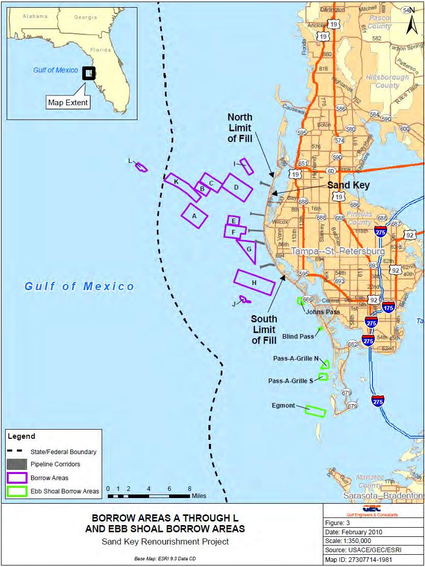
174

175
176 The purpose of this Biological Assessment (BA) is to address the effect of the Sand Key Beach Renourishment Project on ESA-listed species, listed as endangered or threatened under the Federal and state Endangered Species Act (ESA). 1.2 PROJECT BACKGROUND Previous nourishments on Sand Key include: North Redington Beach and Redington Shores in 1988, Indian Rocks Beach in 1990, Indian Shores in 1992, the initial nourishment of the Sand Key portion of Clearwater and Belleair Beach and the first nourishment of previous locations in1998; and the entire Sand Key project in 2005 and Fill was generally obtained from Egmont Channel Shoal. However, the round trip boat trip to the Northern portion of Sand Key is approximately 45 miles because the water is shallow and the ships have to follow the contours. Due to the high cost of the last renourishment ($45 million), the USACE wanted to obtain fill from a closer site. Coordination and consultation with the U.S. Fish and Wildlife Service (USFWS) and the National Marine Fisheries Service (NMFS) was previously conducted on the Pinellas County Beach Renourishment Project. A final Coordination Act Report was completed by the USFWS in June of 1996: Final Fish and Wildlife Coordination Act Report on the Pinellas County Beach Renourishment Project, June USFWS South Florida Ecosystem Office, Vero Beach, Florida. The following Biological Opinions were prepared for previous shore protection and dredging projects on the South-Central Gulf Coast of Florida and are relevant to the proposed activities. NMFS Biological Opinion dated October 1, 1996, Dredging of Egmont Shoal to Nourish Pinellas County, Florida, Beaches. NMFS, Southeast Regional Office. USFWS Biological Opinion dated November 30, 1991, Indian Shores Beach Renourishment NMFS, Southeast Regional Office. NMFS Biological Opinion dated October 26, 1999, Maintenance Dredging of Charlotte Harbor Entrance Channel. NMFS, Southeast Regional Office. NMFS (as amended in 2005 and 2007). Biological Opinion to the U.S. Army Corps of Engineers on Dredging of Gulf of Mexico Navigation Channels and Sand Mining ( Borrow ) Areas Using Hopper Dredges by USACE Galveston, New Orleans, Mobile, and Jacksonville Districts (Consultation Number F/SER/2000/01287). NOAA National Marine Fisheries Service, Southeast Regional Office. November 19, This BA addresses the proposed action in compliance with Section 7(c) of the ESA of 1973, as amended. Section 7 of the ESA ensures that, through consultation (or conferencing for proposed species) with the USFWS, Federal actions do not jeopardize the continued existence of any
177 threatened, endangered, or proposed species, or result in the destruction or adverse modification of critical habitat. 1.3 SPECIES AND CRITICAL HABITAT TO BE ADDRESSED Listed Species The USACE has determined that the following listed species under the purview of the USFWS may be present in the area and may be affected by dredging the proposed borrow area and renourishing the beach at Sand Key: Table 1. Listed Species from Pinellas County That Could Be Affected By the Proposed Project Federal Status Species Scientific Name SEA TURTLES Loggerhead sea turtle Caretta caretta T LT Kemp's ridley sea turtle Lepidochelys kempii E LE Green sea turtle Chelonia mydas T LE Hawksbill sea turtle Eretmochelys imbricate T LE Leatherback sea turtle Dermochelys coriacea T LE MARINE MAMMALS Florida manatee Trichechus manatus latirostris E LE E, LE=Endangered; T, LT=Threatened; LS=Species of Special Concern Critical habitat No critical habitat for the above-mentioned species is located within the project area. 2.0 DESCRIPTION OF THE PROPOSED ACTION 2.1 Renourishment Area State Status The USACE proposes to renourish an 8.7-mile section of beach along the shoreline of the Gulf of Mexico in Pinellas County, Florida, on Sand Key from Clearwater Pass to John s Pass, including the Sand Key portion of Clearwater Beach, Belleair Beach, Indian Rocks Beach, Indian Shores, Redington Shores, and North Redington Beach (a one mile section at Belleair Shore between R-66 and R-72 will not be renourished). The beach would be renourished between Florida Department of Environmental Protection (FDEP) reference monuments R-56 and R-66 and R-72 and R-108. The proposed project would place approximately 1.8 million cubic yards of beach-compatible sand from an offshore borrow area (Figure 1). The fill material will be similar in both coloration and grain size distribution to the native beach. The fill material will be free of construction debris, rocks, or other foreign matter and will not contain, on average, greater than 10 percent fines (i.e., silt and clay passing the #200 sieve) and will not contain, on average, greater than 5
178 percent coarse gravel or cobbles, inclusive of shell material (retained by the #4 sieve). The sand will be mechanically dredged by a clamshell dredge, loaded in a scow, or sand barge, that will be pushed to the beach project area with tugboats. Once offshore of the beach, the scows will be hooked up to an unloader that will pump the sand through a submerged pipeline to the beach. 2.2 Offshore Sand Source Borrow Area L is located approximately 12.8 miles west of Clearwater Pass in Federal Waters (Figure 1). Borrow Area L was selected based upon these criteria: beach sand compatibility, adequate available volume, reduced amount of hardbottom habitats, absence of cultural resources, and proximity to the renourishment areas. A sand resource survey was conducted in 1994 by the USACE to identify borrow areas closer to the renourishment site. Nine study areas (designated A through I) were identified that contained material that may be compatible to the beach sand. Only three of these areas (C, D, and H) were found to contain sufficient quantities of suitable material and additional geophysical and vibracore data were collected to determine suitability. Areas D and H were found to have potentially compatible sand; however, the quantity (889,400 cubic yards) was insufficient for the Sand Key renourishment project. Three additional areas (J through L) were examined and Area L was found to contain a sufficient quantity of suitable material. 3.0 DESCRIPTION OF THE PROJECT AREA The action area includes the beach from mean low low water (MLLW) to the crest of the primary dune or landward structure and is located between FDEP monuments R56 and R108, except for a gap between R-66 and R-72. The action area also includes nearshore waters off Sand Key and Borrow Area L in Federal waters. The action area contains suitable nesting habitat for sea turtles and activity in this area could impact nesting females, their nests and eggs, and any hatchlings, either in the nest or emerging from the nest and moving to the Gulf of Mexico. The nearshore and offshore portion of the action area also contains hardbottom areas. 3.1 HABITATS Offshore Sand Bottom Communities Softbottom habitats include areas with little or no rock, limestone, or hard coral structure, and comprise mostly sand, shelly sand, mud, and silt substrates. Where sand is the primary substrate and vegetation is lacking, the most diverse portion of the biota is the benthic infauna. The most consistent animals within these communities are polychaetes, oligochaetes, mollusks, sipunculans, peracarid crustaceans, flatworms, and nemerteans. Other frequent occupants of these habitats include demersal fishes (e.g., flounders), bivalves, decapod crustaceans, and certain shrimps Hardbottom Communities Lyons and Collard (1974) described these communities as areas of moderate wave energy with quartz sand and shell fragment sediments extending offshore. Large temperate mollusks and
179 echinoderms tend be the dominant animals. In areas over 10 meters deep, exposed rock substrate allows for the establishment of scleractinians, mollusks, crustaceans, tunicates, and other species commonly found in south Florida waters (Smith, 1974; Lyons and Collard, 1974). Quartz sands with biologically influenced carbonates present also dominate the sediments within this area Marine Algae The marine algae present within the areas offshore of Pinellas County are highly diverse. Phillips, et al. (1960) identified 95 taxa of algae within areas of similar depth in this area. Dominant algal species observed during this and other studies include Caulerpa sp., Halimeda sp., Udotea flabellum, Sargassum sp., and Rhipocephalus phoenix (Phillips, et al., 1960; EPA, 1981; CZR, 1991) Invertebrates Many of the benthic invertebrates associated with hardbottom habitats along the eastern Gulf of Mexico are similar to species found in the more tropical waters of the Caribbean and south Florida reef tract. Lyons and Collard (1974) characterized the shallow shelf habitat offshore of Pinellas County as an area with sediments dominated by quartz sand and biogenically derived carbonates with exposed rock substrate. The exposed rock provides habitat for attached organisms, such as corals, and associated free-living invertebrates. Previous studies have identified species common to habitats offshore of Pinellas County (EPA, 1981; CZR, 1991; Child, 1992; Posey, et. al, 1996). The species listed in these previous studies compares closely to species observed during recent surveys (Dial Cordy and Associates, 2001, 2002a, 2002b) (Table 3). Over 40 invertebrate species were observed from the diver and video surveys. There are many more cryptic and less obvious species present within these complex habitats On-site Assessments On-site assessments of marine resources within the project area for a previous renourishment project were conducted in 2001 and Dominant aquatic community types were documented within and adjacent to nine borrow areas, pipeline corridors and nearshore areas. Surveys of ebb tidal shoal areas and the Pass-a-Grille channel were also performed. Marine habitats identified during the survey included hardbottom, shell hash, and open sand habitat. A list of coral and other species observed in hardbottom habitats within the study area during recent surveys is included in Table 2. Table 2 Benthic Taxa Observed During USACE Borrow Area Surveys Common Name Scientific Name Sponges brown bowl sponge Cribrochalina vasculum giant barrel sponge Xestospongia muta loggerhead sponge Spheciospongia vesparium
180 ball sponge dark volcano sponge brown variable sponge erect rope sponge Scleractin Corals tube coral blushing star coral cactus coral starlet coral knobby star coral mushroom coral hidden cup coral rose coral boulder star coral robust ivory tree coral branching fire coral Octocorals shelf-knob sea rod warty sea rod giant slit-pore sea rod delicate spiny sea rod orange spiny sea rod sea plume yellow sea whip colorful sea whip branching tube sponge Echinoderms common comet star beaded sea star rock-boring urchin striped sea star sea star banded sea star orange-ridged sea star variegated urchin Mollusks penshell lightning whelk tritons trumpet Florida horse conch Ircinia sp. Calyx podatypa Anthosigmella varians Amphimedon compressa Cladocora arbuscula Stephanocoenia mitchelinii Isophyllia sinuosa Siderastrea sp. Solenastrea hyades Scolymia lacera Phyllangia americana Manicina aereolata Montastrea annularis Oculina robusta Millepora alcicornis Eunicea succinea Eunicea calyculata Plexaurella nutans Muricea laxa Muricea elongata Pseudoterogorgia sp. Pterogorgia citrina Leptogorgia virgulata Pseudoceratina crassa Linckia guildingii Astropecten articulatus Echinaster spinulosus Luidia clathara Luidia sp. Luidia alternata Echinometra lucunter Lytechinus variegates Pinna carnea Busycon contrarium Charonia variegata Pleuroploca gigantean
181 Crustaceans Florida stone crab Tunicates colonial tunicate overgrowing tunicates condominium tunicate Source: USACE 2002 Menippe mercenaria Clavelina sp. Family Didemnidae Eudistoma sp. In addition, the USFWS conducted dive surveys on the nearshore hardbottom in the project area (Table 3). Table 3 Species Observed During USFWS Nearshore Livebottom Surveys Species Scientific name Fishes Sand seatrout Cynoscion arenarius Spotted seatrout C. nebulosus Sea robin Triglidae White grunt Haemulon plumieri Slippery dick Halichoeres bivittatus Porcupine fish Diodon hystrix Hairy blenny Labrisomus nuchipinnis Invertebrates Sea whips Leptogorgia sp. Sea anemones Zoanthidae Bryozoans Class Ectoprocta Sea fan Lophogorgia sp. Yellow chimney sponge Cliona celata Tunicates Disemnum candidum botryllus sp. Sea urchin Lytechinus variegatus Stone crab Menippe mercenaria Tube worms Class Polychaeta Source: USFWS Pelagic Communities The pelagic community consists of all species that can occur in the water column. Species can include phytoplankton, zooplankton, floating algae; eggs, larval, and juvenile invertebrates and eggs, larval, juvenile, and adult fishes. Sea turtles and marine mammals are also pelagic species. 4.0 THREATENED AND ENDANGERED SPECIES This section includes life history, including nesting and feeding behaviors, and critical habitat for the species that could be found in the action area (from Table 1).
182 4.1 SEA TURTLES Sea turtle numbers have declined due to habitat loss; killing for meat and egg harvesting; pollution and debris ingestion; gill-net, long-line, and trawling fisheries; beach armoring and nourishment; beach erosion; artificial lighting; and coastal development. Loggerhead turtle Loggerhead turtles occur throughout the temperate and tropical regions of the Atlantic, Pacific, and Indian Oceans and are widely distributed within their range. They can be found hundreds of miles offshore or inshore in bays, lagoons, salt marshes, creeks, ship channels, and the mouths of large rivers (USFWS, 2010). Loggerheads primarily feed on mollusks, crustaceans, fish, and other marine animals. Feeding areas often include coral reefs, rocky areas, and ship wrecks. Adult loggerheads may make considerable migrations between foraging areas and nesting beaches. Loggerheads reach sexual maturity at about 35 years of age. Loggerheads nest from Texas to Virginia within the continental U.S. and a large number of loggerheads nest in the southeastern U.S. The total number of nests per year over the last decade in the U.S. is estimated to be between 47,000 and 90,000 (NMFS and USFWS, 2008). Loggerheads nest between late April and early September. Females exhibit strong nest site fidelity and return to their natal beach to nest. Loggerheads typically nest above the high-tide mark on open beaches or along narrow bays with suitable sand. They may prefer steeply sloped beaches with gradually sloped offshore approaches. Three to five nests, or more may be laid during a single nesting season; eggs incubate after about two months. Hatchlings are pelagic move to downwelling areas where seagrass and debris accumulates and frequently associate with Sargassum rafts where as juveniles they remain for years. Larger, juvenile loggerheads become benthic feeders in coastal areas. During nesting season, adults remain in nearshore and estuarine waters near nesting beaches. No critical habitat has been designated for the loggerhead. Green sea turtle Green turtles are found in tropical and sub-tropical waters around the world. In the U.S. Atlantic waters, green turtles are found from Texas to Massachusetts, the U.S. Virgin Islands, and Puerto Rico. Green turtles are generally found over shallow flats and seagrass and algae areas inside bays and inlets. Resting areas include rocky bottoms, oyster, worm, and coral reefs. Post-hatchling pelagic-stage turtles may be omnivorous. Adult turtles are herbivores and consume algae and seagrasses. In Florida, most green turtle nesting occurs on the east coast south of Cape Canaveral (NMFS and UFWS, 1991). However, 29 nests were documented on the southwest coast of Florida in 1994, in five southwest counties, including Pinellas (Meylan, et al., 1995). Green turtles frequently nest on open high-energy beaches with a sloping platform and minimal disturbance; nests are dug above the high-water line. Nesting occurs in Florida from June to late September.
183 After leaving the nest, hatchlings swim to convergence zones and may seek refuge and food in Sargassum rafts; where they remain for a period of time. Older turtles leave the pelagic habitat to feed benthically. Critical habitat consists of waters surrounding Culebra Island, Puerto Rico. Kemp s ridley turtle Kemp s ridley turtles are found in shallow nearshore and inshore waters of the northern Gulf of Mexico, particularly in Louisiana. During the winter, northern Gulf turtles may travel to deeper water. Turtles found in the northwestern Atlantic Ocean feed in coastal waters up to New England during the summer and migrate southward during the winter (NMFS and UFWS, 1992). Kemp s ridleys are often found in salt marsh waterbodies. Neonatal Kemp s ridleys feed on Sargassum and infauna or other epipelagic species. Post-pelagic turtles are benthic feeders over sand and mud bottoms and primarily consume crabs, particularly portunid crabs, and other crustaceans. Hatchlings may become entrained in Gulf of Mexico eddies, are dispersed by oceanic surface currents, then enter coastal shallow water habitats when they reach about 20 cm in length. Kemp s ridleys prefer to nest on beaches backed by extensive swamps or large open waterbodies with seasonal narrow connections to the ocean. Nesting occurs from April to July, principally on the beaches of the western Gulf of Mexico. During the nesting season, females may either stay in nearshore waters or may move up to 10 km along the beach before returning to the nesting beach. No critical habitat has been designated. Hawksbill turtle Hawksbill turtles occur in tropical and subtropical seas of the Atlantic, Pacific, and Indian oceans. In the continental U.S., hawksbills have been found along the Gulf of Mexico and along the eastern seaboard as far north as Massachusetts; however, but are rare north of Florida. Hawksbill turtles are frequently found along rocky areas, coral reefs, shallow coastal areas, lagoons or oceanic islands, and narrow creeks and passes. Post-hatchlings are pelagic and occupy convergence zones, floating among Sargassum and debris and may eat fish eggs, Sargassum, and debris (NOAA and USFWS, 1993). Hawksbill sea turtles feed primarily on sponges once they transition to a benthic existence; only specific sponge species are consumed. Within the continental U.S., hawksbills nest only along the southeastern coast of Florida and the Florida Keys. Hawksbills nest on low- and high-energy beaches. Hawksbills nest on many types of substrates and may place nests under vegetation. Nesting is generally at low densities, ranging from a few dozen to a few hundred individuals, on scattered undisturbed deep-sand small beaches, except for long expanses of beach on the Gulf and Caribbean coasts of the Yucatán Peninsula, Mexico. In most locations, hawksbills nest between April and November; a few hawksbills nest in the Florida Keys and on the east coast of Florida. Hawksbills frequently return to the same beach to nest.
184 Critical habitat has been designated at Isla Mona, Culebra Island, Cayo Norte, and Island Culebrita, Puerto Rico. Leatherback turtle Leatherback turtles are highly migratory and pelagic. Leatherbacks can be found in deeper water than most other species of sea turtles and have been found in cold waters, such as Alaska, due to the ability to regulate their core body temperature somewhat. Leatherbacks primarily feed on jellyfish, but also consume sea urchins, squid, crustaceans, tunicates, fish, blue-green algae, and floating seaweed. In the Gulf of Mexico, leatherbacks are frequently associated with cabbage head jellyfish Stomolophus and Aurelia jellyfish. The distribution and food habits of posthatchling and juvenile leatherbacks are unknown, although they may be pelagic and associate with Sargassum weed. Nesting occurs in the U.S. from March to July; the Pacific coast of Mexico has the largest known concentration of nesting leatherbacks. From 38 to 125 leatherbacks nested in Florida from 1981 to Nesting does not appear to occur on the west coast of Florida, although one nest was observed off the northwest coast of Florida in Females prefer to nest on well-sloped highenergy sand beaches backed with vegetation near deep water and generally rough seas. Nesting surveys may underestimate leatherhead nesting because they generally begin in May and leatherbacks can nest as early as late February. Although many females return to the same beaches to nest, some females have been found to nest on beaches up to 100 km apart in a single season. Critical habitat is in the U.S. Virgin Islands. Site-specific Information on Sea Turtles Nesting sea turtles in the Pinellas County area are primarily loggerheads, although a few green turtles nests have been found on an infrequent basis. All the sea turtle nests reported from Pinellas County from 2004 to 2008 were those of loggerhead sea turtles (Table 4 - Fish and Wildlife Research Institute of the Florida Fish and Wildlife Conservation Commission, 2010). Similarly, sea turtles nesting in the Tampa Bay area from were loggerhead turtles with two exceptions, a single Kemp s ridley on Madeira Beach in Pinellas County in May 1989 and a single green sea turtle at Fort de Soto in Pinellas County in 1994 (Meylan et al., 1994). Only 11 hawksbill sea turtle nests were reported in Florida from 1979 to 1992 and the Kemp s ridley nest in Pinellas County mentioned previously was the only nest of that species reported from Florida during that time period (Meylan et al., 1995). Strandings in Tampa Bay inshore waters from 1980 through 1997 were examined by Meylan et al. (1998). Most of the stranded turtles were loggerheads, followed by Kemp s ridleys, green turtles, and hawksbills. Strandings of loggerheads were more numerous from March through June, with a smaller peak in October and November. Green turtles were primarily stranded outside the summer months and peaked in February and March. Kemp s ridleys were stranded in all months except August, with no apparent seasonal pattern.
185 Table 4: Sea Turtle Nests reported on Pinellas County Beaches from Loggerhead Green Leatherback Source: Fish and Wildlife Research Institute, FLORIDA MANATEE The Florida manatee (Trichechus manatus latirostris) is a subspecies of the West Indian manatee (Trichechus manatus) and can be found throughout the southeastern United States, including the project area. Manatees may travel great distances during warm months and have been spotted in Massachusetts and Texas (USFWS, 2007). Manatees are a sub-tropical species and are cold intolerant, in Florida, they prefer warm-water sites during the winter, leaving only to feed during warming trends. Manatees congregate near warm water sites, such as natural springs, power plants, and deep canals, when temperatures drop. Florida manatees are found in freshwater, brackish, and marine environments, including coastal tidal rivers and streams, mangrove swamps, salt marshes, freshwater springs, and vegetated bottoms. Manatees are herbivores and feed on aquatic vegetation. Preferred feeding areas in coastal and riverine habitats appear to be shallow grass beds near deep channels. Primary threats include watercraft-related strikes, entanglement in fishing lines and crab pot lines, exposure to cold and red tide (USFWS 2007). Site-Specific Information on Marine Mammals Several Federal and state manatee protection areas are located in Tampa Bay, including around several power plants. Manatees inhabit both fresh and salt water and have been observed in canals, rivers, estuaries, bays, and on rare occasion have been observed as far as 6 km off the Florida Gulf coast (USFWS, 1996). Aerial surveys indicate that as many as 190 manatees may use Tampa Bay (Ackerman, 1995). Surveys show that over 900 manatees inhabit the west coast of Florida. The highest concentrations of manatees along Florida's Gulf coast exist in Citrus, Levy, Lee, and Collier Counties. Data suggest that of the manatees living in the Tampa Bay area, most occur within the bay where water temperatures are more stable year round. Only 15 manatees were surveyed in the eastern portion of Tampa Bay during aerial surveys in 1992 (Ackerman, 1995). The project area is in nearshore and offshore areas and any manatees present in the area would likely be migrating between feeding areas. 5.0 DISCUSSION OF POTENTIAL IMPACTS TO LISTED SPECIES
186 Project-Specific Information on Sea Turtles All five species are listed as either threatened or endangered under the ESA. Several biological opinions provided by the USFWS for previous beach placement actions on the Gulf coast of Florida discuss in detail the background information for sea turtles including, status and distribution, behavior, life history, population dynamics, etc. and are included by reference below: US Fish and Wildlife Service. Biological Opinion, September 7, Mexico Beach Canal Sand Bypass, Gulf of Mexico, Bay County, Florida. Public Notice (IP- DHB). US Fish and Wildlife Service. Biological Opinion, February 20, Beach placement of dredge material from the Panama City Harbor Channel Maintenance Dredging. US Fish and Wildlife Service. Biological Opinion, April 30, Walton County City of Destin Beach Restoration Gulf of Mexico, Walton and Okaloosa Counties, Florida. Public Notice SAJ IP-TLZ. Critical habitat has not been designated in the continental U.S.; therefore, the proposed project would not adversely modify critical habitat. Potential impacts to the nesting activities of sea turtles due to beach renourishment may include changes in beach slope, formation of escarpments, sediment compaction, changes in the incubation environment, and changes in beach lighting. To the maximum extent practicable, construction activities on the beach will be scheduled to avoid the sea turtle nesting season (May 1 through September 30). If the nesting season cannot be avoided, project modifications (i.e. modified pipeline routes, staging areas, etc.) may be made during the nesting season to help avoid or minimize potential impacts. If nourishment beach activities extend into portions of the nesting season, monitoring for sea turtle nesting activity will be considered throughout the construction area including the disposal area and beachfront pipeline routes in accordance with guidelines provided by the USFWS. The location and operation of heavy equipment within the project area will be limited to daylight hours to the maximum extent practicable to minimize impacts to nesting sea turtles. Monitoring for nest activity prior to the construction activities may be necessary to allow nests laid within a potential construction zone to be relocated outside of the construction zone prior to project commencement to avoid potential losses. However, relocation measures should be considered as a last alternative. The proposed project could potentially adversely affect sea turtles in the following ways (USACE, 2007): Both stockpiled pipe on the beach and the pipeline route running parallel to the shoreline may impede nesting sea turtles from accessing more suitable nesting sites,
187 The operation of heavy equipment on the beach may impact nesting females and incubating nests, Associated lighting impacts from the nighttime operations and the increased beach profile elevation may deter nesting females from coming ashore and disorient emerging hatchlings, Burial of existing nests may occur if missed by monitoring efforts, Escarpment formations may impede nesting females as well as cause potential losses of sand during the beach equilibration process, Nesting success may be reduced as a result of relocation efforts, Sediment density (compaction), shear resistance (hardness), sediment moisture content, beach slope, sediment color, sediment grain size, sediment grain shape, and sediment grain mineral content may be altered, potentially effecting the nesting and incubating environment, Hard sediment may prevent a female from digging a nest or result in a poorly constructed nest cavity, Changes in sediment properties and color could alter the temperature of the beach and incubating nests; thus influencing sex ratios, and Hard structures (groins, breakwaters, etc.) may prevent access to suitable nesting sites, directly and indirectly interfere with the nesting process, impede and/or trap nesting females and hatchlings resulting in increased energy expenditure, concentrate predators, and alter longshore sediment transport and down-drift erosion. The USACE plans to alleviate impacts to nesting sea turtles in the project area by implementing steps that are now common practice including, but not limited to: design modifications, contingency plans, risk assessments, sediment quality monitoring, compaction tests, tilling, leveling escarpments in the fill, and monitoring for nests, etc. (USACE, 2007). Despite the implementation of the measures outlined above, the chance of adversely affecting nesting sea turtles still exists. Therefore, it has been determined that the proposed actions may adversely affect loggerhead and green turtles. Project-Specific Information on the Florida Manatee Direct effects on the Florida manatee from the dredging operation and the placement of material on the beach should be minor. Vessels, including crew boats, tugs, barges, etc., will be used in dredging operations; therefore, the potential for collision may exist. To ensure that dredging does not adversely affect manatees, the USACE has adopted the Special Manatee Protection Conditions as part of its standard operating procedures on all water-related projects. These
188 conditions are available on the USACE, Jacksonville District website at Since the Special Manatee Protection Conditions will be incorporated into the USACE specifications and will be adhered to by the project Contractor, the proposed actions may affect but are not likely to adversely affect the Florida manatee. There is no designated critical habitat present in the project area. 6.0 EFFECTS ASSESSMENT Based on the information provided in this assessment, the USACE determines that the proposed project will have the following affect on the listed species: Table 5. Summary of Potential Effects on Listed Species That May be Found in the Project Area Federal Species Scientific Name Status SEA TURTLES Loggerhead sea turtle Caretta caretta T May adversely affect Kemp's ridley sea Lepidochelys kempii E May adversely affect turtle Green sea turtle Chelonia mydas T May adversely affect Hawksbill sea turtle Eretmochelys imbricate T May affect, but is not likely to adversely affect Leatherback sea turtle Dermochelys coriacea T May affect, but is not likely to adversely affect FLORIDA MANATEE Florida manatee Trichechus manatus latirostris E May affect, but is not likely to adversely affect E=Endangered; T=Threatened 7.0 REFERENCES Florida Department of Environmental Protection. Critically Eroded Beaches in Florida Bureau of Beaches and Coastal Systems Division Of Water Resource Management, Department Of Environmental Protection, State of Florida. Meylan, A., B. Schroeder, and A. Mosier Sea turtle nesting activity in the State of Florida Florida Mar. Research Publ. 52: I-51. National Marine Fisheries Service and U.S. Fish and Wildlife Service Recovery Plan for U.S. Population of Atlantic Green Turtle (Chelonia mydas). National Marine Fisheries Service, Washington, D.C.
189 National Marine Fisheries Service and U.S. Fish and Wildlife Service Recovery Plan for U.S. Population for the Kemp s Ridley Sea Turtle (Lepidochelys kempii). National Marine Fisheries Service, St. Petersburg, FL. National Marine Fisheries Service and U.S. Fish and Wildlife Service Recovery Plan for Leatherback Turtles (Dermochelys coriacea) in the U.S. Caribbean, Atlantic and Gulf of Mexico. National Marine Fisheries Service, Washington, D.C. National Marine Fisheries Service and U.S. Fish and Wildlife Service Recovery Plan for Hawksbill Turtles in the U.S. Caribbean Sea, Atlantic Ocean, and Gulf of Mexico, (Eretmochelys imbricata), National Marine Fisheries Service, St. Petersburg, Florida. National Marine Fisheries Service and U.S. Fish and Wildlife Service Recovery Plan for the Northwest Atlantic Population of the Loggerhead Sea Turtle (Caretta caretta), Second Revision. National Marine Fisheries Service, Silver Spring, MD. USACE Environmental effects of dredging: Technical note. Alternative Dredging Equipment and Operational Methods to Minimize Sea Turtle Mortalities. Technical note EEDP U.S. Army Waterways Experiment Station, 3909 Halls Ferry Road, Vicksburg, MS USACE Summary of First Regional Workshop on Dredging, Beach Nourishment, and Birds on the South Atlantic Coast. ERDC/EL TR USACE Engineer Research and Development Center. USACE Draft Regional Biological Assessment Sand Placement along the Coast of Florida. U.S. Army Corps of Engineers, Jacksonville District. U.S. Fish and Wildlife Service and Gulf States Marine Fisheries Commission Gulf Sturgeon Recovery Plan. Atlanta, Georgia. 170 pp. U.S. Fish and Wildlife Service West Indian Manatee (Trichechus manatus) 5-Year Review: Summary and Evaluation. U.S. Fish and Wildlife Service, Ecological Services Office, Jacksonville, Florida, Caribbean Field Office, Boquerón, Puerto Rico. 79 pp.
190
191
192

193 Dan Hughes USACE Jacksonville District P.O. Box 4970 Jacksonville, FL THPO#: August 5, 2010 Subject: Assessment of Effects for the Proposed Sand Key Beach Re-nourishment Project, Offshore Sand Key, Pinellas County, Florida Dear Mr. Hughes, The Seminole Tribe of Florida s Tribal Historic Preservation Office (STOF-THPO) has received the Corps of Engineers correspondence concerning the aforementioned project. The STOF-THPO has no objection to your findings at this time. However, the STOF-THPO would like to be informed if cultural resources that are potentially ancestral or historically relevant to the Seminole Tribe of Florida are inadvertently discovered during the construction process. We thank you for the opportunity to review the information that has been sent to date regarding this project. Please reference THPO for any related issues. We look forward to working with you in the future. Sincerely, Direct routine inquiries to: Willard Steele Tribal Historic Preservation Officer Seminole Tribe of Florida Anne Mullins Compliance Review Supervisor annemullins@semtribe.com ety:am
194
195
196
197
198
199
200
201
202 Hershorin, Aubree SAJ From: Sent: To: Subject: Mark Sramek Friday, November 12, :32 PM Hershorin, Aubree SAJ Re: FW: RAI # 3 DEP Permit # JC Sand Key Beach Nourishment NOAA's National Marine Fisheries Service, Southeast Region, Habitat Conservation Division, has reviewed the subject Department of the Army permit application listed below. We anticipate that any adverse effects that might occur on marine and anadromous fishery resources would be minimal and, therefore, do not object to issuance of the permit. Hershorin, Aubree SAJ wrote: <<image001.gif>> Hi Mark, I noticed that #28 addresses EFH under your purview (likely why you were copied on the RAI response). In case you have not yet received the Notice of Availability of the Draft EA, I've attached it for your reference. The Draft EA is available at our website at BeachErosion/Sand_Key_Draft_EA.pdf for your review and comment. We are providing 400 foot buffer around all significant hardbottom communities at the borrow area site that were identified by sidescan sonar data. If you have any questions or need additional information, please don't hesitate to contact me. Thank you, Aubree Hershorin Biologist, U.S. Army Corps of Engineers Planning Division 701 San Marco Blvd. Jacksonville, FL Phone: (904) Original Message From: Deal, Tori [mailto:tori.deal@dep.state.fl.us] Sent: Friday, July 30, :42 PM To: Summa, Eric P SAJ Cc: Edwards, Lainie; Seeling, Martin; Barnett, Michael; Nicole Elko; McAdams, James J SAJ; Jacqueline.J.Keiser@saj02.usace.army.mil; Lagrone, James W SAJ; Vorstadt, Bill; Mark Sramek; Hershorin, Aubree SAJ; Brantly, Robert; Malakar, Subarna; Koch, Jennifer L.; Florko, Catherine; Woodruff, Paden; Dow, Roxane; Reed, Alex (Jillian); Kosmynin, Vladimir; JCP Compliance; ASquires@pinellascounty.org; Runnels, Randy Subject: RAI # 3 DEP Permit # JC Sand Key Beach Nourishment Hello All, Please see the link below for RAI # 3 DEP Permit # JC Sand Key Beach Nourishment: 1
203 prmt/pinellas/pending/ _sand_key_beach_nourishment/001 JC/Completeness%20Review/RAI_%233/ Thank you, Tori Deal Bureau of Beaches and Coastal Systems Joint Coastal Permitting Assistant Telephone: contact The Department of Environmental Protection values your feedback as a customer. DEP Secretary Michael W. Sole is committed to continuously assessing and improving the level and quality of services provided to you. Please take a few minutes to comment on the quality of service you received. Simply click on this link to the DEP Customer Survey < Thank you in advance for completing the survey. 2
204 p United States Department of the Interior u. S. FISH AND WILDLIFE SERVICE 7915 BAYMEADOWS WAY, SUITE 200 JACKSONVILLE, FLORIDA IN REPLY REFER TO: FWS Log No F-0301 December 3, 2010 Colonel Alfred A. Pantano, Jr. District Engineer Department ofthe Army Jacksonville District Corps of Engineers P.O. Box 4970 Jacksonville, FL Dear Colonel Pantano: This document is the U.S. Fish and Wildlife Service's (Service) biological opinion based on our review ofthe proposed sand placement on Sand Key located in Pinellas County, Florida, and its effects on the loggerhead sea turtle (Caretta caretta), green sea turtle (Chelonia mydas), Kemp's ridley sea turtle (Lepidochelys kempii), West Indian (Florida) manatee (Trichechus manatus latirostris), and piping plover (Charadrius melodus) in accordance with section 7 ofthe Endangered Species Act (Act) of 1973, as amended (16 U.S.C et seq.). Your request for formal consultation was received on 19July This biological opinion is based on information provided in the 10 March 2010 and 14 July 2010 correspondences from your office. A complete administrative record of this consultation is on file at the Service's St. Petersburg Ecological Services Satellite Office. The Corps determined that the proposed action may affect, but was not likely to adversely affect the Florida manatee and the piping plover. The Corps also determined that the proposed action may adversely affect the loggerhead, green, and Kemp's ridley sea turtles. The Service concurs with these determinations. Florida manatee The Service concurs with this determination providing the Standard Manatee Conditions for In-Water Work (2009)are implemented during the construction ofthis project. In. addition, we recommend the placement of mooring fenders on barges and other large vessels such that, when moored together or at the docking facilities, the fenders provide a minimum stand-off distance, at and below the water line, of 4 feet under maximum compression. Furthermore, no destruction or adverse modification of designated critical
205 habitat will result from this action. Because no incidental take ofmanatees is anticipated, no such authorization under the Marine Mammal Protection Act (MMP A) is required. Piping plover Non-breeding piping plovers are known to occur along Pinellas County's beaches. Natural organic material deposited on the beach (wrack) provides important foraging and roosting habitat for piping plovers and other shorebirds. It also serves to protect important shorebird habitat by helping stabilize beaches through reduction in erosive processes such as eolian sand transport. Protection ofwrack can help to offset the direct and indirect impacts associated with beach nourishment and ensuing human disturbance. The Service has detennined that the proposed project may affect, but is not likely to adversely affect the piping plover provided the inclusion ofthe following conditions: 1. Piping plover optimal habitat shall be avoided to the maximum extent practicable. Site selection for equipment staging, travel corridors, construction vehicles including all - terrain vehicles and pipeline alignment shall stay just above or just below the primary "wrack" line and swash zone. The water and land-based loading and unloading of equipment, materials, supplies, and personnel shall be limited to the footprint ofthe staging and storage area, with the exception ofthe transportation of job-related personnel. 2. The Service and the Florida Fish arid Wildlife Conservation Commission (FWC) will meet with the local sponsor to discuss areas within one mile ofthe north end of Johns Pass and the south end ofclearwater Pass at Sand Key Park where natural. accumulation ofwrack can remain on the beach year-round. This meeting shall occur prior to the proposed activity. 3. Vehicles including all-terrain Vehicles (ATVs) traversing the beach, used by.beach life-guards, beach maintenance employees, turtle watch volunteers and law enforcement will avoid the soft sand areas in the wrack protection zone and follow the FWC's Beach Driving Best Management Practices: ( BeachDriving.htm). Emergency vehicles shall have full access to the beach including the wrack protection zone. 4. Educational signs will be installed highlighting the importance ofbeach habitats to wildlife and explaining the importance ofthe wrack within one mile ofthe north end ofjohns Pass and the south end ofclearwater Pass at Sand Key Park the shoreline. The FWC will provide examples ofthe infonnation to include on these signs. Based on the preceding, the Service has detennined that the proposed project may affect, but is not likely to adversely affect the piping plover provided that the Corps project plans included the above measures to preserve piping plover foraging and roosting habitat within the project area. 2
206 Consultation History On 15 March 2010, the Service received correspondence from the Corps requesting to abide by the terms and conditions ofa biological opinion issued in 2005 for nourishment ofsand Key. The Service denied this request. On 14 July 2010, the Serviced received a Biological Assessment for the Pinellas County Beach Erosion Control Project. BIOLOGICAL OPINION DESCRIPTION OF PROPOSED ACTION The applicant proposes to place approximately 1.8 million cubic yards of sand along 8.7 miles ofshoreline ofthe Gulf ofmexico in Pinellas County, Florida, on Sand Key from Clearwater Pass to John's Pass including the Sand Key portion ofclearwater Beach, Belleair Beach, Indian Rocks Beach, Indian Shores, Redington Shores, and North Redington Beach. The sand placement is between the Florida Department ofenvironmental Protection's (FDEP) reference monuments R-56 to R-66 and R-72 to R-I08. A one mile section at Belleair Shore between R-66 and R-72 will not be part ofthis action. The proposed Borrow Area L is located in Federal Waters approximately 12.8 miles west of Clearwater Pass. The proposed project would place beach-compatible sand from the offshore borrow area with fill material similar in both coloration and grain size distribution to the existing beach. The fill material will be free of construction debris, rocks, or other foreign matter and will not contain, on average, greater than 10 percent fines (i.e. silt and clay passing the #200 sieve) and will not contain, on average, greater than 5 percent coarse gravel or cobbles, inclusive ofshell material (retained by the #4 sieve). The sand will be mechanically extracted by a clamshell dredge, loaded in a scow, or sand barge and transported by tugboats towards the project area beach. The sand will then be pumped through a submerged pipeline to.the beach. Action area The action area is defined as all areas to be affected directly or indirectly by the Federal action and not merely the immediate area involved in the action. The Service has determined that the action area for this project is between FDEP Reference Monuments R 56 to R-66 and R-72 to R-108. Conservation Measures Sea Turtles 1. FWC and the local sponsor have an agreement to conduct sea turtle monitoring for a minimum oftwo additional nesting seasons after nourishment event ifplaced sand remams. 3
207 STATUS OF THE SPECIES/CRITICAL HABITAT The Service has responsibility for implementing recovery ofsea turtles when they come ashore to nest. This biological opinion addresses nesting sea turtles, their nests and eggs, and hatchlings as they emerge from the nest and crawl to the sea. The National Oceanic and Atmospheric Administration's National Marine Fisheries Service (NMFS) has jurisdiction over sea turtles in the marine environment. Loggerhead Sea Turtle The loggerhead sea turtle was federally listed as a threatened species on July 28, 1978 (43 FR 32800). The loggerhead occurs throughout the temperate and tropical regions ofthe Atlantic, Pacific, and Indian Oceans. The loggerhead sea turtle grows to an average weight ofabout 200 pounds and is characterized by a large head with blunt jaws. Adults and sub adults have a reddish-brown carapace. Scales on the top ofthe head and top ofthe flippers are also reddish-brown with yellow on the borders. Hatchlings are a dull brown color (NMFS 2002a). The loggerhead feeds on mollusks, crustaceans, fish, and other marine animals. The loggerhead occurs throughout the temperate and tropical regions ofthe Atlantic, Pacific, and Indian Oceans. It may be found hundreds ofmiles out to sea, as well as in inshore areas such as bays, lagoons, salt marshes, creeks, ship channels, and the mouths of large rivers. Coral reefs, rocky places, and ship wrecks are often used as feeding areas. Within the Northwest Atlantic, the majority ofnesting activity occurs from April through September, with a peak in June and July (Williams-Walls et al. 1983, Dodd 1988, Weishampel et al. 2006). Nesting occurs within the Northwest Atlantic along the coasts of North America, Central America, northern South America, the Antilles, Bahamas, and Bermuda,but is concentrated in the southeastern U.S. and on the Yucatan Peninsula in Mexico on open beaches or along narrow bays having suitable sand (Sternberg 1981, Ehrhart 1989, Ehrhart et al. 2003, NMFS and Service 2008). No critical habitat has been designated for the loggerhead sea turtle. Green Sea Turtle The green sea turtle was federally listed as on July 28, 1978 (43 FR 32800). Breeding populations ofthe green turtle in Florida and along the Pacific Coast ofmexico are listed as endangered; all other populations are listed as threatened. The green sea turtle has a worldwide distribution in tropical and subtropical waters. The green sea turtle grows to a maximum size ofabout 4 f~et and a weight of440 pounds. It has a heart-shaped shell, small head, and single-clawed flippers.. The carapace is smooth and colored gray, green, brown and black. Hatchlings are black on top and white on the 4

208 bottom (NMFS 2002b). Hatchling green turtles eat a variety ofplants and animals,but adults feed almost exclusively on seagrasses and marine algae. Major green turtle nesting colonies in the Atlantic occur on Ascension Island, Aves Island, Costa Rica, and Surinam. Within the U.S., green turtles nest in small numbers in the U.S. Virgin Islands and Puerto Rico, and in larger numbers along the east coast offlorida, particularly in Brevard, Indian River, St. Lucie, Martin, Palm Beach, and Broward Counties (NMFS and Service 1991a). Nesting also has been documented along the Gulf coast of Florida from Escambia County through Franklin County in northwest Florida and from Pinellas County through Collier County in southwest Florida (FWC Statewide Nesting Beach Survey database). Green turtles have been known to nest in Georgia, but only on rare occasions (Georgia Department ofnatural Resources statewide nesting database). The green turtle also nests sporadically in North Carolina and South Carolina (North Carolina Wildlife Resources Commission statewide nesting database; South Carolina Department of Natural Resources statewide nesting database). Unconfirmed nesting ofgreen turtles in Alabama has also been reported (Bon Secour National Wildlife Refuge nesting reports). Green sea turtles are generally found in fairly shallow waters (except when migrating) inside reefs, bays, and inlets. The green turtle is attracted to lagoons and shoals with an abundance ofmarine grass and algae. Open beaches with a sloping platform and minimal disturbance are required for nesting. Critical habitat for the green sea turtle has been designated for the waters surrounding Culebra Island, Puerto Rico, and its outlying keys. Kemp's Ridley Sea Turtle The Kemp's ridley sea turtle was federally listed as endangered on December 2, 1970 (35 FR 18320). The Kemp's ridley, along with the flatback sea turtle (Natator depressus), has the most geographically restricted distribution ofany sea turtle species. The range of the Kemp's ridley includes the Gulf coasts of Mexico and the U.S., and the Atlantic coast of North America as far north as Nova Scotia and Newfoundland. Adult Kemp's ridleys, considered the smallest marine turtle in the world, weigh an average of 100 pounds with a carapace measuring between inches in length. The'almost circular carapace has a grayish green color while the plastron is pale yellowish to cream in color. The carapace is often as wide as it is long. Their diet consists mainly ofswimming crabs, but may also include fish, jellyfish, and an array ofmollusks. The majority ofnesting for the entire species occurs on the primary nesting beach at Rancho Nuevo, Mexico (Marquez-Millan. 1994). Outside of nesting, adult Kemp's ridleys are believed to spend most oftheir time in the Gulf ofmexico, while juveniles and sub adults also regularly occur along the eastern seaboard of the U.S. (Service and NMFS 1992). There have been rare instances when immature ridleys have been documented making transatlantic movements (Service and NMFS 1992). It was originally speculated that Kemp's ridleys that make it out of the Gulf ofmexico might be lost to the breeding population (Hendrickson 1980), but data indicate that many ofthese turtles are capable of 5
209 moving back into the Gulf ofmexico (Henwood and Ogren 1987). In fact, there are documented cases ofkemp's ridleys captured in the Atlantic that migrated back to the nesting beach at Rancho Nuevo (Schmid and Witzell 1997, Schmid 1998, Witzell 1998). Hatchlings, after leaving the nesting beach, are believed to become entrained in eddies within the Gulf ofmexico, where they are dispersed within the Gulf and Atlantic by oceanic surface currents until they reach about 7.9 inches in length, at which size they enter coastal shallow water habitats (Ogren 1989). No critical habitat has been designated for the Kemp's ridley sea turtle. Life history Loggerhead Sea Turtle Loggerheads are long-lived, slow-growing animals that use multiple habitats across entire ocean basins throughout their life history. This complex life history encompasses terrestrial, nearshore, and open ocean habitats. The three basic ecosystems in which loggerheads live are the: 1. Terrestrial zone (supralittoral) - the nesting beach where both oviposition (egg laying) and embryonic development and hatching occur. 2. Neritic zone - the inshore marine environment (from the surface to the sea floor) where water depths do not exceed 656 feet. The neritic zone generally includes the continental shelf, but in areas where the continental shelf is very narrow or nonexistent, the neritic zone conventionally extends to areas where water depths are less than 656 feet. 3. Oceanic zone - the vast open ocean environment (from the surface to the sea floor) where water depths are greater than 656 feet. Maximum intrinsic growth rates ofsea turtles are limited by the extremely long duration of the juvenile stage and fecundity. Loggerheads require high survival rates in the juvenile and adult stages, common constraints critical to maintaining long-lived, slow-growing species, to achieve positive or stable long-term population growth (Congdon et al. 1993; Heppell 1998; Crouse 1999; Heppell et al. 1999,2003; Musick 1999). 6

210 The generalized life historyofatlantic loggerheads is shown in Figure 1 (from Bolten 2003). TERRESTRIAL ZONE Ne o Seacr, f~pt jil\tf.j1l NERITIC ZONE ~."l "19 S,.., F, "I ~e ~ ~ _ ~ Pool-I<. h~ r..n.aliln' 5t;og;. 1-" j : NERITIC' : oceanic ZONES :n_vj,sa!!" :,IIOt,~ 11Ir~ "".a!s, ~ ' t,..ena' '...,~e' j!ljc<1n & SOUto, ~ J 'lu\tem(!ntt NERITIC-ZONE Nefl! ~ Juver-' ~ge Adu~ Sli>Qo ","".' ; ; I I I \ ";, OCEANIC ZONE \Jc1WIc Ju an!1ft Stove OCEANIC & NERITIC ZONES Figure I. Life history stages of a loggerhead turtle. The boxes represent life stages. and the corresponding ecosystems, solid lines represent movements between life stages and ecosystems, and dotted lines are speculative (Bolten 2003). Numbers ofnests and nesting females are often highly variable from year to year due to a number offactors including environmental stochasticity, periodicity in ocean conditions, anthropogenic effects, and density-dependent and density-independent factors affecting survival, somatic growth, and reproduction (Meylan 1982, Hays 2000, Chaloupka 2001, Solow et al. 2002). Despite these sources ofvariation, and because female turtles exhibit strong nest site fidelity, a nesting beach survey can provide a valuable assessment of changes in the adult female population, provided that the study is sufficiently long and effort and methods are standardized (Meylan 1982, Gerrodette and -Brandon 2000, Reina et al. 2002). Table 1 summarizes key life history characteristics for loggerheads nesting in the U.S. 7
211 Table 1. Typical values oflife history parameters for loggerheads nesting in the U.S. (NMFS and Service 2008). Life ffistory Trait Data Clutch size (mean) Incubation duration (varies depending on time ofyear and latitude) Pivotal temperature (incubation temperature that produces an equal number of males and females) Nest productivity (emerged hatchlings/total eggs) x 100 (varies depending on site specific factors) eggs l Range = days2, C percenr,6 Clutch frequency (number 'of nests/female/season) 3-4 nests 7 Intemesting interval (number of days between successive nests within a season) days8 Juvenile «87 cm CCL) sex ratio 65-7Opercent female 4 Remigration interval (number of years between successive nesting migrations) Nesting season years 9 late April-early September Hatching season late June-early November Age at sexual maturity years 10 Life span >57 yearsll I Dodd Dodd and Mackinnon (1999,2000, 2001, 2002, 2003, 2004). 3 B. Witherington, FWC, pers.comm.2006 (infonnation based on nests monitored throughout Florida beaches in 2005, n=865). 4 National Marine Fisheries Service (2001); A. Foley, FWC, pers. comm Mrosovsky (1988). 6 B. Witherington, FWC, pers.comm.2006 (infonnation based on nests monitored throughout Florida beaches in2005, n= 1,680). 7 Murphy and Hopkins (1984);Frazer and Richardson (1985); Ehrhart, unpublished data; Hawkes et al. 2005; Scott 2006; Tony Tucker, Mote Marine Laboratory, personal communication, Caldwell (1962), Dodd (1988). 9 Richardson et a!. (1978);Bjorndal et a!. (1983); Ehrhait, unpublished data. \0 M. Snover, NMFS, pers. comm \I Dahlen et a!. (2000). Loggerheads nest on ocean beaches and occasionally on estuarine shorelines with suitable sand. Nests are typically laid between the high tide line and the dune front (Routa 1968, Witherington 1986, Hailman and Elowson 1992). Wood and Bjomdal (2000) evaluated four environmental factors (slope, temperature, moisture, and salinity) and found that slope had the greatest influence on loggerhead nest-site selection on a beach in Florida. Loggerheads appear to prefer relatively narrow, steeply sloped, coarse-grained beaches, although nearshore contours may also playa role in nesting beach site selection (Provancha and Ehrhart 1987). 8
.")
212 The wanner the sand surrounding the egg chamber, the faster the embryos develop (Mrosovsky and Yntema 1980). Sand temperatures prevailing during the middle third of the incubation period also determine the sex ofhatchling sea turtles (Mrosovsky and Yntema 1980). Incubation temperatures near the upper end ofthe tolerable range produce only female hatchlings while incubation temperatures near the lower end ofthe. tolerable range produce only male hatchlings. Loggerhead hatchlings pip and escape from their eggs over a 1- to 3-day interval and move upward and out ofthe nest over a 2- to 4-day interval (Christens 1990). The time from pipping to emergence ranges from 4 to 7 days with an average of4.1 days (Godfrey and Mrosovsky 1997). Hatchlings emerge from their nests en masse almost exclusively at night, and presumably using decreasing sand temperature as a cue (Hendrickson 1958, Mrosovsky 1968, Witherington et al. 1990). Moran et al. (1999) concluded that a lowering ofsand temperatures below a critical threshold, which most typically occurs after nightfall, is the most probable trigger for hatchling emergence from a nest After an initial emergence, there may be secondary emergences on subsequent nights (Carr and Ogren 1960, Witherington 1986, Ernest and Martin 1993, Houghton and Hays 2001). Hatchlings use a progression oforientation cues to guide their movement from the nest to the marine environments where they spend their early years (Lohmann and Lohmann 2003). Hatchlings first use light cues to find the ocean. On naturally lighted beaches without artificial lighting, ambient light from the open sky creates a relatively bright horizon compared to the dark silhouette of the dune and vegetation landward of the nest. This contrast guides the hatchlings to the ocean (Daniel and Smith 1947, Limpus 1971,Salmon et al. 1992, Witherington 1997, Witherington and Martin 1996, Stewart and Wyneken 2004). Loggerheads in the Northwest Atlantic display complex population structure based on life history stages. Based on mtdna, oceanic juveniles show no structure, neritic juveniles show moderate structure, and nesting colonies show strong structure (Bowen et al. 2005). In contrast, a survey using micro satellite (nuclear) markers showed no significant population structure among nesting populations (Bowen et al. 2005), indicating that while females exhibit strong philopatry, males may provide an avenue of gene flow between nesting colonies in this region. Green Sea Turtle Green turtles deposit from one to nine clutches within a nesting season, but the overall average is about 3.3 nests. The interval between nesting events within a season varies around a mean ofabout 13 days (Hirth 1997). Mean clutch size varies widely among populations.. Average clutch size reported for Florida was 136 eggs in 130 clutches (Witherington and Ehrhart 1989). Only occasionally do females produce clutches in successive years. Usually two, three, four or more years intervene between breeding seasons (NMFS and Service 1991a). Age at sexual maturity is believed to be 20 to 50 years (Hirth 1997). 9
. In addition, rare nesting events have been reported in Alabama,. Florida, Georgia, South Carolina, and North Carolina.")
213 Kemp's Ridley Sea Turtle Most Kemp's ridleys nest on the coastal beaches ofthe Mexican states oftamaulipas and Veracruz, although a small number ofkemp's ridleys nest consistently along the Texas coast (TEWG 1998). In addition, rare nesting events have been reported in Alabama,. Florida, Georgia, South Carolina, and North Carolina. Historical infonnation indicates that tens ofthousands ofridleys nested near Rancho Nuevo, Mexico, during the late 1940s (Hildebrand 1963). The Kemp's ridley population experienced a devastating decline between the late 1940s and the mid-1980s. The total number ofnests per nesting season at Rancho Nuevo remained below 1,000 throughout the 1980s, but gradually began to increase in the 1990s. In 2007, 11,268 nests were documented along the 18.6 miles ofcoastline patrolled at Rancho Nuevo, and the total number ofnests documented for all the monitored beaches in Mexico was 15,032 (Service 2007c). During the 2007 nesting season, an arribada with an estimated 5,000 turtles was recorded at Rancho Nuevo from May 20 to May 23. In addition, 128 nests were recorded during 2007 in the U.S., primarily in Texas. Population dynamics Loggerhead Sea Turtle The loggerhead occurs throughout the temperate and tropical regions ofthe Atlantic, Pacific, and Indian Oceans. However, the majority ofloggerhead nesting is at the western rims of the Atlantic and Indian Oceans. The most recent reviews show that only two loggerhead nesting beaches have greater than 10,000 females nesting per year (Baldwin et al. 2003, Ehrhart et al. 2003, Kamezaki et al. 2003, Limpus and Limpus 2003, Margaritoulis et al. 2003): South Florida (U.S.) and Masirah (Oman). Those beaches with 1,000to 9,999 females nesting each year are Georgia through North Carolina (U.S.), Quintana Roo and Yucatan (Mexico), Cape Verde Islands (Cape Verde, eastern Atlantic off Africa), and Western Australia (Australia). Smaller nesting aggregations with 100 to 999 nesting females annually occur in the Northern Gulf ofmexico (U.S.), Dry Tortugas (U.S.), Cay Sal Bank (Bahamas), Sergipe and Northern Bahia (Brazil), Southern Bahia to Rio de Janerio (Brazil), Tongaland (South Africa), Mozambique, Arabian Sea Coast (Oman), Halaniyat Islands (Oman), Cyprus, Peloponnesus (Greece), Island ofzakynthos (Greece), Turkey, Queensland (Australia), and Japan. The loggerhead is commonly found throughout the North Atlantic including the Gulf of Mexico, the northern Caribbean, the Bahamas archipelago, and eastward to West Africa, the western Mediterranean, and the west coast ofeurope. The major nesting concentrations in the U.S. are found in South Florida. However, loggerheads nest from Texas to Virginia. Total estimated nesting in the U.S. has fluctuated between 49,000 and 90,000 nests per year from (FWC, unpublished data; GDNR, unpublished data; SCDNR, unpublished data; NCWRC, unpublished data). About 80 percent ofloggerhead nesting in the southeast U.S. occurs in six Florida counties (Brevard, Indian River, St. Lucie, Martin, Palm Beach, and Broward Counties). Adult loggerheads are known to make considerable migrations between foraging areas and nesting 10
214 beaches (Schroeder et a1.2003, Foley et al. 2008). During non-nesting years, adult females from U.S. beaches are distributed in waters off the eastern U.S. and throughout the Gulf of Mexico, Bahamas, Greater Antilles, and Yucatan. From a global perspective, the U.S. nesting aggregation is ofparamount importance to the survival ofthe species as is the population that nests on islands in the Arabian Sea offoman (Ross 1982, Ehrhart 1989). The status ofthe Oman loggerhead nesting population, reported to he the largest in the world (Ross 1979), is uncertain because ofthe lack oflong-term standardized nesting or foraging ground surveys and its vulnerability to increasing development pressures near major nesting beaches and threats from fisheries interaction on foraging grounds and migration routes (E. Possardt, Service, personal communication 2005). The loggerhead nesting aggregations in Oman and the U.S. account for the majority ofnesting worldwide. Green Sea Turtle About 150 to 3,000 females are estimated to nest on beaches in the continental U.S. annually (FWC 2005). In the U.S. Pacific, over 90 percent ofnesting throughout the Hawaiian archipelago occurs at the French Frigate Shoals, where about 200 to 700 females nest each year (NMFS and Service 1998a). Elsewhere in the U.S. Pacific, nesting takes place at scattered locations in the Commonwealth of the Northern Marianas, Guam, and American Samoa. In the western Pacific, the largest green turtle nesting aggregation in the world occurs on Raine Island, Australia, where thousands offemales nest nightly in an average nesting season (Limpus et al. 1993). In the Indian Ocean, major nesting beaches occur in Oman where 30,000 females are reported to nest annually (Ross and Barwani 1995). Kemp's Ridley Sea Turtle Most Kemp's ridleys nest on the coastal beaches of the Mexican states oftam au lip as and Veracruz, although a small number ofkemp's ridleys nest consistently along the Texas coast (TEWG 1998). In addition, rare nesting events have been reported in Alahama, Florida, Georgia, South Carolina, and North Carolina. Historical information indicates that tens ofthousands ofridleys nested near Rancho Nuevo, Mexico, during the late 1940s (Hildebrand 1963). The Kemp's ridley population experienced a devastating decline between the late 1940s and the mid-1980s. The total number ofnests per nesting season at, Rancho Nuevo remained below 1,000 throughout the 1980s, but gradually began to increase in the 1990s. In 2007, 11,268 nests were documented along the 18.6 miles ofcoastline patrolled at Rancho Nuevo, and the total number ofnests documented for all the monitored beaches in Mexico was 15,032 (Service 2007c). During the 2007 nesting season, an arribada with an estimated 5,000 turtles was recorded at Rancho Nuevo from May 20 to May 23. In addition, 128 nests were recorded during 2007 in the U.S., primarily in Texas. 11
215 Status and Distribution Loggerhead Sea turtle Five recovery units (subpopulations) have been identified in the Northwest Atlantic based on genetic differences and a combination o(geographic distribution ofnesting densities and geographic separation (NMFS and Service 2008): 1. Northern Recovery Unit (NRU) - defined as loggerheads originating from nesting beaches from the Florida-Georgia border through southern Virginia (the northern extent ofthe nesting range). 2. Peninsula Florida Recovery Unit (PFRU) - defined as loggerheads originating from nesting beaches from the Florida-Georgia border through Pinellas County on the west coast offlorida, excluding the islands west ofkey West, Florida. 3. Dry Tortugas Recovery Unit (DTRU) - defined as loggerheads originating from nesting beaches throughout the islands located west ofkey West, Florida. 4. Northern Gulf ofmexico Recovery Unit (NGMRU) - defined as loggerheads originating from nesting beaches from Franklin County on the northwest Gulf coast offlorida through Texas. 5. Greater Caribbean Recovery Unit (GCRU) - composed ofloggerheads originating from all other nesting assemblages within the Greater Caribbean (Mexico through French Guiana, The Bahamas, Lesser Antilles, and Greater Antilles). 12

216 RECOVERY UNIT PFRU.DTRU NGMRU Figure 2. Map of the distribution of the loggerhead recovery units. Mitochondrial DNA analyses show that there is limited exchange of females among these recovery units (Ehrhart 1989; Foote et al. 2000; Hawkes et al. 2005; J. Richardson, personal communication cited in NMFS 2001). Based on the number ofhaplotypes, the highest level ofloggerhead mtdna genetic diversity in the Northwest Atlantic has been observed in females ofthe Greater Caribbean Recovery Unit that nest at Quintana Roo, Mexico (Encalada et al. 1999; Nielsen et al. in press). Nuclear DNA analyses show that there are no substantial subdivisions across the loggerhead nesting colonies in the southeastern United States. Male-mediated gene flow appears to be keeping the subpopulations genetically similar on a nuclear DNA level (Francisco-Pearce 2001). Historically, the literature has suggested that the northern U.S. nesting beaches (NRU and NGMRU) produce a relatively high percentage of males and the more southern nesting beaches (PFRU, DTRU, and GCRU) a relatively high percentage of females (e.g., Hanson et al. 1998; NMFS 2001; Mrosovsky and Provancha 1989). The NRU and NGMRU were believed to play an important role in providing males to mate with females from the more female-dominated subpopulations to the south. However, in 2002 and 2003, researchers studied loggerhead sex ratios for two ofthe U.S. nesting subpopulations, the northern and 13
217 southern subpopulations (NGU and PFRU, respectively) (Blair 2005; Wyneken et al. 2005). The study produced interesting results. In 2002, the northern beaches produced more females and the southern beaches produced more males than previously believed. However, the opposite was true in 2003 with the northern beaches producing more males and the southern beaches producing more females in keeping with prior literature. Wyneken et al. (2005) speculated that the 2002 result may have been anomalous; however, the study did point out the potential for males to be produced on the southern beaches. Although this study revealed that more males may be produced on southern recovery unit beaches than previously believed, the Service maintains that the NRU and NGMRU play an important role in the production ofmales to mate with females from the more southern recovery units. The NRU is the second largest loggerhead nesting aggregation in the Northwest Atlantic. Annual nest totals from northern beaches averaged 5,215 nests from , a period of near-complete surveys ofnru ne~ting beaches (Georgia Department ofnatural Resources, unpublished data; North Carolina Wildlife Resources Commission, unpublished data, South Carolina Department ofnatural Resources, unpublished data), representing approximately 1,272 nesting females per year (4.1 nests per female, Murphy and Hopkins 1984). The loggerhead nesting trend from daily beach surveys showed a significant decline of l.3percent annually. Nest totals from aerial surveys conducted by the South Carolina Department ofnatural Resources showed a 1.9percent annual decline in nesting in South Carolina since Overall, there is strong statistical data to suggest the NRU has experienced a long-term decline. The PFRU is the largest loggerhead nesting assemblage in the Northwest Atlantic. A nearcomplete nest census ofthe PFRU undertaken from 1989 to 2007 reveals a mean of64,513 loggerhead nests per year representing approximately 15,735 females nesting per year (4.1 nests' per female, Murphy and Hopkins 1984) (Commission, unpublished data). This nearcomplete census provides the best statewide estimate oftotal abundance, but because of variable survey effort, these numbers cannot be used to assess trends. Loggerhead nesting trends are best assessed using standardized nest counts made at Index Nesting Beach Survey (lnbs) sites surveyed with constant effort over time. An analysis ofthese data has shown a decline in nesting from (Witherington et al. 2009). The analysis that reveals this decline uses nest.,count data from 345 representative Atlantic-coast index zones (total length = 301 km) and 23 representative zones on Florida's southern Gulf coast (total length = 23 km). The spatial and temporal coverage (annually,109 days and 368 zones) accounted for an average of70 percent ofstatewide loggerhead nesting activity between 1989 and Negative binomial regression models that fit restricted cubic spline curves to aggregated nest-counts were used in trend evaluations. Results ofthe analysis indicated that there had been a decrease of26 percent over the 20-year period and a 41 percent decline since The mean annual rate of decline for the 20-year period was 1.6 percent. The NGMRU is the third largest nesting assemblage among the four u.s. recovery units. Nesting surveys conducted on approximately 300 km ofbeach within the NGMRU (Alabama and Florida only) were undertaken between 1995 and 2007 (statewide surveys in Alabama began in 2002). The mean nest count during this 13-year period was 906 nests per year, which equates to about 221 females nesting per year (4.1 nests per female, Murphy 14
218 and Hopkins 1984) (FWC, unpublished data). Evaluation oflong-tenn nesting trends for the NGMRU is difficult because ofchanged and expanded beach coverage. Loggerhead nesting trends are best assessed using standardized nest counts made at!nbs sites surveyed with constant effort over time. There are 12 years ( ) offlorida!nbs data for the NGMRU (Commission, unpubfished data). A log-linear regression showed a significant declining trend of 4.7 percent annually. TheDTRU, located west ofthe Florida Keys, is the smallest ofthe identified recovery units. A near-complete nest census ofthe DTRU undertaken from 1995 to 2004, excluding 2002, (9 years surveyed) reveals a mean of246 nests per year, which equates to about 60 females nesting per year (4;1 nests per female, Murphy and Hopkins 1984) (Commission, unpublished data). Surveys after 2004 did not include principal nesting beaches within the recovery unit (i.e., Dry Tortugas National Park). The nesting trend data for the DTRU are from beaches that are not part ofthe!nbs program but are part ofthe Statewide Nesting Beach Survey (SNBS) program. There are 9 years ofdata for this recovery unit. A simple linear regression accounting for temporal autocorrelation revealed no trend in nesting numbers. Because ofthe annual variability in nest totals, a longer time seriesis needed to detect a trend. The GCRU is composed ofall other nesting assemblages ofloggerheads within the Greater Caribbean. Statistically valid analyses oflong-term nesting trends for the entire GCRU are not available because there are few long-term standardized nesting surveys representative of the region. Additionally, changing survey effort at monitored beaches and scattered and low-level nesting by loggerheads at many locations currently precludes comprehensive analyses. The most complete data are from Quintana Roo and Yucatan, Mexico, where an increasing trend was reported over a IS-year period from (Zurita et al. 2003). However, since 2001, nesting has declined and the previously reported increasing trend appears not to have been sustained (Julio Zurita, personaf communcation, 2006). Other smaller nesting populations have experienced declines over the past few decades (e.g., Amorocho 2003). Recovery Criteria DEMOGRAPmC RECOVERY CRITERIA: 1. Number ofnests and Number of Nesting Females a. Northern Recovery Unit (1) There is statistical confidence (9Spercent) that the annual rate ofincrease over a generation time of SO years is 2percent or greater resulting in a, total annual number ofnests of 14,000 or greater for this recovery unit (approximate distribution of nests is NC=14percent [2,000], SC=66percent [9,200], and GA=2Opercent [2,800]). (2) This increase in number ofnests must be a result ofcorresponding increases in number ofnesting females (estimated from nests, clutch frequency, and remigration interval). 15
219 b.peninsular Florida Recovery Unit (1) There is statistical confidence (95percent) that the annual rate ofincrease over a generation time of50 years is statistically detectable (1percent) resulting in a total annual number ofnests of 106,100 or greater for this recovery unit. (2) This increase in number ofnests must be a result ofcorresponding increases in number ofnesting females (estimated from nests, clutch frequency, and remigration interval). c. Dry Tortugas Recovery Unit (1) There is statistical confidence (95percent)that the annual rate ofincrease over a generation time.of 50 years is 3percent or greater resulting in a total annual number ofnests of 1,100 or greater for this recovery unit. (2) This increase in number ofnests must bea result ofcorresponding increases in number ofnesting females (estimated from nests, clutch ' frequency, and remigration interval). d. Northern Gulf of Mexico Recovery Unit (1) There is statistical confidence (95percent) that the annual rate ofincrease over a generation time of 50 years is 3percent or greater resulting in a total annual number ofnests of 4,000 or greater for this recovery unit (approximate distribution ofnests ( ) is FL= 92percent [3,700] and AL=8percent [300]). (2) This increase in number ofnests must bea result ofcorresponding increases in number ofnesting females (estimated from nests, clutch frequency, and remigration interval). e. Greater Caribbean Recovery Unit (1) The total annual number of nests at a minimum of three nesting assemblages, averaging greater than 100 nests annually (e.g., Yucatan, Mexico; Cay Sal Bank, The Bahamas) has increased over a generation time of 50 years. (2) This increase in nuinber of nests must be a result ofcorresponding increases in number of nesting females (estimated from nests, clutch frequency, and remigration interval). 2. Trends in Abundance on Foraging Grounds A networkof in-water sites, oceanic and neritic, distributed across the foraging range is established and monitoring is implemented to measure abundance. There is statistical confidence (95percent) that a composite estimate of relative abundance from these sites is increasing for at least one generation. 3. Trends in Neritic Strandings Relative to In-water Abundance Stranding trends are not increasing at a rate greater than the trends in in-water relative abundance for similar age Classes for at least one generation. 16
220 LISTING FACTOR RECOVERY CRITERIA: 1. Present.or Threatened Destruction. Modification. or Curtailment ora Species Habitat or Range a. Terrestrial (1) Beach armoring, shoreline stabilization structures, and all other barriers to nesting are categorized and inventoried for areas Under U.S. jurisdiction. A peer-reviewed strategy is developed and implemented to ensure that the percentage ofnesting beach free ofbarriers to nesting is stable or increasing relative to baseline levels. (2) Beach sand placement projects conducted in areas under U.S. jurisdiction are in compliance with. state and FWS criteria and are conducted in a manner that accommodates loggerhead needs and does not degrade or eliminate nesting habitat. (3) At least 982 miles ofloggerhead nesting beaches and adjacent uplands (current amount as identified in Appendix 4) under U.S. jurisdiction are maintained within conservation lands in public (Federal, state, or local) or private (NGO and private conservation lands) ownership that are managed in a manner compatible with sea turtle nesting. (4) A peer-reviewed model is developed that describes the effects of sea level rise on loggerhead nesting beaches, and steps have been taken to mitigate such effects. (5) Nesting beaches outside U.S. jurisdiction are managed for compatibility with loggerhead nesting. b. Marine (estuarine, neritic, and oceanic) A peer-reviewed, comprehensive strategy is developed and implemented to identify, prioritize,and protect marine habitats (e.g., feeding, migratory, internesting) important to loggerheads. 2. Overutilization for Commercial, Recreational Scientific. or Educational Purposes a. Legal harvest (both commercial and subsistence) in the Caribbean, Atlantic, and Mediterranean is identified and quantified. A strategy is developed and implemented to eliminate h~gal harvest through international agreements. b. A scientifically based nest management plan outlining strategies for protecting nests (under U.S. jurisdiction) from natural and manmade impacts is developed and implemented. 3. Disease or Predation a. Ecologically sound predator control programs are implemented to ensure that the annual rate of mammalian predation on nests (under U.S. jurisdiction) is 10percent or below within each recovery unit based on standardized surveys. b. A peer-reviewed strategy is developed to recognize, respond to, and investigate mass/unusual mortality or disease events. 4. Inadequacy of Existing Regulatory Mechanisms 17

221 a. Light management plans, which meet minimum standards identified in the Florida Model Lighting Ordinance (Florida Administrative Code Rule 62B 55), are developed, fully implemented, and effectively enforced on nesting beaches under u.s. jurisdiction. Annual percentage oftotal nests with hatchlings disoriented or misoriented by artificial lighting does not exceed lopercent based on standardized surveys. b. Specific and comprehensive Federal legislation is developed, promulgated, implemented, and enforced to ensure long-term (including post-delisting) protection ofloggerheads and their terrestrial and marine habitats, including protection from fishery interactions. c. State and local legislation is developed andlor maintained, promulgated, implemented, and enforced to ensure long-term (including post-delisting) protection ofloggerheads and their terrestrial and marine habitats, including protection from fishery interactions. d. Foreign nations with significant loggerhead foraging or migratory habitat have implemented national legislation and have acceded to international and multi-lateral agreements to ensure long-term protection ofloggerheads and their habitats. Nations that have important foraging or migratory habitat include Canada, Mexico, Cuba, The Bahamas, Turks and Caicos Islands, Nicaragua, Panama, Colombia, Spain, Portugal, Morocco, and Cape Verde Islands. e. Nations that conduct activities affecting loggerheads in foraging or migratory habitats in the North Atlantic Basin and the western Mediterranean have implemented national legislation and have acceded to international and multilateral agreements to ensure long-term protection ofloggerheads and their habitats throughout the high seas and in foreign EEZs. 5. Other Natural or Manmade Factors Affecting Its Continued Existence a. A peer-reviewed strategy is developed and fully implemented to minimize fishery interactions and mortality for each domestic commercial fishing gear type that has loggerhead bycatch. b. A peer-reviewed strategy is developed and fully implemented in cooperation with relevant nations to minimize fishery interactions and mortality of loggerheads in foreign EEZs and on the high seas. c. A peer-reviewed strategy is developed and fully implemented to quantify, monitor, and minimize effects oftrophic changes on loggerheads (e.g., diet, growth rate, fecundity) from fishery harvests and habitat alterations. d. A peer-reviewed strategy is developed and fully implemented to quantify, monitor, and minimize the effects ofmarine debris ingestion and entanglement in u.s. territorial waters, the U.S. EEZ, foreign EEZs, and the high seas. e. A peer-reviewed strategy is developed and fully implemented to minimize vessel strike mortality in u.s. territorial waters and the u.s. EEZ. 18
222 Green Turtle Nesting data collected as part ofthe Florida SNBS program ( ) show that a mean ofapproximately 5,600 nests are laid each year in Florida. Nesting occurs in 26 counties with a peak along the east coast, from Volusia through Broward Counties. The green turtle. nesting population offlorida (Florida green turtle) is increasing based on 19 years ( ) ofinbs data from throughout the state. The increase in nesting in Florida is likely a result ofseveral factors, including: (l) a Florida statute enacted in the early 1970s that prohibited the killing of green turtles in Florida; (2) the species listing under the ESA in 1973, affording complete protection to eggs, juveniles, and adults in all U.S. waters; (3) the passage offlorida's constitutional net ban amendment in 1994 and its subsequent enactment, making it illegal to use any gillnets or other entangling nets in state waters; (4) the likelihood that the majority of Florida adult green turtles reside within Florida waters where they are fully protected; (5) the protections afforded Florida green turtles while they inhabit the waters ofother nations that have enacted strong sea turtle conservation measures (e.g., Bermuda); and (6) the listing ofthe species on Appendix I ofconvention on International Trade of Endangered Species (CITES), which stopped international trade and reduced incentives for illegal trade from the U.S. Recovery Criteria The U.S. Atlantic population ofgreen sea turtles can be considered for deli sting when, over a period of25 years the following conditions are met: 1. The level ofnesting in Florida has increased to an average of 5,000 nests per year for at least six years. Nesting data shall be based on standardized surveys. 2. At least 25 percent (65 miles) ofall available nesting beaches (260 miles) are in public ownership and encompass at least 50 percent ofthe nesting activity. 3. A reduction in stage class mortality is reflected in higher counts of individuals on foraging grounds. 4. All priority one tasks identified in the recovery plan have been successfully implemented. The current "Recovery Plan for the U.S. Population ofatlantic Green Turtle (Chelonia mydas)" was completed in 1991, the Recovery Plan for U.S. Pacific Populations ofthe Green Turtle (Chelonia mydas)" was completed in 1998, and the "Recovery Plan for U.S. Pacific Populations ofthe East Pacific Green Turtle (Chelonia mydas)" was completed in The recovery criteria contained in the plans, while not strictly adhering to all elements of the Recovery Planning Guidelines (Service and NMFS), are a viable measure of the species status. 19
223 Kemp's Ridley Sea Turtle Today, under strict protection, the population appears to be in the early stages ofrecovery. The recent nesting increase can be attributed to full protection ofnesting females and their nests in Mexico resulting from a binational effort between Mexico and the u.s. to prevent the extinction ofthe Kemp's ridley, and the requirement to use Turtle Excluder Devices (TEDs) in shrimp trawls both in the U.S. and Mexico. The Mexico government also prohibits harvesting and is working to increase the population through more intensive law enforcement, by fencing nest areas to diminish natural predation, and by relocating most nests into corrals to prevent poaching and predation. While relocation ofnests into corrals is currently a necessary management measure, this relocation and concentration ofeggs into a "safe" area is of concern since it makes the eggs more susceptible to reduced viability. Recovery Criteria The goal ofthe recovery plan is for the species to be reduced from endangered to threatened status. The Recovery Team members feel,that the criteria for a complete removal ofthis species from the endangered species list need not be considered now, but rather left for future revisions ofthe plan. Complete removal from the federal list would certainly necessitate that some other instrument ofprotection, similar to the Marine Mammal Protection Act, be in place and be international in scope. Kemp's ridley can be considered for reclassification to threatened status when the following four criteria are met: 1. Protection ofthe known nesting habitat and the water adjacent to the nesting beach (concentrating on the Rancho Nuevo area) and continuation ofthe binational project; 2. Elimination mortality ofincidental catch from commercial shrimping in the u.s. and Mexico through the use ofteds and full compliance with the regulations requiring TED use; 3. Attainment ofa population of at least 10,000 females ne,sting in a season; and 4. All priority one recovery tasks in the recovery plan are successfully implemented. The current Recovery Plan for the Kemp's ridley sea turtle was implemented in 1992 (Service and NMFS 1992). Significant new information on the biology and population status of Kemp's ridley has become available since Consequently, a full revision of the recovery plan has been undertaken by the Service and NMFS and is nearing completion. The revised plan will provide updated species biology and population status information, objective and measurable recovery criteria, and updated and prioritized recovery actions. The Service and NMFS completed a five-year status review ofthe Kemp's ridley sea turtle 20
 and on land (nesting habitat).")
224 in August 2007 (NMFS and Service 2007a). Recommendations provided in the five-year review focused on the protection ofthe species both in the water (enforcement ofted use) and on land (nesting habitat). Common threats to sea turtles in Florida Anthropogenic (human) factors that impact hatchlings and adult female turtles on land, or the success ofnesting and hatching include: beach erosion, armoring and nourishment; artificial lighting; beach cleaning; increased human presence; recreational beach equipment; beach driving; coastal construction and fishing piers; exotic dune and beach vegetation; and poaching. An increased human presence at some nesting beaches or close to nesting beaches has led to secondary threats such as the introduction of exotic fire ants, feral hogs, dogs, and an increased presence ofnative species (e.g., raccoons, armadillos, and opossums), which raid and feed on turtle eggs. Although sea turtle nesting beaches are protected along large expanses ofthe western North Atlantic coast, other areas along these coasts have limited or no protection. Anthropogenic threats in the marine environment include oil and gas exploration and transportation; marine pollution; underwater explosions; hopper dredging, offshore artificial lighting; power plant entrainment and/or impingement; entanglement in debris; ingestion of marine debris; marina and dock construction and operation; boat collisions; poaching and fishery interactions. On April 20, 2010, an explosion and fire on the Mobile Offshore Drilling Unit Deepwater Horizon MC252 occurred approximately 50 miles southeast ofthe Mississippi Delta. A broken well head at the sea floor resulted in a sustained release ofoil, estimated at 35,000 and 60,000 barrels per day. On July 15, the valves on the cap were closed, which effectively shut in the well and all sub-sea containment systems. Damage assessment from the sustained release ofoil is currently ongoing and the Service does not have a basis at the present time to predict the complete scope of effects to the species rangewide. Fibropapillomatosis, a disease ofsea turtles characterized by the development ofmultiple tumors on the skin and internal organs, is also a mortality factor, particularly for green turtles. This disease has seriously impacted green turtle populations in Florida, Hawaii, and other parts ofthe world. The tumors interfere with swimming, eating, breathing, vision, and reproduction, and turtles with heavy tumor burdens may die. Climate change is evident from observations ofincreases in average global air and ocean temperatures, widespread melting of snow and ice, and rising sea level, according to the Intergovernmental Panel on Climate Change Report (IPCC 2007a). The IPCC Report (2007) describes changes in natural ecosystems with potential wide-spread effects on many organisms, including marine mammals and migratory birds. The potential for rapid climate change poses a significant challenge for fish and wildlife conservation. Species' abundance and distribution are dynamic, relative to a variety offactors, including climate. As climate changes, the abundance and distribution of fish and wildlife will also change. Highly specialized or endemic species are likely to be most susceptible to the stresses ofchanging climate. Based on these findings and other similar studies, the Department ofthe Interior 21
225 (DOl) requires agencies under its direction to consider potential climate change effects as part oftheir long-range planning activities (Service 2007). Temperatures are predicted to rise from 2 C to SoC for North America by the end ofthis century (lpcc 2007a, b). Other processes to be affected by this projected warming include rainfall (amount, seasonal timing and distribution), storms (frequency and intensity), and sea level rise.. Climatic changes in Florida could amplify current land management challenges involving habitat fragmentation, urbanization, invasive species, disease, parasites, and water management. Global warming will be a particular challenge for endangered, threatened, and other "at risk" species. It is difficult to estimate, with any degree ofprecision, which species will be affected by climate change or exactly how they will be affected. The Service will use Strategic Habitat Conservation planning, an adaptive science-driven process that begins with explicit trust resource population objectives, as the framework for adjusting our management strategies in response to climate change (Service 2006). As the level of information increases concerning the effects ofglobal climate change on sea turtles, the Service will have a better basis to address the nature and magnitude ofthis potential threat and will more effectively evaluate these effects to the range-wide status of sea turtles. Analysis of the species/critical habitat likely to be affected The proposed action has the potential to adversely affect nesting females, nests, and hatchlings within the proposed project area. The effects ofthe proposed action on sea turtles will be considered further in the remaining sections ofthis biological opinion. Potential effects include destruction ofnests deposited within the boundaries ofthe proposed project, harassment in the form ofdisturbing or interfering with female turtles attempting to nest within the construction area or on adjacent beaches as a result of construction activities, disorientation ofhatchling turtles on beaches adjacent to the construction area as they emerge from the nest and crawl to the water as a result ofproject lighting, behavior modification ofnesting females due to escarpment formation within the project area during a nesting season resulting in false crawls or situations where they choose marginal or unsuitable nesting areas to deposit eggs. The quality ofthe placed sand could affect the ability offemale turtles to nest, the suitability ofthe nest incubation environment,. and the ability ofhatchlings to emerge from the nest. Critical habitat has not been designated in the continental United States; therefore, the proposed action would not result in an adverse modification. ENVIRONMENTAL BASELINE Status of the species within the action area Loggerhead Sea Turtle 22

226 The loggerhead sea turtle nesting and hatching season for Southern Gulf ofmexico beaches extends from April I through November 30. Incubation ranges from about 45 to 95 days. The Sand Key project area has a significant number ofloggerhead nests. The project lies within the Middle Pinellas County Beaches and North Pinellas County Beaches area. Between 14 and 78 loggerhead sea turtle nests were deposited annually on Middle Pinellas County Beaches and North Pinellas County Beaches from 2005 through Green Sea Turtle The green sea turtle nesting and hatching season for Southern Gulf ofmexico beaches extends from May 15 through October 31. Incubation ranges from about 45 to 75 days. The Sand Key project lies within the Middle Pinellas County Beaches and North Pinellas County Beaches area. No green sea turtle nests were laid from 2005 through 2009 on Middle Pinellas County Beaches and North Pinellas County Beaches. One green sea turtle nest was laid in 2000 in this area. Kemp's Ridley Sea Turtle The Kemp's ridley sea turtle nesting and hatching season for Southern Gulf ofmexico beaches extends from April through August. Incubation ranges from about 45 to 58 days. The Sand Key project lies within the Middle Pinellas County Beaches and North Pinellas County Beaches area. No Kemp's ridley sea turtle nests were laid from 2005 through 2009 on Middle Pinellas County Beaches and North Pinellas County Beaches. Two Kemp's ridley sea turtle nests were laid in 2002 in this area. Factors affecting the species environment within the action area Coastal Development Loss ofnesting habitat related to coastal development has had the greatest impact on nesting sea turtles in Florida. Beachfront development not only causes the loss ofsuitable nesting habitat, but can result ih the disruption ofpowerful coastal processes accelerating erosion and interrupting the natural shoreline migration (National Research Council 1990a). This may in tum cause the need to protect upland structures and infrastructure by armoring, groin placement, beach emergency berm construction and repair, and beach nourishment which cause changes in, additional loss or impact to the remaining sea turtle habitat. Hurricanes Hurricanes were probably responsible for maintaining coastal beach habitat upon which sea turtles depend through repeated cycles ofdestruction, alteration, and recovery ofbeach and dune habitat. Hurricanes generally produce damaging winds, storm tides and surges, and rain and can result in severe erosion ofthe beach and dune systems. Overwash and 23

227 blowouts are common on barrier islands. Hurricanes and other stonns can result in the direct or indirect loss ofsea turtle nests, either by erosion or washing away ofthe nests by wave action or inundation or "drowning" ofthe eggs or hatchlings developing within the nest or indirectly by loss ofnesting habitat. Depending on their frequency, stonns can affect sea turtles on either a short-tenn basis (nests lost for one season and/or temporary loss ofnesting habitat) or long tenn, iffrequent (habitat unable to recover). How hurricanes affect sea turtle nesting also depends on its characteristics (winds, stonn surge, rainfall), the time ofyear (within or outside ofthe nesting season), and where the northeast edge ofthe hurricane crosses land. Because ofthe limited remaining nesting habitat, frequent or successive severe weather events could threaten the ability ofcertain sea turtle populations to survive and recover. Sea turtles evolved under natural coastal environmental events such as hurricanes. The extensive amount ofpre-development coastal beach and dune habitat allowed sea turtles to survive even the most severe hurricane events. It is only within the last 20 to 30 years that the combination ofhabitat loss to beachfront development and destruction ofremaining habitat by hurricanes has increased the threat to sea turtle survival and recovery. On developed beaches, typically little space remains for sandy beaches to become reestablished after periodic stonns. While the beach itself moves landward during such stonns, reconstruction or persistence of structures at their pre-stonn locations can result in a major loss ofnesting habitat. Erosion The designation ofa Critically Eroded Beach is a planning requirement ofthe State's Beach Erosion Control Funding Assistance Program. A segment ofbeach shall first be designated as critically eroded in order to be eligible for State funding. A critically eroded area is a segment ofthe shoreline where natural processes or human activity have caused or contributed to erosion and recession ofthe beach or dune system to such a degree that upland development, recreational interests, wildlife habitat, or important cultural resources are threatened or lost. Critically eroded areas may also include peripheral segments or gaps between identified critically eroded areas which, although they may be stable or be slightly eroded now, their inclusion is necessary for continuity ofmanagement ofthe coastal system or for the design integrity ofadjacent beach management projects (FDEP 2005). It is important to note, that for an erosion problem area to be critical, there shall exist a threat to or loss ofone of four specific interests - upland development, recreation, wildlife habitat, or important cultural resources. The total of critically eroded beaches statewide in Florida for 2007 is 388 miles of497 miles ofshoreline. Seventy-eight percent ofthe State's shoreline is considered to be critically eroded. Beachfront Lighting Artificial beachfront lighting may cause disorientation (loss ofbearings) and misorientation (incorrect orientation) of sea turtle hatchlings. Visual signs are the primary sea-finding mechanism for hatchlings (Mrosovsky and Carr 1967; Mrosovskyand Shettleworth 1968; Dickerson and Nelson 1989; Witherington and Bjorndal 1991). Artificial beachfront lighting is a documented cause ofhatchling disorientation and misorientation on nesting,. 24
228 beaches (Mann 1977; FWC 2006). The emergence from the nest and crawl to the sea is one ofthe most critical periods ofa sea turtle's life. Hatchlings that do not make it to the sea quickly become food for ghost crabs, birds, and other predators or become dehydrated and may never reach the sea. Some types ofbeach front lighting attract hatchlings away from the sea while some lights cause adult turtles to avoid stretches ofbrightly illuminated beach. Research has documented significant reduction in sea turtle nesting activity on beaches illuminated with artificial lights (Witherington 1992). During the 2007 sea turtle nesting season in Florida, over 64,000 turtle hatchlings were documented as being disoriented (Table 2) (FWCIFWRI 2007, Exterior and interior lighting associated with condominiums had the greatest impact causing approximately 42 percent ofdocumented hatchling disorientation/misorientation. Other causes included urban sky glow and street lights ( Table 2. Documented Disorientations along the Florida coast. Year Total Number of Hatchling Disorientation Events Total Number of Hatchlings Involved in Disorientation Events Total Number of Adult Disorientation Events , , ,446 79, , , ,521 71, ,410 64, , , Predation Depredation of sea turtle eggs and hatchlings by natural and introduced species occurs on almost all nesting beaches. Depredation by a variety ofpredators can considerably decrease sea turtle nest hatching success. The most common predators in the southeastern United States are ghost crabs (Ocypode quadrata), raccoons (Procyon lotor), feral hogs (Sus scrofa), foxes (Urocyon cinereoargenteus and Vulpes vuipes), coyotes (Canis latrans), armadillos (Dasypus novemcinctus), cats (Felis catus), and fire ants (Solenopsis spp.) (Dodd 1988, Stancyk 1995). Raccoons are particularly destructive on the Atlantic coast and may take up to 96 percent of all nests deposited on a beach (Davis and Whiting 1977, Hopkins and Murphy 1980, Stancyk et al. 1980, Talbert et al. 1980, Schroeder 1981, Labisky et al. 1986). As nesting habitat dwindles, it is essential that nest production be naturally maximized so the turtles may continue to exist in the wild. 25
229 In response to increasing depredation ofsea turtle nests by coyote, fox, hog, and raccoon, multi-agency cooperative efforts have been initiated and are ongoing throughout Florida, particularly on public lands. Climate Change Based on the present level ofavailable information concerning the effects ofglobal climate change on the status ofsea turtles, the Service acknowledges the potential for changes to occur in the action area, but presently has no basis to evaluate ifor how these changes are affecting sea turtles or its designated critical habitat. Nor does our present knowledge allow the Service to project what the future effects from global climate change may be or the magnitude ofthese potential effects. EFFECTS OF THE ACTION This section is an analysis ofthe beneficial, direct, and indirect effects ofthe proposed actions on nesting sea turtles, nests, eggs, and hatchling sea turtles within the Action Area. The analysis includes effects interrelated and interdependent ofthe project activities. An interrelated activity is an activity that is part ofa proposed action and depends on the proposed activity. An interdependent activity is an activity that has no independent utility apart from the action. Factors to be considered The proposed projects will occur within habitat that is used by sea turtles for nesting and may be constructed during a portion ofthe sea turtle nesting season. Long-term and permanent impacts could include a change in the nest incubation environment from the restoration/nourishment material. Short-term and temporary impacts to sea turtle nesting activities could result from project work occurring on the nesting beach during the active nesting or hatching period, changes in the physical characteristics ofthe beach from the placement ofthe beach restoration/nourishment material and change in the nest incubation environment from the material. Proximity ofaction: Sand placement activities would occur within and adjacent to nesting habitat for sea turtles and done habitats that ensure the stability and integrity ofthe nesting beach. Specifically, the project would potentially impact loggerhead and green nesting females, their nests, and hatchling sea turtles. Distribution: Sand placement activities that may impact nesting and hatchling sea turtles and sea turtle nests would occur along Gulf of Mexico and Atlantic Ocean coasts. Timing: The timing ofthe sand placement activities could directly and indirectly impact nesting females, their nests, and hatchling sea turtles when conducted between March 1 and November
230 Nature ofthe effect: The effects ofthe sand placement activities may change the nesting behavior of adult female sea turtles or diminish the nesting or nest success, change the behavior ofhatchling sea turtles resulting in nests or hatching events being missed during the daily survey ofthe Action Area. Sand placement can also change the incubation conditions within the nest. Any decrease in productivity and/or survival rates would contribute to the vulnerability ofthe sea turtles nesting in Florida. Duration: The sand placement activity may be a one-time activity or a multiple-year activity and each sand placement project may take between 3 and 7 months to complete. Thus, the direct effects would be expected to be short-term in duration. Indirect effects from the activity may continue to impact nesting and hatchling sea turtles and sea turtle nests in subsequent nesting seasons. Disturbance frequency: Sea turtle populations in Florida may experience decreased nesting success, hatching success and hatchling emerging success that could result from the sand placement activities being conducted at night during one nesting season or during the earlier or latter parts oftwo nesting seasons. Disturbance intensity and severity: Depending on the need (including post-disaster work) and the timing ofthe sand placement activities during sea turtle nesting season, effects to the sea turtle populations offlorida, and potentially the u.s. populations, couid be important. Analysesfor effects ofthe action Beneficial Effects The placement of sand on a beach with reduced dry fore-dune habitat may increase sea turtle nesting habitat ifthe placed sand is highly compatible (i.e ~, grain size, shape, color, etc.) with naturally occurring beach sediments in the area, and compaction and escarpment remediation measures are incorporated into the project. In addition, a nourished beach that is designed and constructed to mimic a natural beach system may benefit sea turtles more than an eroding beach it replaces. Adverse Effects Through many years of research, it has been documented that beach nourishment can have adverse effects on nesting female sea turtles and hatchlings. Results ofmonitoring sea turtle nesting and beach nourishment activities provide additional information on how sea turtles respond to nourished beacpes, minimization measures, and other factors that influence nesting, hatching, and emerging success. Science-based information on sea turtle nesting biology and review ofempirical data on beach nourishment monitoring is used to manage beach nourishment activities to eliminate or reduce impacts to nesting and hatchling sea turtles and sea turtle nests so that beach nourishment can be accomplished (Table 3). Measures can be incorporated pre-, during, and post-construction to reduce impacts to sea turtles. Because ofthe long history of sea turtle monitoring in Florida, it is not necessary to require studies on each project beach to document those effects each time. 27
231 FACTOR Table 3. Effects of beach nourishment on sea turtles and minimization measures. DURING CONSTRUCTION POST CONSTRUCTION SEA TURTLE BEHAVIOR MINIMIZATION PRE DURING POST Barriers Low nesting Abort nesting Shift nests Equipment Remove physical and success seaward, abort stored off equipment visual nesting Barrier to hatching the beach at night, project timing outside nesting season m high density nesting areas (Broward to Brevard) from the beach after project is completed. Nest relocation Lower hatching and emergency success Shift nests seaward Design Implement Reconfigure Natural reworking Construction Nest site Shift nests Design Implement Reconfigure lighting Profile Elevation Barriers physical and visual Substrate selection and Disorientation. Escarpments Nest site selection Hatchling orientation Nest site selection, Unnatural profile, Disorientation. seaward Misorientation landward rather than seaward Shift nests seaward Misorientation landward rather than seaward Shift nests seaward Natural reworking Design Implement Reconfigure Natural reworking Design Implement Natural reworking Escarpments Abort nesting Design Implement Reconfigure Natural reworking Compaction Cementation Color Abort nesting Barrier to hatching Material quality QNQC Plan Limit Tilling Removal of unsuitable 28
232 Lights Landward development Change in equipment material incubation driving length/sex over beach ratio fill Confusion of Install Stop gap, Install nesting Wildlife lights off Wildlife females, Lighting during Lighting Dis- and misorientation times of of nest hatchlings hatching Direct E(fects Direct effects are those direct or immediate effects ofa project on the species or its habitat. Placement ofsand on a beach in and ofitself may rtot provide suitable nesting habitat for sea turtles. Although beach nourishment may increase the potential nesting area, significant negative impacts to sea turtles may result ifprotective measures are not incorporated during project construction. Nourishment during the nesting season, particularly on or near high density nesting beaches, can cause increased loss ofeggs and hatchlings and,along with other mortality sources, may significantly impact the long-term survival ofthe species. For instance, projects conducted during the nesting and hatching season could result in the loss of sea turtles through disruption ofadult nesting activity and by burial or crushing ofnests or hatchlings. While a nest monitoring and egg relocation program would reduce these impacts, nests may be inadvertently missed (when crawls are obscured by rainfall, wind, and/or tides) or misidentified as false crawls during daily patrols. In addition, nests may be destroyed by operations at night prior to beach patrols being performed. Even under the best, ofconditions, about 7 percent ofthe nests can be misidentified as false crawls by experienced sea turtle nest surveyors (Schroeder 1994).. 1. Nest relocation Besides the potential for missing nests during surveys and a nest relocation prograrrt, there is a potential for eggs to be damaged by nest movement or relocation, particularly ifeggs are not relocated within 12 hours ofdeposition (Limpus et al. 1979). Nest relocation can have adverse impacts on incubation temperature (and hence sex ratios), gas exchange parameters, hydric environment ofnests, hatching success, and hatchling emergence (Limpus et al. 1979; Ackerman 1980; Parmenter 1980; Spotila et al. 1983; McGehee 1990). Relocating nests into sands deficient in oxygen or moisture can result in mortality, morbidity, and reduced behavioral competence ofhatchlings. Water availability is known to influence the incubation environment ofthe embryos and hatchlings ofturtles with flexible-shelled eggs, which has been shown to affect nitrogen excretion (Packard et al. 1984), mobilization ofcalcium (Packard and Packard 1986), mobilization of yolk nutrients (Packard et al. 1985), hatchling size (Packard et al. 1981; McGehee 1990), energy reserves in the yolk at hatching (Packard et al. 1988), and locomotory ability ofhatchlings (Miller et al. 1987). 29

233 In a 1994 Florida study comparing loggerhead hatching and emergence success ofrelocated nests with nests in their original location, Moody (1998) found that hatching success was lower in relocated nests at 9 of 12 beaches evaluated. In addition, emergence success was lower in relocated nests at 10 of 12 beaches surveyed in 1993 and Many ofthe direct effects ofbeach nourishment may persist over time. These direct effects include increased susceptibility ofrelocated nests to catastrophic events, the consequences ofpotential increased beachfront development, changes in the physical characteristics ofthe beach, the formation ofescarpments, repair/replacement ofgroins and jetties and future sand migration. 2. Equipment Heavy machinery on beach: The use ofheavy machinery on beaches during a construction project may also have adverse effects on sea turtles. Equipment left on the nesting beach overnight can create barriers to nesting females emerging from the surf and crawling up the beach, causing a higher incidence offalse crawls and unnecessary energy expenditure. Driving on the beach for the project: The operation ofmotor vehicles or equipmenton the beach to complete the project work at night affects sea turtle nesting by: interrupting or colliding with a female turtle on the beach; headlights disorienting or misorienting emergent hatchlings; vehicles running over hatchlings attempting to reach the ocean; and vehicle tracks traversing the beach interfering with hatchlings crawling to the ocean. Apparently, hatchlings become diverted not because they cannot physically climb out ofthe rut (Hughes and Caine 1994), but because the sides of the track cast a shadow and the hatchlings lose their line ofsight to the ocean horizon (Mann 1977). The extended period oftravel required to negotiate'tire tracks and ruts may increase the susceptibility ofhatchlings to dehydration and depredation during migration to the ocean (Hosier et al. 1981). Driving directly above or over incubating egg clutches or on the beach can cause sand compaction which may result in adverse impacts on nest site selection, digging behavior, clutch viability, and emergence by hatchlings, decreasing nest success and directly killing pre-emergent hatchlings (Mann 1977; Nelson and Dickerson 1987; Nelson 1988). Depending on when the dune project is completed dune vegetation may have become established in the vicinity ofdune restoration sites. The physical changes and loss ofplant cover caused by vehicles on vegetated areas or dunes can lead to various degrees of instability and cause dune migration. As vehicles move over the sand, sand is displaced downward, lowering the substrate. Since the vehicles also inhibit plant growth, and open the area to wind erosion, the beach and dunes may become unstable. Vehicular traffic on the beach or through dune breaches or low dunes may cause acceleration ofoverwash and erosion (Godfrey et at. 1978). Driving along the beachfront should be between the low and high tide water lines. To minimize the impacts to the beach and recovering dunes, transport and access to the dune restoration sites should be from the road. However, ifthe work needs to be conducted from the beach, the areas for the truck transport and bulldozerlbobcat equipment to work in should be designated and marked. 30
.")
234 3. Artificiallighting Visual cues are the primary sea-finding mechanism for hatchling sea turtles (Mrosovsky and. Carr 1967; Mrosovsky and Shettleworth 1968; Dickerson and Nelson 1989; Witherington and BjorndaI199l). When artificial lighting is present on or near the beach, it can misdirect hatchlings once they emerge from their nests and prevent them from reaching the ocean (Philibosian 1976; Mann 1977; FWC sea turtle disorientation database). In addition, a significant reduction in sea turtle nesting activity has been documented on beaches illuminated With artificial lights (Witherington 1992). Therefore, construction lights along a project beach and on the dredging vessel may deter females from coming ashore to nest, misdirect females trying to return to the surfafter a nesting event, and misdirect emergent hatchlings from adjacent non-project beaches. The newly created wider andflatter beach berm exposes sea turtles and their nests to lights that were less visible, or not visible, from nesting areas before the beach nourishment leading to a higher mortality ofhatchlings. Review ofover 10 years ofempirical information from beach nourishment projects indicates that the number of sea turtles impacted by lights increases on the post-construction berm. A review ofa selected nourished beaches in Florida (South Brevard, North Brevard, Captiva Island, Ocean Ridge, Boca Raton, Town ofpalm Beach, Longboat Key, and Bonita Beach) indicated disorientation reporting increased by approximately 300 percent (± 282 std. dev.) the first nesting season after project construction and up to 542 percent (+ 872 std. dev.) the second year compared to pre-nourishment reports (Trindell et al. 2005). Specific examples ofincreased lighting disorientations after a beach nourishment project include Brevard and Palm Beach counties, Florida. A nourishment project in Brevard County, completed in 2002, showed an increase of 130 percent in disorientations in the nourished area. Disorientations on beaches in the County that were not nourished remained constant (R. Trindell, FWC, personal communication 2007). This same result was also documented in 2003 when another beach in Brevard County was nourished and the disorientations increased by 480 percent (R. Trindell, FWC, personal communication 2007). Installing appropriate beachfront lighting is the most effective method to decrease the number ofdisorientations on any developed beach including nourished beaches. A shoreline protection project was constructed at Ocean Ridge in Palm Beach County, Florida between August 1997 and April Lighting disorientation events increased after nourishment. In spite ofcontinued aggressive efforts to identify and correct lighting violations in 1998 and 1999, 86 percent ofthe disorientation reports were in the nourished area in 1998 and 66percent ofthe reports were in the nourished area in 1999 (Howard and Davis 1999). While the effects of artificial lighting have not been specifically studied on each beach that is nourished in Florida, based on the experience ofincreased artificial lighting. disorientations on other Florida beaches, impacts are expected to potentially occur on all nourished beaches statewide. 31
235 Changing to sea turtle compatible lighting can be easily accomplished at the local level through voluntary compliance or by adopting appropriate regulations. Ofthe 27 coastal counties in Florida where sea turtles are known to nest, 19 have passed beachfront lighting ordinances in addition to 58 municipalities (FWC 2007b, Ordinance.htm). Local governments have realized that adopting a lighting ordinance is the most effective method to address artificial lighting along the beachfront. Indirect Effects Indirect effects are those effects that are caused by or result from the proposed action, are later in time, and are reasonably certain to occur. Effects from the proposed project may continue to affect sea turtle nesting on the project beach and adjacent beaches in future years. 1. Increased susceptibility to catastrophic events Nest relocation within a nesting season may concentrate eggs in an area making them more susceptible to catastrophic events. Hatchlings released from concentrated areas also may be subject to greater predation rates from both land and marine predators, because the, predators learn where to concentrate their efforts (Glenn 1998; Wyneken et al. 1998). 2. Increased beach/ront development Pilkey and Dixon(1996) state that beach replenishment frequently leads to more development in greater density within shorefront communities that are then left with a future offurther replenishment or more drastic stabilization measures. Dean (1999) also notes that the very existence ofa beach nourishment project can encourage more development in coastal areas. Following completion of a beach nourishment project in Miami during 1982, investment in new and updated facilities substantially increased tourism there (National Research Council 1995). Increased building density immediately adjacent to the beach often resulted as much larger ones that accommodated more beach users replaced older buildings. Overall, shoreline management creates an upward spiral of initial protective measures resulting in more expensive development which leads to the need for more and larger protective measures. Increased shoreline development may adversely affect sea turtle nesting success. Greater development may support larger populations of mammalian predators, such as foxes and raccoons, than undeveloped areas (National Research Council 1990a), and can also result in greater adverse effects due to artificial lighting, as discussed above. 3. Changes in the physical environment Beach nourishment may result in changes in sand density (compaction), beach shear resistance (hardness), beach moisture content, beach slope, sand color, sand grain size, sand grain shape,and sand grain mineral content ifthe placed sand is dissimilar from the original 32
236 beach sand (Nelson and Dickerson 1988a). These changes could result in adverse impacts on nest site selection, digging behavior, clutch viability, and hatchling emergence (Nelson and Dickerson 1987; Nelson 1988). Beach nourishment projects create an elevated, wider and unnatural flat slope berm (beach). Sea turtles nest closer to the water the first few years after nourishment because ofthe altered profile (and perhaps unnatural sediment grain size distribution) (Ernest and Martin 1999, Trinde112005) (Figure' 3). Nest site distribution on six nourished beaches (PN:, 2007) 70 ~ 60 I. '-.;.. gsa -,, '" ~ c 230 c '" ~ 20 Q. "' '" ~..--- "" Year relative to nourishrrent event -+-landward --- nid-berm sealllard Figure 3. Review of sea turtle nesting site selection following nourishment (Trindell 2005). Beach compaction and unnatural beach profiles resulting from beach nourishment activities could negatively impact sea turtles regardless ofthe timing ofprojects. Very fine sand and/or the use ofheavy machinery can cause sand compaction on nourished beaches (Nelson et al. J987; Nelson and Dickerson 1988a). Significant reductions in nesting success (i.e., false crawls occurred more frequently) have been documented on severely compacted nourished beaches (Fletemeyer 1980; Raymond 1984; Nelson and Dickerson 1987; Nelson et al. 1987), and increased false crawls may result in increased physiological stress to nesting females. Sand compaction may increase the length oftime required for female sea turtles to excavate nests and cause increased physiological stress to the animals (Nelson and Dickerson 1988b). Nelson and Dickerson (1988c) concluded that, in general, beaches nourished from offshore borrow sites are harder than natural beaches, and while some may soften over time through erosion and accretion of sand, others may remain hard for 10 years or more. These impacts can be minimized by using suitable sand and by tilling (minimum depth of 36 inches) compacted sand after project completion. The level of compaction of a beach can be assessed by measuring sand compaction using a cone penetrometer (Nelson 1987). Tilling of a nourished beach with a root rake may reduce the sand compaction to levels comparable to unnourished beaches. However, a pilot study by Nelson and Dickerson (1988c) showed that a tilled nourished beach will remain uncompacted for up to one year. 33

237 Multi-year beach compaction monitoring and, ifnecessary, tilling would ensure that project impacts on sea turtles are minimized. A change in sediment color on a beach could change the natural incubation temperatures of nests in an area, which, in turn, could alter natural sex ratios. To provide the most suitable sediment for nesting sea turtles, the color ofthe nourished sediments shall resemble the natural beach sand in the area. Natural reworking ofsediments and bleaching from exposure to the sun would help to lighten dark nourishment sediments; however, the timeframe for sediment mixing and bleaching to occur could be critical to a successful sea turtle nesting season. 4. Escarpment formation On nourished beaches, steep escarpments may develop along their water line interface as they adjust from an unnatural construction profile to a more natural beach profile (Coastal Engineering Research Center 1984; Nelson et al. 1987). These escarpments can hamper or prevent access to nesting sites (Nelson and Blihovde 1998). Researchers have shown that female sea turtles coming ashore to nest can be discouraged by the formation of an escarpment, leading to situations where they choose marginal or unsuitable nesting areas to deposit eggs (e.g., in front ofthe escarpments, which often results in failure ofnests due to prolonged tidal inundation). This impact can be minimized by leveling any escarpments prior to the nesting season. 5. Construction ofgroins andjetties Groins and jetties are shore-perpendicular structures that are designed to trap sand that would otherwise be transported by longshore currents. Jetties are defined as structures placed to keep sand from flowing into channels (Kaufman and Pilkey 1979; Komar 1983). In preventing normal sand transport, these structures accrete updrift beaches while causing accelerated beach erosion downdrift ofthe structures (Komar 1983; Pilkeyet al. 1984; National Research Council 1987), a process that results in degradation ofsea turtle nesting habitat. As sand fills the area updrift from the groin or jetty, some littoral drift and sand deposition on adjacent downdrift beaches may occur due to spillover. However, these groins and jetties often force the stream ofsand into deeper offshore water where it is lost from the system (Kaufman and Pilkey 1979). The greatest changes in beach profile near groins and jetties are observed close to the structures, but effects eventually may extend many kilometers along the coast (Komar 1983). Jetties are placed afocean inlets to keep transported sand from closing the inlet channel. Together, jetties and inlets are known to have profound effects on adjacent beaches (Kaufman and Pilkey 1979). Witherington et al. (2005) found a significant negative relationship between loggerhead nesting density and distance from the nearest of 17 ocean inlets on the Atlantic coast offlorida. The effect ofinlets in lowering nesting density was observed both updrift and downdrift ofthe inlets, leading researchers to propose that beach instability from both erosion and accretion may discourage loggerhead nesting. 34

238 Construction or repair ofgroins and jetties during the nesting season may result in the destruction ofnests, disturbance offemales attempting to nest, and disorientation of emerging hatchlings from project lighting. Following construction, the presence ofgroins and jetties mayinterfere with nesting turtle access to the beach, result in a change in beach profile and width (downdrift erosion, loss ofsandy berms, and escarpment formation), trap hatchlings, and concentrate predatory fishes, resulting in higher probabilities ofhatchling predation. Escarpments may develop on beaches between groins as the beaches equilibrate to their final profiles. These escarpments are known to prevent females from nesting on the upper beach and can cause them to choose unsuitable nesting areas, such as seaward ofan escarpment. These nest sites commonly receive prolonged tidal inundation and erosion, which results in nest failure (Nelson and Blihovde 1998). As groin structures fail and break apart, they spread debris on the beach, which may further impede nesting females from accessing suitable nesting sites and trap both hatchlings and nesting turtles. Species' response to a proposed action The following summary illustrates sea turtle responses to and recovery from a nourishment project comprehensively studied by Ernest and Martin (1999). A significantly larger proportion ofturtles emerging on nourished beaches abandoned their nesting attempts than turtles emerging on natural or pre-nourished beaches. This reduction in nesting success is most pronounced during the first year following project construction and is most likely the result ofchanges in physical beach characteristics associated with the nourishment project (e.g., beach profile, sediment grain size, beach compaction, frequency and extent of escarpments). During the first post-construction year, the time required for turtles to excavate an egg chamber on untilled, hard-packed sands increases significantly relative to natural conditions. However, tilling (minimum depth of36 inches) is effective in reducing sediment compaction to levels that did not significantly prolong digging times. As natural processes reduced compaction levels on nourished beaches during the second postconstruction year, digging times returned to natural levels (Ernest and Martin 1999). During the first post-construction year, nests on nourished beaches are deposited significantly seaward ofthe toe ofthe dune and significantly landward ofthe tide line than nests on natural beaches. More nests are washed out on the wide, flat beaches ofthe nourished treatments than on the narrower steeply sloped natural beaches. This phenomenon may persist through the second post-construction year monitoring and resulting from the placement ofnests near the seaward edge ofthe beach berm where dramatic profile changes, caused by erosion and scarping, occurred as the beach equilibrate to a more natural contour. The principal effect ofbeach nourishment on sea turtle reproduction is a reduction in nesting success during the first year following project construction. Although most studies have attributed this phenomenon to an increase in beach compaction and escarpment formation, Ernest and Martin (1999) indicated that changes in beach profile may be more important. Regardless, as a nourished beach is reworked by natural processes in subsequent years and adjusts from an unnatural construction profile to a natural beach profile, beach 35
239 compaction and the frequency ofescarpment fonnation decline, and nesting and nesting success return to levels found on natural beaches. CUMULATIVE EFFECTS Cumulative effects include the effects of future State, tribal, local, or private actions that are reasonably certain to occur in the action area considered in this BO. Future Federal actions that are unrelated to the proposed action are not considered in this section because they require separate consultation pursuant to section 7 ofthe Act. The Service is not aware of any cumulative effects in the project area. CONCLUSION After reviewing the current status ofthe loggerhead, green, and Kemp's ridley turtles, the environmental baseline for the action area, the effects ofthe proposed beach nourishment, and the cumulative effects, the Service's biological opinion is that the beach nourishment project, as proposed, is not likely to jeopardize the continued existence ofthe loggerhead, green, or Kemp's ridley sea turtles, and is not likely to destroy or adversely modify designated critical habitat. No critical habitat has been designated for the loggerhead, green, or Kemp's ridley sea turtles in the continental United States; therefore, none will be affected. For loggerheads, the PFRU averages 64,513 nests per year. The entire recovery unit occurs within Florida and consists of approximately 1,166 miles of shoreline. Ofthe available nesting habitat within the PFRU, sand placement activities for this action will occur on 8.7 miles ofbeach. For green and Kemp's ridley sea turtles, the proposed project will affect only 8.7 miles ofthe approximately 1,400 miles of available sea turtle nesting habitat in the southeastern U.S. Research has shown that the principal effect ofsand placement on sea turtle reproduction is a reduction in nesting success, and this reduction is most often limited to the first year following project construction. Research has also shown that the impacts ofa nourishment project on sea turtle nesting habitat are typically short-term because a nourished beach will be reworked by natural processes in subsequent years, and beach compaction and the frequency ofescarpment fonnation will decline. Although a variety offactors, including some that cannot be controlled, can influence how a nourishment project will perfonn from an engineering perspective, measures can be implemented to minimize impacts to sea turtles. INCIDENTAL TAKE STATEMENT Section 9 ofthe Act and Federal regulation pursuant to section 4(d) ofthe Act prohibit the take of endangered or threatened species, respectively, without special exemption. Take is defined as to harass, harm, pursue, hunt, shoot, wound, kill, trap, capture or collect, or to attempt to ellgage in any such conduct. Hann is further defined by the Service to include significant habitat modification or degradation that results in death or injury to listed species 36

240 by significantly impairing essential behavioral patterns,including breeding, feeding, or sheltering. Harass is defined by the Service as intentional or negligent'actions that create the likelihood ofinjury to listed species to such an extent as to significantly disrupt normal behavior patterns which include, but are not limited to, breeding, feeding, or sheltering. Incidental take is defined as take that is incidental to, and not the purpose of, carrying out an otherwise lawful activity. Under the terms ofsection 7(b)( 4) and section 7(0)(2), taking that is incidental to and not intended as part ofthe agency action is not considered to be prohibited under the Act provided that such taking is in compliance with the terms and conditions ofthis incidental take statement. The measures described below are non-discretionary, and must be implemented by the Corps so that they become binding conditions ofany grant or permit issued to the applicant, as appropriate, for the exemption in section 7(0)(2) to apply. The Corps has a continuing duty to regulate the activity covered by this incidental take statement. Ifthe Corps (1) fails to assume and implement the terms and conditions or (2) fails to require the applicant to adhere to the terms and conditions ofthe incidental take statement through enforceable terms that are added to the permit or grant document, the protective coverage ofsection 7(0)(2) may lapse. In order to monitor the impact ofincidental take, the Corps must report the progress ofthe action and its impacts on the species to the Service as specified in the incidental take statement [50 CFR (i)(3)]. AMOUNT OR EXTENT OF TAKE ANTICIPATED The Service anticipates the proposed action will impact 8.7 miles ofnesting sea turtle beach habitat, which will result in take ofnesting loggerhead, green, and Kemp's ridley sea turtles. Anticipated take consists of: (1) destruction ofall nests that may be constructed and eggs that may be deposited and missed by a nest survey and egg relocation program within the boundaries of the proposed project; (2) destruction ofall nests deposited during the period when a nest survey and egg relocation program is not required to be in place within the boundaries ofthe proposed project; (3) reduced hatching success due to egg mortality during relocation and adverse conditions at the relocation site; (4) harassment in the form of disturbing or interfering with female turtles attempting to nest within the construction area or on adjacent beaches as a result ofconstruction activities; (5) misdirection ofhatchling turtles on beaches adjacent to the construction area as they emerge from the nest and crawl to the water as a result ofproject lighting; (6) behavior modification ofnesting females due to escarpment formation within the project area during a nesting season, resulting in false crawls or situations where they choose marginal or unsuitable nesting areas to deposit eggs; and (7) destruction ofnests from escarpment leveling within a nesting season when such leveling has been approved by the Service. Incidental take is anticipated for the 8.7 miles ofbeach that has been identified for sand placement. The Service anticipates incidental take of sea turtles will be difficult to detect for the following reasons: (1) the turtles nest primarily at night and all nests are not found because [a] natural factors, such as rainfall, wind, and tides may obscure crawls and [b] human-caused factors, such as pedestrian and vehicular traffic, may obscure crawls, and result in nests being destroyed because they were missed during a nesting survey and egg 37
241 relocation program; (2) the total number ofhatchlings per undiscovered nest is unknown; (3) the reduction in percent hatching and emerging success per relocated nest over the natural nest site is unknown; (4) an unknown number offemales may avoid the project beach and be forced to nest in a less than optimal area; (5) lights may misdirect an unknown number ofhatchlings and cause death; and (6) escarpments may form and cause an unknown number offemales from accessing a suitable nesting site. However, the level of take ofthese species can be anticipated by the disturbance and renourishment ofsuitable turtle nesting beach habitat because: (1) turtles nest within the project site; (2) beach renourishment will likely occur during a portion ofthe nesting season; (3) the renourishment project will modify the incubation substrate, beach slope, and sand compaction; and (4) artificial lighting will deter and/or misdirect nesting females and hatchlings. EFFECT OF THE TAKE In the accompanying biological opinion, the Service determined that this level ofanticipated take is not likely to result in jeopardy to the species. Critical habitat has not been designated in the project area; therefore, the project will not result in destruction or adverse modification ofcritical habitat. REASONABLE AND PRUDENT MEASURES The Service considers the following reasonable and prudent measures are necessary and appropriate to minimize take ofloggerhead, green, and Kemp's ridley sea turtles. 1. Beach quality sand suitable for sea turtle nesting, successful incubation, and hatchling emergence and beach mouse burrow construction shall be used for sand placement. 2. All derelict concrete, metal, coastal armoring geotextile material or other debris shall be removed from the beach prior to any sand placement. 3. A post-construction survey(s) ofall artificial lighting visible from the project beach shall be completed by the local sponsor or applicant. This information shall be provided to the Service and the FWC. 4. A meeting between representatives of the contractor, the Service, the FWC, and the permitted sea turtle surveyor, and other species surveyors as appropriate, shall be held prior to the commencement ofwork on this project. 5. During the sea turtle nesting season, daytime surveys for nesting sea turtles shall be conducted. Ifnests are constructed in the area ofbeach nourishment, the eggs shall be relocated to minimize sea turtle nest burial, crushing of eggs, or nest excavation. Nest relocation shall not occur upon completion ofthe project. 6. Beach compaction shall be monitored and tilling (non-vegetated areas to a minimum depth of36 inches) shall be conducted ifneeded immediately after completion ofthe 38
 7.")
242 sand placement project and prior to the next three nesting seasons to reduce the likelihood ofimpacting sea turtle nesting and hatching activities. (NOTE: Out-year beach compaction monitoring and tilling are not required ifplaced material no longer remains on the dry beach.) 7. Escarpment formation shall be monitored and leveling shall be conducted ifneeded immediately after completion ofthe sand placement project and prior to the next three nesting seasons to reduce the likelihood ofimpacting nesting and hatchling sea turtles. 8. Construction equipment and materials shall be stored in a manner that will minimize impacts to nesting and hatchling sea turtles to the maximum extent practicable. 9. Lighting associated with the project construction shall be minimized to reduce the possibility ofdisrupting and disorienting nesting and/or hatchling sea turtles. 10. During the sea turtle nesting season, the contractor shall not extend the beach fill more than 500 feet along the shoreline between dusk and the following day until the daily nesting survey has been completed and the beach cleared for fill advancement. An exception to this may occur ifthere is a permitted sea turtle surveyor present on-site at night to monitor and report any sea turtles that may emerge within the project area. 11. A report describing the actions taken to implement the terms and. conditions ofthis incidental take statement shall be submitted to the Service by July 31 ofthe year following completion ofthe proposed work for each year when the activity has occurred. 12. The Service and the FWC shall be notified if a sea turtle adult, hatchling, or egg, or beach mouse is harmed or destroyed as a direct or indirect result ofthe project. TERMS AND CONDITIONS In order to be exempt from the prohibitions ofsection 9 ofthe Act, the Corps must comply with the following terms and conditions, which implement the reasonable and prudent measures, described above and outline required reporting/monitoring requirements. These terms and conditions are non-discretionary. 1. Beach compatible fill shall be placed on the beach or in any associated dune system. Beach compatible fill is material that maintains the general character and functionality ofthe material occurring on the beach and in the adjacent dune and coastal system. Such material shall be predominately ofcarbonate, quartz or similar material with a particle size distribution ranging between 0.062mm and 4.76mm (classified as sand by either the Unified Soils or the Wentworth classification), shall be similar in color and grain size distribution (sand grain frequency, mean and median grain size and sorting 'coefficient) to the material in the historic beach sediment at the disposal site, and shall not contain: 39

243 1a. Greater than 5 percent, by weight, silt, clay or colloids passing the #230 sieve; lb. Greater than 5 percent, by weight, fine gravel retained on the #4 sieve (- 2.25<p); 1c. Coarse gravel, cobbles or material retained on the 3/4 inch sieve in a percentage or size greater than found on the native beach; 1d. Construction debris, toxic material or other foreign matter; and 1e. Material that will result in cementation ofthe beach. 2. All derelict concrete, metal, and coastal armoring geotextile material and other debris. shall be removed from the beach prior to any sand placement to the maximum extent practicable. If debris removal activities take place during the sea turtle nesting season (April 15 through September 30), the work shall be conducted during daylight hours only and shall not commence until completion ofthe sea turtle survey each day. 3. A survey shall be conducted ofall lighting visible from the beach placement area by the local sponsor or applicant, using standard techniques for such a survey, between May 1 and May 15, and between July 15 and August 1, in the year following construction. A summary report ofthe surveys shall be submitted to the Service by December 1 ofeach year in which surveys are conducted. After the annual report is completed, a meeting shall be set up with the applicant or local sponsor, county or municipality, FWC and the Service to discuss the survey report, as well as any documented sea turtle disorientations in or adjacent to the project area. 4. A meeting between representatives ofthe contractor, Service, FWC, the permitted sea turtle surveyor, and other species surveyors as appropriate, shall be held prior to the commencement ofwork on projects. At least 10-business days advance notice shall be provided prior to conducting this meeting. The meeting will provide an opportunity for explanation and/or clarification of the sea turtle and beach mouse protection measures as well as additional guidelines when construction occurs during the sea turtle nesting season, such as storing equipment, minimizing driving, feral cat observation and reporting within the work area as well as follow up meetings during construction. 5. For sand placement projects that occur during the period from May 1 through October 31, daily early morning (before 9 a.m.) surveys shall be conducted, and eggs shall be relocated per the requirements below. Nesting surveys shall be initiated 65 days prior to nourishment or dredged channel material placement activities or by April 15 whichever is later. Nesting surveys shall continue through the end of the project or through September 15 whichever is earlier. If nests are laid in areas where they may be affected by construction activities, eggs shall be relocated per the requirement listed in Sa through 5c below. 40
 575-5408 for infonnation on the pennit holder in the project area.")
244 5a. Nesting surveys and egg relocations will only be conducted by persons with prior experience and training in these activities and who are duly authorized to conduct such activities through a valid pennit issued by FWC, pursuant to F.A.C 68E-I. Please contact FWC's Marine Turtle Management Program in Tequesta at (561) for infonnation on the pennit holder in the project area. Nesting surveys shall be conducted daily between sunrise and 9 a.m. (in all time zones). The contractor shall not extend the beach fill more than 500 feet along the shoreline between dusk and the following day until a daily nesting survey has been completed and the beach cleared for fill advancement. This measure will ensure that construction activity does not occur in any location prior to completion ofthe necessary sea turtle protection measures. 5b. Only those nests that may be affected by sand placement activities will be relocated. Nest relocation shall not occur upon completion ofthe project. Nests requiring relocation shall be moved no later than 9 a.m. the morning following deposition to a nearby self-release beach site in a secure setting where artificial li~ting will not interfere with hatchling orientation. Relocated nests shall not be placed in organized groupings. Relocated nests shall be randomly staggered along the length and width ofthe beach in settings that are not expected to experience daily inundation by high tides or known to routinely experience severe erosion and egg loss, or subject to artificial lighting. Nest relocations in association with construction activities shall cease when construction activities no longer threaten nests. 5c. Nests deposited within areas where constructi()n activities have ceased or will not occur for 65 days or nests laid in the nourished benn prior to tilling shall be marked and left in place unless other factors threaten the success ofthe nest. The turtle pennit holder shall install an on-beach marker at the nest site and/or a secondary marker at a point as far landward as possible to assure that future location ofthe nest will be possible should the on-beach marker be lost. No activity will occur within this area nor will any activities occur which,could result in impacts to the nest. Nest sites shall be inspected daily to assure nest markers remain in place and the nest has not been disturbed by the project activity. 6. Sand compaction shall be monitored in the area of sand placement immediately after completion of the project and prior to April 15 for 3 subsequent years. Sand compaction shall be monitored in accordance with a protocol agreed to by the Service, FWC, and the applicant or local sponsor. At a minimum, the protocol provided under 6a and 6b below shall be followed. If tilling is required, the area shall be tilled to a depth of36 inches. All tilling activity shall be completed prior to those dates listed above. Each pass ofthe tilling equipment shall be overlapped to allow thorough. and even tilling. If the project is completed during the nesting season, tilling will not be perfonned in areas where nests have been left in place or relocated. (NOTE: The requirement for compaction monitoring can be eliminated ifthe decision is made to till regardless ofpost-construction compaction levels. Additionally, out-year compaction 41
245 monitoring and remediation are not required ifplaced material no longer remains on the dry beach.) A report on the results ofthe compaction monitoring shall be submitted to the Service's field office prior to any tilling actions being taken. 6a. Compaction sampling stations shall be located at 500-foot intervals along the project area. One station shall be at the seaward edge ofthe dunelbulkhead line (when material is placed in this area), and one station shall be midway between the dune line and the high water line (normal wrack line). 6b. At each station, the cone penetrometer shall be pushed to a depth of6, 12, and 18 inches three times (three replicates). Material may he removed from the hole if necessary to ensure accurate readings ofsuccessive levels ofsediment. The penetrometer may need to be reset between pushes, especially ifsediment layering exists. Layers ofhighly compact material may lie over less compact layers. Replicates shall be located as close to each other as possible, without interacting with the previous hole and/or disturbed sediments. The three replicate compaction values for each depth shall be averaged to produce final values for each depth at each station. Reports will include all 18 values for each transect line, and the final 6 averaged compaction values. 6c. Ifthe average value for any depth ex,ceeds 500 pounds per square inch (psi) for any two or more adjacent stations, then that area shall be tilled immediately prior to the following dates listed above. 6d. Ifvalues exceeding 500 psi are distributed throughout the project area but in no case do those values exist at two adjacent stations at the same depth, then consultation with the Service will be required to determine iftilling is required. Ifa few values exceeding 500 psi are present randomly within the project area, tilling will not be required. 6e. Tilling shall occur landward ofthe wrack line and avoid all vegetated areas 3 square feet or greater with a 3 square footbuffer around the vegetated areas. 7. Visual surveys for escarpments along the project area'shall be made immediately after completion ofthe sand placement project and during March 15 to April 15 for 3. subsequent years if sand from the project area still remains on the beach. Escarpments that interfere with sea turtle nesting or that exceed 18 inches in height for a distance ofat least 100 feet shall be leveled and the beach profile shall be reconfigured to minimize scarp formation by AprillS. Any escarpment removal shall be reported by location. If the project is completed during the sea turtle nesting and hatching season, escarpments may be required to be leveled immediately, while protecting nests that have been relocated or left in place. The Service shall be contacted immediately if subsequent reformation ofescarpments that interfere with sea turtle nesting or that exceed 18 inches in height for a distance of 100 feet occurs during the nesting and hatching season to determine the appropriate action to be taken. If it is determined that 42

246 escarpment leveling is required during the nesting or hatching season, the Service or FWC will provide a brief written authorization that describes methods to be used to reduce the likelihood ofimpacting existing nests. An annual summary of escarpment surveys and actions taken shall be submitted to the Service's Field Office. (NOTE: Out-year escarpment monitoring and remediation are not required ifplaced material no longer remains on the dry beach). 8. Staging areas for construction equipment shall be located offthe beach, ifoff-beach staging areas are available, during the sea turtle nesting season. Nighttime storage of construction equipment not in use shall be offthe beach to minimize disturbance to sea turtle nesting and hatching activities. Temporary storage ofpipes shall be offthe beach to the maximum extent possible. Ifthe pipes shall be on the beach, they shall be placed in a manner that will minimize the impact to nesting habitat and shall not compromise the integrity ofthe dune systems. 9. Direct lighting of the beach and nearshore waters shall be limited to the immediate construction area during the sea turtle nesting season and shall comply with safety requirements. Lighting on offshore or onshore equipment shall be minimized through reduction, shielding, lowering, and appropriate placement to avoid excessive illumination of the water's surface and nesting beach while meeting all Coast Guard, EM , and OSHA requirements. Light intensity oflighting equipment shall be reduced to the minimum standard required by OSHA for General Construction areas, in order not to misdirect sea turtles. Shields shall be affixed to the light housing and be large enough to block light from all lamps from being transmitted outside the construction area. Beach WORK AREA Beach No Illumination No Illumination Zone Zone CROSS SECTION BEACH LIGHTING SCHEMATIC Figure 4. Beach lighting schematic. 43
247 10. During the sea turtle nesting season, the contractor shall not extend the beach fill more than 500 feet along the shoreline between dusk and the following day until the daily nesting survey has been completed and the beach cleared for fill advancement. An exception to this may occur ifthere is permitted sea turtle surveyor present on-site to ensure no nesting and hatching sea turtles are present within the extended work area. If the 500 feet is not feasible for the project, an agreed upon distance will be decided on during the preconstruction meeting. Once the beach has been cleared and the necessary nest relocations have been completed, the contractor will be allowed to proceed with the placement offill during daylight hours until dusk at which time the 500-foot length limitation shall apply. 11. A report describing the projects conducted during the year and actions taken to implement the reasonable and prudent measures and terms and conditions ofthis incidental take statement shall be submitted to the Service by March 1 ofthe following year ofcompleting the proposed work for each year when the activity has occurred. This report will include the following information: Table 4. Information to include in the re ~~~----~~~~~----~ All projects Dates ofactual construction activities Names and qualifications ofpersonnel involved in sea turtle nesting surveys and relocation activities (separate the nests surveys for nourished and non-nourished areas) Descriptions and locations of self-release beach sites Nest surve and relocation results 12. In the event a sea turtle nest is excavated during construction activities, the permitted person responsible for egg relocation for the project shall be notified immediately so the eggs can be moved to a suitable relocation site. Upon locating a dead or injured sea turtle adult, hatchling, egg, or beach mouse that may have been harmed or destroyed as a direct or indirect result ofthe project, the Corps, permittee, and/or local sponsor shall be responsible for notifying FWC Wildlife Alert at FWCC (3922) and the Service Office immediately.. Care shall be taken in handling injured sea turtles, eggs or beach mice to ensure effective treatment or disposition, and in handling dead specimens to preserve biological materials in the best possible state for later analysis. 44

248 The Service concludes that incidental take will be limited to the 8.7 miles ofbeach that have been identified for sand placement. The reasonable and prudent measures, with their implementing terms and conditions, are designed to minimize the impact ofincidental take that might otherwise result from the proposed action. The Service believes that no more than the following types of incid~tal take will result from the proposed action: (1) destruction ofall nests that may be constructed and eggs that may be deposited and missed by a nest survey and egg relocation program within the boundaries ofthe proposed project; (2) destruction of all nests deposited during the period when a nest survey and egg relocation program is not required to be in place within the boundaries ofthe proposed project; (3) reduced hatching success due to egg'mortality during relocation and adverse conditions at the relocation site; (4) harassment in the form ofdisturbing or interfering with female turtles attempting to nest within the construction area or on adjacent beaches as a result ofconstruction activities; (5) disorientation ofhatchling turtles on beaches adjacent to the construction area as they emerge from the nest and crawl to the water as a result of project lighting; (6) behavior modification ofnesting females due to escarpment formation within the project area during a nesting season, resulting in false crawls or situations where they choose marginal or unsuitable nesting areas to deposit eggs; and (7) destruction of nests from escarpment leveling within a nesting season when such leveling has been approved by the Service. The amount or extent ofincidental take for sea turtles will be considered exceeded ifthe project results in more than a one-time placement ofsand on the 4,015 linear feet ofbeach that have been identified for sand placement. If, during the course ofthe action, this level ofincidental take is exceeded, such incidental take represents new information requiring reinitiation ofconsultation and review of the reasonable and prudent measures provided. The Corps must immediately provide an explanation ofthe causes of the taking and review with the Service the need for possible modification of the reasonable and prudent measures. CONSERVATION RECOMMENDATIONS Section 7(a) (1) ofthe Act directs Federal agencies to utilize their authorities to further the purposes ofthe Act by carrying out conservation programs for the benefit ofendangered and threatened species. Conservation recommendations are discretionary agency activities to minimize or avoid adverse effects ofa proposed action on listed species or critical habitat, to help implement recovery plans, or to develop information. ' 1. Appropriate native salt-resistant dune vegetation should be established on the restored dunes. The FDEP,Bureau of Beaches and Wetland Resources, can provide technical assistance on the specifications for design and implementation. 2. Surveys for nesting success of sea turtles should be continued for a minimum of 3 years following beach nourishment to determine whether sea turtle nesting success has been adversely impacted. 3. Educational signs should be placed where appropriate at beach access points explaining the 'importance ofthe area to sea turtles and/or the life history of sea turtle species that nest in the area. 45
January ADDENDUM Responses to US Fish and Wildlife Service Comments. US Army Corps of Engineers Savannah District South Atlantic Division
 ENVIRONMENTAL IMPACT STATEMENT APPENDIX B: Biological Assessment of Threatened and Endangered Species SAVANNAH HARBOR EXPANSION PROJECT Chatham County, Georgia and Jasper County, South Carolina January
Southeast Regional Office th Avenue South. Ref.: SAJ , Town of Longboat Key, North End Groin Construction, Manatee County, Florida
 UNITED STATES DEPARTMENT OF COMMERCE National Oceanic and Atmospheric Administration NATIONAL MARINE FISHERIES SERVICE Southeast Regional Office 263 13th Avenue South St. Petersburg, Florida 33701-5505
ATTACHMENT NO. 35 ENDANGERED SPECIES PROTECTION PLAN
 ATTACHMENT NO. 35 ENDANGERED SPECIES PROTECTION PLAN ATTACHMENT NO. 35 ENDANGERED SPECIES PROTECTION PLAN The following conservation measures will be implemented in order to protect endangered species
Dredging Impacts on Sea Turtles in the Southeastern USA Background Southeastern USA Sea Turtles Endangered Species Act Effects of Dredging on Sea Turt
 An Update on Dredging Impacts on Sea Turtles in the Southeastern t USA A Historical Review of Protection and An Introduction to the USACE Sea Turtle Data Warehouse D. Dickerson U.S. Army Corps of Engineers
Jupiter/Carlin Nourishment A Case of Adaptive Management, Cooperation and Innovative Applications
 Jupiter/Carlin Nourishment A Case of Adaptive Management, Cooperation and Innovative Applications Michael Stahl and Kelly Martin National Conference on Beach Preservation Technology February 4, 2016 Jupiter/Carlin
An Evaluation of Environmental Windows on Dredging Projects in Florida, USA
 An Evaluation of Environmental Windows on Dredging Projects in Florida, USA Terri Jordan-Sellers and Aubree Hershorin, Ph.D. Coastal Section, Environmental Branch Florida Shore and Beach Technical Meeting
Via Electronic Submittal
 Shore Protection Manager Greg L. Rudolph Tel: (252) 393.2663 Fax: (252) 393.6639 rudi@carteretcountygov.org May 22, 2013 Via Electronic Submittal Public Comments Processing, Attn: FWS-R4-ES-2012-0103 Division
Dredging and Threatened/Endangered Species in the Southeastern US
 Dredging and Threatened/Endangered Species in the Southeastern US DENA DICKERSON ERDC, Environmental Lab U.S. Army Corps of Engineers Vicksburg, Mississippi Southeastern US Southeastern US USACE DISTRICTS
HABITAT CONSERVATION PLAN A PLAN FOR THE PROTECTION OF SEA TURTLES ON ERODING BEACHES IN INDIAN RIVER COUNTY, FLORIDA
 A PLAN FOR THE PROTECTION OF SEA TURTLES ON ERODING BEACHES IN INDIAN RIVER COUNTY, FLORIDA Prepared for Indian River County Public Works Department 1840 25 th Street Vero Beach, Florida 32960 Prepared
Certification Determination for Mexico s 2013 Identification for Bycatch of North Pacific Loggerhead Sea Turtles. August 2015
 Addendum to the Biennial Report to Congress Pursuant to Section 403(a) of the Magnuson-Stevens Fishery Conservation and Management Reauthorization Act of 2006 Certification Determination for Mexico s 2013
CHAPTER 14: MONITORING AND MANAGEMENT OF LISTED SPECIES
 CHAPTER 14: MONITORING AND MANAGEMENT OF LISTED SPECIES Biological Goal The beaches of Walton County provide important nesting habitat for four species of sea turtles, year-round habitat for CBM, and foraging
Information to assist in compliance with Nationwide Permit General Condition 18, Endangered Species
 Information to assist in compliance with Nationwide Permit General Condition 18, Endangered Species This document implements one of the protective measures identified in the November 24, 2014, programmatic
CONSERVATION AND MANAGEMENT PLAN
 CONSERVATION AND MANAGEMENT PLAN Objective 1. Reduce direct and indirect causes of marine turtle mortality 1.1 Identify and document the threats to marine turtle populations and their habitats a) Collate
IN THE UNITED STATES DISTRICT COURT FOR THE NORTHERN DISTRICT OF FLORIDA
 Case 1:09-cv-00259-SPM-AK Document 1 Filed 12/17/09 Page 1 of 31 IN THE UNITED STATES DISTRICT COURT FOR THE NORTHERN DISTRICT OF FLORIDA CARIBBEAN CONSERVATION CORPORATION; CENTER FOR BIOLOGICAL DIVERSITY;
USACE Hopper Dredging Interactions with Sea Turtles: FY07 Annual Summary Report For the Northern Gulf of Mexico Region
 USACE Hopper Dredging Interactions with Sea Turtles: FY07 Annual Summary Report For the Northern Gulf of Mexico Region PREPARED BY: Dena D. Dickerson Monica S. Wolters Craig. T. Theriot Sensitive Species
IN-WATER SEA TURTLE DISTRIBUTION AND ABUNDANCE MONITORING ON PALM BEACH COUNTY NEARSHORE REEFS FOR:
 IN-WATER SEA TURTLE DISTRIBUTION AND ABUNDANCE MONITORING ON PALM BEACH COUNTY NEARSHORE REEFS FOR: Jupiter Carlin Shoreline Protection Project Juno Beach Shoreline Protection Project Singer Island Erosion
Appendix 10. Amendment to Biological Assessment of the Folly Beach Storm Damage Reduction Renourishment
 Appendix 10 Amendment to Biological Assessment of the Folly Beach Storm Damage Reduction Renourishment Project November 2017 NOVEMBER 2017 AMENDMENT TO: BIOLOGICAL ASSESSMENT OF THE FOLLY BEACH STORM DAMAGE
Legal Supplement Part B Vol. 53, No th March, NOTICE THE ENVIRONMENTALLY SENSITIVE SPECIES (OLIVE RIDLEY TURTLE) NOTICE, 2014
 NOTICE, 2014") Legal Supplement Part B Vol. 53, No. 37 28th March, 2014 227 LEGAL NOTICE NO. 92 REPUBLIC OF TRINIDAD AND TOBAGO THE ENVIRONMENTAL MANAGEMENT ACT, CHAP. 35:05 NOTICE MADE BY THE ENVIRONMENTAL MANAGEMENT
Legal Supplement Part B Vol. 53, No. 37 28th March, 2014 227 LEGAL NOTICE NO. 92 REPUBLIC OF TRINIDAD AND TOBAGO THE ENVIRONMENTAL MANAGEMENT ACT, CHAP. 35:05 NOTICE MADE BY THE ENVIRONMENTAL MANAGEMENT
Sea Turtle Protection by Means of Coastal Engineering: Field Study on Sea turtle Behavior, Coastal Processes of a Nesting Beach
 Sea Turtle Protection by Means of Coastal Engineering: Field Study on Sea turtle Behavior, Coastal Processes of a Nesting Beach and Shore Protection in Kagoshima, Japan- By Ryuichiro Nishi Dept. of Ocean
Legal Supplement Part B Vol. 53, No th March, NOTICE THE ENVIRONMENTALLY SENSITIVE SPECIES (GREEN TURTLE) NOTICE, 2014
 NOTICE, 2014") Legal Supplement Part B Vol. 53, No. 37 28th March, 2014 211 LEGAL NOTICE NO. 90 REPUBLIC OF TRINIDAD AND TOBAGO THE ENVIRONMENTAL MANAGEMENT ACT, CHAP. 35:05 NOTICE MADE BY THE ENVIRONMENTAL MANAGEMENT
Legal Supplement Part B Vol. 53, No. 37 28th March, 2014 211 LEGAL NOTICE NO. 90 REPUBLIC OF TRINIDAD AND TOBAGO THE ENVIRONMENTAL MANAGEMENT ACT, CHAP. 35:05 NOTICE MADE BY THE ENVIRONMENTAL MANAGEMENT
Keywords: Sea turtle, loggerhead turtle, coastal process, shoreline change, shore protection, beach nourishment, environment, Japan INTRODUCTION
 Sea Turtle Protection by Means of Coastal Engineering: Field Study on Sea turtle Behavior, Coastal Processes of a Nesting Beach and Shore Protection in Kagoshima, Japan- ABSTRACT In April 200, a new coastal
CIT-COP Inf.5. Analysis of the Consultative Committee of Experts on the Compliance with the IAC Resolutions by the Party Countries
 Analysis of the Consultative Committee of Experts on the Compliance with the IAC Resolutions by the Party Countries Report to the 6 th Conference of Parties This document takes into consideration the careful
13 Chapter 13: Sea Turtle Early Restoration Project
 13 Chapter 13: Sea Turtle Early Restoration Project 13.1 13.2 13.3 Sea Turtle Early Restoration Project: Project Description... 1 13.1.1 Introduction... 1 13.1.2 Project Summary... 2 13.1.3 Background
AGENCY: National Marine Fisheries Service (NOAA Fisheries), National Oceanic. SUMMARY: NOAA Fisheries is closing the waters of Pamlico Sound, NC, to
, National Oceanic. SUMMARY: NOAA Fisheries is closing the waters of Pamlico Sound, NC, to") BILLING CODE 3510-22-S DEPARTMENT OF COMMERCE National Oceanic and Atmospheric Administration 50 CFR Part 223 [Docket No. 010926236-2199-02; I.D. 081202B] RIN 0648-AP63 Sea Turtle Conservation; Restrictions
BILLING CODE 3510-22-S DEPARTMENT OF COMMERCE National Oceanic and Atmospheric Administration 50 CFR Part 223 [Docket No. 010926236-2199-02; I.D. 081202B] RIN 0648-AP63 Sea Turtle Conservation; Restrictions
DEP 1998 MODEL LIGHTING ORDINANCE FOR MARINE 62B-55 TURTLE PROTECTION CHAPTER 62B-55 MODEL LIGHTING ORDINANCE FOR MARINE TURTLE PROTECTION INDEX PAGE
 CHAPTER 62B-55 MODEL LIGHTING ORDINANCE FOR MARINE INDEX PAGE 62B-55.001 PURPOSE AND INTENT...1 62B-55.002 DEFINITIONS....1 62B-55.003 MARINE TURTLE NESTING AREAS....2 62B-55.004 GENERAL GUIDANCE TO LOCAL
Analysis of the Record
 ANALYSIS OF BEACH NOURISHMENT DATA FOR FLORIDA S ATLANTIC COAST DURING THE LAST CENTURY, WITH REFERENCE TO ECOLOGICAL ENGINEERING OF SEA TURTLE NESTING HABITAT Abstract Clay L. Montague, Associate Professor
EFFECTIVENESS OF RELOCATION TRAWLING DURING HOPPER DREDGING FOR REDUCING INCIDENTAL TAKE OF SEA TURTLES
 EFFECTIVENESS OF RELOCATION TRAWLING DURING HOPPER DREDGING FOR REDUCING INCIDEAL TAKE OF SEA TURTLES Dena Dickerson 1, Craig Theriot 2, Monica Wolters 3, Chris Slay 4, Trish Bargo 5, Will Parks 6 ABSTRACT
Human Impact on Sea Turtle Nesting Patterns
 Alan Morales Sandoval GIS & GPS APPLICATIONS INTRODUCTION Sea turtles have been around for more than 200 million years. They play an important role in marine ecosystems. Unfortunately, today most species
Response to SERO sea turtle density analysis from 2007 aerial surveys of the eastern Gulf of Mexico: June 9, 2009
 Response to SERO sea turtle density analysis from 27 aerial surveys of the eastern Gulf of Mexico: June 9, 29 Lance P. Garrison Protected Species and Biodiversity Division Southeast Fisheries Science Center
SUMMARY OF THE PUBLIC HEARINGS ON SCOPING DOCUMENT FOR AMENDMENT 31 SEA TURTLE/LONGLINE INTERACTIONS (WITH ATTACHMENTS)
") SUMMARY OF THE PUBLIC HEARINGS ON SCOPING DOCUMENT FOR AMENDMENT 31 SEA TURTLE/LONGLINE INTERACTIONS (WITH ATTACHMENTS) Tab B, No. 3(c) December 10, 2008 Madeira Beach, FL Council members Council and NMFS
SUMMARY OF THE PUBLIC HEARINGS ON SCOPING DOCUMENT FOR AMENDMENT 31 SEA TURTLE/LONGLINE INTERACTIONS (WITH ATTACHMENTS) Tab B, No. 3(c) December 10, 2008 Madeira Beach, FL Council members Council and NMFS
Who Really Owns the Beach? The Competition Between Sea Turtles and the Coast Renee C. Cohen
 Who Really Owns the Beach? The Competition Between Sea Turtles and the Coast Renee C. Cohen Some Common Questions Microsoft Word Document This is an outline of the speaker s notes in Word What are some
I. Proposed New TED Regulations Will Have Huge Adverse Economic Consequences for Gulf of Mexico Coastal Communities:
 LOUISIANA SHRIMP ASSOCIATION P.O. Box 1088 Grand Isle, La. 70358 504-382-9341 Sea Turtle Environmental Impact Statement WRITTEN COMMENT REGARDING PROPOSED SHRIMP TRAWLING REQUIREMENTS RIN 0648-BG45 VIA
Gulf Oil Spill ESSM 651
 Gulf Oil Spill ESSM 651 1 Problem statements Introduction The gulf oil spill started on April 20, 2010 when an explosion occurred on the rig, killing 11 workers. The oil spill continued for months until
Parley s Historic Nature Park Management Plan
 Parley s Historic Nature Park Management Plan Salt Lake City is in the process of developing a Management Plan for Parley s Historic Nature Park. The 88-acre nature park was established to protect historic
OPINIONS BY MARK C. JORGENSEN MAY 2, 2012
 COMMENTS ON THE BIOLOGICAL OPINION (BO) OF THE US FISH & WILDLIFE SERVICE (USF&WS) TO THE BUREAU OF LAND MANAGEMENT (BLM) REGARDING THE OCOTILLO WIND ENERGY FACILITY OPINIONS BY MARK C. JORGENSEN MAY 2,
July 9, BY ELECTRONIC MAIL Submitted via
 BY ELECTRONIC MAIL Submitted via http://www.regulations.gov Michael Barnette Attn: 0648-BC10 Southeast Regional Office National Marine Fisheries Service 263 13 th Ave South St. Petersburg, FL 33701 Dear
Unacceptable Violations of Sea Turtle Protections in the U.S. Shrimp Fishery July 19, 2011
 Unacceptable Violations of Sea Turtle Protections in the U.S. Shrimp Fishery July 19, 2011 The U.S. shrimp fishery catches more sea turtles than any other U.S. fishery. The use of Turtle Excluder Devices
Mississippi Shrimp Summary Action Plan Marine Advancement Plan (MAP)
") Mississippi Shrimp Summary Action Plan Marine Advancement Plan (MAP) Updated March 2017 Prepared by: Audubon Nature Institute Gulf United for Lasting Fisheries (G.U.L.F.) Laura Picariello - Technical Programs
Mississippi Shrimp Summary Action Plan Marine Advancement Plan (MAP) Updated March 2017 Prepared by: Audubon Nature Institute Gulf United for Lasting Fisheries (G.U.L.F.) Laura Picariello - Technical Programs
Volusia County Lighting Ordinance
 Volusia County Lighting Ordinance DIVISION 12. SEA TURTLE PROTECTIO N* Article III. Land Development Regulations Chapter 72 Land Planning Part II Code of Ordinances County of Volusia, Florida *Code reference--environmental
Alabama Shrimp Summary Action Plan Marine Advancement Plan (MAP)
") Alabama Shrimp Summary Action Plan Marine Advancement Plan (MAP) Updated March 2017 Prepared by: Audubon Nature Institute Gulf United for Lasting Fisheries (G.U.L.F.) Laura Picariello - Technical Programs
Alabama Shrimp Summary Action Plan Marine Advancement Plan (MAP) Updated March 2017 Prepared by: Audubon Nature Institute Gulf United for Lasting Fisheries (G.U.L.F.) Laura Picariello - Technical Programs
HABITAT CONSERVATION PLAN FOR THE PROTECTION OF SEA TURTLES ON THE ERODING BEACHES OF INDIAN RIVER COUNTY, FLORIDA ANNUAL REPORT
 HABITAT CONSERVATION PLAN FOR THE PROTECTION OF SEA TURTLES ON THE ERODING BEACHES OF INDIAN RIVER COUNTY, FLORIDA ANNUAL REPORT - 2007 Prepared in Support of Indian River County s Incidental Take Permit
SPILL RESPONSE DECISION-MAKING IN RELATION TO WILDLIFE RESOURCES AND OIL SPILL APPLIED TECHNOLOGIES
 SPILL RESPONSE DECISION-MAKING IN RELATION TO WILDLIFE RESOURCES AND OIL SPILL APPLIED TECHNOLOGIES Debra Scholz and Steven R. Warren Scientific and Environmental Associates, Inc. 109 Wappoo Creek Drive,
27% 79K CAYUGA COUNTY, NY: PROFILE COMMUNITY CHARACTERISTICS
 CAYUGA COUNTY, NY: PROFILE Cayuga County is located on Lake Ontario, which spans across 193 miles and includes four watersheds: Chaumont-Perch, Black River, St. Lawrence River, and Salmon-Sandy. AVERAGE
SEA TURTLE MOVEMENT AND HABITAT USE IN THE NORTHERN GULF OF MEXICO
 SEA TURTLE MOVEMENT AND HABITAT USE IN THE NORTHERN GULF OF MEXICO Kristen M. Hart, Ph.D., Research Ecologist, USGS Wetland and Aquatic Research Center, Davie, FL Margaret M. Lamont, Ph.D., Biologist,
Field report to Belize Marine Program, Wildlife Conservation Society
 Field report to Belize Marine Program, Wildlife Conservation Society Cathi L. Campbell, Ph.D. Nicaragua Sea Turtle Conservation Program, Wildlife Conservation Society May 2007 Principal Objective Establish
FIFTH REGULAR SESSION 8-12 December 2008 Busan, Korea CONSERVATION AND MANAGEMENT OF SEA TURTLES Conservation and Management Measure
 FIFTH REGULAR SESSION 8-12 December 2008 Busan, Korea CONSERVATION AND MANAGEMENT OF SEA TURTLES Conservation and Management Measure 2008-03 The Commission for the Conservation and Management of Highly
10/12/2012. Statement of Proposed Alternative
 Aleutians East Borough Proposed Alternative 4 for Steller Sea Lion Mitigation Measures in the current EIS. Submitted for Consideration by the North Pacific Fishery Management Council Steller Sea Lion Mitigation
Exceptions to prohibitions relating to sea turtles.
 223.206 Exceptions to prohibitions relating to sea turtles. (d) Exception for incidental taking. The prohibitions against taking in 223.205(a) do not apply to the incidental take of any member of a threatened
Big Chino Valley Pumped Storage Project (FERC No ) Desert Tortoise Study Plan
 Desert Tortoise Study Plan") November 16, 2018 1.0 Introduction Big Chino Valley Pumped Storage LLC, a subsidiary of ITC Holdings Corp. (ITC), submitted a Pre- Application Document (PAD) and Notice of Intent to file an Application
November 16, 2018 1.0 Introduction Big Chino Valley Pumped Storage LLC, a subsidiary of ITC Holdings Corp. (ITC), submitted a Pre- Application Document (PAD) and Notice of Intent to file an Application
An Overview of Protected Species Commonly Found in the Gulf of Mexico. NOAA Fisheries Service Southeast Regional Office Protected Resources Division
 An Overview of Protected Species Commonly Found in the Gulf of Mexico NOAA Fisheries Service Southeast Regional Office Protected Resources Division Revised December 2006 Introduction PROTECTED SPECIES
REQUEST FOR STATEMENTS OF INTEREST SOUTH FLORIDA-CARIBBEAN CESU NETWORK NUMBER W912HZ-16-SOI-0007 PROJECT TO BE INITIATED IN FY 2016
 REQUEST FOR STATEMENTS OF INTEREST SOUTH FLORIDA-CARIBBEAN CESU NETWORK NUMBER W912HZ-16-SOI-0007 PROJECT TO BE INITIATED IN FY 2016 Project Title: Evaluating Alligator Status as a System-wide Ecological
ENVIRONMENTAL ASSESSMENT
 DRAFT ENVIRONMENTAL ASSESSMENT FOLLY BEACH SHORE PROTECTION PROJECT AND USE OF OUTER CONTINENTAL SHELF SAND CHARLESTON COUNTY, SOUTH CAROLINA August 2013 Environmental Assessment Folly Beach Shore Protection
ENDANGERED SPECIES ACT SECTION 7 CONSULTATION BIOLOGICAL OPINION. Bureau of Ocean Energy Management Army Corps of Engineers, New England District
 ENDANGERED SPECIES ACT SECTION 7 CONSULTATION BIOLOGICAL OPINION Action Agency: Activity: Bureau of Ocean Energy Management Army Corps of Engineers, New England District Commercial Wind Lease Issuance
Since 1963, Department of Fisheries (DOF) has taken up a project to breed and protect sea Turtles on Thameehla island.
 has taken up a project to breed and protect sea Turtles on Thameehla island.") Thameehla (Diamond) Island Marine Turtle Conservation and Management Station, Ayeyawady Region, Myanmar Background Thameehla Island is situated between the Bay of Bengal and the Gulf of Mottama (Gulf of
Thameehla (Diamond) Island Marine Turtle Conservation and Management Station, Ayeyawady Region, Myanmar Background Thameehla Island is situated between the Bay of Bengal and the Gulf of Mottama (Gulf of
Tour de Turtles: It s a Race for Survival! Developed by Gayle N Evans, Science Master Teacher, UFTeach, University of Florida
 Tour de Turtles: It s a Race for Survival! Developed by Gayle N Evans, Science Master Teacher, UFTeach, University of Florida Length of Lesson: Two or more 50-minute class periods. Intended audience &
Report to the Raleigh Parks, Recreation and Greenway Advisory Board: Off-leash Dog Areas. Background
 1 Report to the Raleigh Parks, Recreation and Greenway Advisory Board: Off-leash Dog Areas Report by Ad Hoc Committee: Jan Kirschbaum, Wayne Marshall, Gail Till, Bill Hornsby (P.U.P) January 20, 2005 Background
Oil Spill Impacts on Sea Turtles
 Oil Spill Impacts on Sea Turtles which were the Kemp s ridleys. The five species of sea turtles that exist in the Gulf were put greatly at risk by the Gulf oil disaster, which threatened every stage of
Convention on the Conservation of Migratory Species of Wild Animals
 MEMORANDUM OF UNDERSTANDING ON THE CONSERVATION AND MANAGEMENT OF MARINE TURTLES AND THEIR HABITATS OF THE INDIAN OCEAN AND SOUTH-EAST ASIA Concluded under the auspices of the Convention on the Conservation
Erin Maggiulli. Scientific Name (Genus species) Lepidochelys kempii. Characteristics & Traits
 Lepidochelys kempii. Characteristics & Traits") Endangered Species Common Name Scientific Name (Genus species) Characteristics & Traits (s) Kemp s Ridley Sea Turtle Lepidochelys kempii Triangular head w/ hooked beak, grayish green color. Around 100
Endangered Species Common Name Scientific Name (Genus species) Characteristics & Traits (s) Kemp s Ridley Sea Turtle Lepidochelys kempii Triangular head w/ hooked beak, grayish green color. Around 100
Recognizing that the government of Mexico lists the loggerhead as in danger of extinction ; and
 RESOLUTION URGING THE REPUBLIC OF MEXICO TO END HIGH BYCATCH MORTALITY AND STRANDINGS OF NORTH PACIFIC LOGGERHEAD SEA TURTLES IN BAJA CALIFORNIA SUR, MEXICO Recalling that the Republic of Mexico has worked
1995 Activities Summary
 Marine Turtle Tagging Program Tagging Data for Nesting Turtles and Netted & Released Turtles 199 Activities Summary Submitted to: NMFS - Miami Lab Cooperative Marine Turtle Tagging Program 7 Virginia Beach
COUNTY OF ALBEMARLE STAFF REPORT SUMMARY
 COUNTY OF ALBEMARLE STAFF REPORT SUMMARY Project Name: SP201000008 The Canine Clipper Dog Grooming and Boarding Planning Commission Public Hearing: July 27, 2010 Owner: Amy Peloquin Acreage: 6.126 Staff:
November 6, Introduction
 TESTIMONY OF DAN ASHE, DEPUTY DIRECTOR, U.S. FISH AND WILDLIFE SERVICE, DEPARTMENT OF THE INTERIOR, BEFORE THE HOUSE JUDICIARY SUBCOMMITTEE ON CRIME, TERRORISM, AND HOMELAND SECURITY ON H.R. 2811, TO AMEND
What s In An Inch? The Case for Requiring Improved Turtle Excluder Devices in All U.S. Shrimp Trawls
 What s In An Inch? The Case for Requiring Improved Turtle Excluder Devices in All U.S. Shrimp Trawls 1 Steve DeNeef Authors: Mariah Pfleger, Kara Shervanick and Lora Snyder The authors would like to thank
Greece: Threats to Marine Turtles in Thines Kiparissias
 Agenda Item 6.1: Files opened Greece: Threats to Marine Turtles in Thines Kiparissias 38th Meeting of the Standing Committee Bern Convention 27-30 November 2018 Habitat Degradation due to Uncontrolled
HABITAT CONSERVATION PLAN FOR THE PROTECTION OF SEA TURTLES ON THE ERODING BEACHES OF INDIAN RIVER COUNTY, FLORIDA ANNUAL REPORT
 HABITAT CONSERVATION PLAN FOR THE PROTECTION OF SEA TURTLES ON THE ERODING BEACHES OF INDIAN RIVER COUNTY, FLORIDA ANNUAL REPORT - 2008 Prepared in Support of Indian River County s Incidental Take Permit
Sea Turtle, Terrapin or Tortoise?
 Sea Turtles Sea Turtle, Terrapin or Tortoise? Based on Where it lives (ocean, freshwater or land) Retraction of its flippers and head into its shell All 3 lay eggs on land All 3 are reptiles Freshwater
HABITAT CONSERVATION PLAN FOR THE PROTECTION OF SEA TURTLES ON THE ERODING BEACHES OF INDIAN RIVER COUNTY, FLORIDA 2010 ANNUAL REPORT
 HABITAT CONSERVATION PLAN FOR THE PROTECTION OF SEA TURTLES ON THE ERODING BEACHES OF INDIAN RIVER COUNTY, FLORIDA 2010 ANNUAL REPORT Prepared in Support of Indian River County s Incidental Take Permit
110th CONGRESS 1st Session H. R. 1464
 HR 1464 IH 110th CONGRESS 1st Session H. R. 1464 To assist in the conservation of rare felids and rare canids by supporting and providing financial resources for the conservation programs of nations within
DESIGN OF A COASTAL PROTECTION SCHEME FOR ADA AT THE VOLTA-RIVER MOUTH (GHANA)
") DESIGN OF A COASTAL PROTECTION SCHEME FOR ADA AT THE VOLTA-RIVER MOUTH (GHANA) Mark Bollen 1, Koen Trouw 2,Frederik Lerouge 3, Vincent Gruwez 1,Annelies Bolle 1,Bernhard Hoffman 4, Gert Leyssen 1, Yann
DESIGN OF A COASTAL PROTECTION SCHEME FOR ADA AT THE VOLTA-RIVER MOUTH (GHANA) Mark Bollen 1, Koen Trouw 2,Frederik Lerouge 3, Vincent Gruwez 1,Annelies Bolle 1,Bernhard Hoffman 4, Gert Leyssen 1, Yann
DUVAL COUNTY BEACH EROSION CONTROL (BEC) PROJECT NEW BORROW AREA FINDING OF NO SIGNIFICANT IMPACT & ENVIRONMENTAL ASSESSMENT DUVAL COUNTY, FLORIDA
 PROJECT NEW BORROW AREA FINDING OF NO SIGNIFICANT IMPACT & ENVIRONMENTAL ASSESSMENT DUVAL COUNTY, FLORIDA") JANUARY 2 005 DUVAL COUNTY BEACH EROSION CONTROL (BEC) PROJECT NEW BORROW AREA FINDING OF NO SIGNIFICANT IMPACT & ENVIRONMENTAL ASSESSMENT DUVAL COUNTY, FLORIDA U.S. Army Corps of Engineers Jacksonville
JANUARY 2 005 DUVAL COUNTY BEACH EROSION CONTROL (BEC) PROJECT NEW BORROW AREA FINDING OF NO SIGNIFICANT IMPACT & ENVIRONMENTAL ASSESSMENT DUVAL COUNTY, FLORIDA U.S. Army Corps of Engineers Jacksonville
Case 2:10-cv KDE-DEK Document 1 Filed 06/30/10 Page 1 of 10 UNITED STATES DISTRICT COURT FOR THE EASTERN DISTRICT OF LOUISIANA
 Case 2:10-cv-01866-KDE-DEK Document 1 Filed 06/30/10 Page 1 of 10 UNITED STATES DISTRICT COURT FOR THE EASTERN DISTRICT OF LOUISIANA ANIMAL WELFARE INSTITUTE 900 Pennsylvania Ave., SE Washington, DC 20009,
Southern Shrimp Alliance P.O. Box 1577 Tarpon Springs, FL E. MLK Dr. Suite D Tarpon Springs, FL Fax
 Dr. Roy Crabtree Regional Administrator Dr. Michael Barnette Fishery Biologist National Marine Fisheries Service Southeast Fisheries Regional Office 263 13 th Avenue South St. Petersburg, FL 33701 Southern
Sent via . April 29, 2016
 Sent via email April 29, 2016 Mr. Michael Barnette Southeast Regional Office Protected Resources Division National Marine Fisheries Service 263 13 th Avenue South St. Petersburg, FL 33701-5505 Michael.Barnette@noaa.gov
TERRAPINS AND CRAB TRAPS
 TERRAPINS AND CRAB TRAPS Examining interactions between terrapins and the crab industry in the Gulf of Mexico GULF STATES MARINE FISHERIES COMMISSION October 18, 2017 Battle House Renaissance Hotel Mobile,
The requested zoning amendment is to allow for day sitting of dogs and domestic cats as a Home Occupation.
 Report to Planning and Environment Committee To: Chair and Members Planning & Environment Committee From: George Kotsifas, P. Eng Managing Director, Development and Compliance Services and Chief Building
Marine Reptiles. Four types of marine reptiles exist today: 1. Sea Turtles 2. Sea Snakes 3. Marine Iguana 4. Saltwater Crocodile
 Marine Reptiles Four types of marine reptiles exist today: 1. Sea Turtles 2. Sea Snakes 3. Marine Iguana 4. Saltwater Crocodile Sea Turtles All species of sea turtles are threatened or endangered Endangered
American Samoa Sea Turtles
 American Samoa Sea Turtles Climate Change Vulnerability Assessment Summary An Important Note About this Document: This document represents an initial evaluation of vulnerability for sea turtles based on
Development of a GIS as a Management Tool to Reduce Sea Turtle Bycatch in U.S. Atlantic Ocean and Gulf of Mexico Fisheries
 Development of a GIS as a Management Tool to Reduce Sea Turtle Bycatch in U.S. Atlantic Ocean and Gulf of Mexico Fisheries A partnership project between NOAA s National Marine Fisheries Service s Office
Planning and Zoning Staff Report for Ekard Conditonal Use Permit CU
 Hearing Date: May 3, 2018 Planning and Zoning Staff Report for Ekard Conditonal Use Permit CU2018-0002 Development Services Department Owner/Applicant: James & Kerri Ekard Staff: Dan Lister, (208) 455-5959
United States Department ofthe Interior
 United States Department ofthe Interior ~ FISH AND WILDLIFE SERVICE South Florida Ecological Services Office 1339 20'h Street Vero Beach, Florida 32960 u.s. FISH WILDLIFE SERVICE June 28, 2013 Colonel
Endangered Species Origami
 Endangered Species Origami For most of the wild things on Earth, the future must depend upon the conscience of mankind ~ Dr. Archie Carr, father of modern marine turtle biology and conservation Humpback
SEA TU RTL ES AND THE GU L F O F MEXICO O IL SPIL L
 Your web browser (Safari 7) is out of date. For more security, comfort and the best experience on this site: Update your browser Ignore Activitydevelop SEA TU RTL ES AND THE GU L F O F MEXICO O IL SPIL
Puna Lava Zone - Marine Resource Reconnaissance Survey Preliminary Report Prepared by Kallie Barnes / Hawai i Wildlife Fund 28 September 2018
 Puna Lava Zone - Marine Resource Reconnaissance Survey Preliminary Report Prepared by Kallie Barnes / Hawai i Wildlife Fund 28 September 2018 INTRODUCTION On May 3rd 2018 the Kīlauea Volcano erupted in
Loggerhead Sea Turtle (Caretta caretta) Conservation Efforts: Nesting Studies in Pinellas County, Florida
 Conservation Efforts: Nesting Studies in Pinellas County, Florida") Salem State University Digital Commons at Salem State University Honors Theses Student Scholarship 2016-05-01 Loggerhead Sea Turtle (Caretta caretta) Conservation Efforts: Nesting Studies in Pinellas County,
Salem State University Digital Commons at Salem State University Honors Theses Student Scholarship 2016-05-01 Loggerhead Sea Turtle (Caretta caretta) Conservation Efforts: Nesting Studies in Pinellas County,
Turtle Excluder Device Regulatory History NOAA SEDAR-PW6-RD July 2014
 Turtle Excluder Device Regulatory History NOAA SEDAR-PW6-RD60 23 July 2014 APPENDIX I Turtle Excluder Device Regulation History 1970: Hawksbill, Kemp s ridley, and leatherback sea turtles are listed by
ARTICLE FIVE -- ANIMAL CONTROL
 [Article Five was extensively revised by Ordinance 15-11-012L, effective January 1, 2016] ARTICLE FIVE -- ANIMAL CONTROL DIVISION ONE GENERAL PROVISIONS SECTION 05.01.010 PURPOSE This Article shall be
By: Kimberly Hernandez. Dr. Andrew Read, Adviser. April 25, 2014
 Protecting beaches and sea turtles: An analysis of beach nourishment in North Carolina, the impacts on nesting loggerhead sea turtles, and how sea level rise will transform the status quo. By: Kimberly
IN THE UNITED STATES DISTRICT COURT FOR THE EASTERN DISTRICT OF NORTH CAROLINA EASTERN DIVISION. CIVIL ACTION NO.: 4:14-cv-138
 IN THE UNITED STATES DISTRICT COURT FOR THE EASTERN DISTRICT OF NORTH CAROLINA EASTERN DIVISION CIVIL ACTION NO.: 4:14-cv-138 NORTH CAROLINA FISHERIES ) ASSOCIATION, INC.; and ) CARTERET COUNTY FISHERMAN
- M. caco. 13. O~( IG't~ A l. lui3 JAN -8 A q: 3S. Catherine Kilduff (CA Bar No )
") Catherine Kilduff (CA Bar No. 1) 1 Miyoko Sakashita (CA Bar No. ) Jacl.yn Lopez (CA Bar No. ) CENTER FOR BIOLOGICAL DIVERSITY 1 California Street, Suite 00 San Francisco, CA II Phone: (1) - Facsimile:
Catherine Kilduff (CA Bar No. 1) 1 Miyoko Sakashita (CA Bar No. ) Jacl.yn Lopez (CA Bar No. ) CENTER FOR BIOLOGICAL DIVERSITY 1 California Street, Suite 00 San Francisco, CA II Phone: (1) - Facsimile:
Protecting beaches: Turning the tide for sea turtles
 Protecting beaches: Turning the tide for sea turtles The beaches of the west and south coasts of Barbados are important recreational spaces used by locals and visitors. Hawksbills: Like to nest in darkness
Teacher Workbooks. Language Arts Series Internet Reading Comprehension Oceans Theme, Vol. 1
 Teacher Workbooks Language Arts Series Internet Reading Comprehension Oceans Theme, Vol. 1 Copyright 2003 Teachnology Publishing Company A Division of Teachnology, Inc. For additional information, visit
A Guide to Living with. Crocodiles. Bill Billings
 A Guide to Living with Crocodiles Bill Billings The American crocodile, bottom left, has a narrow, tapered snout. The alligator, top right, has a broad, rounded snout. American Crocodiles in Florida Historically,
Marine Debris and its effects on Sea Turtles
 Inter-American Convention for the Protection and Conservation of Sea Turtles 7 th Meeting of the IAC Consultative Committee of Experts Gulfport, Florida, USA June 4-6, 2014 CIT-CCE7-2014-Inf.2 Marine Debris
Guidelines to Reduce Sea Turtle Mortality in Fishing Operations
 Guidelines to Reduce Sea Turtle Mortality in Fishing Operations Preamble The FAO Code of Conduct for Responsible Fisheries calls for sustainable use of aquatic ecosystems and requires that fishing be conducted
Report. SEA TURTLE HOMECOMING, CLASS OF 2010: A Proactive Coastal. Conservation Agenda for Florida
 SEA TURTLE HOMECOMING, CLASS OF 2010: A Proactive Coastal Conservation Agenda for Florida NATIONAL WILDLIFE FEDERATION, FLORIDA WILDLIFE FEDERATION, AND SEA TURTLE CONSERVANCY 2 0 1 1 Jim Angy C O N F
Submitted via erulemaking Portal
 Submitted via erulemaking Portal Chris Fanning NMFS West Coast Region 501 W. Ocean Blvd., Suite 4200 Long Beach, CA 90802 https://www.regulations.gov/#!docketdetail;d=noaa-nmfs-2016-0022 March 31, 2016
EFFECTS OF THE DEEPWATER HORIZON OIL SPILL ON SEA TURTLES
 EFFECTS OF THE DEEPWATER HORIZON OIL SPILL ON SEA TURTLES BRYAN WALLACE (DWH NATURAL RESOURCE DAMAGE ASSESSMENT SEA TURTLE TECHNICAL WORKING GROUP) Acknowledgements Many, many organizations and individuals
Restoration without borders: An assessment of cumulative stressors to guide largescale, integrated restoration of sea turtles in the Gulf of Mexico
 Restoration without borders: An assessment of cumulative stressors to guide largescale, integrated restoration of sea turtles in the Gulf of Mexico Matt Love 1, Chris Robbins 1, Alexis Baldera 1, Scott
Moorhead, Minnesota. Photo Credit: FEMA, Evaluating Losses Avoided Through Acquisition: Moorhead, MN
 Moorhead, Minnesota Photo Credit: FEMA, 2010. Evaluating Losses Avoided Through Acquisition: Moorhead, MN Background Moorhead is a midsize city (pop. 38,065) in Clay County, Minnesota. The largest city