OEC F/SER31: NMB SER
|
|
|
- Joel Stokes
- 6 years ago
- Views:
Transcription
1 UNITED STATES DEPARTMENT OF COMMERCE National Oceanic and Atmospheric Administration NATIONAL MARINE FISHERIES SERVICE Southeast Regional Office th Avenue South St. Petersburg, Florida OEC F/SER31: NMB SER Mr. Donald W. Kinard Chief, Regulatory Division U.S. Army Corps of Engineers P.O. Box 4970 Jacksonville, Florida Ref.: Florida Statewide Programmatic Opinion (SWPBO) Dear Mr. Kinard: Enclosed is the National Marine Fisheries Service's (NMFS's) Biological Opinion based on our review of the impacts associated with the U.S. Army Corps of Engineers Jacksonville District's (USACE's) authorization of minor in-water activities throughout Florida. This Opinion analyzes the effects from 11 categories of activities on sea turtles (loggerhead, leatherback, Kemp's ridley, hawksbill, and green); smalltooth sawfish; Johnson's seagrass; sturgeon (Gulf, shortnose, and Atlantic); corals (elkhom, staghom, boulder star, mountainous star, lobed star, rough cactus, and pillar); North Atlantic right whales; and designated critical habitat for Johnson's seagrass, smalltooth sawfish, Gulf sturgeon, loggerhead sea turtle, North Atlantic right whale, and elkhom and staghom corals in accordance with Section 7 of the ESA. We based this analysis on project-specific information provided by USACE, consultants, and NMFS' s review of published literature. This Opinion concludes that the suite of activities evaluated within the SWPBO is likely to adversely affect, but is not likely to jeopardize, the continued existence of Johnson's seagrass and sea turtles (loggerhead, Kemp's ridley, and green) and is likely to adversely affect, but is not likely to destroy or adversely modify, critical habitat for smalltooth sawfish and Johnson's seagrass
2 We look forward to further cooperation with you on other USACE projects to ensure the conservation and recovery of our threatened and endangered marine species. If you have any questions regarding this consultation, please contact Nicole Bonine, Consultation Biologist, at (727) , or by at Sincerely, ~fft61r Enclosure File: F.4 2
3 Endangered Species Act - Section 7 Consultation Biological Opinion Agency: Applicant: Activity: United States Army Corps of Engineers, Jacksonville District United States Army Corps of Engineers, Jacksonville District Authorization of minor in-water activities throughout Florida Consulting Agency: National Marine Fisheries Service Southeast Regional Office Protected Resources Division (SER ) Date Issued: Approved By: Table of Contents 1 Consultation History Description of the Proposed Action Status of Listed Species and Critical Habitat Environmental Baseline Effects of the Action Cumulative Effects Jeopardy Analysis Destruction and Adverse Modification Analysis Conclusion Incidental Take Statement Conservation Recommendations Reinitiation of Consultation Literature Cited Appendix A: Authorities under which an Action Will Be Conducted Appendix B: Frac-Out Plan Example Appendix C: SWPBO Noise Effects Matrix and BMPs Appendix D: Project-level Review Submission Format Appendix E: Protected Resources Educational Signs
4 List of Tables Table 1. Listed Species Likely to Occur in or near the Action Area Table 2. Designated Critical Habitat in or near the Action Area Table 3. USACE Initial Project-Effects Determinations Table 4. USACE Final Project-Effects Determinations Table 5. WCIND Dredging Information for Smalltooth Sawfish Critical Habitat, CHEU Table 6. Anticipated Impacts to Johnson s Seagrass Critical Habitat from FPL Projects Table 7. Anticipated Impacts from Temporary Platform, Access Fill, and Cofferdam Projects. 55 Table 8. SWPBO Exclusion Zones in Smalltooth Sawfish Critical Habitat Table 9. Assumptions and Averages Provided by the USACE That Were Used to Calculate Potential Impacts to Critical Habitat in Florida Table 10. Number of Issued Permits (i.e., projects) Table 11. All Permit Types Used in Critical Habitat from September 23, 2008 to September 23, Table 12. Number of Activities Anticipated to Be Permitted Using the Section 7 Analysis in this Opinion during the Next 5 Years Table 13. Summary of NMFS Determination of Effects to Species and Critical Habitat by Activity Type Table 14. Essential Features/PCEs of Each Critical Habitat Unit in Florida Table 15. Anticipated Increase in Vessel Traffic from the proposed action Table 16. Total Number of NRU Loggerhead Nests (GADNR, SCDNR, and NCWRC nesting datasets) Table 17. Number of Leatherback Sea Turtle Nests in Florida Table 18. Designated critical habitat units for Johnson's seagrass Table 19. Sea Turtle Strandings in Florida by Species from Table 20. Impacts to Johnson s Seagrass Critical Habitat Anticipated in the Next 5 Years Table 21. Impacts to Smalltooth Sawfish Critical Habitat Anticipated in the Next 5 Years
5 Table 22. Comparison of the NWPs to the Categories of Activities Analyzed in the SWPBO. 243 Table 23. USACE GPs and NMFS Biological Opinions for Each Permit List of Figures Figure 1. Sample drawing of shoreline armoring from a project consulted on by NMFS. Note that it includes a vinyl wall attached to the uplands using deadmen anchors and a section of riprap placed over filter fabric. This area lacked submerged aquatic vegetation and was designed to match the existing shoreline shape and to protect existing upland vegetation. (Drawing courtesy of Land & Sea Masters) Figure 2. Example images of shoreline armoring and stabilization. The left image is a concrete slab seawall, middle is a riprap shoreline, and the right is a vinyl seawall. (Images provided by the Florida Marine Contractors Association) Figure 3. The image above shows an example of dock shapes including a T-shaped and L- shaped ( 2014 Google) Figure 4. Example of a marginal dock on the left, boatlift with I-beam in the middle, and a chickee on the right. (The left and middle photos were provided by the Florida Marine Contractors Association and right photo from 25 Figure 5. Mechanical dredge (clamshell bucket and barge) Figure 6. Cutterhead pipeline dredge schematic and representative close-up photographs (provided by USACE) Figure 7. Example hopper dredge (image from USACE Engineer Research Development Center) Figure 8. Channels in smalltooth sawfish critical habitat Figure 9. Canal dredging footprint. This diagram shows the standard 20-ft bottom dredging footprint and 5-ft side slopes for a total of a 30-ft-wide dredging footprint within a confined channel armored on both sides by seawalls. Note that the sides of the channels remain shallow and only the center of the canal is dredged for vessel navigation through the canal Figure 10. Sample drawing of an outfall pipe with a manatee grate. Manatee grates are typically attached to the pipe, but in this case, piles are placed in front of the pipe Figure 11. Example drawing of a boat ramp installed by placing prefabricated concrete slabs. Note that excavation was minimal (removed approximately 10 yd³ in this instance) and limited to shaping the slope of the boat ramp. This ramp extends to -3 ft mean low water (MLW). 5
6 Drawings prepared by Glen Boe and Associates submitted to NMFS as part of a consultation request Figure 12. The left image shows oyster bags, the middle is an oyster mat, and the right is a barge filled with loose oyster cultch. All 3 images are from the Charlotte Harbor Habitat Restoration Plan (Boswell et al. 2012) Figure 13. The left image is the placement of sediment to return a blowhole to pre-injury elevation. The image on the right shows bird stakes placed in a restoration area. (Both images are from 44 Figure 14. This sample living shoreline cross-section is provided by NOAA s Habitat Conservation and Restoration website ( 45 Figure 15. The left image is an open top and bottom tetrahedron design, the middle image is a series of discs mounted to a pile, and the right image is a reef ball. Left and middle images are from Reef Maker ( and the right image is from the Reef Ball Foundation ( 45 Figure 16. Sample image of horizontal directional drilling (Image from Underground Solutions at 50 Figure 17. Cathodic pile jacket (Image provided by USACE) Figure 18. Structural cathodic pile jacket (Image provided by USACE) Figure 19. U.S. 41 bridges with very small juvenile sawfish encounters Figure 20. Iona Cove with very small juvenile sawfish encounters Figure 21. Glover Bight with very small juvenile sawfish encounters Figure 22. Cape Coral Canals with very small juvenile sawfish encounters Figure 23. Western half of the Gulf sturgeon exclusion zones ( 2015 Google, Data SIO, NOAA, U.S. Navy, NGA, GEBCO, Image Landsat) Figure 24. Eastern half of the Gulf sturgeon exclusion zones ( 2015 Google, Data SIO, NOAA, U.S. Navy, NGA, GEBCO, Image Landsat) Figure 25. Loggerhead sea turtle nesting at Florida index beaches since
7 Figure 26. South Carolina index nesting beach counts for loggerhead sea turtles (from the South Carolina Department of Natural Resources website, Figure 27. Green sea turtle nesting at Florida index beaches since Figure 28. Leatherback sea turtle nesting at Florida index beaches since Figure 29. Kemp s ridley nest totals from Mexican beaches (Gladys Porter Zoo nesting database 2014) Figure 30. Map of smalltooth sawfish critical habitat CHEU and Ten Thousand Islands/Everglades Unit Figure 31. Diagram A depicts a cross section of a historically dredged channel/canal within the boundaries of the critical habitat units that has not been maintained. Diagram B depicts the typical cross section of a maintenance dredged channel/canal. Diagram C depicts a cross section of a maintained dredged channel/canal after sea level rise of > 1 ft Figure 32. Adapted from (Vargas-Moreno and Flaxman), M. Addressing the Challenges of Climate Change in the Greater Everglades Landscape. Project Sheet. November, Department of Urban Planning, MIT. From left to right: current shoreline, in (+ 9 cm); in (+ 47 cm); and in (+ 99 cm) sea level rise by Figure 33. USACE review and decision-making process to issue a permit for a dock built in Florida
8 Acronyms and Abbreviations ATON Aid-to-Navigation BMP Best Management Practice CHEU Charlotte Harbor Estuary Unit DPS Distinct Population Segment EPA U.S. Environmental Protection Agency ESA Endangered Species Act FDEP Florida Department of Environmental Protection FPL Florida Power and Light FWC Florida Fish and Wildlife Conservation Commission FWRI Florida Fish and Wildlife Research Institute GIS Geographic Information System GP General Permit GRBO Gulf of Mexico Regional Biological Opinion ICW Intracoastal Waterway IP Individual Permit IPCC Intergovernmental Panel on Climate Change ITS Incidental Take Statement LAA Likely to Adversely Affect LOP Letter of Permission MHWL Mean High Water Line MLLW Mean Lower Low Water MLW Mean Low Water mtdna Mitochondrial Deoxyribonucleic Acid NE No Effect NLAA Not Likely to Adversely Affect NMFS National Marine Fisheries Service NOAA National Ocean and Atmospheric Association NWA DPS Northwest Atlantic Distinct Population Segment PATON Private Aid to Navigation PCE Primary Constituent Element PDC Project Design Criteria PGP Programmatic General Permit PRD Protected Resources Division RGP Regional General Permit SAJ South Atlantic Jacksonville SARBO South Atlantic Regional Biological Opinion SEFSC Southeast Fisheries Science Center SP Standard Permit SPGP IV-R1 State Programmatic General Permit IV-RI STSSN Sea Turtle Stranding and Salvage Network SWPBO Statewide Programmatic Biological Opinion TEWG Turtle Expert Working Group USACE U.S. Army Corps of Engineers USCG U.S. Coast Guard 8
9 USFWS WCIND U.S. Fish and Wildlife Service West Coast Inland Navigational District Units of Measurement Temperature F degrees Fahrenheit C degrees Celsius Mass oz lb g kg Length and Area in ft lin ft yd mi ac mm cm m km ounce(s) pound(s) gram(s) kilogram(s) inch(es) foot/feet linear foot/feet yard(s) mile(s) acre(s) millimeter(s) centimeter(s) meter(s) kilometer(s) 9
10 Background Section 7(a)(2) of the Endangered Species Act (ESA) of 1973, as amended (16 U.S.C et seq.), requires that each federal agency ensure that any action authorized, funded, or carried out by the agency is not likely to jeopardize the continued existence of any endangered or threatened species or result in the destruction or adverse modification of critical habitat of those species. When the action of a federal agency may affect a protected species or its critical habitat, that agency is required to consult with either the National Marine Fisheries Service (NMFS) or the U.S. Fish and Wildlife Service (USFWS), depending upon the protected species that may be affected. Consultations on most listed marine species and their designated critical habitat are conducted between the action agency and NMFS. Consultations are concluded after NMFS determines the action is not likely to adversely affect listed species or critical habitat or issues a Biological Opinion ( Opinion ) that determines whether a proposed action is likely to jeopardize the continued existence of a federally listed species, or destroy or adversely modify federally designated critical habitat. The Opinion also states the amount or extent of listed species incidental take that may occur and develops non-discretionary measures that the action agency must take to reduce the effects of said anticipated/authorized take. The Opinion may also recommend discretionary conservation measures. No destruction or adverse modification of critical habitat may be authorized. The issuance of an Opinion detailing NMFS s findings concludes ESA Section 7 consultation. This document represents NMFS s Opinion based on our review of impacts associated with the U.S. Army Corps of Engineers Jacksonville District s (USACE) request for programmatic concurrence on minor in-water activities that would be permitted by USACE throughout the state of Florida. These categories of activities include: 1. Installation, maintenance, and removal of shoreline stabilization materials 2. Installation, maintenance, and removal of pile-supported structures and anchored buoys 3. Maintenance and minor dredging 4. Reconfiguration of existing docking facilities within an authorized marina 5. Installation, maintenance, and removal of water-management outfall structures and associated endwalls 1 6. Installation, maintenance, and removal of scientific survey devices 7. Installation, maintenance, and removal of boat ramps 8. Aquatic habitat enhancement, establishment, and restoration activities 9. Installation, maintenance, and removal of aerial and subaqueous utility and transmission lines, and associated structures 10. Marine debris removal 11. Temporary platforms, access fill, and cofferdams 1 Retaining walls at the end of the outfall structure that protects the area surrounding the outfall pipe from scouring. 10
11 In many instances, these types of activities have already been authorized in the State of Florida under various permits issued by the USACE to different state entities, and those permits have been the subject of prior corresponding ESA Section 7 consultations. However, the USACE retains authority over the same types of minor projects that include features or have effects beyond the scope of those prior permits terms or corresponding ESA consultations. The USACE authorizes such projects under the applicable Nationwide Permit (NMFS issued a Programmatic Biological Opinion on 50 Nationwide Permits on November 24, 2014 (NMFS 2014a), or individual permits which require a separate ESA Section 7 consultation. This Opinion addresses such activities on a programmatic level, as discussed in more detail below, and includes regional conditions contemplated in NMFS 2014 Programmatic Opinion on Nationwide Permits. Those regional conditions were developed in conjunction with the USACE, and are presented here as project design criteria (PDC s) for each of the 11 categories of activities analyzed in this Opinion. We analyze the effects from these 11 categories of activities on the endangered (E) and threatened (T) species and critical habitat listed in Tables 1 and 2, in accordance with Section 7 of the ESA. The analysis begins with a description of the types of the activities that would be permitted, the action area(s) in which they can occur, the requirements they must meet to be permitted, and how the activities will be reviewed. The analysis also identifies the applicable prior permits associated with each category of activities. This is followed by the status of listed species and critical habitat within the action area, the environmental baseline conditions of the action area, and an analysis of the effects of the proposed action on species likely to be affected. A discussion of cumulative effects precedes the jeopardy analysis, which is based on the status of the affected species and critical habitat and on the information presented in the environmental baseline, effects of the action, and cumulative effects sections of this Opinion. Last, we present our conclusions and conservation recommendations. This Opinion is based on information provided by USACE and published literature. Table 1. Listed Species Likely to Occur in or near the Action Area Common Name Scientific Name Status Turtles Green sea turtle Chelonia mydas 2 E/T Kemp s ridley sea turtle Lepidochelys kempii E Leatherback sea turtle Dermochelys coriacea E Loggerhead sea turtle Caretta caretta 3 T Hawksbill sea turtle Eretmochelys imbricata E 2 Green turtles are listed as threatened except for the Florida and Pacific coast of Mexico breeding populations, which are listed as endangered. On March 23, 2015, a proposed rule was published to list 11 DPSs of green sea turtles as threatened or endangered. The populations within Florida would be listed as part of the North Atlantic DPS and listed as threatened; thus, any animals potentially affected by the proposed action would be members of that proposed DPS. 3 Northwest Atlantic Ocean (NWA) distinct population segment (DPS) 11
12 Fish Smalltooth sawfish Pristis pectinata 4 E Gulf sturgeon Acipenser oxyrinchus desotoi T Shortnose sturgeon Acipenser brevirostrum E Atlantic sturgeon Acipenser oxyrinchus 5 E Invertebrates and Marine Plants Elkhorn coral Acropora palmata T Staghorn coral Acropora cervicornis T Boulder star coral Orbicella franksi T Mountainous star coral Orbicella faveolata T Lobed star coral Orbicella annularis T Rough cactus coral Mycetophyllia ferox T Pillar coral Dendrogyra cylindrus T Johnson s seagrass Halophila johnsonii T Marine Mammals North Atlantic right whale Eubalaena glacialis E Table 2. Designated Critical Habitat in or near the Action Area Species Unit Smalltooth sawfish Charlotte Harbor Estuary; Ten Thousand Islands/Everglades Gulf sturgeon Estuarine and marine 6 (NMFS) Units 9-14 Loggerhead sea turtle Staghorn and elkhorn coral Johnson s seagrass Units LOGG-N-14 to LOGG-N-32 for Nearshore Reproductive Habitat, Breeding Habitat, and/or Migratory Habitat and Unit LOGG-S-01 for Sargassum Florida Area All Units A-J 4 The U.S. DPS 5 Activities occurring within river and in-shore habitats in the action area may affect Atlantic sturgeon from the Carolina and South Atlantic DPS; however, Atlantic sturgeon from all DPS may be affected in off-shore waters within the action area. 6 Gulf sturgeon riverine critical habitat is under the jurisdiction of the USFWS. This action area includes Units 3, 4, 5, 6, and 7. 12
13 Programmatic Consultations NMFS and the USFWS have developed a range of techniques to streamline the procedures and time involved in consultations for broad agency programs or numerous similar activities with well-understood predictable effects on listed species and critical habitat. Some of the more common of these techniques and the requirements for ensuring that streamlined consultation procedures comply with Section 7 of the ESA and its implementing regulations are discussed in the October 2002 joint Services memorandum, Alternative Approaches for Streamlining Section 7 Consultation on Hazardous Fuels Treatment Projects ( see also, 68 FR 1628 [January 13, 2003]). Provided below is a generalized discussion about Programmatic Consultations. The specific requirements set forth for this Programmatic Consultation are provided in Section 2. Programmatic consultations can be used to evaluate the expected effects of groups of related agency actions expected to be implemented in the future, where specifics of individual projects such as project location are not definitively known. It is important to note that the term programmatic is defined differently by NMFS when discussing a Programmatic Consultation or Programmatic Biological Opinion than it is by USACE when discussing a Programmatic General Permit (see Section 2.1). A Programmatic Consultation must identify PDCs) or standards that will be applicable to all future projects implemented under the consultation document. PDC serve to prevent adverse effects to listed species, or to limit adverse effects to predictable levels that will not jeopardize the continued existence of listed species or destroy or adversely modify critical habitat, at the individual project level or in the aggregate from all projects implemented under the Programmatic Opinion. Programmatic Consultations allow for streamlined project-specific consultations because much of the effects analysis is completed up front in the Programmatic Opinion. At the project-specific consultation stage, a proposed project is reviewed to determine if it can be implemented according to the PDCs, and to evaluate or tally the aggregate effects that will have resulted by implementing projects under the Programmatic Consultation to date, including the proposed project. The following elements should be included in a Programmatic Consultation to ensure its consistency with ESA Section 7 and its implementing regulations: 1. PDCs to prevent or limit future adverse effects on listed species and critical habitat. 2. Description of the manner in which projects to be implemented under the Programmatic Consultation may affect listed species and critical habitat and evaluation of expected level of effects from covered projects. 3. Process for evaluating expected, and tracking actual aggregate or net additive effects of all projects expected to be implemented under the Programmatic Consultation. The Programmatic Consultation document must demonstrate that when the PDCs are applied to each project, the aggregate effect of all projects will not adversely affect listed species or their critical habitat, or will not jeopardize species or destroy or adversely modify their critical habitat, as applicable. 4. Procedures for streamlined project-specific consultation. As discussed above, if an approved Programmatic Consultation document is sufficiently detailed, project-specific 13
14 consultations ideally will consist of certifications and concurrences between action agency biologists and consulting agency biologists. An action agency biologist or team will provide a description of a proposed project, or batched projects, and a certification that the project(s) will be implemented in accordance with the PDCs. The action agency also provides a description of anticipated project-specific effects and a tallying of net effects to date resulting from projects implemented under the program, and certification that these effects are consistent with those anticipated in the Programmatic Consultation document. If a project is likely to result in prohibited take of a listed species, a projectspecific incidental take statement must be developed. The consulting agency biologist reviews the submission and provides concurrence, or adjustments to the project(s) necessary to bring it (them) into compliance with the Programmatic Consultation document. The project-specific consultation process must also identify any effects that were not considered in the Programmatic Consultation. Finally, the project-specific consultation procedures must provide contingencies for proposed projects that cannot be implemented in accordance with the PDCs; full stand-alone consultations may be performed on these projects if they are too dissimilar in nature or in expected effects from those projected in the Programmatic Consultation document. 5. Procedures for monitoring projects and validating effects predictions. 6. Comprehensive review of the program, generally conducted annually. Where a programmatic consultation anticipates take will result from individual projects, the Programmatic Opinion must evaluate whether the total maximum take that could result from the program, given implementation of the PDCs, will jeopardize listed species. Take is not authorized until project-specific consultations are completed, and the project-specific take is determined and certified to be consistent with the projections of the programmatic consultation. A Programmatic Biological Opinion may identify reasonable and prudent measures (RPMs) to reduce the impact of take resulting from future projects, and additional reasonable and prudent measures may be identified during project-specific consultations. 1 Consultation History On July 30 and 31, 2013, NMFS met with staff at the USACE Branch Chief meeting in Jacksonville, Florida. At this meeting, Programmatic Consultations were discussed and the concept of a Statewide Programmatic Biological Opinion (SWPBO) was presented by NMFS due to the high number of consultation requests SERO was receiving. On February 17, 2012, NMFS issued a Biological Opinion, for the reissuance of the USACE Nationwide Permit (NWP) program, which became effective March 19, The Opinion found that the USACE s program jeopardized endangered and threatened species under the jurisdiction of NMFS and resulted in the destruction or adverse modification of critical habitat that has been designated for these species due to a lack of adequate measures and procedures to protect such species and critical habitat (particularly with consideration of the aggregate impacts of individual permits). In the Opinion, NMFS identified a Reasonable and Prudent Alternative that would avoid the likelihood of jeopardizing the continued existence of listed species or result in the destruction or adverse modification of critical habitat. On March 30, 2012, the USACE requested reinitiation of formal consultation, which was completed on November 24, 2014 (NMFS 2014a). During the 14
15 reinitiation period from 2012 to 2014, the inability to meet special conditions for protected species and authorize projects under the NWPs resulted in a tremendous increase in consultation requests for minor actions, thereby creating a NMFS consultation- and USACE permit-backlog in Florida. The objectives of developing and initiating a SWPBO were to address the Section 7 consultation requirements for a large number of outstanding consultations for activities with minimal impacts that have not been delegated to state entities through NWPs. This SWPBO will assess the cumulative effects of these activities authorized under NWPs and individual permits (IPs). Development of the SWPBO, provides the opportunity to consistently address ESA-listed species protection and consultation analysis with similar projects addressed by NMFS Programmatic Opinions issued in the last 5 years. As noted above, on November 24, 2014, NMFS issued a Biological Opinion addressing the USACE s NWP program (NMFS 2014a) for the remainder of its 5-year authorization period ending on March 18, 2017 (NMFS 2012a). That Opinion provides additional protective measures, conservation recommendations, and reasonable and prudent alternatives. This Opinion does not supersede the requirements of the 2014 NWP Opinion, nor does it solely address NWPs. The NWP Opinion required NMFS regional offices to provide regional specific conditions that did not lessen the protections set forth in the NWP Opinion. This SWPBO provides the regional conditions, presented here as PDC s, for the NWP activities addressed in this Opinion. The USACE did not request consultation on all of the activity types in the NWP Opinion. Their request is based on the activity types occurring in the State of Florida that most frequently require informal consultation with NMFS, but result in minimal and predictable impacts to ESA-listed species and critical habitat. After discussing the concept of the SWPBO with the USACE in July 2013, USACE formally requested programmatic concurrence from NMFS for activities in Florida and provided a Biological Assessment (South Atlantic Jacksonville [SAJ ]) on November 8, USACE determined that the activities initially proposed under the federal action may affect, but are not likely to adversely affect (NLAA), the following species: smalltooth sawfish, swimming sea turtles, Johnson s seagrass, elkhorn and staghorn coral, and sturgeon (Gulf, Atlantic, and shortnose). They determined these actions will have no effect (NE) on the North Atlantic right whale. They also determined these activities may affect, and are likely to adversely affect (LAA), designated critical habitat for Johnson s seagrass, smalltooth sawfish, Gulf sturgeon, and Acropora. They provided these initial effect determinations by category of activity in Table 3, below. Subsequently, extensive discussions between USACE and NMFS resulted in significant revisions to the type of activities to be addressed in this Opinion. The final list is noted above on page 10. Table 4, below, contains final determinations based on that revised list of activities. The SWPBO procedures will satisfy the Section 7 consultation requirement for the USACE to permit these minor activities through the NWP program discussed above and individual permits described further in Section
16 Table 3. USACE Initial Project-Effects Determinations Another programmatic consultation on USACE general permit SAJ-82 was completed for Monroe County on June 10, SAJ-82 addressed the effects of residential and small in-water construction projects in greater detail than had been previously analyzed in the NMFS Southeast Regional Office. This new analysis was needed to complete this Opinion. During this time period, NMFS and USACE identified the types of activities that would be covered by this Opinion and the PDCs appropriate to reduce the level of impacts to listed species and critical habitat. These discussions resulted in the decision to include other requests for programmatic consultation in Florida into this Opinion including: 1. April 9, 2012, request for programmatic consultation for shoreline stabilization projects in smalltooth sawfish critical habitat. The request stated that the USACE had determined these projects are not likely to adversely affect smalltooth sawfish and may affect smalltooth sawfish critical habitat. The USACE provided additional information for this request on June 25, June 5, 2013, request for programmatic consultation for projects in St. Lucie, Martin, Palm Beach, Broward, and Miami-Dade Counties for projects including shoreline stabilization, minor structures, maintenance dredging, maintenance activities, filling of unvegetated tidal bottoms, installation or repair of outfall structures, and installation of scientific survey devices. The request stated that the USACE had determined these 16
17 projects are not likely to adversely affect or will have no effect on smalltooth sawfish, swimming sea turtles, Johnson s seagrass, and acroporid corals, provided specific PDCs are met for the actions. 3. February 21, 2014, request for programmatic consultation for permit applications reviewed by the USACE for Florida Power and Light (FPL) emergency cable replacement and repair projects in Broward, Palm Beach, Martin, and St. Lucie Counties. The request stated that the USACE had determined these projects are not likely to adversely affect smalltooth sawfish, swimming sea turtles, or Johnson s seagrass, provided specific project design criteria are met for the action. In addition, the request stated that the USACE had determined these projects are not likely to adversely affect the designated critical habitat for Johnson s seagrass. On April 2, 2014, we provided USACE with draft PDCs based on multiple discussions about the types of activities that should be analyzed in this Opinion. On May 1, 2014, USACE provided comments back on the jointly drafted PDCs, along with a tally of anticipated number of individual activities that would be covered and the amount that would occur within critical habitat. The USACE and NMFS continued to work jointly throughout the remainder of 2014 on revisions to the PDCs, drafting descriptions of the category of activities to be included in this Opinion, and updating the activities projected to be authorized pursuant to it. On July 8, 2014, NMFS and USACE met with Florida s West Coast Inland Navigational District (WCIND) to gather data from them about the potential of including dredging in smalltooth sawfish critical habitat under this Opinion. The WCIND provided geographic information system (GIS) data of anticipated dredging requirements in smalltooth sawfish critical habitat - Charlotte Harbor Estuary Unit (CHEU) on August 10, On July 10, 2014, critical habitat was designated for loggerhead sea turtles (79 FR 39855) and on September 10, 2014, 5 species of coral were listed (79 FR 53852). This Opinion was expanded to include an analysis of impacts to designated critical habitat and the newly listed species. On August 28, 2014, a draft of Sections 1 and 2 was sent to USACE. This underwent multiple rounds of revisions between USACE and NMFS to finalize the types and numbers of projects proposed to be permitted under this Opinion and the appropriate PDCs necessary to ensure that impacts associated with these projects would be minimal in nature. On November 17, 2014, USACE provided a revised effects determination (Table 4), based on the final descriptions and PDCs for each of the 11 category of activities. The final draft was returned to NMFS on December 18, 2014, and consultation was initiated that day. On February 20, 2015, a proposed rule was published to update the North Atlantic right whale critical habitat (80 FR 9314). This Opinion was expanded to provide an analysis of the potential effects of the proposed action and a conference opinion on the proposed revisions to critical habitat. On March 23, 2015, a proposed rule was published to list 11 Distinct Population Segments (DPSs) of green sea turtles as threatened (80 FR 15271). This Opinion was expanded to provide an analysis of the potential effects of the proposed action on the proposed listing of DPSs. 17
18 On October 30, 2015, a draft Opinion was provided to the USACE for comments. The USACE returned their comments on November 6, Table 4. USACE Final Project-Effects Determinations Activity # in Consultation 1 2 Activity Shoreline stabilization Pile-supported structure Swimming sea turtles Smalltooth sawfish Gulf, shortnose, and Atlantic sturgeon Johnson's seagrass Acropora corals Boulder star, mountainous star, lobed star, rough cactus, and pillar coral Smalltooth sawfish critical habitat Gulf sturgeon critical habitat Johnson's seagrass critical habitat Loggerhead sea turtle critical habitat NLAA NLAA NLAA NE NE NE LAA NLAA NLAA NE NE NLAA NLAA NLAA NLAA NE NE NLAA NLAA NLAA NE NE 3 Dredging NLAA NLAA NLAA NE NE NE LAA LAA LAA NE NE 4 Reconfigured marinas NLAA NLAA NLAA NE NE NE NLAA NLAA NE NE NE 5 Watermanagement outfall NLAA NLAA NLAA NE NE NE NLAA NLAA NLAA NE NE structures 6 Scientific survey NLAA NLAA NLAA NE NE NE NLAA NLAA NLAA NE LAA devices 7 Boat ramps NLAA NLAA NLAA NLAA NE NE LAA LAA LAA NE NE 8 Aquatic enhancement NLAA NLAA NLAA NLAA NE NE LAA NLAA NLAA NE NLAA 9 Transmission/ NLA NLAA NLAA NLAA NLAA utility lines A NE NLAA NLAA NLAA NE NLAA 10 Marine debris NLA NLAA NLAA NLAA NLAA removal A NE NLAA NLAA NLAA NE NLAA Temporary platforms, 11 access fill, and cofferdams NLAA NLAA NLAA NE NE NE LAA NLAA NE NE NE Acropora critical habitat 2 Description of the Proposed Action This Opinion is a new Programmatic Opinion covering 11 categories of minor in-water activities that are permitted by the USACE in Florida. The USACE uses several permitting authorities to permit projects throughout the state of Florida. This Opinion addresses the USACE s authorization of projects that will be permitted using some NWPs and IPs such as Letters of Permission and Standard Permits. Although this Opinion serves as a step-down consultation to the Biological Opinion issued for the NWP (NMFS 2014a) as described in Appendix A, it does not cover all aspects of the all the NWPs. For a project to be permitted under a NWP, the USACE must ensure that the project meets both the requirements of the NWP Biological 18
19 Opinion (NMFS 2014a) and the PDCs of this Opinion. The PDCs of this Opinion are based on the NMFS regional conditions to address ESA-listed species and critical habitat in Florida by activity type (e.g., seawalls or dredging). Hence, not all projects that could be permitted under NWPs will meet these PDCs (e.g., NWP 34 addresses cranberry production, which does not occur in Florida and is not addressed in this Opinion). In addition, some projects authorized will exceed the restrictions defined in the NWP but will meet the PDCs of this Opinion and will be authorized as an IP. An example of this is minor dredging exceeding 25 cubic yards. NWP19 authorizes minor dredging up to 25 cubic yards. This Opinion will allow that minor dredging under NWP 19, but will also allow larger dredging volumes under an IP for specific projects under Activity 3 of this Opinion such as maintenance dredging of existing channels. In addition, the USACE may authorize projects currently analyzed under this Opinion using a new general permit (GP) or programmatic general permit (PGP) if it meets the same PDCs and estimated number of projects as those already addressed in this Opinion. This means that the project and estimated impacts would remain the same as those in this Opinion. The only change would be the permitting mechanism used by the USACE would change if a new general permit were developed to address the activity. The USACE must coordinate with NMFS before issuing projects under a new permit mechanism. Appendix A describes (1) the delegation of authority given to the USACE to permit in-water activities, (2) the types of permits used by the USACE in Florida to authorize activities including regional general permits (RGPs), PGPs, NWPs, and IPs, and (3) the decision making process used by the USACE to determine which permitting mechanism to authorize activities. This section provides a description of: The 11 categories of activities covered by this Opinion and the PDCs needed to authorize the activities (Section 2.1). The areas in which activities can be permitted in Florida using this Opinion as the Section 7 consultation requirement, including specific exclusion areas (Section 2.2). The series of assumptions necessary to address the unknown variables inherent in analyzing future activities that may be permitted throughout the state (Section 2.3). The project specific review (Section 2.4) and programmatic review (Section 2.5) requirements necessary to ensure that the USACE adheres to the PDCs of this Opinion to authorize projects in Florida. An estimate of the number of activities that will be permitted by the USACE relying upon this Opinion as the Section 7 consultation analysis (section 2.6). 2.1 Activities Analyzed under SWPBO and Project Design Criteria This Opinion analyzes 11 categories of activities that can be authorized by USACE using NWPs or Individual Permits, as described below. Every activity permitted under the conditions of this Opinion is subject to PDCs, non-discretionary requirements that avoid or reduce the potential effects of permitted activities on listed species and critical habitat. Each activity category below includes: 1. The USACE permit authority that can be used to authorize the activity 19
20 2. The PDCs required to permit the activity 3. A general description of how the activity is typically installed/constructed with sample photos and drawings The PDCs were developed based on information from past permitting practices of USACE and review of consultations with similar in-water construction activities. These PDCs are the typical requirements used to protect ESA-listed species and critical habitat in Florida and are substantially similar to the PDCs required for the other USACE permits that NMFS has programmatically consulted on in the last 5 years including the 12 SAJ GP Programmatic, SAJ- 82, and State Programmatic General Permit (SPGP). The PDCs address the regional concerns necessary for Florida and are more restrictive and used in addition to those defined by the NWPs. The PDCs are provided in the following format: 1. General PDCs are first provided that apply to all projects. 2. Activity specific PDCs are provided for each category of activity 3. Critical habitat specific PDCs are provided at the end of each category of activity when additional protections are required for a specific critical habitat unit. Note that the PDCs specific to critical habitat supersede all other related PDC restrictions within that category of activity for activities occurring within critical habitat. General PDCs Applicable to All Projects: AP.1. The applicant agrees to adhere to NMFS s Sea Turtle and Smalltooth Sawfish Construction Conditions, dated March 23, AP.2. AP.3. AP.4. With limited exceptions, it is illegal to approach within 500 yards of a right whale by vessel, aircraft, or any other means (50 CFR (c). Any vessel finding itself within 500 yards of a right whale must depart immediately at a safe, slow speed. Turbidity control measures shall be used throughout construction to control erosion and siltation to ensure there are no violations of state or federal water quality standards. Turbidity control measures shall be monitored to (1) ensure listed species are not entangled or trapped in the project area, (2) shall be removed promptly upon project completion and the return of water quality conditions, (3) and shall not block entry to or exit from designated critical habitat. Siltation barriers shall be made of material in which listed species cannot become entangled (i.e., reinforced impermeable polycarbonate vinyl fabric [PVC]). Turbidity curtains may not be practical in dynamic systems such as surf zones and could actually do more harm than good if the curtains become detached (e.g., they could entrap pelagic organisms and become entangled around benthic organisms, such as coral). For this reason, this PDC can be waived by the USACE project manager if it is determined that the use of the turbidity barrier will have an adverse effect on the species or when noted in the activity-specific PDCs below. Activities are not authorized: AP4.1 In areas identified as smalltooth sawfish exclusion zones (also known as hot 20
21 spots discussed further in Section 2.2 and specifically identified in Table 8 and Figures 21-24). AP4.2 AP4.3 AP4.4 At the mouth of Gulf sturgeon spawning rivers as identified in Section 2.2 as Exclusion Zones for SWPBO for Projects in Gulf Sturgeon Critical Habitat. That place physical structures (e.g., seawalls, docks, boat ramps) within the boundaries of nearshore reproductive habitat of loggerhead critical habitat. The exception is that marine debris removal, scientific survey devices, and seagrass restoration is allowed in all 3 of these areas. In the St. Mary s river between October 1 and December 31, to protect Atlantic sturgeon during spawning season. AP.5. AP.6. Any collision(s) with and/or injuries to any sea turtle, sawfish, whale, or sturgeon occurring during the construction of a project, shall be reported immediately to NMFS s Protected Resources Division (PRD) at ( ) or by to takereport.nmfsser@noaa.gov. Sea turtle and marine mammal stranding/rescue organizations contact information is available by region at Smalltooth sawfish encounters shall be reported to In-water rope or chain must meet the following requirements: Industrial grade metal chains or heavy cables that do not readily loop and tangle. AP5.2 AP5.3 All in-water lines (rope and cable) must be thick and taut and cannot have excess line in the water. Lines can be enclosed in a plastic or rubber sleeve/tube to add rigidity. AP.7. AP.8. AP.9. All projects shall follow the Best Management Practices (BMPs) defined in the Noise Effects Matrix and BMPs provided in Appendix C. These BMPs do not include the installation of metal or sheet piles installed by impact hammer. They also require the use of noise abatement measures if 5 or more concrete piles are installed by impact hammer in a confined space as defined in Appendix C. No project shall be authorized that results in noise in excess of the established thresholds for physical injury (single strike and cumulative exposure) for ESA listed sea turtles, smalltooth sawfish, Atlantic, Gulf and shortnose sturgeon. This includes, but is not limited to, the use of seismic surveys, low frequency sonar, explosions, and seismic air guns typically towed underwater by vessels to locate oil and gas deposits. Projects within the boundary of the NOAA Florida Keys National Marine Sanctuary require prior approval from the Sanctuary. All work on projects shall be performed only during daylight hours. 21
22 Note: For projects that utilize NMFS construction conditions, USACE shall ensure that applicants are using the current versions including any updates (e.g., NMFS s Sea Turtle and Smalltooth Sawfish Construction Conditions and NMFS s North Atlantic Right Whale Construction Conditions) Activity 1 (A1): Installation, Maintenance, and Removal of Shoreline Stabilization General Description This category of activity includes the installation, maintenance, repair, and removal of vertical seawalls and shoreline stabilization materials, as described below. These structures are typically installed from the land or from a shallow-draft barge. Vertical seawalls are constructed of vinyl, metal sheet pile, or pre-fabricated concrete slabs. These are typically placed with land-based equipment by trenching, grading, or shaping the shoreline (i.e., dredging) and setting the seawall pieces. The seawall may be supported by installing batter or king piles by vibratory or impact hammer and/or deadmen anchors that hook underground behind the seawall stabilizing them to the uplands (Figure 1). Seawall footers are short/low level seawalls placed directly in front of a seawall to protect the bottom from erosion and scouring. The seawall footer is typically less than half the height of the existing seawall and can be installed in place of riprap to stabilize the existing structure. Riprap is placed by trenching the location (i.e., dredging), placing filter fabric, and then placing riprap on top of the fabric. Sample drawings and images of typical shoreline stabilization projects are provided below in Figures 1 and 2. Figure 1. Sample drawing of shoreline armoring from a project consulted on by NMFS. Note that it includes a vinyl wall attached to the uplands using deadmen anchors and a section of riprap placed over filter fabric. This area lacked submerged aquatic vegetation and was designed to match the existing shoreline shape and to protect existing upland vegetation. (Drawing courtesy of Land & Sea Masters) 22
 Activity specific PDCs for the installation, maintenance, and removal of shoreline stabilization activities A1.")
, unless necessary to align with 1 or more adjacent seawalls. A1.2.")

23 Figure 2. Example images of shoreline armoring and stabilization. The left image is a concrete slab seawall, middle is a riprap shoreline, and the right is a vinyl seawall. (Images provided by the Florida Marine Contractors Association) Activity specific PDCs for the installation, maintenance, and removal of shoreline stabilization activities A1.1. Installation of a new seawalls: A May not exceed 500 ft in length. A Must not extend any further waterward than 18 in as measured from wet face of the existing seawall or mean high water line (MHWL), unless necessary to align with 1 or more adjacent seawalls. A1.2. Maintenance of existing seawalls: A Must not exceed 500 ft in length. A Must not extend any further waterward than 18 in as measured from wet face of the existing seawall or MHWL. A Repair and replacements of existing seawalls greater than 500 ft is allowed if the new seawall is installed in the same footprint as the existing seawall. A1.3. Removal of any length of seawall is allowed, provided the shoreline is stabilized. A1.4. Installation, maintenance, and removal of seawall footers is allowed. A1.5. Placement of erosion and scour control-measures is allowed (usually consisting of geotextile/ filter fabric and mattresses, or riprap). A1.6. Placement of backfill is authorized if it is necessary to level the land behind seawalls or riprap. A1.7. Shoreline stabilization materials may consist of riprap, articulating blocks or mats, and sand cement riprap and will not extend more than 10 ft waterward of the MHWL (including the toe of the riprap) and is limited to no more than 500 lin ft along the bank. A1.8. Around mangrove prop roots, shoreline stabilization materials will be placed by hand. 23
24 A1.9. Shoreline stabilization structures other than vertical seawalls shall be no steeper than a 2H:1V slope. A1.10. Construction and/or repairs to groins, jetties, breakwaters that are perpendicular to shore, and beach nourishment/ renourishment are not authorized in this Opinion. Breakwaters/living shorelines are allowed as described in Activity 8. A1.11. Projects cannot be authorized if Johnson s seagrass, hard bottom, or any hard or soft coral including ESA-listed coral species occur within the project footprint. Removal of mangroves is not authorized (canopy trimming is allowed at the discretion of FDEP). Impacts to non-listed seagrasses will be avoided and minimized. Critical Habitat Specific PDCs: A1.12. Smalltooth sawfish critical habitat: Riprap in smalltooth sawfish critical habitat is limited to (1) new riprap placed at the toe of the existing or replacement seawall when the toe of the seawall is greater than -3 ft mean lower low water (MLLW); and (2) replacement within the same footprint of existing riprap (i.e., no waterward extension or lateral expansion of riprap beyond the previous footprint) in depths less than or equal to -3 ft MLLW. A1.13. Gulf sturgeon critical habitat: New riprap may be placed at the toe of the existing or replacement seawall and may only extend to -6 ft MLLW. A1.14. Acropora critical habitat: New or expanded shoreline stabilization is not authorized in Acropora critical habitat where the essential features are present. Repair and replacement of shoreline stabilization is allowed within the existing footprint. The installation, maintenance, and removal of shoreline stabilization activities can be permitted by the USACE using NWPs 3, 13, 14, 15, 18, 23, 31, 32, 37, 45, or an IP using this Opinion as the Section 7 consultation requirement if the activity complies with all of the applicable PDCs Activity 2 (A2): Installation, Maintenance, and Removal of Pile-Supported Structures and Anchored Buoys General Description Pile-supported structures include docks, boatlifts, mooring piles, chickees (i.e., over-water camping platforms used in national parks), aids-to-navigation (ATONs)/private aids-tonavigation (PATONs) (e.g., pile-supported signs or anchored floating buoys). Piles (e.g., wood, metal, or concrete) and installed using the jetting, auguring, vibratory hammer, or impact hammer. Docks/piers can be designed in various configurations including T-shaped docks consisting of a long walkway to a terminal platform(s) extending to either side. Marginal docks run parallel with the shoreline either directly attached to the shore or by constructing a short 24


 Figure 4.")

25 walkway perpendicular to the shore connecting to a longer dock constructed parallel with the shore. Example images of these structures are shown below in Figures 3 and 4. Figure 3. The image above shows an example of dock shapes including a T-shaped and L-shaped ( 2014 Google) Figure 4. Example of a marginal dock on the left, boatlift with I-beam in the middle, and a chickee on the right. (The left and middle photos were provided by the Florida Marine Contractors Association and right photo from 25
26 Activity specific PDCs for the installation, maintenance, and removal of Pile-Supported Structures and Anchored Buoys: A2.1. Pile-supported structures include docks and piers, boatlifts, mooring piles and dolphin piles associated with docks/piers; ATONs and PATONs; floating vessel platforms; pilesupported chickee (i.e., small, back-country, over-water, pile-supported, primitive camping shelters) by the National Park Service. A2.2. Pile-supported docks/piers must have a total of 20 or fewer boat slips permitted to a single applicant (e.g., small marinas and multi-family facilities). A2.3. ATONs and PATONs must be approved by and installed in accordance with the requirements of the U.S. Coast Guard (USCG) (see 33 CFR, chapter I, subchapter C, part 66 and Rivers and Harbors Act Section 10). A2.4. Installation of anchored buoys and temporary pile-supported structures associated with marine events can be authorized under this category of activity. Upon completion of the event, these structures must be removed and, to the maximum extent practical, the site must be restored to pre-construction elevations. A2.5. Chickees must be less than 500 ft² and support less than 2 slips. A2.6. Municipal or commercial fishing piers are not authorized for construction, repair, or replacement. A2.7. Educational signs must be installed at (1) multi-family residential docks (e.g., condos, trailer parks, apartment complexes) designated for fishing or vessel storage and (2) temporary marine event pile-supported structures involving high speed vessel traffic or fishing. These signs shall alert the public of listed species in the area susceptible to vessel strikes or hook-and-line captures and include contact information for the sea turtle and marine mammal stranding networks and smalltooth sawfish encounter database. Please visit our website ( _signs/index.html) to determine which signs are required for your area, sign installation guidance, and to download the most current version of the signs. Current samples of the signs are included in Appendix E. A2.8. Monofilament recycling bins must be provided at (1) docking facilities that accommodate more than 5 slips and (2) multi-family residential fishing piers (e.g., condos, trailer parks, apartment complexes) to reduce the risk of turtle or sawfish entanglement in or ingestion of marine debris. Monofilament recycling bins must: A A Be constructed and labeled according to the instructions provided at Be maintained in working order and emptied frequently so that they do not 26
27 overflow. A2.9. Projects cannot be authorized if hard bottom or any hard or soft coral including ESAlisted coral species occur within the project footprint. Impacts to non-listed seagrasses will be avoided and minimized. A2.10. For projects where aquatic vegetation is present, the project will comply with USACE and NMFS s Construction Guidelines in Florida for Minor Piling-Supported Structures Constructed in or over Submerged Aquatic Vegetation, Marsh, or Mangrove Habitat, dated August A2.11. Dock construction in lagoon and canal systems on Florida's east coast from Sebastian Inlet (Brevard County) south to and including central Biscayne Bay (Miami-Dade County) must also comply with the construction guidelines titled NMFS and USACE s Key for Construction Conditions for Docks or Other Minor Structures Constructed in or Over Johnson's seagrass (Halophila johnsonii), dated October 2002, with the sole exception that seagrass survey for Johnson s seagrass can be performed at any time during the year. A2.12. Marginal docks (i.e., docks that are constructed parallel to the shore) up to 4 ft wide, as measured seaward from wet face of the seawall, are authorized and do not need to meet the requirements of the USACE and NMFS s Construction Guidelines in Florida for Minor Piling-Supported Structures Constructed in or over Submerged Aquatic Vegetation, Marsh, or Mangrove Habitat, unless mangroves are present. Marginal docks are docks that abut and run parallel to the seawall. Marginal docks cannot be authorized if mangroves are present within the footprint of the proposed marginal dock. A2.13. Mangrove impacts are limited to the removal of mangroves along 4 lin ft of shoreline to accommodate a 4-ft-wide access walkway associated with a dock that meets the USACE and NMFS s Construction Guidelines in Florida for Minor Piling-Supported Structures Constructed in or over Submerged Aquatic Vegetation, Marsh, or Mangrove Habitat. The project shall be designed to minimize impacts to mangroves. A2.14. Project construction will take place from uplands or from floating equipment (e.g., barge); prop or wheel-washing is prohibited. A2.15. The use of turbidity barriers can be waived by the USACE project manager if the USACE project manager determines that the proposed project will not affect water quality. For example, the installation of a single ATON in deep water is unlikely to adversely affect water quality. Critical Habitat Specific PDCs: A2.16. Acropora critical habitat: New and expanded pile-supported structures are not authorized in Acropora critical habitat where the essential features are present. Repair and replacement of pile-supported structures are allowed within the existing footprint. 27
28 A2.17. North Atlantic right whale critical habitat: Installation of anchored ATONs and permanent buoys is not authorized in North Atlantic right whale critical habitat; temporary buoys for marine events may be authorized. The installation, maintenance, and removal pile-supported structures and anchored buoys can be permitted by the USACE using NWPs 1, 2, 3, 9, 10, 11, 20, 23, 32, 52 or an IP using this Opinion as the Section 7 consultation requirement if the activity complies with all of the applicable PDCs Activity 3 (A3): Maintenance and Minor Dredging General Description of Dredging Methods Mechanical Dredging Mechanical dredges are characterized by the use of some form of bucket that excavates material by scooping it from the bottom and then raises the bottom material placing it onto a waiting barge or directly into a placement/disposal area (Figure 5). Mechanical dredges work best in consolidated, or hard-packed, substrate and can be used to clear rocks and debris. Dredging buckets have difficulty retaining loose, fine substrate, which can be washed from the bucket as it is raised through the water column. Special buckets have been designed for controlling the flow of water and material from buckets and are used when dredging contaminated sediments to minimize contamination. Mechanical dredges are rugged and can work in tightly confined areas. They are mounted on a large barge, towed to the dredging site and secured in place by anchors or spuds. They are often used in harbors, around docks and piers, and in relatively protected channels, but are not suited for areas of high traffic or rough seas. Dipper dredges and clamshell dredges, named for the scooping buckets they employ, are the 2 most common types of mechanical dredges (Figure 5). A bucket dredge begins the digging operation by dropping the bucket in an open position from a point above the sediment. The bucket falls through the water and penetrates into the bottom material. The sides of the bucket are then closed and material is sheared from the bottom and contained in the bucket compartment. The bucket is raised above the water surface, swung to a point over the barge, and then released into the barge by opening the sides of the bucket. Usually, 2 or more disposal barges are used in conjunction with the mechanical dredge. While 1 barge is being filled, another is being towed to the dumpsite by a tug and emptied. If a diked disposal area is used, the material must be unloaded using mechanical or hydraulic equipment. Using numerous barges, work can proceed continuously, only interrupted by changing dump scows or moving the dredge. This makes mechanical dredges particularly well suited for dredging projects where the disposal site is many miles away. The dipper dredge is essentially a power shovel mounted on a barge. It can dig hard materials and has all the advantages of the bucket dredge, except for its deep digging and sea state capabilities. Similar to the bucket dredge operation, the dipper dredge places material into a barge, which is towed to a disposal area (USACE 1993). 28
 Hydraulic Dredging Hydraulic dredging is characterized by the use of a pump to dredge sediment and the transportation of the dredged material slurry and")
29 Figure 5. Mechanical dredge (clamshell bucket and barge) Hydraulic Dredging Hydraulic dredging is characterized by the use of a pump to dredge sediment and the transportation of the dredged material slurry and water to identified discharge areas (Figure 6). The ratio of water to sediment within the slurry mixture is controlled to maximize efficiency. The main types of hydraulic dredges are pipeline and hopper dredges. Hopper dredges are prohibited/ excluded by the PDCs in this Opinion and are discussed below. Pipeline dredges are designed to handle a wide range of materials including clay, hardpan, silts, sands, gravel, and some types of rock formations without blasting. They are used for new work and maintenance in projects where suitable placement/disposal areas are nearby and operate in an almost continuous dredging cycle resulting in maximum production, economy, and efficiency. Pipeline dredges are capable of dredging in shallow or deep water and have accurate bottom and side slope cutting capabilities. Limitations of pipeline dredges include relative lack of mobility, long mobilization and demobilization times, inability to work in high wave action and currents, and they are impractical in high traffic areas. Pipeline dredges are rarely self-propelled, and typically must be transported to and from the dredge site by barge or tow. Pipeline dredge size is based on the inside diameter of the discharge pipe which commonly ranges from 6-36 in. They require an extensive array of support equipment including the pipeline (floating, shore, and submerged), boats (crew, work, survey), barges, and pipe handling equipment. Most pipeline dredges have a cutterhead on the suction end. A cutterhead is a mechanical device that has rotating teeth to break up or loosen the bottom material so that it can be sucked through the dredge. Some cutterheads are rugged enough to break up rock for removal (Figure 6). 29
 During the dredging operation, a cutterhead suction barge is held in position by 2 spuds at the stern")


30 Figure 6. Cutterhead pipeline dredge schematic and representative close-up photographs (provided by USACE) During the dredging operation, a cutterhead suction barge is held in position by 2 spuds at the stern of the dredge, only 1 of which can be on the bottom while the dredge swings. There are 2 swing anchors some distance from either side of the dredge, which are connected by wire rope to the swing winches. The dredge swings port and starboard alternately, passing the cutter through the bottom material until the proper depth is achieved. The dredge advances by walking itself forward on the spuds. This is accomplished by swinging the dredge to the port, using the port spud an appropriate distance, then the starboard spud is dropped and the port spud is raised. The dredge is then swung an equal distance to the starboard, the port spud is dropped and the starboard spud is raised. Cutterhead pipeline dredges work best in large areas with deep shoals, where the cutterhead is buried in the bottom. A cutterhead removes dredged material through an intake pipe and then pushes it out the discharge pipeline directly to the placement/disposal site. Most, but not all, pipeline dredging operations involve upland placement/disposal of the dredged material. Therefore, the discharge end of the pipeline is connected to a shore pipe. When effective pumping distances to the placement/disposal site become too long, a booster pump is added to the pipeline to increase the efficiency of the dredging operation. 30
 are self-propelled vessels that use trailing suction dragheads that pump slurry into onboard hoppers for transportation.")
31 Hopper Dredging Although hopper dredging is prohibited by this Opinion, it is important to describe the restricted activity to ensure proper application of the PDCs. Hopper dredges (Figure 7) are self-propelled vessels that use trailing suction dragheads that pump slurry into onboard hoppers for transportation. The draghead is moved along the channel bottom as the vessel moves forward excavating material in a series of long cuts. An advantage of hopper dredges is that they can be used in relatively high seas. Figure 7. Example hopper dredge (image from USACE Engineer Research Development Center) Transportation Methodology Dredged material is typically transported by barge and then transferred to a land-based dump truck for disposal in upland locations. In some instances, the material is barged to an approved water location or beneficial use site. Methods of transporting dredged material to disposal sites include self-propelled transport via barges or towing of loaded barges to disposal sites via tugboats. Tugboats may be used to move immobile equipment into place as well as tow loaded barges to the disposal sites. Disposal Locations Dredging spoil material can be disposed of in a USACE approved upland disposal sites, USACE-permitted beneficial use sites, or EPA-designated ocean dredged material disposal sites. Beneficial use sites are often repairs to eroding shorelines and marshes or to fill in seagrass restoration project to return the area to a water depth that supports seagrasses. The disposal location is dependent of the type of material dredged, the proximity to disposal locations, and permitting requirements. Beneficial use and ocean disposal sites must have undergone Section 7 consultation to determine the potential effects of disposal on ESA-listed species and critical habitat. Beach renourishment is also considered a beneficial use but is not analyzed under this Opinion. 31
32 West Coast Inland Navigational District WCIND oversees maintenance dredging of canals in Sarasota, Manatee, Charlotte, and Lee Counties. WCIND provided information (Table 5) about the last known depth of canals in these areas, including those in smalltooth sawfish critical habitat that have depths less than -3 ft mean lower low water (MLLW) (i.e., shallow, euryhaline habitat). We have classified maintenance dredging of canals into 3 categories defined below and shown in Figure Federal channels- Major waterways maintained by the federal government to accommodate vessel traffic. This would include the Intracoastal Waterway (ICW), Atlantic Intracoastal Waterway (AIWW), Gulf Intracoastal Waterway (GIWW), shipping channels, and main channels in harbor and ports. These larger projects are often maintained by larger equipment including hopper dredges. Maintenance dredging of federal canals is not analyzed under this Opinion because dredging of large navigational channels like the ICW involves large areas and volume of dredged material that are beyond the scope of this Opinion. ESA consultation for the federally maintained navigational channels is addressed through other consultations such as the South Atlantic Regional Biological Opinion (SARBO) (NMFS 1997c) and in the Gulf of Mexico Regional Biological Opinion (GRBO) (NMFS 2007b). 2. Open-water canals- These are mid-size channels that connect federal channels to confined channels, such as residential canals. 3. Confined channels- These are channels confined on both sides by land and include residential canals (e.g., Cape Coral canals) and smaller rivers that do not support significant vessel traffic. Though the top width of open-water canals and confined channels varies by location, the width that canals are maintenance dredged is limited to 30 ft wide at the top of the cut and 20 ft wide at the bottom or the cut, as shown in Figure 9 below. Table 5. WCIND Dredging Information for Smalltooth Sawfish Critical Habitat, CHEU Total Length of Canals Length of Canal Currently Less than -3 ft MLLW Width of Dredge Footprint within the Canal Total Area of Dredging in Waters Less than -3 ft MLLW Open-Water 1,160,356 lin ft 146,873 lin ft 30 ft 4,406,190 ft² Canal Confined 2,923,199 lin ft 277,879 lin ft 30 ft 8,336,370 ft² Channel Total 4,083,555 lin ft 424,752 lin ft 12,742,560 ft² 32

33 Figure 8. Channels in smalltooth sawfish critical habitat 33
34 Total canal dredge width = 30 feet seawall Edges of the channel may vary in width Canal Bottom Dredged canal bottom width = 20 feet Canal Bottom seawall Figure 9. Canal dredging footprint. This diagram shows the standard 20-ft bottom dredging footprint and 5-ft side slopes for a total of a 30-ft-wide dredging footprint within a confined channel armored on both sides by seawalls. Note that the sides of the channels remain shallow and only the center of the canal is dredged for vessel navigation through the canal. Activity specific PDCs for maintenance and minor dredging: A3.1. Maintenance dredging of existing man-made features such as canals, channels, basins, berths, marinas, boat slips and intake and discharge structures is allowed. Maintenance dredging will be limited to the depth and width previously authorized by the USACE. If the previous authorized depth is unknown, dredging is limited to -5.0 ft mean low water (MLW) including overdredge. A3.2. A3.3. A3.4. A3.5. Minor dredging of (1) boat slips; (2) placement of erosion and scour control-measures, bank or shore stabilization (usually required to embed geotextile fabric and mattresses, or riprap in order to avoid reducing the navigable depth of channels or waterways, or so the toe of the slope can be stabilized to allow smooth transition of the work to the natural surrounding elevation); and (3) creation of upland cut boat ramps or basins is allowed. Minor dredging is limited to -5.0 ft MLW and limited in size to 1,200 ft². Projects will not include hopper dredging. All spoil material must be placed in an approved upland disposal site, EPA-designated open water disposal site, USACE Dredged Material Management Area, or USACE approved beneficial use sites for mitigation or restoration and shall employ erosion control measures such as upland erosion control or in-water turbidity curtains. Return water from an upland contained dredged material disposal area is allowed provided the quality of the return water meets Section 401 certification. Beneficial use and ocean disposal sites must have undergone Section 7 consultation to determine the potential effects of disposal on ESA-listed species and critical habitat. Projects will not include placement of material on beaches within USACE jurisdiction (e.g., sand could be placed in the uplands beyond the jurisdiction of the USACE). Projects cannot be authorized if Johnson s seagrass, hard bottom, or any hard or soft coral including ESA-listed coral species occur within the project footprint. Removal of mangroves is not authorized (canopy trimming is allowed at the discretion of FDEP). Impacts to non-listed seagrasses will be avoided and minimized. 34
35 A3.6. Projects will not include dredging within the mapped and authorized federal navigational channels (e.g., ICW, AIWW, GIWW or harbors [e.g., Port Canaveral]). Dredging outside of the mapped channel in the surrounding waters is allowed. Critical Habitat Specific PDCs: A3.7. Smalltooth sawfish critical habitat: A3.7.1 A3.7.2 Maintenance dredging of canals in smalltooth sawfish critical habitat is authorized within the previously authorized dredge footprint (with a maximum total canal dredge width of 30 ft) and to the previously authorized depth. For all other maintenance and minor dredging: If only the shallow euryhaline (MHW to -3 ft MLLW) water essential feature is present (i.e. no red mangroves) dredged depths are limited to a maximum depth of -3 ft MLLW. If red mangroves are present, no dredging, excavation, or disposal is authorized within 5-ft of all red mangrove prop roots. A3.8. A3.9. Gulf sturgeon critical habitat: No dredging will occur in the estuaries and bays of Gulf sturgeon critical habitat between September and March, when sturgeon are likely to be present in these areas. Acropora critical habitat: Dredging and disposal are excluded in Acropora critical habitat where the essential features are present. Maintenance and minor dredging activities can be permitted by the USACE using NWPs 3, 19, 23, 31, 35, 37, 45 or an IP using this Opinion as the Section 7 consultation requirement if the activity complies with all of the applicable PDCs Activity 4 (A4): Reconfiguration and Repair of Existing Docking Facilities within a USACE Authorized Marina General Description Marinas can occur in a variety of configurations and locations and can be designed for a variety of uses (e.g., commercial marina for boat sales, public marina, yacht club, fishing charters, commercial fishing). Access to marina facilities tends to concentrate vessels, and these areas are often high-traffic areas. This activity is solely for the reconfiguration of existing marinas to repair deteriorating structures or to redesign the layout to better accommodate vessel traffic or larger vessels. This Opinion only evaluates reconfigurations that do not expand the overall footprint and do not increase the number of slips. These reconfigurations can include the removal of existing structures and the installation of new docking structures and may result in an increase or decrease in the overall number of piles necessary to support docking structures. 35
, while the right image shows an example of marina contained within an upland cut basin ( 2014")
 of the marina. A4.2.")
36 Figure 10. The left image shows an example of marina (provided by the Florida Marine Contractors Association), while the right image shows an example of marina contained within an upland cut basin ( 2014 Google). Activity specific PDCs for the reconfiguration of existing docking facilities within an USACE authorized marina: A4.1. This activity does not include any increase in the total number of slips or an increase in size of the outer perimeter (i.e., total project boundary) of the marina. A4.2. Construction, maintenance, or reconfiguration of municipal or commercial fishing piers and fishing piers at marinas is not authorized. A4.3. Projects cannot be authorized if Johnson s seagrass, hard bottom, or any hard or soft coral including ESA-listed coral species occur within the project footprint. Removal of mangroves is not authorized (canopy trimming is allowed at the discretion of FDEP). Impacts to non-listed seagrasses will be avoided and minimized. A4.4. Signs shall be posted in a visible location(s) on the dock(s), alerting boaters of listed species in the area susceptible to vessel strikes and hook-and-line captures. These signs shall include contact information to the sea turtle and marine mammal stranding networks and smalltooth sawfish encounter database. Please visit our website ( signs/index.html) to determine which signs are required for your area, sign installation guidance, and to download the most current version of the signs. Current samples of the signs are included in Appendix E. A4.5. Monofilament recycling bins must be provided at the docking facility to reduce the risk of turtle or sawfish entanglement in or ingestion of marine debris. Monofilament recycling bins must: A A Be constructed and labeled according to the instructions provided at Be maintained in working order and emptied frequently so that they do not 36
37 overflow. A4.6. For projects where aquatic vegetation is present, the project will comply with USACE and NMFS s Construction Guidelines in Florida for Minor Piling-Supported Structures Constructed in or over Submerged Aquatic Vegetation, Marsh, or Mangrove Habitat. Dock construction in lagoon (as well as canal) systems on Florida's east coast from Sebastian Inlet (Brevard County) south to and including central Biscayne Bay (Miami- Dade County) must also comply with the NMFS and USACE s Key for Construction Conditions for Docks or Other Minor Structures Constructed in or Over Johnson's seagrass (Halophila johnsonii), with the sole exception that seagrass survey for Johnson s seagrass can be performed at any time during the year. Critical Habitat Specific PDCs: A4.7. Acropora critical habitat: Reconfiguration activities are not authorized in Acropora critical habitat where the essential features are present. A4.8. Johnson s seagrass critical habitat: Marinas in Johnson s seagrass critical habitat are allowed if the area (ft²) of direct impacts from piles and the area (ft²) of the over-water dock structures do not exceed the area in the original marina. The reconfiguration of existing docking facilities within an USACE authorized marina can be permitted by the USACE using NWPs 28, 34 or an IP using this Opinion as the Section 7 consultation requirement if the activity complies with all of the applicable PDCs Activity 5 (A5): Installation, Maintenance, and Removal of Water-Management Outfall Structures and Associated Endwalls General Description Water-management outfall structures are typically placed by trenching a pathway from the stormwater system or mosquito ditch to an open water body for discharge. All work is completed using mechanical equipment from the uplands. Some discharge pipes are fitted with manatee grates or blocked by piles (Figure 11) to ensure that manatees do not enter these pipes and become trapped. The water discharged must meet water current quality standards to protect the waterbody to which it is discharged. In addition, all outfall structures for stormwatermanagement systems, including replacements, in Acropora critical habitat and Johnson's seagrass critical habitat must meet current state and federal water quality standards and contain an in-line treatment structure to reduce water velocities, sedimentation, nutrients, and pollutants discharged from the outfall structure into marine waters. These methods may include nutrient baffle structures, filters, natural bio filters, and low impact development such as infiltration basins and trenches or vegetative swales. These requirements do not apply to installation of manatee grates on existing culverts or maintenance of the head wall or other shoreline stabilization activities associated with the outfall. Scour control measures are often used to prevent localized scour and erosion at discharge structures. These measures may include geotextile mats, riprap, or other materials to stabilize 37
38 the immediate discharge area. These materials are analyzed under the shoreline stabilization category of activity. Figure 10. Sample drawing of an outfall pipe with a manatee grate. Manatee grates are typically attached to the pipe, but in this case, piles are placed in front of the pipe. Activity specific PDCs for the installation, maintenance, and removal of watermanagement outfall structures and associated endwalls activities A5.1. Extensions of existing metal or concrete pipes, culverts, or other drainage conveyance structures from natural water sources like stormwater and mosquito ditches are allowed. A5.2. Installation, maintenance, and removal of outfall structures is allowed in existing seawalls, bulkheads, or endwalls from natural water sources like stormwater and mosquito ditches. A5.3. The installation of metal manatee grates is allowed. Grates are installed for manatee protection and are installed on all culverts between 8-in and 8-ft of pipe diameter. A5.4. Water management outfall structures are only authorized when the effluent from the outfall is authorized, conditionally authorized, or specifically exempted, or in compliance with regulations issued under the National Pollutant Discharge Elimination System Program (CWA section 402). The construction of intake structures are not authorized unless they are directly associated with a USACE authorized outfall structure. A5.5. Projects cannot be authorized if Johnson s seagrass, hard bottom, or any hard or soft coral including ESA-listed coral species occur within the project footprint. Removal of mangroves is not authorized (canopy trimming is allowed at the discretion of FDEP). Impacts to non-listed seagrasses will be avoided and minimized. 38
39 Critical Habitat Specific PDCs A5.6. Acropora critical habitat and Johnson's seagrass critical habitat: All outfall structures for stormwater-management systems, including replacements, in Acropora critical habitat and Johnson's seagrass critical habitat must meet current state and federal water quality standards and contain an in-line treatment structure to reduce water velocities, sedimentation, nutrients, and pollutants discharged from the outfall structure into marine waters. These methods may include nutrient baffle structures, filters, natural bio filters, and low impact development such as infiltration basins and trenches or vegetative swales. These requirements do not apply to installation of manatee grates on existing culverts or maintenance of the head wall or other shoreline stabilization activities associated with the outfall. The installation, maintenance, and removal of water-management outfall structures and associated endwalls can be permitted by the USACE using NWPs 3, 18, 23, 32, 37 or an IP using this Opinion as the Section 7 consultation requirement if the activity complies with all of the applicable PDCs Activity 6 (A6): Installation, Maintenance, and Removal of Scientific Survey Devices General Description A sample of previously authorized projects is provided below to demonstrate the types of activities that may be authorized under this Opinion. According to USACE, these types of devices are typically removed in less than 24 months. Many survey devices are installed with anchored buoys, vinyl poles, or single piles installed by hand or jetted in place from a barge. The amount of impact from this category of activity varies from 1 ft² to 50 ft², with an average of 20 ft² of impacts. This type of installation can typically be completed in 1-2 days. FPL s St. Lucie Nuclear Plant- Heated Water Plan, St. Lucie County, SAJ : Install 8 temporary buoys that will contain current profilers to measure and record water temperatures and currents. Mote Marine Lab data collection station, Charlotte County, SAJ : Install a waterlevel monitoring station. University of Florida/Lone Cabbage Reef Shorebird Survey, Levy County, SAJ : Install eight 10-ft tall, 6-in diameter PVC poles housing time-lapse cameras. The PVC poles with cameras will remain in place for 4 months and will be buried vertically 3 ft into the ground. Smithsonian Autonomous Reef-Monitoring Structures, St. Lucie County, SAJ : Install a series of invertebrate multi-layer collection units called Autonomous Reef Monitoring Structures, for an 18-month period (followed by removal for laboratory analysis), at 3 nearshore locations below MHWL. These structures are described as 8-in by 8.8-in structures placed upon 17.7-in by 13.7-in bases that will be anchored by driving 24-in-long, 3/8-in-diameter threaded steel rods through holes in the bases into the substrate and secured with cable ties. 39
40 Florida Atlantic University (Center for Ocean Energy Technology) buoys, Broward County, SAJ : The project consists of the deployment and recovery of 4 underwater buoy systems consisting of a main permanent mooring buoy connected to the ocean floor by a 5/8- in diameter steel cable to a gravity anchor, a 20kW turbine, and a twin-hull observation-andcontrol buoy. Deployment will be for a period of up to 9 months, due to the limitations of battery life. U.S. Navy (Space and Naval Warfare Systems)/Polar Organic Chemical Integrative Sampler Munitions Sampling, Escambia County, SAJ : Suspend 15 devices (1 containing test substance) at varying depths within the water column (ranging from m) along a 60-ft length of the existing dock. The devices would be suspended from the south side of the dock for 2 weeks and would not touch the bottom substrate. FDEP s Coral Reef Conservation Program/NOVA Southeastern University, Broward County, SAJ : Installation of 24 permanent 1-in by 3-ft stainless steel pins for the purpose of repeated long-term monitoring at 3 individual sites. Each site consists of 4 stations and each station required the installation of 2 stainless steel pins. Offshore Water Quality Buoy, Lee County, SAJ : Deploy a temporary, lighted surface buoy that will be used to measure and record scientific data. This buoy will be anchored to the sea floor using 2 concrete blocks measuring 5 ft by 5 ft by 2 ft. Upon completion of the use of the device to measure and record scientific data, it and any other structures associated with this device, will be removed to the maximum extent practicable and the site restored to pre-construction elevations. Deployment of this structure will result in the temporary discharge of 3.7 yd³ of fill material (2 anchor blocks) over 50 ft² of the Gulf of Mexico. Activity specific PDCs for the installation, maintenance, and removal of scientific devices: A6.1. The installation, maintenance, and removal of temporary devices are allowed if they are intended to measure and/or record scientific data in tidal waters, such as staff gages, tide and current gages, meteorological stations, water recording and biological observation devices, water quality testing and improvement devices, and similar structures. A6.2. Small weirs and flumes temporarily constructed primarily to record water quantity and velocity are also authorized provided the discharge is limited to 25 yd³. A6.3. Projects cannot be authorized if Johnson s seagrass, hard bottom, or any hard or soft coral including ESA-listed coral species occur within the project footprint. Removal of mangroves is not authorized (canopy trimming is allowed at the discretion of FDEP). Impacts to non-listed seagrasses will be avoided and minimized. A6.4. Temporary structures shall not block access of species to an area such as preventing movement in or out of a river or channel. 40
41 A6.5. No later than 24 months from initial installation, or upon completion of data acquisition, whichever comes first, the measuring device and any other structure or fills associated with that device (e.g., anchors, buoys, lines) must be removed and the site must be restored to pre-construction elevations. Critical Habitat Specific PDCs A6.6. North Atlantic right whale critical habitat: Installation of permanent anchored devices and buoys is excluded within the geographic boundary of North Atlantic right whale critical habitat. The installation, maintenance, and removal of scientific survey devices can be permitted by the USACE using NWPs 3, 5, 52 or an IP using this Opinion as the Section 7 consultation requirement if the activity complies with all of the applicable PDCs Activity 7 (A7): Installation, Maintenance, and Removal of Boat Ramps General Description Boat ramps are typically installed quickly (a day to a few days). They are often constructed from the uplands with an excavator smoothing the natural slope of the shoreline so that pre-fabricated concrete slabs can be placed or they may be installed from a barge. Sometimes boat ramps are constructed in the uplands by cutting out a section that then connects to the water at the existing shoreline. Boat ramps can range from small private ramps for canoes or boats at a single-family residence to public ramps supporting multiple entrances to the water. Many ramps also support a dock structure along the ramp to tie-up vessels during launching and to enter or exit the vessel. The construction of bulkheads and tie-up piers (i.e., docks) are analyzed separately under shoreline stabilization or construction of pile-supported structures. Below is a sample drawing of a boat ramp (Figure 12). Figure 11. Example drawing of a boat ramp installed by placing prefabricated concrete slabs. Note that excavation was minimal (removed approximately 10 yd³ in this instance) and limited to shaping the slope of the boat ramp. This ramp extends to -3 ft mean low water (MLW). Drawings prepared by Glen Boe and Associates submitted to NMFS as part of a consultation request. 41
42 Activity specific PDCs for the installation, maintenance, and removal of boat ramps: A7.1. Filling of upland cut boat basins and boat ramps to remove the structure is allowed. A7.2. Removal of existing ramp structures is allowed. A7.3. New boat ramps for motorized vessels are limited in size to a maximum of (1) 40 ft wide, (2) maximum of 2 boat lanes including construction of new boat ramps and the repair and/or expansion of existing boat ramps, and (3) are limited to no more than 70 vehicle parking spaces associated with the boat ramp. New non-motorized vessels boat ramps are limited in size to 60 ft wide. Repair and replacement of existing boat ramps are allowed in the same footprint. A7.4. Excavation is limited to the area necessary for site preparation and all excavated material shall be removed to an area that is not waters of the United States, including wetlands. A7.5. Projects cannot be authorized if Johnson s seagrass, hard bottom, or any hard or soft coral including ESA-listed coral species occur within the project footprint. Removal of mangroves is not authorized (canopy trimming is allowed at the discretion of FDEP). Impacts to non-listed seagrasses will be avoided and minimized. A7.6. For repairs to commercial or public boat ramps, signs shall be posted in a visible location(s) on the dock(s), alerting boaters of listed species in the area susceptible to vessel strikes or hook-and-line captures. These signs shall include contact information to the sea turtle and marine mammal stranding networks and smalltooth sawfish encounter database. Please visit our website ( _signs/index.html) to determine which signs are required for your area, sign installation guidance, and to download the most current version of the signs. Current samples of the signs are included in Appendix E. A7.7. Monofilament recycling bins must be provided to reduce the risk of turtle or sawfish entanglement in or ingestion of marine debris. Monofilament recycling bins must: A A Be constructed and labeled according to the instructions provided at Be maintained in working order and emptied frequently so that they do not overflow. 42
43 Critical Habitat Specific PDCs: A7.8. Smalltooth Sawfish critical habitat: New or expanded ramps located within smalltooth sawfish designated critical habitat cannot result in the permanent loss of an essential feature (red mangroves or shallow [MHW to -3 ft MLLW], euryhaline water). Boat ramps can be constructed in waters between MHW and -3 ft MLLW (shallow, euryhaline habitat essential feature), provided that the water depth is not increased to deeper than -3 ft MLLW. A boat ramp can also be repaired and replaced in the same footprint. The removal or backfill of upland cut boat ramps supporting shallow, euryhaline habitat are not authorized. A7.9. Acropora critical habitat: New or expanded boat ramps are not authorized in Acropora critical habitat where the essential features are present. Repair and replacement of boat ramps are allowed within the existing footprint. A7.10. Johnson s seagrass critical habitat: Activities that remove the essential features of critical habitat are not authorized. The installation, maintenance, and removal of boat ramps can be permitted by the USACE using NWPs 3, 18, 36 or an IP using this Opinion as the Section 7 consultation requirement if the activity complies with all of the applicable PDCs Activity 8 (A8): Aquatic Habitat Enhancement, Establishment, and Restoration Activities General Description of Aquatic Enhancement Activities Aquatic enhancement includes (1) the construction of oyster habitat on unvegetated bottom in tidal waters, (2) submerged aquatic vegetation enhancement/establishment, (3) living shorelines including vegetative plantings and discharges of fill material to construct breakwater structures, and (4) construction of artificial reefs. Oyster reefs Oyster reefs can be installed in a number of different ways. Many reefs are constructed of bags filled with oyster cultch (i.e., oyster shells placed to facilitate new oyster spat recruitment). Often, these bags are hand-placed to form a reef or living breakwater. Sometimes, a perimeter is created with the oyster bags and the center is filled with loose cultch so that the loose material is contained. Loose material is often offloaded using barge-mounted mechanical equipment. Some reefs are created by placing flat mats weighted to the seafloor with oyster cultch attached. All of these methods rely on natural recruitment of live oysters from the surrounding waters. Figure 13 provides images of different types of oyster reefs and construction. 43
.")


.")

44 Figure 12. The left image shows oyster bags, the middle is an oyster mat, and the right is a barge filled with loose oyster cultch. All 3 images are from the Charlotte Harbor Habitat Restoration Plan (Boswell et al. 2012). Seagrass Planting Seagrass planting is often used to develop or restore seagrass beds for the purpose of aquatic habitat restoration. Sometimes, seagrass is planted on a site with no site preparation. In some cases, prior to planting, the site elevation must be restored which is typically done through placement of fill, suitable loose sediment or bagged sediment, in blowholes/dredge holes or prop scars to an elevation level with the adjacent area. Loose material is often offloaded using bargemounted mechanical equipment. Seagrass plants are typically obtained from laboratories, specialty nurseries, or from transplants. Bird roosting stakes are sometimes used to speed seagrass recovery by taking advantage of a natural source of fertilizer (Figure 14). These normally are small wood or plastic stakes installed by hand. Figure 13. The left image is the placement of sediment to return a blowhole to pre-injury elevation. The image on the right shows bird stakes placed in a restoration area. (Both images are from Living shorelines Living shorelines are created by placing a breakwater of artificial materials such as reef balls or by creating a linear oyster reef from bagged oysters, limestone boulders or other hard structures. Breakwater/shoreline structures are aligned parallel with the shore as straight-line sections or shaped into crescent sections to reduce wave attenuation. Vegetation is often planted landward of the structures, between structure and the shoreline, to stabilize the shoreline. Below is a cross section diagram showing the transition from the living breakwater to the uplands (Figure 15). 44
. Artificial reefs Artificial reefs can consist of a variety of materials defined by the PDCs below.")
.")

45 Figure 14. This sample living shoreline cross-section is provided by NOAA s Habitat Conservation and Restoration website ( Artificial reefs Artificial reefs can consist of a variety of materials defined by the PDCs below. Materials are typically transported to the site by barge and pre-fabricated reef modules are off-loaded by crane or loose concrete material is dumped over side onto a pre-surveyed, defined location. Prefabricated structures are available in a variety of shapes include those pictured below (Figure 16). Figure 15. The left image is an open top and bottom tetrahedron design, the middle image is a series of discs mounted to a pile, and the right image is a reef ball. Left and middle images are from Reef Maker ( and the right image is from the Reef Ball Foundation ( 45
46 Activity specific PDCs for Aquatic habitat enhancement, establishment, and restoration activities A8.1. Only native plant species will be planted. A8.2. Projects cannot be authorized if Johnson s seagrass, hard bottom, or any hard or soft coral including ESA-listed coral species occur within the project footprint. Removal of mangroves is not authorized (canopy trimming is allowed at the discretion of FDEP). Impacts to non-listed seagrasses will be avoided and minimized. Additional Conditions for Oyster habitat on unvegetated bottom in tidal waters: A8.3. Reef materials shall be placed in a manner to ensure that materials (e.g., bagged oyster shell, oyster mats, loose cultch surrounded and contained by a stabilizing feature, reef balls, and reef cradles) will remain stable and prevent movement of materials to surrounding areas. A8.4. Materials must be placed in designated locations (i.e., shall not be indiscriminately/ randomly dumped) and shall not be placed outside of the total project limits. A8.5. Each reef section will be a maximum of 20 ft long and will be separated by a minimum 3-ft-wide tidal channel (measured at the surface of the existing water bottom. A8.6. Oyster reefs used as breakwaters shall follow the living shoreline PDCs provided below (see A8.13 A8.15). Additional Conditions for the establishment or restoration of submerged aquatic vegetation: A8.7. The placement of suitable loose sediment or bagged sediment in blowholes/dredge holes, prop scars, berm redistribution, or sod replacement in excavations must be to an elevation consistent with the adjacent area. A8.8. Leveling submerged spoil piles or berms must match the elevation of adjacent seagrass beds. A8.9. Exclusion cages must be temporarily placed around new transplants for a maximum of 4 months to allow the seagrass beds to establish themselves to the point where they are sustainable after the cages are removed. Each exclusion cage must be securely fastened to the substrate so that it does not become detached. All cages must be constructed of firm, taut materials and cannot include any loose mesh or rope that could twist or become entangled. A8.10. Seagrass transplantation and harvesting from the donor site may occur by hand or mechanical methods. Transplantation methods may include but are not limited to, plugging devices, manual transplant, peat pellets, peat pots, and coconut fiber mats. No machinery (e.g., marsh buggies, track hoe) may be used. 46
47 A8.11. Installation of stakes to attract birds is authorized. A8.12. Installation of signage to prevent motorized boats from entering the area and anchoring is authorized. Additional conditions for the construction of living shorelines include discharges of fill material in unvegetated shallow water along shorelines to facilitate tidal marsh creation for the purpose of shoreline erosion control: A8.13. The activity must not extend more than 500 lin ft in length, 35 ft waterward of the high tide line, or result in more than 0.5 ac area between the natural shoreline and the structure. A8.14. Discharge of earthen fill material, other than earthen material associated with vegetative planting, is not authorized. A8.15. Construction, maintenance and removal of approved permanent, shore-parallel wave attenuation structures are authorized. Approved permanent wave attenuation materials include oyster breakwaters (described above), clean limestone boulders, and prefabricated structures made of concrete and rebar that are designed in a manner that cannot trap sea turtles, smalltooth sawfish, or sturgeon. Reef balls that are not open on the bottom, triangle structures with a top opening of at least 3 ft between structures, and reef discs stacked on a pile may be used. All structures must include a minimum of a 3 ft opening/ gap between structures (measured at the water bottom) at least every 20 ft of breakwater to allow for tidal flushing and species movement. Additional conditions for the installation of artificial reefs from the placement of man-made materials: A8.16. These materials shall be clean and free from asphalt, creosote, petroleum, other hydrocarbons and toxic residues, loose free-floating material or other deleterious substances. A8.17. New reef sections are limited to 1 reef section measuring ¼- by ¼-mile area (40 ac) in size with a distance of 500 ft between each section. Offshore reefs shall maintain a minimum vertical clearance of twice the height of the structure from the top of the deployed material relative to the MLW at all times. A8.18. Reauthorization of existing reefs is limited to the previously permitted size. Additional approved materials can be added to the existing reef area. A8.19. No artificial reef materials shall be deployed until an assessment of the bottom conditions has been accomplished by diver or submersible video camera. The inspection of the deployment area may occur at the time of deployment but no more 47
48 than 1 year prior to deployment. The permittee shall maintain a deployment buffer of at least 500 ft from any submerged aquatic resources including seagrasses, macroalgae, hard or soft coral, sponges, oysters, hard bottom, or areas where there are unique or unusual concentrations of bottom-dwelling marine organisms. A8.20. The use of mid-water fish aggregation devices is not authorized. Authorized Reef Materials: A8.21. No individual reef unit or module will weigh less than 500 pounds (lb). Reef materials shall be clean and free from asphalt, petroleum, other hydrocarbons and toxic residues, as well as loose, free-floating material, or other deleterious substances. All artificial reef materials and/or structures will be selected, designed, constructed, and deployed to create stable and durable marine habitat. Only the following authorized reef materials may be used: A Prefabricated artificial reef modules composed of ferrous and/or aluminumalloy metals, concrete, rock or a combination of these materials. A Natural rock boulders and pre-cast concrete material, such as, culverts, stormwater junction boxes, power poles, railroad ties, jersey barriers, or other similar concrete material are authorized. A Clean steel and concrete bridge or large building demolition materials such as slabs or piles with all steel reinforcement rods cut at the base of the concrete so no rebar or metal protrudes from the concrete are authorized. A8.22. Reef structures, materials, and installation methods shall be designed and deployed to prevent entanglement and entrapment of listed species. The use of open-bottom structures is not authorized unless the structure has at least a 3-ft opening at the top of the structure for turtles to escape. A8.23. The use of explosives to deploy reef material is not authorized without separate Section 7 consultation to analyze the effects of the activity on listed species. A8.24. If pile placement is required, the effects of pile placement shall be considered under Activity 2 (pile-supported structures) including the impacts from noise generated during pile installation. Critical Habitat Specific PDCs: A8.25. Smalltooth sawfish critical habitat: Living shorelines, artificial reefs and submerged aquatic vegetation activities shall not result in the permanent loss of any essential feature of critical habitat (red mangrove and shallow, euryhaline habitat less than -3 ft MLLW). 48
49 A8.26. Gulf sturgeon critical habitat: Living shorelines, oyster reefs, and seagrass restoration are restricted to areas that are in water depths less than/shallower than -6 ft (2 m) MHWL. No artificial reef structures are authorized within the geographic boundary of Gulf sturgeon critical habitat. A8.27. North Atlantic right whale critical habitat: Artificial reef structures are not authorized in North Atlantic right whale critical habitat. A8.28. Acropora critical habitat: Installation of living shorelines, oyster reefs, seagrass restoration, and artificial reefs are not authorized in Acropora critical habitat where the essential features are present. A8.29. Johnson s seagrass critical habitat: Installation of living shorelines is not authorized within the geographic boundaries of Johnson s seagrass critical habitat. Artificial reef and oyster reefs are otherwise authorized if they are placed in waters deeper than 12 ft (4 m) deep. Aquatic habitat enhancement, establishment, and restoration activities can be permitted by the USACE using NWP 27 or an IP using this Opinion as the Section 7 consultation requirement if the activity complies with all of the applicable PDCs Activity 9 (A9): Installation, Maintenance and Removal of Aerial and Subaqueous Utility and Transmission Lines, and Associated Structures General Description Aerial transmission lines are typically placed over smaller water bodies with the support piles or structures positioned on the uplands. When crossing larger bodies of water, support structures are placed in the water at set intervals. Larger support structures can reach approximately 1,500 ft² in size; however, these are rare. The construction of each support is typically completed quickly (e.g., less than a day for a pile to a few weeks for larger footings). The specific requirements for size and placement are defined in the PDCs below. Subaqueous utility lines are installed under the bottom sediment. The placement can be accomplished by temporarily trenching the location for the line, placing the line and then backfilling the trench. This is typically done using barge-mounted equipment. The other option is to use horizontal directional drilling. This method restricts all construction equipment work to uplands or within an area that is dewatered and contained in a cofferdam. The drill is set and bores a hole under the water body. Once the drill reaches the other side, it is attached to the line or pipe to be installed, and the new line is pulled back to the shore with the drill. Typically the entire fused length of new line is pulled at one time with no interruptions. The horizontal directional drilling process requires the use of drilling fluid/mud (i.e., bentonite) to act as a lubricant and sealant. The drilling fluid is composed of naturally occurring bentonite clay and water. The drilling mud pressure and volume are monitored during drilling operations to assure there are no leakages due to fractures in the structure of the material being drilled through. If a fracture is present, it is possible for drilling mud to escape onto the surface or into the water. 49
50 This rare event is called a frac-out. An example Frac-out Contingency Plan is located in Appendix B. Below is a sample image of how directional drilling is performed (Figure 17). Figure 16. Sample image of horizontal directional drilling (Image from Underground Solutions at Based on the past 5 years, a major Florida utility company, FPL, provided estimates of anticipated work in the next 5 years (Table 6). During the last 5 years, repairs resulted in no coral impacts, 200 ft² of impacts to Johnson s seagrass, and 6,200 ft² of impacts to Johnson s seagrass critical habitat. Most impacts to Johnson s seagrass critical habitat were temporary since sediments were returned to pre-construction contours after cable construction was complete; approximately 1,200 ft² were permanent, resulting from structural riprap or concrete placement for transmission line protection. Table 6. Anticipated Impacts to Johnson s Seagrass Critical Habitat from FPL Projects Type of Work Total Number of Projects Construction Method Number of Projects in Critical Habitat Impacts to Johnson s Seagrass Temporary Impacts to Critical Habitat Permanent Impacts to Critical Habitat New cable line Cable line removal Utility line Repair directional drilling and 5 temporary trenches where cable is jetted to appropriate depth 20 Sediment is jetted and cable removed where a portion is directional drilled; 15 where sediment is jetted and cable pulled up for repair; 15 where riprap or concrete mat is placed for pipeline stabilization and/or protection 2 0 2,000 ft² ,000 ft² ,000 ft² 1,200 ft² (permanent impact due to pipeline stabilization) Total ft² 5,000 ft² 1,200 ft² 50
51 Activity specific PDCs for the installation, maintenance, and removal of aerial and subaqueous utility and transmission lines, and associated structures: A9.1. This category of activity includes the installation of support structures, footers, foundations and placement of riprap or concrete mat for pipeline protection. The USACE defines a "utility/transmission line" as any pipe or pipeline for the transportation of any gaseous, liquid, liquescent, or slurry substance, for any purpose, and any cable, line, wire or optical fiber for the transmission for any purpose of electrical energy, telephone, telegraph messages, digital signal, Internet, and radio or television communication. A9.2. Subaqueous utility and transmission lines may be installed using horizontal directional drilling or trenching. A9.3. Projects cannot be authorized if, hard bottom, or any hard or soft coral including ESAlisted coral species occur within the project footprint. Removal of mangroves is not authorized (canopy trimming is allowed at the discretion of FDEP). Impacts to seagrasses will be avoided and minimized. Permanent impacts (e.g., foundations, piles and footings) to any waters of the United States must be less than a 0.5 ac for each single and complete project. A9.4. Foundations, poles, and anchors for overhead transmission line towers shall be the minimum size necessary and have separate footings for each tower leg (rather than a larger single pad) where feasible. A9.5. Materials resulting from trench excavation may be temporarily sidecast. Immediately upon completion of work, the bottom contours will be restored to pre-construction conditions. The District Engineer may extend the period of temporary sidecasting for no more than a total of 180 days, as appropriate. A9.6. Projects are not authorized in the Atlantic Ocean, Gulf of Mexico, or on or contiguous to the Atlantic Ocean or Gulf of Mexico beaches. Projects are limited to confined areas such as rivers, channels, bays, sounds, and estuaries. A9.7. Discharge of dredge or fill material (such as utility lines) must not change the preconstruction bottom contours. Buried lines shall be backfilled to be level with the surrounding elevation and cables placed on the surface will not change the elevation of the substrate. A9.8. For subaqueous transmission lines/horizontal directional drilling, the applicant will provide and follow a Frac-out Contingency Plan similar to the plan located in Appendix B. A9.9. Placement of cables or transmission lines on water bottoms is not authorized; all lines must be buried through directional drilling or trenching. 51
52 Critical Habitat Specific PDCs: A9.10. Acropora critical habitat: No in-water work associated with the construction of aerial and subaqueous lines and associated structures is authorized within the geographic boundary of Acropora critical habitat. In areas of designated Acropora critical habitat, horizontal directional drilling is required. A9.11. Smalltooth sawfish critical habitat: Actions (e.g., installation of foundation towers and transmission line poles) that result in a permanent loss of waters of the United States are not authorized if they result in the loss of any of the essential features of smalltooth sawfish critical habitat. A9.12. Johnson s seagrass critical habitat: The only transmission line projects allowed in Johnson s seagrass critical habitat are utility company repairs or removal of existing structures or lines or installation via directional drilling. The installation, maintenance, and removal of aerial and subaqueous utility and transmission lines, and associated structures can be permitted by the USACE using NWPs 3, 12, 18, 23, 32, 52 or an IP using this Opinion as the Section 7 consultation requirement if the activity complies with all of the applicable PDCs Activity 10 (A10): Marine Debris Removal General Description Marine debris removal is typically identified by divers, snorkelers, or aerial survey. This debris can come from a multitude of sources and events including storm damage, lost fishing gear, or illegal dumping. Removal is often done as part of a clean-up event with a large number of divers and boats working cooperatively with an organization to clean-up a given area. For instance, certain fisheries have an annual time frame in which all traps must be removed. Traps left afterward are considered derelict and are removed by clean-up crews. Debris is typically lifted up using dive bags or a rope or winch connected to the support vessel. The approved methods of removal are defined in the PDCs below. Activity specific PDCs for marine debris removal: A10.1. In-water activities are limited to the removal of marine debris of unknown origins that pose a threat to human health and safety and/or natural resources (flora, fauna, and their habitats) such as, but not limited to, large fishing nets, cables, crab traps, and derelict vessels. A10.2. Projects cannot be authorized if Johnson s seagrass, hard bottom, or any hard or soft coral including ESA-listed coral species occur within the project footprint. Removal of mangroves is not authorized (canopy trimming is allowed at the discretion of FDEP). Impacts to non-listed seagrasses will be avoided and minimized. A10.3. Removal of marine debris shall require visual confirmation (e.g., divers, swimmers, camera) that the item can be removed without causing further damage to aquatic 52
53 resources. A10.4. If an item cannot be removed without causing harm to surrounding coral, the item will be disassembled as much as practicable so that it no longer can accidently harm or trap species. A10.5. Monofilament debris will be carefully cut loose from coral so as not to cause further harm. Under no circumstance will line be pulled through coral since this could cause breakage of coral. A10.6. Marine debris shall be lifted straight up and not be dragged through seagrass beds, coral, or hard bottom habitats. Debris shall be properly disposed of in appropriate facilities in accordance with applicable federal and state requirements. Marine debris removal activities can be permitted by the USACE using NWPs 22, 23, 37 or an IP using this Opinion as the Section 7 consultation requirement if the activity complies with all of the applicable PDCs Activity 11 (A11): Temporary Platforms, Access Fill, and Cofferdams General Description Temporary work platforms: Temporary work platforms and fills may be required for new construction and to support bridge and causeway maintenance activities. Equipment typically includes the use of barges, cranes, pumps, boats, front-end loader and track hoe. Examples of temporary platforms and fills include: Space-frame structures (i.e., a truss-like, lightweight rigid structure constructed from interlocking struts in a geometric pattern) that provide high capacity working platforms which are capable of spanning large decks, including traversing along the length of a bridge; underslung girders and trusses Pontoons Work trestles (i.e., a rigid frame used as a support, especially referring to a bridge composed of a number of short spans supported by such frames) Temporary haul road fill (i.e., temporary roads of fill created in the waterbody near the bridge to transport equipment and materials) Fill platforms (i.e., temporary islands or access roads of fill created to support equipment) Pile Jacket Construction: Pile jackets are a material or sleeve applied around a pile as protection. Types of equipment involved in pile jacket construction typically include barges, cranes, pumps, boats, etc. The equipment will be trucked, self-propelled or barged to the site. Turbidity curtains, silt fences, sand bags, synthetic bales or some combination of these items are used as 53
54 directed by the project engineer to maintain State Water Quality Standards. Strict adherence to Section 104 of the Florida Department of Transportation Standard Specifications for Road and Bridge Construction is required to provide reasonable assurance that water quality standards will not be violated. Pile jackets typically include cathodic protection, cathodic protection with structural protection, and structural support jackets, as described below. Since this activity is limited to a pile jacket attached to an existing pile and does not extend to the sea floor, it does not increase the size of impact for in-water work. 1. Cathodic Protection Pile Jackets (see Figure 17) - Cathodic protection is a technique used to control the corrosion of a metal surface by making it the cathode of an electrochemical cell. This pile jacket type provides galvanic cathodic protection to a pile to control corrosion but does not provide any additional structural strength to the pile. The jackets are a fiberglass form with pre-installed zinc mesh. The bottom of the pile jacket is always placed in the water, typically -6 in MLW with an anode installed below the jacket on a galvanized steel strap. The jacket contains negative and positive connection wires that are connected to the existing pile, the anode, zinc mesh and then to a terminal box. The jacket is then filled with an epoxy grout. 2. Structural Cathodic-Protection Pile Jackets (See Figure 18) - This is the same type of system as the cathodic jacket but it also provides structural strengthening. The jacket is made wider to accommodate the new reinforcing steel and is filled with concrete. 3. Structural-Only Jackets - These are purely for structural strengthening and do not provide cathodic protection. The jackets are not used in an environment where corrosion related damage can occur. Cofferdams: Temporary metal or concrete boxes placed in the water to allow dewatering so construction can be completed in-the-dry inside the cofferdam. Cofferdams can be installed by vibratory method, but installation using an impact hammer is not covered under this Opinion. The USACE provided an estimate of the amount of impacts anticipated for these activities in Table 7 below. 54
55 Table 7. Anticipated Impacts from Temporary Platform, Access Fill, and Cofferdam Projects Johnson s Seagrass Critical Habitat Smalltooth Sawfish Critical Habitat Type of Work Total Activities Number of Activities Average Impact Total Impact Number of Activities Average Impact Total Impact Temporary Platforms ac fill or 10 piles per project 2.5 ac ac fill or 10 piles per project 5 ac Cofferdam (temporary) ft 2 per project 1,250 ft² (.02 ac) ft 2 per project 3,750 ft² (.09 ac) Total ,150 ft² (2.52 ac) ,720 ft² (5.09 ac) Figure 17. Cathodic pile jacket (Image provided by USACE) 55
56 Figure 18. Structural cathodic pile jacket (Image provided by USACE) Activity specific PDCs for temporary platform, access fill, and cofferdam activities: A11.1. Installation of pile jackets and cathodic protection are authorized, provided the construction of the bridge structure has been authorized by the USCG under Section 9 of the Rivers and Harbors Act of 1899 and or other applicable laws A11.2. Temporary platform and access fills are limited to 0.5 ac of clean fill at any given time; temporary is defined as fill that is in place for 120 days or less. A11.3. Placement of a geotextile barrier is required prior to placement of the platform/access fills to ensure that the fill will be removed completely at the end of construction. A11.4. Temporary fill materials must be placed in a manner that will not be eroded by high water flows. Temporary fills must be removed in their entirety and the affected areas returned to pre-construction elevations. A11.5. The navigability of the waterway shall remain uninterrupted and freely open for vessel traffic and/or species movement in the area. A11.6. Project will not impair surface water flow into or out of any waters of the United States. 56
57 A11.7. Appropriate measures must be taken to maintain normal downstream flows and minimize flooding to the maximum extent practicable, when temporary structures, work and discharges, including cofferdams, are necessary for construction activities, access fills, or dewatering of construction sites. A11.8. Projects cannot be authorized if Johnson s seagrass, hard bottom, or any hard or soft coral including ESA-listed coral species occur within the project footprint. Removal of mangroves is not authorized (canopy trimming is allowed at the discretion of FDEP). Impacts to non-listed seagrasses will be avoided and minimized. A11.9. Temporary cofferdams can be installed by vibratory hammer but not impact hammer. Critical Habitat Specific PDCs: A Projects are not authorized in Johnson s seagrass critical habitat, smalltooth sawfish critical habitat, or Acropora critical habitat where the essential features are present. Temporary platform, access fill, and cofferdam activities can be permitted by the USACE using NWPs 14, 15, 18, 23, 33 or an IP using this Opinion as the Section 7 consultation requirement if the activity complies with all of the applicable PDCs. 2.2 Project Action Area The action area is defined by regulation as all areas to be affected directly or indirectly by the federal action and not merely the immediate area involved in the action (50 CFR ). The action area for this action includes all navigable waters of the United States in the state of Florida. Therefore, direct impacts are limited to the area where construction is occurring and the surrounding waters. Indirect effects include additional recreational vessel traffic from new or expanded docks and boat ramps; and from construction vessels transiting to and from these sites. Since recreational vessels are smaller in size, they are less likely to venture far into offshore waters. Therefore, we will consider the action area to include nearshore waters for indirect impacts from vessel impacts. The action area for this action covers most of the same areas also covered by the RGPs in Florida. However, it also covers areas not previously addressed by the RGPs and PGPs. Below is a list of some of the differences in action areas between this action and the RGPs and PGPs that cover similar activities. Areas covered by SPGP IV-R1 and navigational concerns: SPGP IV-R1 applies statewide, with specified areas excepted from coverage. According to USACE, one of the main reasons that projects cannot be authorized under SPGP IV-R1, is that projects with potential navigational concerns require a more in-depth analysis, and will therefore be the subject of an individual permit, requiring a separate ESA consultation. For example, USACE has to review applications for proposed projects within 100 ft of the near bottom edge of the federal channel. Although FDEP does authorize projects under the SPGP that are located adjacent to federal channels, often the timelines set forth in the Coordinating 57
58 Agreement for SPGP IV-R1 preclude USACE from making their requisite navigational analysis in time to authorize the project. This results in the need for an individual permit (IP) and a new application review by USACE, which requires ESA 7 consultation. In this situation, this Opinion could be used to meet the need for ESA 7 consultation for such projects adjacent to federal channels in Florida. Areas with heightened public interest or involving tribal lands: This Opinion is also intended to cover activities in areas that have concerns such as heightened public interest or areas in or near tribal lands. In these instances, a public notice is required, which means that the activity cannot be authorized under a RGP. The issuance of the Public Notice does not change the effects to species or critical habitat, but it does change USACE s ability to authorize the project as a RGP and requires that it be sent to NMFS for a separate Section 7 consultation since projects involving a Public Notice must be authorized under an IP. This Opinion would provide USACE with a means of meeting its ESA consultation requirements in authorizing the activity separately from the RGP. Monroe County: Most RGPs and PGPs are prohibited in Monroe County. SPGP IV- R1does not authorize projects in Acropora critical habitat and most of the previously mentioned RGPs (SAJ-5, SAJ-12, SAJ-13, SAJ-14, SAJ-17, SAJ-20, SAJ-33, SAJ-34, SAJ-46, and SAJ-72) do not authorize projects in Monroe County. The exception is SAJ- 17 (minor pile-supported structures) which allows projects in Monroe County and Acropora critical habitat if the essential features are not present., Under this Opinion, new shoreline armoring and pile supported structures are prohibited in Acropora critical habitat if the essential features are present; however, replacements of the same size and in the same location are allowed, since the essential features would not be present in the footprint of an existing structure SAJ-82 covers many of the activities proposed in this Opinion, within the boundaries of the Florida Keys in Monroe County. The activities analyzed in SAJ-82 include single-family residential fill projects such as minor fill for lots, construction of minor pile-supported structures, the construction of boat ramps and any associated minimal dredging, construction of riprap revetments, and construction of bulkheads and backfill. None of these activities analyzed in SAJ-82 are allowed under this Opinion in Monroe County; however, marina reconfiguration, marine debris removal, and aquatic enhancement activities are analyzed under this Opinion for projects in Monroe County so long as the essential features of Acropora critical habitat are not present. Exclusion Zones for SWPBO projects in Smalltooth Sawfish Critical Habitat As stated in the PDCs above, all activities are prohibited in areas identified as hot spots or exclusion zones within smalltooth sawfish critical habitat (Table 8 and Figures 19-22). These areas are based on current data and may not represent all areas necessary to protect reproductive female smalltooth sawfish during pupping (see Section 3.2). If more areas are deemed necessary for protection or if the areas defined below require modification, these changes will be discussed and implemented at the programmatic review meetings (see Section 2.5) and included in this Opinion by addendum. 58
59 Table 8. SWPBO Exclusion Zones in Smalltooth Sawfish Critical Habitat Name Latitude Longitude U.S. 41 Bridges U.S. 41 NW U.S. 41 NE U.S. 41 SW U.S. 41 SE Iona Cove IC NW IC NE IC SW IC SE Glover Bight GB NW GB NE GB SW GB SE Cape Coral CC CC CC CC CC CC


60 Figure 19. U.S. 41 bridges with very small juvenile sawfish encounters Figure 20. Iona Cove with very small juvenile sawfish encounters 60


61 Figure 21. Glover Bight with very small juvenile sawfish encounters Figure 22. Cape Coral Canals with very small juvenile sawfish encounters 61
 exclude activities in Gulf sturgeon critical habitat, both at the mouth of Gulf sturgeon spawning rivers and narrow inlets, to protect sturgeon that are migrating to and from spawning rivers.")
 and Destin Pass in Choctawhatchee Bay (see Figures 23-24")
62 Exclusion Zones for SWPBO projects in Gulf Sturgeon Critical Habitat The PDCs (Section 2.1) exclude activities in Gulf sturgeon critical habitat, both at the mouth of Gulf sturgeon spawning rivers and narrow inlets, to protect sturgeon that are migrating to and from spawning rivers. In Florida, Gulf sturgeon spawning rivers include the Escambia River, Blackwater/Yellow Rivers, Choctawhatchee River, Apalachicola River, and Suwannee River. These protections also apply to narrow inlets in Gulf sturgeon critical habitat including in Apalachicola Bay (Indian Pass and Government Cut) and Destin Pass in Choctawhatchee Bay (see Figures below). These inlets were selected because in-water construction noise in these areas can deter Gulf sturgeon from returning to spawning rivers from the open ocean. Since the largest behavioral impact zone generated by in-water construction allowed under this Opinion is 705 ft, we identified any inlet passes that were less than 1,400 ft wide. At 1,400 ft wide, at least half of the pass remains unaffected by construction noise and allows spawning sturgeon to migrate without interruption. When a project is located in any of these areas, in-water construction is prohibited if any portion of the project (e.g., the furthest waterward dock pile) is within 1,400 ft of the opposite bank of the river or inlet. If a project is in an area that is less than 1,400 ft wide, individual Section 7 consultation is required. Figure 23. Western half of the Gulf sturgeon exclusion zones ( 2015 Google, Data SIO, NOAA, U.S. Navy, NGA, GEBCO, Image Landsat) Figure 24. Eastern half of the Gulf sturgeon exclusion zones ( 2015 Google, Data SIO, NOAA, U.S. Navy, NGA, GEBCO, Image Landsat) 62
63 2.3 Assumptions Because this is a Programmatic Consultation, the exact location, number of activities, and effects of each individual activity is unknown. Therefore, we must look at the likely outcome of each activity individually and the combined cumulative effect of all of the actions. Below is a list of assumptions made and the rationale for each assumption. The effects analyses for this Programmatic Consultation are based on these assumptions. The programmatic review discussed in Section 2.5, allows for regular reviews between NMFS and USACE to determine if the assumptions and effects of the actions are commensurate with those that were anticipated in this document. This review process includes determining if changes are occurring in the number of permits predicted to be authorized for activities analyzed under this Opinion. At the time of review, consultation would be re-initiated if the effects that occurred in a given timeframe did not match those defined in this document. With the implementation of the programmatic review reporting, better data will be collected regarding the number of times each permit is used to authorize activities, its location and its relationship to each other and critical habitat, and the level of impact from the activity. 1. Because the exact location of each project that may be authorized by the USACE using this Opinion as the Section 7 consultation is unknown, we must look at the most likely conditions to be encountered and the worst-case scenario for each species. For example, when considering effects to smalltooth sawfish from an average residential dock project, we consider a typical site with conditions commonly found in smalltooth sawfish critical habitat. These projects are often found in highly developed man-made canals. These canals typically are comprised of shallow, euryhaline banks along canals that are routinely dredged in the center to maintain vessel navigation. These canals typically have patchy coverage of mangroves along the shoreline. We also consider the worst-case scenario of in-water construction in which the project could possibly harm or impede movement of this species, or could interfere with reproductive females pupping their young. To reduce this risk, the PDCs preclude projects in areas that smalltooth sawfish are likely pupping (Section 2.1), i.e., hot spots. Some of the areas where these species are found are not included within our action area. For instance, when Gulf sturgeon move into the rivers (such as the Suwannee River), they are under the jurisdiction of the USFWS. Therefore, the effect to species from projects that occur within this area are addressed by the USFWS not NMFS. In order to protect Gulf sturgeon migrating in and out of spawning rivers, the PDCs preclude projects near the mouth of the spawning rivers (as further defined in Section 2.2). By comparison, Atlantic and shortnose sturgeon are under NMFS jurisdiction in rivers, but shortnose sturgeon are not known to spawn in any Florida rivers, so effects to spawning are not considered for those species. Atlantic sturgeon were once thought to be extirpated in the St Marys River. However, 9 Atlantic sturgeon were captured in sampling efforts between May 19 and June 9, Captured fish ranged in size from 293 mm (young of the year) to 932 mm (subadult). This is a possible indication of a slow and protracted recovery in the St. Marys (D. Peterson, UGA, pers. comm. to J. Rueter, NMFS PRD, July 8, 2015). To protect this potential spawning population, we have added a PDC to prohibit activities during spawning season of October 1 to December 31in the St Marys River. Similarly, 63
64 effects to hatchling sea turtles are not considered under this consultation because they are under the jurisdiction of the USFWS on nesting beaches. Furthermore, the PDCs for this consultation preclude activities on or contiguous to ocean beaches which places these areas outside of the action area as well. 2. Because we do not know the level of development that will occur within a given region or the distance between activities analyzed under this Opinion, we assume that projects are not likely to occur simultaneously in a small area. For instance, we assume that only 1 dock or seawall will be installed at a time within a given canal in smalltooth sawfish critical habitat. We also consider the cumulative effects if more than 1 project were to occur simultaneously within a region. Since each of these projects is likely to be completed quickly (a couple of days to a couple of weeks depending on the type of activity), it is unlikely that multiple projects will occur simultaneously. For the effects analysis, we assume a worst-case scenario of up to 2 projects occurring in the same area simultaneously. 3. Since we do not know the exact size and number of vessels that will be stored at structures analyzed under this Opinion, we look to studies conducted in the state of Florida that analyzed vessel use. According to these studies, the average size vessel stored at a residential dock is 22 ft in length with a draft of 2 ft (Sidman et al. 2007). This is consistent with the center console recreational vessel common in Florida waters. The analysis in this Opinion is based on recreational vessels in this size class. Another study showed that 85% of all observed vessels in Southeast Florida (Miami-Dade, Broward, Palm Beach, and Martin Counties) were less than 33 ft in length (Behringer and Swett 2010). This is the information that NMFS used to assess the risk of injury to sea turtles from vessel strikes (Barnette 2013). 4. Because this Opinion is a new Programmatic Opinion, USACE provided an estimate of the number and size of activities that they believe they will be authorized using the Opinion as the Section 7 consultation. The number of activities anticipated to be authorized was estimated over a 5-year period in Table 8. Table 9 (below) provides additional assumptions used to estimate the area of impact that may occur in critical habitat units throughout Florida. Most of the assumptions are based on the average size of impact provided by the USACE. For Activities 1 and 8, the USACE provided a maximum estimated impact instead of an average. We based on our Opinion on the data provided and believe that these are reasonable assumptions to facilitate an accurate estimated for the loss of critical habitat. 64
65 Table 9. Assumptions and Averages Provided by the USACE That Were Used to Calculate Potential Impacts to Critical Habitat in Florida Activity Assumptions made to estimate the impacts to critical habitat by each category of activity 1 Shoreline 500 lin ft of shoreline (maximum length) x average 1.5 ft waterward x stabilization number of activities = total impacts 2 Pilesupported 15 piles x 1 ft² impact per pile (average size) x total activities = total impacts structure 3 Dredging Smalltooth sawfish critical habitat impact estimates provided by WCIND Impacts to the other critical habitat units are based on an estimate of 12, Reconfigured marinas Watermanagement outfall structures Scientific survey devices ft² per project x the number of activities = average total impacts 5 average number of additional piles x 1 ft² impact per pile (average size) x total activities = average total impacts 100 ft² of impact per project x number of activities =average total impacts Average of 20 ft² of impact x total activities = average total impacts 7 Boat ramps 2,592 ft² average impact x number of activities = total impacts Aquatic enhancement Transmission /utility lines Marine debris removal Temporary platforms, access fill, and cofferdams 40 ac (maximum artificial reef) x number of activities = total impacts Utility line repair estimated impacts provided by FPL for impacts to Johnson s seagrass critical habitat. Impacts from other utility companies are not anticipated but are assumed to be similar to those estimated for FPL. 2 ft average width x 1,000 average length = total impacts No impact as this category is limited to the removal of debris Average size of a cofferdam (250 ft²) x number of activities = total impacts 65
66 2.4 Project-Specific Review As discussed in Section 2.1, there are certain steps that must be followed before USACE can permit an activity using this Opinion to satisfy the Section 7 consultation requirement. USACE must conduct a project-specific review to ensure that all of the PDCs are met (Section 2.1). If the PDCs are met, then it is submitted to NMFS as described below: Submission to NMFS: USACE or its delegated authority (e.g., FPL utility line repairs) must the following information to NMFS at nmfs.ser.statewideprogrammatic@noaa.gov: 1. A completed Excel spreadsheet corresponding to the applicable activities in the format shown in Appendix D. The tables in Appendix D provide the required format and column headings. Descriptions and formatting requirements for each of the columns are also located in Appendix D. This spreadsheet may be modified as necessary if modifications are approved in advance by NMFS. 2. Any other supporting documentation necessary to support the effects determination made by USACE or its delegated authority. This should include project plans, site survey (e.g., benthic, seagrass, hard bottom), photos, environmental assessment, and any other relevant documentation. NMFS will acknowledge receipt of USACE or the delegated authority s submission through an auto reply . The USACE must wait 10 calendar days before permitting the activity. The timeframe begins the calendar day following the receipt of the auto reply . For example, if the Corps transmits the required information on Monday and receives the auto reply the same day the calculation of 10 calendar days starts with Tuesday as the first day. During this 10 day period, NMFS has the opportunity to spot check projects for compliance with this Opinion. If USACE or delegated authority receives acknowledgement of NMFS s receipt of the application package, and receives no subsequent notification within the 10-day review period stating that the project does not comply with the Programmatic Consultation, USACE or mutually agreed upon designated authority may proceed with processing the project application on the 10 th calendar day. Additionally, if the USACE receives confirmation of compliance with NMFS, they are not required to wait the 10 day period. 2.5 Programmatic Review NMFS and USACE will conduct annual programmatic reviews to evaluate (1) whether the nature and scale of the effects predicted continue to be valid; (2) whether the PDCs continue to be appropriate; and (3) whether the project-specific consultation procedures are being complied with and are effective. The purpose of this evaluation is to verify conclusions regarding the potential effects to ESA-listed species and critical habitat, review data on the cumulative effects of the combined projects from the previous year(s), and evaluate and suggest any procedural changes prompted by the review of data. If the results of the programmatic review show that the anticipated effects to listed species or critical habitat defined in this document are being exceeded, reinitiation of consultation may be required. Reviews will be conducted in the following way: 66
67 USACE Reports: During the first year, the USACE shall provide NMFS with a completed spreadsheet of all activities authorized using this Opinion as the Section 7 consultation each quarter (i.e., January-March, April-June, July-September, October-December). Before submitting the spreadsheet to NMFS, USACE shall quality-control check the spreadsheet for accuracy (e.g., properly formatted, completely filled out, no duplicates, latitude/longitude data is accurate and entered according to the formatting requirements provided) and review the data to confirm that this Opinion is being implemented properly (e.g., does not exceed the number of anticipated projects, activities are following the PDCs). The USACE shall provide a short summary of their findings with their submission of the spreadsheet to nmfs.ser.statewideprogrammatic@noaa.gov. After the first year, the USACE shall provide reports annually. Again, these submissions shall be quality-control checked for accuracy and shall include a summary of findings. Annually: The annual review will cover all projects that occur within a year and will occur at the end of that year. A year will be defined as a 12-month period starting from the date that USACE authorizes and implements that programmatic. During this review, USACE will evaluate a random sample of projects authorized using this Opinion as the Section 7 consultation analysis by selecting 10 projects permitted by the USACE from each of the 11 categories of activities analyzed in this Opinion (e.g., 10 pile-supported structures, 10 shoreline armoring) and will review them in detail. USACE will document the results of the annual review in a formal letter to NMFS. NMFS will review this annual report and provide comments or set up a conference call to discuss the result. The USACE annual report will include: 1. The annual spreadsheet of projects permitted during the previous year in the format shown in Appendix D. This spreadsheet may be modified as necessary if modifications are approved by NMFS. 2. Discussion of the results of the in-depth project reviews for 10 projects per activity type discussed above. 3. Analysis and discussion regarding the number of projects anticipated under each category of activity to determine if the number of projects exceeds those provided in Table 8 and to determine if the extent of critical habitat loss exceeds the amounts discussed in Section 8 of this Opinion. 4. Results and summary of the pre- and post-construction compliance inspections completed during the previous year. 5. Any lessons learned or procedural changes necessary to improve the program. Monthly Call: The USACE and NMFS will conduct a monthly call to discuss projects under this Opinion and all Programmatic Opinions issued by NMFS and used by the USACE as the Section 7 analysis to permit activities in Florida. This monthly call provides the opportunity to discuss issues as they arise and answer questions about the implementation of the program as a whole. 67
68 Re-initiation of consultation may be required as appropriate as provided in 50 CFR Section Estimated number of projects to be relying upon this Opinion as the Section 7 consultation 2.6 Estimated number of projects to be relying upon this Opinion as the Section 7 consultation USACE Jacksonville District (and its delegated authorities) authorized approximately 9,586 permits (i.e., projects) last year (Table 10). Of these, they estimate that 704 required individual consultation with NMFS including 261 NWPs, 306 LOPs, 115 SPs, and 22 modifications of LOPs and SPs. Modifications are typically administrative in nature involving a time extension for a permit or transfer of a permit to a new homeowner. In some cases, modifications to the project are required that do not change the effects analysis for the project. In these instances, additional Section 7 consultation with NMFS is not required. In other cases, a modification of a project may change the potential effects from the project and the USACE will reinitiate Section 7 consultation with NMFS, which was the case for the 22 modifications listed above. These 22 projects are included in the number of LOPs and SPs in Table 10 below. Of the projects previously requiring individual consultation with NMFS, USACE anticipates that 75% of projects authorized under a NWP will be covered by this opinion, as well as 80% of projects authorized under a LOP, 36% of projects authorized under an SP, and 50% of projects authorized under a modification. USACE also provided a breakdown of how many permits they issued last year that occurred in critical habitat (Table 11). Table 10. Number of Issued Permits (i.e., projects) Issued in 5 years Permit Type (September 23, 2008 and September 23, 2013) Issued in 1 year (February 25, 2013 and February 25, 2014) NWP 8,284 2,217 RGP 5,860 1,636 LOP 2, SP 1, SPGP IV-R1 19,927 ( ) 3,924 7 SAJ-91 (Cape Coral) 2,382 ( ) Total 40,409 9,586 7 SAJ-91 is based on data from March 2013-March This table lists all permits issued/verified within the defined time frame. Many of these activities did not require NMFS consultation. The February 25, 2013 to February 25, 2014 time frame was used because it is the time frame that is most consistent with current guidance on effect determinations and active general permits. For example, many of the regional general permits were expired from November 2011 to April The lack of active regional general permits would lead to higher numbers of NWPs and LOP. 68
69 Table 11. All Permit Types Used in Critical Habitat from September 23, 2008 to September 23, Permit Type Smalltooth sawfish Gulf sturgeon Johnson s seagrass Acropora North Atlantic right whale SP LOP Modification NWP RGP SPGP IV-R Total 2, The information regarding the number of permits/projects authorized by the USACE in Tables 10 and 11 above, was used by the USACE to extrapolate how many activities were permitted that required separate Section 7 consultation with NMFS that where the consultation would be covered under this Opinion. Table 8 provides a breakdown of the total number of activities that they anticipate will be permitted under this Opinion, including in each critical habitat unit. Note that the number of projects in Tables 10 and 11 are less than the number of activities anticipated in Table 12 because 1 project can encompass more than 1 activity. For instance, USACE may authorize a single permit (1 project) that includes a dock and a seawall (2 activities). The USACE estimates that 811 activities will be authorized per year (4,310 activities in the next 5 years) using the Section 7 consultation analysis addressed under this Opinion. We used a 5-year period to analyze potential effects to species and critical habitat to provide a better average and account for the variability in annual construction. 9 Loggerhead critical habitat was not included in totals for Table 7 because it was designated after this date range. 10 SPGP IV-R1 totals for the permits listed are from according to the SPGP IV-R1 Biological Opinion NMFS. 2011c. Biological Opinion on SPGP IV-R1. National Marine Fisheries Service, St Petersburg, FL. These 10-year totals are then divided in half to provide a 5-year estimate. The total is based on 19,927 permits exclusive of the Panhandle projects in the Panhandle = 20,495 between 2000 and This is divided in half for a 5-year total of 10,
70 Table 12. Number of Activities Anticipated to Be Permitted Using the Section 7 Analysis in this Opinion during the Next 5 Years Category of Activity Smalltooth sawfish critical habitat Gulf sturgeon critical habitat Johnson's seagrass critical habitat Acropora critical habitat North Atlantic right whale critical habitat Loggerhead critical habitat Total outside of critical habitat Total (in and outside of) critical habitat 1 2 Shoreline stabilization Pile-supported structure N/A , N/A ,010 2,145 3 Dredging * N/A Reconfigured marinas Watermanagement outfall structures Scientific survey devices N/A * Boat ramps 10* 5 2 N/A Aquatic enhancement Transmission/ utility lines Marine debris removal Temporary platforms, access fill, and cofferdams N/A N/A Total ,393 4,310 *Designates no impacts authorized to the essential features of critical habitat; N/A means no projects authorized in this critical habitat unit 11 The number of dredging projects estimated does not include dredging anticipated by the WCIND. Dredging estimates by WCIND are by area and volume instead of number of projects. 70
71 3 Status of Listed Species and Critical Habitat NMFS analyzed the potential routes of effects from all of the activities proposed under this programmatic to each of the listed species (see Table 1) and critical habitat units (see Table 2) likely to occur in or near the action areas (see Section 2.2). Table 13 provides our effects determination from each activity category for all of the species and critical habitats that occur in or near the action area. In Section 3.1, we provide the rationale for our effects analysis in a stepdown approach broken down by activity type. For each species and/or critical habitat that may be affected, we first determine if the activity has the potential to cause a direct physical effect resulting in injury or death of the species or adverse effects to the essential features of critical habitat. Then we discuss if the actions (construction of the project or indirect effects resulting from the presence of the new structure) will result in behavioral effects to the species. Specifically, we look to see if the actions will affect foraging, sheltering, reproduction, or migration of the species. We also look to see if the adverse effects to the essential feature of the critical habitat will affect the recovery of the species. The effects of noise generated during construction are discussed in both the effects analysis below in terms of the potential specific species behavioral effect of noise in an area and again generally in Section in terms of the noise generated by construction material and installation methods. Each activity that can be permitted must meet the PDCs provided in Section 2.1. As previously discussed, projects that will be authorized under a NWP must also meet the conditions of the 2014 NWP Opinion (NMFS 2014a). Activities that are likely to adversely affect species or critical habitats listed in Tables 1 and 2 are discussed further in Section 3.2 and throughout the remainder of the document. 71
72 Table 13. Summary of NMFS Determination of Effects to Species and Critical Habitat by Activity Type Category of Activity Shoreline stabilization Pile-supported structure Sea Turtles (green, Kemp s ridley, leatherback, loggerhead, hawksbill) Smalltooth sawfish Sturgeon (Gulf, shortnose, Atlantic ) Johnson's seagrass Coral (elkhorn, staghorn, boulder star, mountainous star, lobed star, rough cactus, and pillar) Loggerhead critical habitat Smalltooth sawfish critical habitat Gulf sturgeon critical habitat Johnson's seagrass critical habitat NLAA NLAA NLAA NE NE NE LAA NLAA LAA NE NE NE LAA NLAA NLAA LAA NE NE LAA NLAA LAA NE NLAA NE 3 Dredging NLAA NLAA NLAA NE NE NE NLAA NLAA LAA NE NE NE Reconfigured marinas Watermanagement outfall structures Scientific survey devices NLAA NLAA NLAA NE NE NE NE NE NLAA NE NE NE NLAA NLAA NLAA NLAA NE NE LAA NLAA LAA NE NE NE NLAA NLAA NLAA NE NE NE NE NE NE NE NE NE 7 Boat ramps LAA NLAA NLAA NE NE NE NLAA NLAA NE NE NLAA NE 8 9 Aquatic enhancement Transmission/ utility lines Marine debris 10 removal Temporary platforms, 11 access fill, cofferdams NLAA NLAA NLAA NE NE NE NE NLAA NLAA NLAA NE NE NLAA NLAA NLAA LAA NE NE NLAA NLAA LAA NE NE NE NE NE NE NE NE NE NE NE NE NE NE NE NLAA NLAA NLAA NE NE NE NLAA NLAA LAA NE NE NE Acropora critical habitat North Atlantic right whale North Atlantic right whale critical habitat 12 Note that some of the effects determinations summarized in this table cover multiple types of activities (e.g., aquatic enhancement covers living shorelines, artificial reefs, and oyster reefs). The effects determination summarized above is the worst-case scenario addressed in the SWPBO and that the determination may be different for each activity type within the category of activities. 72
73 Table 14 below provides a complete list of the essential features/primary constituent elements (PCEs) of each critical habitat unit that occurs in Florida. Note that the important features of critical habitat are referred to as both essential features and PCEs. This is because the USFWS uses the term PCE and NMFS uses essential features. If a critical habitat rule is developed jointly, the term PCE is often used. For this Opinion, we refer to the features using the term defined in the specific critical habitat rule. Table 14. Essential Features/PCEs of Each Critical Habitat Unit in Florida Smalltooth The physical and biological features essential to the conservation of the U.S. DPS of sawfish (74 FR smalltooth sawfish, which provide nursery area functions are: red mangroves and 45353, Effective shallow euryhaline habitats characterized by water depths between the Mean High Date: Water line and 3 ft (0.9 m) measured at Mean Lower Low Water (MLLW). These 10/02/2009) features are included in critical habitat within the boundaries of the specific areas in paragraph (b) of this section, except where the features were not physically accessible to sawfish at the time of this designation (September 2009); for example, areas where existing water control structures prevent sawfish passage to habitats beyond the structure. Gulf sturgeon (68 FR 13370, Effective Date: 04/18/2003) Loggerhead sea turtle (79 FR 39855, Effective Date: 08/11/2014) Based on the best available information, PCEs essential for the conservation of the Gulf sturgeon include the following: abundant prey items within riverine habitats for larval and juvenile life stages, and within estuarine and marine habitats and substrates for juvenile, subadult, and adult life stages; riverine spawning sites with substrates suitable for egg deposition and development, such as limestone outcrops and cut limestone banks, bedrock, large gravel or cobble beds, marl, soapstone or hard clay; riverine aggregation areas, also referred to as resting, holding, and staging areas, used by adult, subadult, and/or juveniles, generally, but not always, located in holes below normal riverbed depths, believed necessary for minimizing energy expenditures during fresh water residency and possibly for osmoregulatory functions; a flow regime (i.e., the magnitude, frequency, duration, seasonality, and rate-of-change of fresh water discharge over time) necessary for normal behavior, growth, and survival of all life stages in the riverine environment, including migration, breeding site selection, courtship, egg fertilization, resting, and staging; and necessary for maintaining spawning sites in suitable condition for egg attachment, eggs sheltering, resting, and larvae staging; water quality, including temperature, salinity, ph, hardness, turbidity, oxygen content, and other chemical characteristics, necessary for normal behavior, growth, and viability of all life stages; sediment quality, including texture and other chemical characteristics, necessary for normal behavior, growth, and viability of all life stages; and safe and unobstructed migratory pathways necessary for passage within and between riverine, estuarine, and marine habitats (e.g. a river unobstructed by any permanent structure, or a dammed river that still allows for passage). 1. Nearshore reproductive habitat: The PBF of nearshore reproductive habitat as a portion of the nearshore waters adjacent to nesting beaches that are used by hatchlings to egress to the open-water environment as well as by nesting females to transit between beach and open water during the nesting season. The following PCEs support this habitat: (i) Nearshore waters directly off the highest density nesting beaches and their adjacent beaches, as identified in 50 CFR 17.95(c), to 1.6 km offshore; (ii) Waters sufficiently free of obstructions or artificial lighting to allow transit through the surf zone and outward toward open water; and (iii) Waters with minimal manmade structures that could promote predators (i.e., 73
74 Acropora (Staghorn and elkhorn coral)(73 FR 72210, Effective Date:11/26/2008) Johnson s seagrass (65 FR 17786, Effective Date: 04/05/2000) North Atlantic right whale (The original rule is 59 FR 28805, Effective Date: 07/05/1994, and the proposed rule nearshore predator concentration caused by submerged and emergent offshore structures), disrupt wave patterns necessary for orientation, and/or create excessive longshore currents. 2. Winter area: Florida does not contain any winter areas. 3. Breeding areas: the PBF of concentrated breeding habitat as those sites with high densities of both male and female adult individuals during the breeding season. PCEs that support this habitat are the following: (i) High densities of reproductive male and female loggerheads; (ii) Proximity to primary Florida migratory corridor; and (iii) Proximity to Florida nesting grounds. 4. Constricted migratory habitat: the PBF of constricted migratory habitat as high use migratory corridors that are constricted (limited in width) by land on one side and the edge of the continental shelf and Gulf Stream on the other side. PCEs that support this habitat are the following: (i) Constricted continental shelf area relative to nearby continental shelf waters that concentrate migratory pathways; and (ii) Passage conditions to allow for migration to and from nesting, breeding, and/or foraging areas. 5. Sargassum habitat: the PBF of loggerhead Sargassum habitat as developmental and foraging habitat for young loggerheads where surface waters form accumulations of floating material, especially Sargassum. PCEs that support this habitat are the following: (i) Convergence zones, surface-water downwelling areas, the margins of major boundary currents (Gulf Stream), and other locations where there are concentrated components of the Sargassum community in water temperatures suitable for the optimal growth of Sargassum and inhabitance of loggerheads; (ii) Sargassum in concentrations that support adequate prey abundance and cover; (iii) Available prey and other material associated with Sargassum habitat including, but not limited to, plants and cyanobacteria and animals native to the Sargassum community such as hydroids and copepods; and (iv) Sufficient water depth and proximity to available currents to ensure offshore transport (out of the surf zone), and foraging and cover requirements by Sargassum for post-hatchling loggerheads, i.e., >10 m depth. The physical feature essential to the conservation of elkhorn and staghorn corals is: substrate of suitable quality and availability to support larval settlement and recruitment, and reattachment and recruitment of asexual fragments. Substrate of suitable quality and availability is defined as natural consolidated hard substrate or dead coral skeleton that is free from fleshy or turf macroalgae cover and sediment cover. Based on the best available information, general physical and biological features of the critical habitat areas include adequate water quality, salinity levels, water transparency, and stable, unconsolidated sediments that are free from physical disturbance. Original Rule features: The nearshore waters of northeast Florida and southern Georgia were first designated as North Atlantic right whale critical habitat in 1994 based on use of the habitat as a winter calving ground and nursery area. At that time, essential features to critical habitat were not precisely defined; however, water temperature and depth were found to be important (59 FR 28805). The waters in the southeast critical habitat area average about 30 m (98 ft) in depth with a maximum depth of about 60 m (196 ft). Based on right whale sighting distribution data, the 74
75 is 80 FR 9314, Effective Date: 02/20/ 2015) average water depth at sighting was 12.6 m (41.3 ft), which is consistent with previous data suggesting North Atlantic right whales in the southeast prefer using the nearshore edge. While it is difficult to separate the effects of temperature from depth and proximity to shore, sighting data indicates that North Atlantic right whales clearly prefer a band of relatively cool water (10-13 C) while occupying southeast waters. Proposed Rule features: Critical habitat includes two areas (Units) located in the Gulf of Maine and Georges Bank Region (Unit 1) and off the coast of North Carolina, South Carolina, Georgia and Florida (Unit 2). Unit 2. The physical features essential to the conservation of the North Atlantic right whale, which provide calving area functions in Unit 2, are: (i) Sea surface conditions associated with Force 4 or less on the Beaufort Scale, (ii) Sea surface temperatures of 7 C to 17 C, and (iii) Water depths of 6 to 28 meters, where these features simultaneously co-occur over contiguous areas of at least 231 nmi² of ocean waters during the months of November through April. When these features are available, they are selected by right whale cows and calves in dynamic combinations that are suitable for calving, nursing, and rearing, and which vary, within the ranges specified, depending on factors such as weather and age of the calves. No Effect Determinations by Species from all categories of activities analyzed under this Opinion Based on the PDCs and action area of this Opinion, we believe the following ESA-listed species will not be affected by activities analyzed under this Opinion. These species will not be discussed further in this Opinion. Corals We believe that there will be no direct effect to ESA-listed corals. The PDCs preclude impacts to any hard or soft corals and specifically preclude impacts where ESA-listed corals occur within the project footprint. We believe there will no indirect effects to corals from an increase in turbidity and sedimentation resulting as an indirectly effect from dredging or water-management outfall structures. The PDCs preclude dredging within the geographic boundary of Acropora critical habitat. The PDCs allow the installation of new installation or repairs to water-management outfall structures in Acropora critical habitat, so long as they meet the water quality standards described in the PDCs. These standards require that any existing or new stormwater management outfall structure in Acropora critical habitat must meet current state and federal water quality standards and contain an in-line treatment structure to reduce water velocities, sedimentation, nutrients, and pollutants discharged from the outfall structure into marine waters. These methods may include nutrient baffle structures, filters, natural bio filters, and low impact development such as infiltration basins and trenches or vegetative swales. Therefore, we believe these activities will not adversely affect water quality necessary for coral survival. 75
76 Johnson s seagrass We believe that there will be no effect to Johnson s seagrass from any of the categories of activities except from installation of pile-supported structures and utility line repairs. These effects are discussed below in Section The PDCs preclude direct or indirect effects to Johnson s seagrass from all other categories of activities analyzed under this Opinion. North Atlantic right whale We believe that the North Atlantic right whale is the only listed whale species that may be found within the action area of any of these categories of activities and we believe these activities will have no direct effects on North Atlantic right whales. Nearshore activities such as shoreline stabilization, docks, boat ramps, marina reconfigurations, and outfall structures occur along shorelines in shallow water, in areas too shallow for whales to access. Artificial reefs can occur in deeper waters where whales may be present and could affect the depth of waters in these areas. Artificial reefs that are placed in deeper waters are required by the PDCs to be placed at depths with twice the height of the structures from the top of the reef to the water surface at MLW. This allows movement of whales over and around the structures. In addition, the PDCs do not authorize these activities in North Atlantic right whale critical habitat. Marine mammals are known to become entangled by accidently encountering in-water lines such as buoy lines. PDC AP.7 requires that in-water lines be installed of materials and in a manner to minimize the risk of entanglement by using thick, heavy, and taut lines that do not loop or entangle. We are unaware of whales becoming entangled in thick, taut lines. Therefore, we believe there will be no effect to whales. North Atlantic right whales are susceptible to vessel strikes. An increase in slips at docks or vessel traffic from boat ramps can indirectly (i.e., later in time) result in increased vessel traffic effects by new vessels accessing the water at these locations. An analysis of the risk of injury from this increase in vessel traffic from this Opinion is provided in Section NE Determinations for critical habitat from all categories of activities under this Opinion Some of the critical habitat essential features will not be affected by any of the activities allowed under this Opinion. Below is a list of features that will not be affected by any activity along with an explanation of the no effect determination. Effects to these features will not be discussed further in the effects analysis in this Opinion. Loggerhead critical habitat We believe that there will be no effect to loggerhead critical habitat from any activity authorized under this Opinion. 1. Nearshore reproductive habitat: The PCEs of nearshore reproductive habitat are (1) nearshore waters directly off the highest density nesting beaches and their adjacent beaches as identified in 50 CFR 17.95(c) to 1.6 km (1 mi) offshore; (2) waters sufficiently free of obstructions or artificial lighting to allow transit through the surf zone and outward toward open water; and (3) waters with minimal man-made structures that could promote predators (i.e., nearshore predator concentration caused by submerged and emergent offshore structures), disrupt wave patterns necessary for orientation, and/or create excessive longshore currents. Nearshore reproductive habitat will not be affected by the activities under this Opinion because the PDCs preclude construction activities in loggerhead critical habitat s 76
77 nearshore reproductive habitat except for marine debris removal, scientific survey devices, and seagrass restoration. However, these activities will not affect the essential features of nearshore reproductive habitat. 2. Winter area: The PCEs of winter area habitat are (1) water temperatures above 10 C during the months of November through April, (2) continental shelf waters in proximity to the western boundary of the Gulf Stream, and (3) water depths between m. Florida does not contain any winter areas and is therefore not discussed further for the rest of the categories of activities analyzed under this Opinion. 3. Breeding areas: The PCEs are (1) high concentrations of reproductive male and female loggerheads, (2) proximity to primary Florida migratory corridors, and (3) proximity to Florida nesting grounds. Again, the PDCs preclude activities near sea turtle nesting beaches (in loggerhead critical habitat s nearshore reproductive habitat) and none of the projects discussed in this Opinion are large enough to potentially restrict access to a migratory corridor. Therefore, breeding areas will not be affected by any of the activities analyzed under this Opinion. 4. Migratory corridors: The PCEs are (1) constricted continental shelf area relative to nearby continental shelf waters that concentrate migratory pathways, and (2) passage conditions to allow for migration to and from nesting, breeding, and/or foraging areas. The PDCs preclude activities near sea turtle nesting beaches (i.e., loggerhead critical habitat s nearshore reproductive habitat). Additionally, no activity analyzed under this Opinion is large enough to constrict a continental shelf area and potentially impede migration of turtles. Therefore, migratory corridors will not be affected by any project analyzed under this Opinion. 5. Sargassum habitat: There are several PCEs of Sargassum habitat: (1) convergence zones and other locations where there are concentrated components of the Sargassum community in water temperatures suitable for optimal growth of Sargassum and inhabitance of loggerheads, (2) Sargassum in concentrations that support adequate prey abundance and cover, (3) available prey and other material associated with Sargassum habitat endemic to the Sargassum community such as hydroids and copepods, and (4) sufficient water depth and proximity to available currents to ensure offshore transport, and foraging and cover requirements by Sargassum for post-hatchling loggerheads. These floating algae mats on the ocean surface occur miles offshore beyond the limits of most of the categories of activity discussed in this Opinion. Marine debris removal, artificial reefs, buoys, and scientific devices could occur in Sargassum habitat; however, none of these activities has the potential to affect floating Sargassum mats. Artificial reefs and typically marine debris are located below the water surface and buoys, scientific devices are too small to affect floating mats. Therefore, there will be no effect to Sargassum habitat. Acropora critical habitat The PDCs are expected to prevent effects to the essential features of Acropora critical habitat; therefore, we believe there will be no effect to critical habitat. For instance, new and expanded shoreline stabilization projects, pile-supported structures, and boat ramps are allowed in 77
78 Acropora critical habitat only where essential features are not present. In addition, the PDCs restrict projects from occurring in areas where coral or hardbottom are within the project footprint. North Atlantic right whale critical habitat We believe that none of the activities analyzed in this Opinion will affect the essential features of North Atlantic right whale critical habitat. The nearshore waters of northeast Florida and southern Georgia were first designated as North Atlantic right whale critical habitat in 1994 based on use of the habitat as a winter calving ground and nursery area. At that time, essential features to critical habitat were not precisely defined; however, water temperature and depth were found to be important (59 FR 28805). The waters in the southeast critical habitat area average about 30 m (98 ft) in depth with a maximum depth of about 60 m (196 ft). Based on right whale sighting distribution data, the average water depth at sighting was 12.6 m (41.3 ft), which is consistent with previous data suggesting North Atlantic right whales in the southeast prefer using the nearshore edge. While it is difficult to separate the effects of temperature from depth and proximity to shore, sighting data indicates that North Atlantic right whales clearly prefer a band of relatively cool water (10-13 C ) while occupying southeast waters. Nearshore activities such as shoreline stabilization, docks, boat ramps, marina reconfigurations, and outfall structures occur along shorelines in shallow water, in areas too shallow for whales to access. Artificial reefs can occur in deeper waters where whales may be present and could affect the depth of waters in these areas; however, the PDCs preclude these activities in North Atlantic right whale critical habitat. These activities will not impact the depth or temperature of waters used by North Atlantic right whales, therefore, we believe that shoreline stabilization activities analyzed in this Opinion will have no effect to impact North Atlantic right whale critical habitat, as defined in the 1994 critical habitat Rule (NMFS 1994). A proposed critical habitat Rule was published on February 20, 2015, (80 FR 9314) that redefines the essential features. The physical features of right whale calving habitat that are proposed as essential to the conservation of the North Atlantic right whale are: (1) calm sea surface conditions of Force 4 or less on the Beaufort Wind force Scale; (2) sea surface temperatures from a minimum of 7 C, and never more than 17 C; and (3) water depths of 6-28 m, where these features simultaneously co-occur over contiguous areas of at least 231 km² of ocean waters during the months of November through April. When these features are available, they are selected by right whale cows and calves in dynamic combinations that are suitable for calving, nursing, and rearing, and which vary, within the ranges specified, depending on factors such as weather and age of the calves. As discussed above, we believe that activities occur in along the shoreline will have no effect on the sea surface conditions, temperatures, or depth features and deeper water projects that could affect these features are precluded by the PDCs. 3.1 Potential Effects to Species and Critical Habitat Installation, Maintenance, and Removal of Shoreline Stabilization Shoreline stabilization activities analyzed in this Opinion include seawalls and riprap based on the construction limitations defined in the PDCs (Sections 2.1). This Opinion does not analyze the installation of jetties and groins or beach renourishment material. The installation of living shorelines, instead of seawalls or riprap, is analyzed separately under aquatic habitat 78
79 enhancement, establishment, and restoration activities in Section USACE anticipates that 1,080 shoreline stabilization activities will be authorized in the next 5 years using this Opinion as the Section 7 consultation (Table 12). We believe the projects will have no effect on hawksbill and leatherback sea turtles due to the species very specific life history strategies, which are not supported at shoreline stabilization project sites. Leatherback sea turtles have a pelagic, deepwater life history, where they forage primarily on jellyfish. Hawksbill sea turtles typically inhabit inshore reef and hard bottom areas where they forage primarily on encrusting sponges. We believe that shoreline stabilization activities may adversely affect critical habitat for smalltooth sawfish and Johnson s seagrass. Potential routes of effects to each of the listed species and critical habitat are discussed below. Potential routes of effect to sea turtles, smalltooth sawfish, and sturgeon Physical Effects: We do not believe that shoreline stabilization activities (i.e., seawalls, riprap, pile and/or sheet pile used for seawall installation, or potential upland minor dredging/shaping [trenching] the shoreline to fit the seawall) or the installation of turbidity curtains present a plausible route of injury from direct physical contact with mobile protected species (i.e., sea turtles, smalltooth sawfish, and sturgeon). It is not plausible to expect that these mobile species will remain underneath materials being installed, including turbidity curtains, and suffer a contact injury. In addition, the NMFS s Sea Turtle and Smalltooth Sawfish Construction Conditions (PDC) require construction to stop temporarily if an ESAlisted species is sighted within 50 ft of mechanical construction equipment. Furthermore, turbidity controls will only enclose a small portion of the project sites at any time, will be removed after construction, and serve as a barrier to species presence during construction. Therefore, we believe that the installation of shoreline stabilization materials will have no direct physical effect on listed species. Foraging and Sheltering: Mobile species may be affected by their being temporarily unable to use an area for forage or refuge habitat due to potential avoidance of construction activities caused by shoreline stabilization projects. These effects are described below based on the construction limitations defined by the PDCs: o Sea turtles: Sea turtles may be affected by being temporarily unable to use the site for forage habitat due to potential avoidance of construction activities and physical exclusion from areas contained by turbidity curtains. Additionally, potential foraging habitat may be permanently covered or removed by seawalls or riprap. These effects will be insignificant, given each activity s small footprint and short construction time. The potential loss of nearshore foraging habitat is insignificant because of the PDC requiring construction to avoid and minimize submerged aquatic vegetation potentially used for sea turtle foraging. Potential seagrass impacts would be limited to along the shoreline for shoreline stabilization projects. Sea turtles can travel long distances to forage and would be unaffected by minor losses of seagrasses from shoreline stabilization projects. The PDCs also preclude construction on beaches used by nesting sea turtles. 79
80 o Smalltooth sawfish: Shoreline stabilization activities may affect shallow waters used by juvenile smalltooth sawfish for foraging and refuge habitat. Juvenile smalltooth sawfish exhibit site fidelity to the areas in which they are pupped for the first several years of their lives, typically in very shallow, nearshore waters where they can avoid predation by coastal shark species. In South Florida, sawfish have established distinct nursery areas where they utilize shallow, euryhaline habitat and red mangroves for foraging and refuge; these areas have been designated as critical habitat for the species. The PDCs preclude the removal of mangroves and limit the loss of shallow, euryhaline habitat through PDCs that preclude the use of new rip rap in shallow euryhaline areas. The loss of small areas of this shallow water on an individual project basis is expected to have insignificant effects to sawfish that may be using the area. By its very nature, shallow euryhaline coastal habitat is almost always contiguous to similar shallow habitat; thus, sawfish can use surrounding shallow areas for foraging and refuge. The loss of the shallow, euryhaline essential feature in smalltooth sawfish critical habitat is discussed below in the smalltooth sawfish critical habitat section. o Sturgeon: Sturgeon are opportunistic feeders and forage over large areas. Therefore, we would expect them to be able to locate prey beyond the immediate area of the shoreline stabilization project. During foraging periods, Gulf sturgeon generally occupy shoreline areas between ft (2-4 m) of depth characterized by low-relief sand substrate (Fox et al. 2002). Gulf sturgeon are selecting foraging habitat based on substrate composition and depth, rather than infaunal invertebrate density, abundance or diversity. Hence, Gulf sturgeon, and likely shortnose and Atlantic sturgeon, occupy waters deeper than those typically affected by shoreline armoring activities and adverse effects to foraging and shelter are extremely unlikely. Thus, the risk of effects from these activities is discountable. Migration: Shoreline stabilization activities covered in the Opinion are limited to along the shoreline and do not obstruct the movement of species in the area. Additionally, the PDCs preclude construction activities in the Gulf sturgeon exclusion zones during migration time periods defined in Section 2.2; in the St Marys River from October 1 to December 31, when Atlantic sturgeon are migrating into and out of the river for spawning; and on or contiguous to ocean beaches used by female sea turtle or hatchlings migrating on or off nesting beaches. Therefore, migration of these species will not be affected (i.e., no effect) by the construction of these structures. Noise: The potential noise effects from construction activities are discussed separately in Section Potential routes of effects to smalltooth sawfish critical habitat USACE anticipates 65 shoreline stabilization activities may occur in smalltooth sawfish critical habitat in the next 5 years. If each project is constructed to the maximum allowed seawall length in the PDCs (i.e., 500 lin ft) and placed at a maximum of 18 in from an existing structure or the MHWL, this would result in a potential loss of up to 750 ft² (500 ft long x 1.5 ft wide) of the 80
81 shallow, euryhaline habitat per activity. This is likely an over estimate based on the assumption that each project footprint is located in waters less than -3 ft MLLW and that each project is 500 ft long. The construction of 65 structures, each impacting 750 ft², would result in a total potential loss of up to 49,250 ft² (1.12 ac) of shallow, euryhaline habitat over the next 5 years. Therefore, the potential loss of shallow, euryhaline habitat may adversely affect critical habitat and is discussed further in Section 3.2 and again in Section 5. The essential features for the conservation of smalltooth sawfish that provide nursery area functions are: 1. Red mangroves: The PDCs preclude impacts to mangroves for this activity category. Therefore, no effect on the red mangrove essential feature is expected. 2. Shallow, euryhaline habitats: This habitat is characterized by fluctuating salinity and water depths between MHW and -3 ft at MLLW. Shoreline stabilization activities are anticipated to affect 49,250 ft² (1.12 ac) of the shallow, euryhaline habitat essential feature, as discussed above. Potential routes of effects to Gulf sturgeon critical habitat USACE anticipates that 125 shoreline stabilization activities may be authorized in the next 5 years in Gulf sturgeon critical habitat using this Opinion as the Section 7 consultation. The PDCs require seawalls not exceed 500 lin ft and not be placed more than 18-in waterward of the existing seawall or MHW. This could result in 7,500 ft² of impacts to Gulf sturgeon critical habitat (125 shoreline stabilization structures x 500 lin ft long x 1.5 ft wide = 93,750 ft²). This is likely an overestimate since most shoreline stabilization structures are typically smaller (e.g., lin ft). We believe these activities are not likely to adversely affect Gulf sturgeon critical habitat. The essential features necessary for the conservation of Gulf sturgeon are: 1. Abundant food items, such as detritus, aquatic insects, worms, and/or mollusks, within riverine habitats for larval and juvenile life stages; and abundant prey items, such as amphipods, lancelets, polychaetes, gastropods, ghost shrimp, isopods, mollusks and/or crustaceans, within estuarine and marine habitats and substrates for subadult and adult life stages. Gulf sturgeon are suction feeders that tend to forage in calmer marine and estuarine waters that support their macroinvertebrate prey including brachiopods, mollusks, worms, and crustaceans (Mason and Clugston 1993). The PDCs restrict seawalls to within 18 in of an existing structure or the MHWL and restrict riprap to less than -6 ft MLLW. Placement of materials in these areas is only expected to potentially displace prey into the surrounding areas, having only insignificant effects on overall prey abundance. Further, Gulf sturgeon generally forage in-waters deeper than those that will be impacted by shoreline armoring (Fox et al. 2002) 2. Water quality, including temperature, salinity, ph, hardness, turbidity, oxygen content, and other chemical characteristics necessary for normal behavior, growth, and viability of all life stages. Water quality may be temporarily impacted by the placement of piles and sheet piles; however, this impact will be insignificant as turbidity curtains will be used to 81
82 contain disturbed sediments and Gulf sturgeon are likely to be in deeper waters, as previously discussed. 3. Sediment quality, including texture and other chemical characteristics, necessary for normal behavior, growth, and viability of all life stages. Placement of materials along the shoreline is expected to cover the sediments in the footprint of the activity, but not alter the physical or chemical properties of the sediment itself. Further, Gulf sturgeon generally occupy shoreline areas between ft (2-4 m) of depth characterized by low-relief sand substrate (Fox et al. 2002). Hence, Gulf sturgeon, and likely shortnose and Atlantic sturgeon, occupy waters deeper than those typically impacted by shoreline armoring projects. Therefore, any impacts to sediment quality from projects occurring along the shoreline are expected to be insignificant. 4. Safe and unobstructed migratory pathways necessary for passage within and between riverine, estuarine, and marine habitats (e.g., an unobstructed river or a dammed river that still allows for passage). The PDCs preclude activities in the Gulf sturgeon exclusion zones as defined in Section 2.2. These exclusion zones ensure that Gulf sturgeon are not restricted from entering spawning rivers. All other shoreline stabilization projects will occur along a shoreline and will not restrict the movement of sturgeon in the area. Therefore, there will be no effect to the migratory pathway essential feature by any project analyzed under this Opinion. Potential routes of effects to Johnson s seagrass and Johnson s seagrass critical habitat The USACE anticipates that 65 shoreline stabilization activities may be authorized in the next 5 years in Johnson s seagrass and Johnson s seagrass critical habitat using this Opinion as the Section 7 consultation. The PDCs prevent impacts to Johnson s seagrass within the project footprint. However, effects to the essential features of Johnson s seagrass critical habitat are allowed under the PDCs. USACE reviewed their database and stated that they anticipate that most of the shoreline stabilization activities in the Johnson s seagrass critical habitat are likely to be vertical seawalls. Of the projected 65 shoreline-stabilization activities, approximately 40 will likely include riprap with an average anticipated impact area of 1,250 ft². This would result in an estimated impact of 50,000 ft² (1.15 ac) over the next 5 years (40 structures x 1,250 ft²). Though we do not anticipate direct effects to Johnson s seagrass, the installation of these structures may adversely affect Johnson s seagrass critical habitat, as discussed below in Section 3.2 and again in Section 5. The essential features necessary for the conservation of Johnson s seagrass critical habitat include: 1. Adequate water quality 2. Salinity levels 3. Water transparency 4. Stable, consolidated sediments that are free from physical disturbance In the 50,000 ft² (1.15 ac) where shoreline stabilization structures are placed, all of the abovelisted essential features will be lost where these areas are converted from open water to non- 82
83 aquatic environments and will no longer provide the essential features. The effects to Johnson s seagrass critical habitat are discussed further in Section Installation, Maintenance, and Removal of Pile-supported Structures and Anchored Buoys The construction, maintenance, and removal of pile-supported structures (e.g., docks, boatlifts, ATONs, aerial transmission poles) and anchored buoys analyzed in this Opinion is based on the construction limitations defined in the PDCs in Sections 2.1. It does not allow the installation of fishing piers or dock(s) that support more than 20 mooring sites. USACE anticipates that in the next 5 years, 2,145 pile-supported activities will be authorized using this Opinion as the Section 7 consultation (Table 12). We believe there will be no effect to species and critical habitat from anchored buoys due to their small size and since they are spaced out throughout the action area. Swimming listed species may be at risk of becoming entangled by accidently encountering inwater lines such as buoy lines. PDC AP.7 requires that in-water lines be installed of materials and in a manner to minimize the risk of entanglement by using thick, heavy, and taut lines that do not loop or entangle. We believe that the construction, maintenance, and removal of pilesupported structures may indirectly affect sea turtles from an increase in vessel traffic. We believe the projects will have no effect on hawksbill and leatherback sea turtles due to the species very specific life history strategies, which are not supported at these project sites. Leatherback sea turtles have a pelagic, deepwater life history, where they forage primarily on jellyfish. Hawksbill sea turtles typically inhabit inshore reef and hard bottom areas where they forage primarily on encrusting sponges. These activities may adversely affect Johnson s seagrass and also adversely affect critical habitat for smalltooth sawfish and Johnson s seagrass. Potential routes of effects to each of the listed species and critical habitat is discussed below. Potential routes of effects to sea turtles, smalltooth sawfish, and sturgeon Physical Effects: Effects include the risk of injury from construction activities including physical effects from construction materials (including turbidity curtains) or operating construction machinery during construction activities. Construction of pile-supported structures typically involves the use of small boats and/or barges, but may also be conducted from the uplands. Piles are installed using a pile driving, vibratory hammer, or by jetting. In areas with hard substrate, piles will be installed by first making a hole using an auger or a punch that is repeatedly dropped from a barge. We do not believe that pile driving presents a plausible route of injury effects from direct physical contact with mobile protected species. It is not plausible to expect these mobile species to remain underneath a pile, regardless of the installation method, or turbidity curtains being installed and suffer a contact injury. Implementation of NMFS s Sea Turtle and Smalltooth Sawfish Construction Conditions (PDC) further reduces interaction risk because these conditions require construction to stop temporarily if a sea turtle or smalltooth sawfish is sighted within 50 ft of operating machinery. Limiting construction to daylight hours increases the likelihood that construction workers would spot any ESA-listed species near the project areas. Additionally, turbidity controls will serve as a barrier to species presence during construction and will be removed promptly upon project completion. Therefore, we believe that there will be no physical effects to sea turtles, smalltooth sawfish, and sturgeon from the installation of piles. 83
84 We also believe that there is no plausible route of adverse effects from entanglement in stiff or taut cables (required by the PDCs) used for securing vessels or buoys. Swimming listed species may be at risk of becoming entangled by accidently encountering in-water lines such as buoy lines. We are unaware of any listed species that have been entangled in stiff, taut inwater lines that loop or otherwise entangle mobile species. PDC AP.7 requires that in-water lines be installed of materials and in a manner to minimize the risk of entanglement by using thick, heavy, and taut lines that do not loop or entangle. Foraging and Sheltering: Mobile species may be affected by their being temporarily unable to use an area for forage or refuge habitat due to potential avoidance of construction activities caused by pile placement or the installation of turbidity curtains. These effects will be insignificant due to the small size of each pile placed (less than 24-in diameters, each) and the limited time it will take to complete each action (typically 1-2 days for small docks to a couple of weeks for larger structures). Additionally, turbidity barriers will temporarily exclude mobile species from the construction site. Turbidity curtains will be removed promptly upon project completion, making the habitat available to the species after construction is complete. These effects are described below based on the construction limitations defined by the PDCs. o Sea Turtles: The PDCs state that projects must avoid and minimize impacts to non- ESA listed seagrasses that may be used for foraging by sea turtles. To avoid and minimize impacts to seagrasses from pile-supported structure construction, the PDCs require that docks constructed over areas with seagrasses follow the USACE and NMFS s Construction Guidelines in Florida for Minor Piling-Supported Structures Constructed in or over Submerged Aquatic Vegetation, Marsh, or Mangrove Habitat, to maximize light transmission for seagrasses under the dock. This allows seagrasses to persist in the area, though likely at a reduced density. Seagrasses are a food source for green sea turtles. Sea turtles will be able to forage and shelter in surrounding areas while work is underway, and can return to foraging in the project area when work is complete. Therefore, effects to foraging will be insignificant. o Smalltooth sawfish: The PDCs limit the removal of mangroves to 4 lin ft to accommodate the installation of dock walkways. Juvenile smalltooth sawfish forage and seek shelter from larger predators in shallow waters along the shoreline with mangroves. However, we believe that for this activity category limiting impacts to mangroves to only the 4 ft walkway per project shoreline to access the dock will result in insignificant effects to smalltooth sawfish. Additionally, pile-supported structures are required to be designed to minimize impacts to mangroves where possible. Sawfish in the area would be able to move to surrounding habitat during the activity and the loss of a small/narrow strip of mangroves is unlikely to affect the quality of foraging and refuge habitat available to sawfish in the area. The loss of the red mangrove essential feature in smalltooth sawfish critical habitat is discussed below in the smalltooth sawfish critical habitat section. 84
85 o Sturgeon: Sturgeon are opportunistic feeders and forage over large areas. They are expected to be able to locate prey beyond the immediate area of pile installation and return when construction is complete. Therefore, effects to foraging and refuge habitat used by sturgeon will be insignificant. Migration: The installation of pile-supported structures will not impact the migration of mobile species in Florida. Docks constructed from the shore are limited in length by USACE so as not to create a navigational hazard to vessels or impede species moving through the area. Other structures analyzed such as chickees and anchored buoys are small by design and typically occur in open water allowing movement of species around these structures. Additionally, the PDCs preclude construction activities in the Gulf sturgeon exclusion zones during migration time periods defined in Section 2.2; in the St Marys River from October 1 to December 31, when Atlantic sturgeon are migrating into and out of the river for spawning; and near sea turtle nesting beaches used by female sea turtle or hatchlings migrating on or off nesting beaches (i.e., loggerhead critical habitat s nearshore reproductive habitat). Adverse effects to migration associated with these activities are extremely unlikely to occur; therefore, potential risk of affecting migration from these structures is discountable. Noise: The potential noise effects from construction are discussed separately in Section Vessel Strikes: Sea turtles and North Atlantic right whales are susceptible to vessel strikes. An increase in slips at docks can indirectly (i.e., later in time) result in increased vessel traffic effects by new vessels accessing the water at these locations. An analysis of the risk of injury from increases in vessel traffic and the potential effects on ESA listed resources is provided in Section and again in Section 5. Potential routes of effects to smalltooth sawfish critical habitat USACE anticipates that 95 pile-supported structures may be authorized in the next 5 years in smalltooth sawfish critical habitat using this Opinion as the Section 7 consultation. We believe only the red mangrove essential feature will be affected by this category of activity, because the PDCs limit the removal of mangroves to 4 lin ft to accommodate the installation of dock walkways. Additionally, the PDCs require that pile-supported structures be located to minimize impacts to mangroves where possible. If all 95 pile-supported structures required the removal of 4 lin ft of red mangroves, this would result in 380 lin ft of impacts over the next 5 years. The potential loss of the red mangrove essential features may adversely affect critical habitat and is discussed further in Section 3.2 and again in Section 5. In contrast, we do not believe the installation of the pile-supported structures will adversely affect the shallow (less than -3 ft MLLW), euryhaline water essential feature of critical habitat. The installation of piles will have no effect on the salinity of the surrounding waters. While some piles will be installed within the shallow component of the essential feature, we believe any effects to the critical habitat will be insignificant. The placement of a few piles will not restrict sawfish foraging, refuge, or movement in the area. The habitat will 85
86 continue to provide for predator avoidance and habitat for prey, thus facilitating the recruitment of juveniles into the adult population. Potential routes of effects to Gulf sturgeon critical habitat USACE anticipates that 525 pile-supported structures may be authorized in the next 5 years in Gulf sturgeon critical habitat using this Opinion as the Section 7 consultation. They stated that docks in Gulf sturgeon critical habitat tend to be longer than in other areas due to the shallow water nature of designated critical habitat. They estimate the average dock is 1,500 ft² and supported by 55 piles, in order to adequately access deep enough water for mooring vessels. If each pile is 12-in/1-ft diameter (i.e., 55 piles x 1-ft diameter = 55 ft²), the 525 pile-supported structures could result in 28,875 ft² of impacts to Gulf sturgeon critical habitat (525 pilesupported structures x 55 ft² = 28,875 ft²). We understand that piles may be square or round and that the area of impact from a round pile would be less than that of a square pile; however, we will use the conservative estimate from the loss of a square pile for this Opinion. Of the essential features, NMFS believes food abundance, water quality, and safe and unobstructed migratory pathways may be affected. 1. Food abundance: Effects to food abundance will be insignificant due to the small size of the impact from pile installation and because prey will only be displaced from the small footprint of the pile to areas immediately adjacent to the pile. Additionally, sturgeon forage over large areas and will be able to locate prey beyond the immediate area of dock construction and return when construction is complete. 2. Water quality: This may be temporarily impacted by increased turbidity associated with the placement of piles; however, this impact will be insignificant as turbidity curtains will be used to contain disturbed sediments. Additionally, disturbances from pile placement are minimal due to their limited size and the limited duration of the disturbance, which exists only during driving and some period after as sediments settle to the bottom. Construction will be completed quickly (typically a few days for most activities to a few weeks for larger docks). Larger docks are typically built less frequently and often require separate Section 7 consultation because they are associated with marinas or commercial facilities not analyzed in this Opinion. 3. Safe and unobstructed migratory pathway: Effects from dock construction activities will be insignificant. The PDCs preclude construction activities in the Gulf sturgeon exclusion zones during migration time periods defined in Section 2.2. Additionally, docks are limited in length by USACE so as not to create a navigational hazard to vessels or impede species moving through the area. Turbidity curtains would only contain a small portion of the construction area and would be removed immediately after construction completion. Piles for docks are spaced along the structure and would not prevent movement of sturgeon even under the dock or between the piles. In addition, many of the piles placed in shallow, water habitats occur in waters too shallow to be accessed by larger sturgeon. 86
87 Therefore, potential effects to the essential features of Gulf sturgeon critical habitat are expected to be insignificant. Potential routes of effects to Johnson s seagrass and Johnson s seagrass critical habitat Johnson's seagrass and Johnson s seagrass critical habitat can be directly and indirectly affected by construction, maintenance, and removal of pile-supported structures and anchored buoys. USACE anticipates that 80 pile-supported structures will be authorized in Johnson s seagrass critical habitat in areas lacking seagrasses in the next 5 years using this Opinion as the Section 7 consultation. They estimate that the average structure constructed in areas lacking seagrasses will be a 550-ft² single-family dock based on an average 100-ft long dock with a terminal platform. The construction of 80 structures measuring 550 ft² could result in a total of 44,000 ft² of new over-water structures in Johnson s seagrass critical habitat in the next 5 years. We assume that if 12-in piles are installed for an average 550 ft² structure, this will result in direct impacts to 1,760 ft² (80 structures x 22 piles x 1 ft²) of Johnson s seagrass critical habitat. The critical habitat essential features that may be affected include (1) water quality, (2) stable unconsolidated sediments that are free from physical disturbance, and (3) water transparency. We believe the effects to water quality will be insignificant since turbidity curtains will be used to maintain turbidity during construction, and disturbed sediments are expected to settle out by the completion of the individual project. The direct loss of 1,760 ft² of habitat from pile placement will affect the consolidated sediment essential feature. An additional 44,000 ft² of indirect loss will occur from shading under the structures that will affect the water transparency essential feature. This will adversely affect Johnson s seagrass critical habitat. The loss of critical habitat is discussed below in Section 3.2 and again in Section 5. In addition, the USACE believes that 103 docks will be constructed in areas that support seagrasses. These areas are typically shallower and require longer docks to minimize seagrass impacts and to access deeper water to support associated vessels. The USACE estimates that if these longer docks are constructed in accordance with the NMFS and USACE s Key for Construction Conditions for Docks or Other Minor Structures Constructed in or Over Johnson's seagrass, the average dock would cover 960 ft² from new overwater structures (typical of a 200- ft long dock with a terminal platform) and have 44 ft² of direct impacts from pile placement (44 total 12-in piles. For the installation of 103 new structures, that would result in direct impacts of seagrasses from pile placement of 4,532 ft² (44 ft² per dock x 103 docks and 98,880 of coverage from docks (960 ft² per dock x 103 docks). We do not believe that all of the docks over seagrass will cover Johnson s seagrass specifically. However, we are assuming a worst-case scenario of construction over an area with 100% coverage of Johnson s seagrass. The loss of Johnson s seagrass and Johnson s seagrass critical habitat from these longer docks over seagrass is discussed below in Section 3.2 and again in Section Maintenance and Minor Dredging Dredging proposed under this Opinion is limited to maintenance dredging of existing man-made canals, channels, basins, berths, marinas, and minor dredging around structures like docks, boatlifts, intake and discharge structures. Dredging depths are limited to the USACE previously 87
88 authorized depth or up to -5 ft MLW. Minor dredging is limited in size to 1,200 ft². Maintenance dredging is typically completed from the shore or from a barge-mounted dredge using dragline dredging, backhoe, trackhoe, clamshell, or other commonly used excavation equipment. The PDCs preclude the use of hopper dredges. The PDCs also preclude effects to Johnson s seagrass, hard bottom, hard or soft coral including ESA-listed corals, and mangroves. PDCs also require that effects to non-listed seagrasses must be avoided or minimized to the maximum extent possible. Disposal of material is allowed in upland disposal sites, USACEpermitted beneficial use sites, or EPA-designated ocean dredged material disposal sites. Beneficial use and ocean disposal sites must have undergone Section 7 consultation to determine the potential effects of disposal on ESA-listed species and critical habitat. The PDCs preclude beach renourishment. USACE anticipates that 367 maintenance dredging activities will be authorized using this Opinion as the Section 7 consultation (Table 12). The number of estimated activities may be higher as that estimate does not include dredge projects that may be performed by WCIND in smalltooth sawfish critical habitat. The impacts from the WCIND projects are calculated separately based on area and volume estimates provided by WCIND (12,742,560 ft²). Considering the limitations and requirements of the PDCs, we believe that maintenance dredging analyzed under this Opinion will not result in adverse effects to any of the species or critical habitat as discussed below. Potential routes of effects to sea turtles, smalltooth sawfish, and sturgeon Physical Effects: We believe the risk of injury to sea turtles, sawfish, and sturgeon from the proposed activity is discountable due to the species ability to move away and expected avoidance behavior. The proposed activity allows the use of non-hopper dredging equipment. NMFS has previously determined in dredging Biological Opinions (NMFS 2007b) that, while oceangoing hopper-type dredges may lethally entrain protected species including sea turtles and sturgeon, non-hopper type dredging methods (e.g., mechanical such as clamshell, and bucket dredging; hydraulic [suction] cutterhead, and pipeline) are slower and extremely unlikely to overtake or adversely affect them. Dredging analyzed under this Opinion is limited to minor dredging projects and maintenance dredging in confined channels and smaller projects. Hence, these areas will be dredged using smaller equipment (i.e., cutterhead dredges likely 18-in diameter or less), which is less likely to overtake mobile species. The PDCs require implementation of NMFS s Sea Turtle and Smalltooth Sawfish Construction Conditions that will further reduce the risk by requiring all construction workers to watch for sawfish and stop all work if a sawfish or sea turtle is seen within 50 ft of operations, all of which makes adverse effects extremely unlikely to occur. Despite rare reports of cold-stunned turtles (i.e., lethargic, dying, or previously dead) being taken by cutterhead dredges, in Laguna Madre, Texas (Robert Hauch, Galveston USACE, pers. comm. to Eric Hawk, NMFS PRD, March 6, 2012). NMFS has no new information that would change the basis of our conclusion that the risk of these effects is discountable. Due to these species mobility, it is extremely unlikely that these species would be struck by the transit and anchoring of equipment and barges at the project site; therefore, the increased risk is discountable. 88
89 Foraging and Sheltering: Mobile species may be affected by their being temporarily unable to use an area for forage or refuge habitat due to potential avoidance of maintenance dredging activities. The PDCs also restrict activities that may adversely affect foraging and refuge habitat to mobile species in the following ways: o Sea Turtles: As stated above, the PDCs require avoidance and minimization of impacts to non-esa-listed seagrasses potentially used for sea turtle foraging, and preclude construction on beaches used by nesting sea turtles. Sea turtles are unlikely to use man-made canals, channels, berths, marinas or intake/outfall structures for sheltering habitat. Therefore, maintenance dredging will have insignificant effects to foraging for sea turtles. Minor dredging is allowed around boat slips and to create upland cut boat ramps and basins. These areas are also unlikely to be used as foraging and sheltering habitat for sea turtles. Hence, minor dredging will have insignificant effects to foraging for sea turtles. o Smalltooth sawfish: The PDCs limit dredging impacts to red mangroves; however, effects are authorized to shallow, euryhaline habitat used as refuge habitat by juvenile smalltooth sawfish. Effects to this habitat are limited to minor dredging that cannot remove the shallow, euryhaline areas (between MHW and -3ft MLLW in smalltooth sawfish critical habitat) used for foraging and refuge and maintenance dredging of existing navigational canals that are unlikely to be used for foraging and sheltering. Therefore, impacts to foraging and refuge habitat are insignificant. o Sturgeon: The PDCs allow dredging within areas utilized by Gulf sturgeon, including critical habitat. However, the PDCs preclude dredging in the estuaries and bays within Gulf sturgeon critical habitat between September and March, when sturgeon are likely to be present in these areas. Atlantic and shortnose sturgeon are limited in Florida to the St. Marys River and the St. Johns River and are not known to spawn in these rivers. Sturgeon are opportunistic feeders that forage over large areas and will be able to locate prey beyond the minor dredging footprint and maintenance of existing channels. Therefore, maintenance dredging will have insignificant effects to foraging and sheltering for sturgeon. Migration: Maintenance and minor dredging could impede movement of species depending on the size of the dredging footprint and the location of turbidity curtains; however, we believe these effects are extremely unlikely to occur. The PDCs state that activities cannot impede movement of species. Since Gulf sturgeon must migrate to and from river systems for spawning, there is also a seasonal restriction that prohibits dredging when Gulf sturgeon are in Gulf sturgeon critical habitat (i.e., dredging in the bays and estuaries shall only occur when sturgeon are in the rivers spawning). The PDCs also preclude work in the St Marys River from October 1 to December 31, when Atlantic sturgeon are migrating into and out of the river for spawning and near sea turtle nesting beaches (i.e., loggerhead critical habitat s nearshore reproductive habitat) so as not to impede migration of sea turtles to or from these areas. Therefore, the risk of affecting migration is considered discountable. 89
90 Potential routes of effects to smalltooth sawfish critical habitat USACE anticipates that 62 minor dredging activities may be authorized in the next 5 years in smalltooth sawfish critical habitat where the essential features are present using this Opinion as the Section 7 consultation. The PDCs prohibit removal of the red mangrove essential feature. The PDCs also limit minor dredging deeper than -3 ft MLLW so as not to impact the shallow, euryhaline essential feature. For potential effects to the shallow, euryhaline habitat essential feature, dredging activities in smalltooth sawfish critical habitat can be divided into 2 categories: (1) maintenance or minor dredging of basins, berths, marinas, and boat slips to a maximum depth of -3 ft MLLW (i.e., no impact to shallow, euryhaline habitat); and (2) maintenance dredging of existing navigational canals overseen by WCIND. The 62 anticipated activities provided in Table 12 are all maintenance or minor dredging of basins, berths, marinas, and boat slips to a maximum depth of -3 ft MLLW will not impact any essential features of critical habitat. Therefore, there will be no effect to smalltooth sawfish critical habitat from this type of dredging. Maintenance dredging of navigational canals within smalltooth sawfish critical habitat is overseen by WCIND and addressed separately below. WCIND provided NMFS with GIS data regarding all of the maintenance dredging of navigational canals within the smalltooth sawfish critical habitat for the CHEU. According to the WCIND studies, if they deepened all of the canals that have areas that are currently less than -3 ft MLLW, this would result in impacts to 12,742,560 ft² (293 ac) to the shallow, euryhaline essential feature (Table 5). Though it is unreasonable to assume that all of the canals in smalltooth sawfish critical habitat will be maintenance dredged in the next 5 years, we considered what the cumulative effect would be from removing the essential feature in these areas. If all of these areas were maintenance dredged, it would affect approximately 0.34% of the remaining shallow, euryhaline habitat in smalltooth sawfish critical habitat. However, as stated in the Smalltooth Sawfish Critical Habitat Rule (NMFS 2009), all existing man-made structures such as boat ramps, docks, piles, maintained channels or marinas that do not provide the features that are essential to the species conservation are not part of this designation. Therefore, these areas lacking those features in existing canals that are currently less than -3 ft MLLW are not considered a part of critical habitat. Consequently, maintenance dredging of existing canals will have insignificant effects on smalltooth sawfish critical habitat. Potential routes of effects to Gulf sturgeon critical habitat USACE anticipates that 40 dredging activities may be authorized in the next 5 years in Gulf sturgeon critical habitat using this Opinion as the Section 7 consultation. We believe that Gulf sturgeon critical habitat is not likely to be adversely affected by maintenance dredging under this Opinion. Dredging is limited to existing dredged canals, berths, basins, and boat slips, as defined by the PDCs. These areas can only be dredged to the USACE previously authorized depth or -5 ft MLW. In addition, dredging is restricted in Gulf sturgeon critical habitat to when Gulf sturgeon are likely to have migrated to spawning rivers (i.e., dredging is not authorized in bays and estuaries between September and March). Therefore, NMFS believes that only the food abundance, water quality, and sediment quality essential features may be affected. 90
91 1. Food abundance: Effects to food abundance are expected to be insignificant. Dredged material removal will temporarily affect the food abundance (i.e., crustaceans on the benthic surface and infaunal polychaetes within the dredging footprint). These effects are primarily short-term in nature, consisting of a temporary loss of benthic invertebrate populations in the dredged areas. Observed rates of benthic community recovery after dredging, range from 3-24 months (Culter and Mahadevan 1982; Saloman et al. 1982; Wilber et al. 2007). The relatively species-poor benthic assemblages associated with low salinity estuarine sediments can recover in periods of time ranging from a few months to approximately 1 year, while the more diverse communities of high salinity estuarine sediments may require a year or longer. 2. Water quality: Effects from turbidity during dredging will be insignificant as they will be temporary, settle out quickly (likely within a day or two), and will be contained by turbidity curtains. 3. Sediment quality: Effects to sediment quality will be insignificant. The materials that will be dredged from a project area are likely to be the same as those remaining in the dredge footprint; therefore, no permanent alteration of habitat composition occurs within this area. Because similar habitat is expected to be present pre- and post-dredging, it is anticipated that the benthic biota in the dredging areas will have the ability to recover and re-colonize. We expect that benthic prey availability will recover in 3-24 months (Culter and Mahadevan 1982; Wilber et al. 2007). In addition, maintenance dredging areas already previously dredged is not likely to change the habitat available to Gulf sturgeon in the area. Therefore, potential effects to the essential features of Gulf sturgeon critical habitat are expected to be insignificant. Potential routes of effects to Johnson s seagrass critical habitat USACE anticipates that 25 dredging activities may be authorized in the next 5 years in Johnson s seagrass critical habitat using this Opinion as the Section 7 consultation. The PDCs allow dredging within Johnson s seagrass critical habitat; however, it is limited to previously dredged areas or minor dredging. According to the USACE, the average dredging project that will be authorized using this Opinion as the Section 7 consultation may potentially impact up to 12,000 ft², but maintenance dredging of boat slips and smaller structures will likely only be a couple hundred square feet. If all 25 dredging activities were authorized with 1,200 ft² of impacts, this could result in impacts to 78,000 ft² (1.78 ac) (25 dredging activities by 1,200 ft² = 300,000 ft²). The USACE estimates that the majority of these projects will be maintenance dredging. Maintenance dredging in areas that have been previously disturbed lack the essential feature of stable, consolidated sediment that is free from physical disturbance. Since Johnson s seagrass critical habitat must support all of the essential features to be considered critical habitat, these maintenance dredging areas are not considered critical habitat. Therefore, maintenance dredging of these areas is expected to have no effect on Johnson s seagrass critical habitat. The USACE estimates that up to 0.5 ac of Johnson s seagrass critical habitat may be adversely affected by minor dredging activities in areas not previously dredged and that support the essential features. These minor dredging activities could be to place erosion and scour control measures or to dredge access to a boat slip or boat ramp as allowed under the PDCs. The loss of 91
92 up to 0.5 ac of Johnson s seagrass critical habitat is discussed further in Section 3.2 and Section Reconfiguration and Repair of Existing Docking Facilities within a USACE Authorized Marina The PDCs preclude an increase in the overall size of the marina or an increase in the total number of slips, effects to submerged aquatic vegetation, and effects to essential features for any critical habitat. USACE anticipates that 50 marina reconfiguration activities may be authorized in the next 5 years using this Opinion as the Section 7 consultation (Table 12). We believe that the reconfiguration of existing docking facilities will not result in adverse effects to any of the species or critical habitat discussed below based on the construction limitations defined in the PDCs. We believe the projects will have no effect on hawksbill and leatherback sea turtles due to the species very specific life history strategies, which are not supported at marina project sites. Leatherback sea turtles have a pelagic, deepwater life history, where they forage primarily on jellyfish. Hawksbill sea turtles typically inhabit inshore reef and hard bottom areas where they forage primarily on encrusting sponges. Potential routes of effects to sea turtles, smalltooth sawfish, and sturgeon Physical Effects: We do not believe that pile driving or the installation of turbidity curtains presents a plausible route of injury effects from direct physical contact with mobile protected species (i.e., sea turtles, smalltooth sawfish, and sturgeon). It is not plausible to expect that these mobile species will remain underneath a pile or turbidity curtain being installed and suffer a contact injury. In addition, the NMFS s Sea Turtle and Smalltooth Sawfish Construction Conditions (PDC) requires construction to stop temporarily if an ESA-listed species is sighted within 50 ft of mechanical construction equipment. Turbidity controls will only enclose a small portion of the project sites at any time, will be removed after construction, and will not appreciably block use of the area by ESA-listed species. They will serve, however, as a barrier to species presence during construction. The PDCs preclude the construction, maintenance, or reconfiguration of municipal or commercial fishing piers. Additionally, the PDCs require that monofilament recycling bins be provided at the docking facility to reduce the risk of turtle or sawfish entanglement in or ingestion of marine debris. Therefore, no physical effects are expected to occur from this activity. Foraging and Sheltering: Mobile species may be affected by their being temporarily unable to use an area for forage or refuge habitat due to potential avoidance of construction activities caused by marina reconfiguration activities at existing facilities. These effects are described below based on the construction limitations defined by the PDCs: o Sea turtles: Sea turtles may be affected by being temporarily unable to use an area for forage or refuge habitat due to potential avoidance of construction activities caused by pile placement and physical exclusion from areas contained by turbidity curtains. These effects will be insignificant given work is limited to existing facilities that likely have frequent vessel traffic and are unlikely to be used by these species for foraging or refuge habitat. The PDCs require construction to avoid and minimize impacts to submerged aquatic vegetation potentially used for sea turtle foraging, and 92
93 preclude construction on beaches used by nesting sea turtles. Additionally, turbidity curtains will only block potential use of the area by enclosing a small portion of the project sites at any time and will be removed after construction. o Smalltooth sawfish: Juvenile smalltooth sawfish forage and seek shelter from larger predators in shallow waters along the shoreline with mangroves. The PDCs preclude the removal of mangroves for this activity and will not affect the water depth at the project. Therefore, no effects to foraging and refuge habitat available to sawfish in the area are expected. o Sturgeon: Sturgeon are opportunistic feeders that forage over large areas and will be able to locate prey beyond the immediate area of pile installation and return when construction is complete. Therefore, effects to foraging and refuge habitat used by sturgeon will be insignificant. Migration: The risk of effects to the migration of listed species from the reconfiguration of an existing marina is considered discountable. Marinas are developed areas that are likely to have frequent vessel traffic and unlikely to be used for migration of these species. The reconfiguration of these marinas will not change the total footprint of in-water structures and would therefore not change the migration pathways of species in the area. Additionally, the PDCs preclude construction activities in the Gulf sturgeon exclusion zones during migration time periods defined in Section 2.2; in the St Marys River from October 1 to December 31, when Atlantic sturgeon are migrating into and out of the river for spawning; and near sea turtle nesting beaches used by female sea turtle or hatchlings migrating on or off nesting beaches (i.e., loggerhead critical habitat s nearshore reproductive habitat). All of these facts make such effects extremely unlikely to occur. Noise: The potential noise effects from construction are discussed separately in Section Vessel Strikes: Sea turtles and North Atlantic right whales are susceptible to vessel strikes resulting from the reconfiguration activities. The PDCs preclude an increase in the number of slips at the marina. Therefore, there is no anticipated increase in the number of vessels leaving the marinas. The PDCs require that marinas post educational signs to inform visitors who to contact in case of vessel or fishing interactions with listed species. Therefore, no effects from vessel strikes from the reconfiguration of marinas are expected. Potential routes of effects to smalltooth sawfish critical habitat USACE anticipates that 10 marina reconfiguration activities may be authorized in the next 5 years using this Opinion as the Section 7 consultation. Relative to this activity, the PDCs preclude the removal of mangroves and prohibit dredging. Therefore, there the essential features will not be impacted and there will be no effect to smalltooth sawfish critical habitat. 93
94 Potential routes of effects to Gulf sturgeon critical habitat USACE anticipates that 10 marina reconfiguration activities may be authorized in the next 5 years in Gulf sturgeon critical habitat using this Opinion as the Section 7 consultation. Existing marinas within Gulf sturgeon critical habitat are exempt under the critical habitat Rule (68 FR 13370), and therefore the reconfiguration of these marinas are expected to have no effect on critical habitat. Potential routes of effects to Johnson s seagrass critical habitat Marina reconfiguration may affect Johnson s seagrass critical habitat both directly from the placement of piles and indirectly from shading resulting from the reconfiguration of over-water structures. USACE anticipates that 5 marina reconfiguration activities may be authorized in the next 5 years in Johnson s seagrass critical habitat using this Opinion as the Section 7 consultation. The PDCs require that marinas in Johnson s seagrass critical habitat can only be authorized if the amount (ft²) of direct effects from piles and the amount (ft²) of the over-water dock structures do not exceed the amount in the original marina. These PDCs also require docks in the range of Johnson s seagrass be constructed in accordance with NMFS and USACE s Key for Construction Conditions for Docks or Other Minor Structures Constructed in or over Johnson's Seagrass (Halophila johnsonii). For Johnson s seagrass critical habitat, the water quality essential features may be affected; however, we believe the effects to water quality will be insignificant since turbidity curtains will be used to maintain turbidity during construction. Post project completion, the water transparency feature will not be changed since the amount of over-water structures will remain the same, and turbidity from construction activities will have abated Installation, Maintenance, and Removal of Water-Management Outfall Structures and Associated Endwalls The PDCs limit this activity to the installation and repair of water-management outfall structures to discharge water that is in compliance with regulations issued under the National Pollutant Discharge Elimination System Program permit and the state water quality certification. USACE anticipates that 90 water-management outfall structures may be authorized in the next 5 years using this Opinion as the Section 7 consultation (Table 12). They have also stated that they believe the maximum impact area anticipated per project for this category of activity would be 100 ft². We believe the projects will have no effect on hawksbill and leatherback sea turtles due to the species very specific life history strategies, which are not supported at outfall structures sites. Leatherback sea turtles have a pelagic, deepwater life history, where they forage primarily on jellyfish. Hawksbill sea turtles typically inhabit inshore reef and hard bottom areas where they forage primarily on encrusting sponges. Potential routes of effects to each of the listed species and critical habitat are discussed below based on the construction limitations defined in the PDCs. Potential routes of effects to sea turtles, smalltooth sawfish, and sturgeon Physical Effects: We do not believe that the installation or repair of water-management outfall structures, construction of the bulkhead or scour-control measures along a shoreline will result in a plausible route of adverse effects from direct physical contact with mobile 94
95 protected species (i.e., sea turtles, smalltooth sawfish, and sturgeon). It is not plausible to expect that these mobile species will remain underneath the outfall structure that is being installed and suffer a contact injury. In addition, the NMFS s Sea Turtle and Smalltooth Sawfish Construction Conditions (PDC) requires construction to stop temporarily if an ESAlisted species is sighted within 50 ft of mechanical construction equipment. Furthermore, turbidity controls will only enclose a small portion of the project sites at any time, will be removed after construction, and will not appreciably block use of the area by ESA-listed species, but will serve as a barrier to species presence during construction. All outfall structures are required to include a manatee grate to prevent manatees from entering the outfall structure. This barrier should also serve to prevent sea turtles, smalltooth sawfish, and sturgeon from entering these structures post-construction. Therefore, no physical effects are expected from this activity. Foraging and Sheltering: Mobile species may be affected by their being temporarily unable to use an area for forage or refuge habitat due to potential avoidance of construction activities caused by water-management outfall structure placement. These effects will be insignificant since work is estimated to impact less than 100 ft² per project along a shoreline, either to install or replace the outfall structure, and the effects will only exist during project construction, which is expected to last less than 1 week. These effects are described below based on the construction limitations defined by the PDCs: o Sea Turtles: Sea turtles may be affected by being temporarily unable to use the site for forage habitat due to potential avoidance of construction activities and physical exclusion from areas contained by turbidity curtains. Additionally, potential foraging habitat may be permanently covered by the installation of new outfall structures or scour control-measures. These effects are expected to be insignificant, given each project s small footprint and short construction time. In addition, the potential loss of nearshore foraging habitat is insignificant because the PDCs require construction to avoid and minimize impacts to submerged aquatic vegetation potentially used for sea turtle foraging whenever possible. We expect the amount of loss to seagrasses from the placement of new outfall structures will be small as they are along the shore and work is estimated to impact less than 100 ft² per project. Sea turtles can travel long distances to forage and would be unaffected by minor losses of seagrasses from outfall projects. The PDCs also preclude construction on beaches used by nesting sea turtles. o Smalltooth sawfish: According to the PDCs, water-management outfall structures are precluded from impacting red mangroves; however, effects to shallow, euryhaline habitat used for refuge habitat by juvenile smalltooth sawfish are allowed. The loss of this shallow-water habitat used for foraging and sheltering is expected to be small in size for outfall structures. We believe the loss of refuge habitat resulting from an outfall structure project will be insignificant as these areas will not likely have suitable habitat in the surrounding areas. The loss of the shallow, euryhaline essential feature in smalltooth sawfish critical habitat is discussed below in the smalltooth sawfish critical habitat section. 95
96 o Sturgeon: Sturgeon are opportunistic feeders that forage over large areas and will be able to locate prey beyond the immediate area of water outfall project areas. During foraging periods, Gulf sturgeon generally occupy shoreline areas between ft (2-4 m) of depth characterized by low-relief sand substrate (Fox et al. 2002). Gulf sturgeon select foraging habitat based on substrate composition and depth, rather than infaunal invertebrate density, abundance, or diversity. Hence, Gulf sturgeon, and likely shortnose and Atlantic sturgeon, occupy waters deeper than those impacted by water-management outfall projects, making adverse effects extremely unlikely to occur. Thus, the risk of impact from these activities is considered discountable. Migration: The installation or repair of water-management outfall projects are limited to 100 ft² of impacts per project along a shoreline and also limited to projects that do not obstruct the movement of species in the area. Additionally, the PDCs preclude construction activities in the Gulf sturgeon exclusion zones during migration time periods defined in Section 2.2; in the St Marys River from October 1 to December 31, when Atlantic sturgeon are migrating into and out of the river for spawning; and near sea turtle nesting beaches used by female sea turtle or hatchlings migrating on or off nesting beaches (i.e., loggerhead critical habitat s nearshore reproductive habitat). Therefore, no effect to migration of these species by the construction of these structures is expected. Noise: The potential noise effects from construction are discussed separately in Section Potential routes of effects to smalltooth sawfish critical habitat USACE anticipates that 15 water-management outfall activities may be authorized in the next 5 years in smalltooth sawfish critical habitat using this Opinion as the Section 7 consultation. The PDCs preclude impacts to the mangroves essential feature, but do allow for approximately 100 ft² of impacts per project to the shallow, euryhaline essential feature from the placement of outfall structures and anti-scouring materials. Installation of 5 water-management outfall structures may affect up to 1,500 ft² of smalltooth sawfish critical habitat (15 structures x 100 ft² = 1,500 ft²). Therefore, the potential loss of shallow, euryhaline habitat may adversely affect critical habitat and is discussed further in Section 3.2 and again in Section 5. Potential routes of effects to Gulf sturgeon critical habitat USACE anticipates that 20 water outfall activities may be authorized in the next 5 years in Gulf sturgeon critical habitat using this Opinion as the Section 7 consultation. The installation of 20 water-management outfall structures with potential effects of up to 100 ft² per project could result in up to 2,000 ft² of total impacts to Gulf sturgeon critical habitat (20 structures by 100 ft² = 2,000 ft²). We believe these activities are not likely to adversely affect Gulf sturgeon critical habitat. Of the essential features, NMFS believes that only food abundance and water quality may be affected: 96
97 1. Food abundance: Effects from the installation are estimated to be less than 100 ft² of impacts per project along a shoreline, in which prey will be displaced, potentially resulting only in increased prey abundance in the surrounding areas. Thus, the risk of effects to prey abundance from these nearshore, shallow-water activities is considered insignificant. 2. Water quality: Water quality may be affected temporarily by the repair or placement of the outfall structure; however, this impact is expected to be insignificant as turbidity curtains will be used to contain disturbed sediments and Gulf sturgeon are likely to be in deeper waters, as previously discussed. These structures are typically used to convey rainwater and runoff and the PDCs require that the water discharged from the structure meet water-quality standards. Therefore, potential effects to the essential features of Gulf sturgeon critical habitat are expected to be insignificant. Potential routes of effects to Johnson s seagrass critical habitat USACE anticipates that 5 water-management outfall activities may be authorized in the next 5 years in Johnson s seagrass critical habitat using this Opinion as the Section 7 consultation. Johnson s seagrass critical habitat essential features that may be affected include water quality, and stable, consolidated sediments that are free from physical disturbance. Water discharged from these water-management outfall structures may affect water quality. The PDCs state that all outfall structures for stormwater-management systems, including replacements, in Johnson's seagrass critical habitat must meet current state and federal water quality standards and contain an in-line treatment structure to reduce water velocities, sedimentation, nutrients, and pollutants discharged from the outfall structure into marine waters. These methods may include nutrient baffle structures, filters, natural bio filters, and low impact development such as infiltration basins and trenches or vegetative swales. Therefore, we believe these structures will result in insignificant effects to the Johnson s seagrass water quality essential feature. Placement of these structures may affect the stable, consolidated sediment essential feature. The USACE estimates water management outfall structure impacts will be less than 100 ft² per project and we assume that 5 activities may be authorized in the next 5 years using this Opinion, resulting the potential loss of a total of 500 ft² of Johnson s seagrass critical habitat (5 structures by 100 ft² = 500 ft²). This loss may adversely affect Johnson s seagrass critical habitat, as discussed below in Section 3.2 and again in Section Installation, Maintenance, and Removal of Scientific Survey Devices USACE anticipates that 61 temporary scientific survey activities will be authorized in the next 5 years using this Opinion as the Section 7 consultation (Table 12). The USACE anticipates that the average impact from scientific survey devices will be 20 ft² (Section 2.1.6). The PDCs specify that all areas must be returned to pre-construction elevations upon completion of the project, to the extent practical. According to the USACE, these structures are typically removed in less than 24 months (Section 2.1.6) We believe that scientific survey device activities will not 97
98 result in adverse effects to any of the species or critical habitat discussed below based on the construction limitations defined in the PDCs. Potential routes of effects to sea turtles, smalltooth sawfish, and sturgeon Physical Effects: Effects include the risk of injury from construction activities including physical effects from the placement of construction materials or operating construction machinery during construction activities. Installation of survey devices typically involves the use of small boats and/or barges with some equipment anchored on buoys or handplaced by divers. Turbidity curtains may or may not be used depending on the type of scientific device deployed, installation method, and the location. We believe there will be no effect to these mobile species from the placement of survey devices. We do not expect that these mobile species will remain underneath the survey devices during installation and suffer a contact injury. Implementation of NMFS s Sea Turtle and Smalltooth Sawfish Construction Conditions (PDC) further reduces interaction risk because these conditions require construction to stop temporarily if a sea turtle or smalltooth sawfish is sighted within 50 ft of operating machinery. Limiting construction to daylight hours will help construction workers to spot any ESA-listed species near the project areas. The PDCs preclude the devices from being constructed in a manner that creates an entanglement risk and require that stiff or taut cables be used for securing vessels, buoys, or scientific equipment. Therefore, we also believe that there will be no effect from entanglement. Foraging, Sheltering: Mobile species may be affected by their being temporarily unable to use an area for forage or refuge habitat due to potential avoidance of construction activities caused by the installation of scientific survey devices. These effects are described below based on the construction limitations defined by the PDCs: o Sea turtles: Sea turtles may be affected by being temporarily unable to use the site for forage habitat due to potential avoidance of construction activities and physical exclusion from areas contained by turbidity curtains. These effects will be discountable, given each activity s small footprint and short installation period. The PDCs require avoidance and minimization of impacts to submerged aquatic vegetation potentially used for sea turtle foraging. Sea turtles can travel long distances to forage and would be unaffected by minor losses of seagrasses from the limited, temporary impacts associated with scientific survey device placement. o Smalltooth sawfish: Smalltooth sawfish may be affected by being temporarily unable to use the site for foraging habitat due to avoidance of construction activities and physical exclusion from areas contained by turbidity curtains. These effects will be discountable, given each activity s small footprint, short construction time, and short installation period. No mangroves will be removed and effects to shallow, euryhaline habitat will be temporary. Additionally, smalltooth sawfish would be able to move around these structures and find similar resources in the surrounding area, making the effects extremely unlikely to occur. 98
99 o Sturgeon: Sturgeon are opportunistic feeders that forage over large areas. Therefore, we would expect them to be able to locate prey beyond the immediate area of the scientific survey device installation project, making any anticipated effects insignificant. Migration: The PDCs preclude construction activities in the Gulf sturgeon exclusion zones during migration time periods defined in Section 2.2; in the St Marys River from October 1 to December 31, when Atlantic sturgeon are migrating into and out of the river for spawning; and near sea turtle nesting beaches used by female sea turtle or hatchlings migrating on or off nesting beaches (i.e., loggerhead critical habitat s nearshore reproductive habitat). Additionally, the PDCs preclude temporary structures from impeding the movement of species in the area. Therefore, we anticipate no effect to these species from the installation of these structures. Noise: The potential noise effects from construction are discussed separately in Section Potential routes of effects to smalltooth sawfish critical habitat USACE anticipates that 2 scientific survey activities may be authorized in the next 5 years in smalltooth sawfish critical habitat using this Opinion as the Section 7 consultation. The temporary placement of these scientific survey devices will not affect the essential features of smalltooth sawfish critical habitat. The PDCs preclude the removal of mangroves for this activity and require the site be returned to pre-construction elevations. Furthermore, we believe that neither of the essential features will be impacted by the temporary placement of equipment installed without mangrove removal and at existing depths. Therefore, we believe there will be no effect to smalltooth sawfish critical habitat. Potential routes of effects to Gulf sturgeon critical habitat USACE anticipates that 2 scientific survey activities may be authorized in the next 5 years in Gulf sturgeon critical habitat using this Opinion as the Section 7 consultation. The PDCs preclude activities from impeding the movement of species in the area. Since these activities are small in scale, they would not be expected to impede the use of habitat by Gulf sturgeon. We believe that none of the essential features of critical habitat (water quality, sediment quality, prey availability) will be impacted by the temporary placement of a few square feet of equipment. Scientific survey devices are not designed in a manner that would allow affects to water quality or sediment quality. Any possible effects to prey availability would be limited to minor temporary displacement of prey from small survey devices on the sediment. Therefore, we believe there will be no effect to Gulf sturgeon critical habitat. Potential routes of effects to Johnson s seagrass critical habitat USACE does not anticipate that any scientific survey activities will be authorized in the next 5 years in Johnson s seagrass critical habitat using this Opinion as the Section 7 consultation. Therefore, we believe that there will be no effect to Johnson s seagrass critical habitat from the implantation of this Opinion as no projects are expected to occur.. 99
100 3.1.7 Installation, Maintenance, and Removal of Boat Ramps Activities in this category include the construction of new boat ramps or the repair, removal, or the filling in of existing boat ramps. Boat ramps are typically installed either by installing the ramp in the uplands connecting to the water body or extending from the shore a short distance to provide the proper depth for vessels to safely enter the water. Most boat ramps require minor dredging/grading either to cut the upland location or to shape the slope of the ramp into the water. Then pre-fabricated concrete slabs are typically placed, creating the ramp. USACE anticipates that 105 boat ramps will be authorized using this Opinion as the Section 7 consultation (Table 12). The PDCs limit boat ramps to 40 ft wide with a maximum of 2 boat lanes for motorized vessel ramps. We believe that boat ramps can indirectly affect sea turtles from an increase in vessel traffic. For non-motorized vessel ramps, we do not believe that these activities will result in the indirect effect of increased vessel traffic and potential concomitant vessel strikes on sea turtles. We believe the projects will have no effect on hawksbill and leatherback sea turtles due to the species very specific life history strategies, which are not supported at boat ramp project sites. Leatherback sea turtles have a pelagic, deepwater life history, where they forage primarily on jellyfish. Hawksbill sea turtles typically inhabit inshore reef and hard bottom areas where they forage primarily on encrusting sponges. Potential routes of effects to each of the listed species and critical habitat are discussed below based on the construction limitations defined in the PDCs. Potential routes of effects to sea turtles, smalltooth sawfish, and sturgeon Physical Effects: We do not believe that installation, repair, or removal of boat ramps or the installation of turbidity curtains present a plausible route of injury effects from direct physical contact with mobile protected species (i.e., sea turtles, smalltooth sawfish, and sturgeon). It is not plausible to expect that these mobile species will remain underneath materials being placed (including turbidity curtains) and suffer a contact injury. In addition, NMFS s Sea Turtle and Smalltooth Sawfish Construction Conditions (PDC) requires construction to stop temporarily if an ESA-listed species is sighted within 50 ft of mechanical construction equipment. Finally, turbidity controls will enclose a small portion of the project sites, and will serve as a barrier to species presence during construction, further reducing the probability of physical effects from construction equipment and activities. Therefore, we do not anticipate any physical injury to sea turtles, smalltooth sawfish, or sturgeon from the installation of boat ramps. Foraging and Sheltering: Mobile species may be affected by their being temporarily unable to use an area for forage or refuge habitat due to potential avoidance of construction activities. The PDCs restrict activities that may adversely affect the foraging and refuge habitat of mobile species in the following ways: o Sea Turtles: Sea turtles may be affected by being temporarily unable to use the site for forage habitat due to potential avoidance of construction activities and physical exclusion from areas contained by turbidity curtains, and potential foraging habitat will be permanently impacted by the boat ramp. These effects will be insignificant, given each activity s small footprint and short construction times. The potential loss of sea turtle nearshore foraging habitat is insignificant 100
101 because of the PDCs require avoidance and minimization of impacts to submerged aquatic vegetation. Sea turtles can travel long distances to forage and would be unaffected by minor losses of seagrasses from boat ramp projects. The PDCs also preclude construction on or contiguous to beaches used by nesting sea turtles. o Smalltooth sawfish: The PDCs preclude impacts to mangroves that are used by juvenile smalltooth sawfish for foraging and refuge habitat. Sawfish use the shallow water edges for foraging and refuge. Boat ramps allowable under the PDCs are small in size and are typically constructed by placing a concrete slab on the substrate. The presence of these small structures will not impede movement of species to surrounding foraging and refuge habitat. Consequently, adverse effects are considered extremely unlikely to occur; therefore, the risk of impact to sawfish foraging or refuge habitat is considered discountable. o Sturgeon: As previously described, boat ramps occur in the uplands or in shallow, nearshore areas. Sturgeon are extremely unlikely to occur in these nearshore waters in areas less than 2 m deep (Fox et al. 2002). Therefore, the risk of effects to foraging habitat used by sturgeon is considered discountable. Migration: Due to the nearshore location of boat ramps, we would not expect the movement of species in the area to be obstructed. Additionally, the PDCs preclude construction activities in the Gulf sturgeon exclusion zones used by migrating sturgeon; in the St Marys River from October 1 to December 31, when Atlantic sturgeon are migrating into and out of the river for spawning; and near sea turtle nesting beaches used by female sea turtle or hatchlings migrating on or off nesting beaches (i.e., loggerhead critical habitat s nearshore reproductive habitat). Therefore, we believe there will be no effect to the migration of any of these species from this activity. Noise: The potential noise effects from construction are discussed separately in Section Vessel Strikes: Sea turtles and North Atlantic right whales are susceptible to vessel strikes. The PDCs limit the number of potential vessels using the ramp by limiting ramps for motorized vessels to parking spaces to 70 spaces. The USACE believes that this would equate to approximately 175 launches per day if each space would accommodate approximately 2.5 launches per day. This is based on information provided on the website for the Virginia Department of Game and Inland Fisheries ( We believe that the estimated number of boat launches per parking space from the Virginia study is logical and would apply to Florida. For instance, most boaters will likely spend a morning, afternoon, or evening on the water, while some will spend the whole day. This averages out to 2.5 people using a single parking space to launch a boat per day. Private boat ramp construction can indirectly (i.e., later in time) result in increased vessel traffic effects by new vessels accessing the water at these locations. The PDCs also require that maintenance activities to 101
102 commercial or public boat ramps include posting signs in a visible location(s) on the dock(s), alerting boaters of listed species in the area susceptible to vessel strikes. An analysis of this increase in vessel traffic from this Opinion is provided in Section and again in Section 5. Potential routes of effects to smalltooth sawfish critical habitat USACE anticipates that 10 boat ramps may be authorized in the next 5 years in smalltooth sawfish critical habitat using this Opinion as the Section 7 consultation. The PDCs preclude boat ramp activities that affect the essential features of smalltooth sawfish critical habitat (i.e., shallow, euryhaline habitat or red mangroves). Boat ramps can only be installed, repaired, or replaced, if they do not change the shallow, euryhaline depth feature and existing boat ramps can only be repaired or replaced in the same footprint. The placement of these boat ramp slabs may alter the first few inches of depth, but will not fill the -3ft MLLW depth feature. Therefore, effects to sawfish critical habitat are expected to be insignificant. Potential routes of effects to Gulf sturgeon critical habitat USACE anticipates that 5 boat ramps may be authorized in the next 5 years in Gulf sturgeon critical habitat using this Opinion as the Section 7 consultation. NMFS believes the installation, repair, or removal of a boat ramp is not likely to adversely affect Gulf sturgeon critical habitat. Of the essential features, NMFS believes only food abundance, sediment quality, and water quality may be affected. 1. Food abundance: Effects will be insignificant since boat ramps are cut into the uplands or only extend a few feet from shore, and any effects would be limited to this small area, which might only serve to redistribute prey to adjacent areas. Further, Gulf sturgeon generally forage in-waters deeper than those that will be impacted by boat ramps. 2. Sediment quality: Sediment quality may be affected by the conversion of the substrate to boat ramps, but any such affects are expected to be minor in scope, and therefore insignificant. The effects to sediment will be limited to the immediate boat ramp footprint, leaving all surrounding sediments unaffected. Further, Gulf sturgeon generally forage in waters deeper than 2 m and the placement of these structures in shallow, shoreline areas are not expected to affect Gulf sturgeon use of this shallow area (Fox et al. 2002). 3. Water quality: Water quality may be temporarily impacted by the placement of prefabricated boat ramp slabs; however, this impact is expected to be insignificant as turbidity curtains will be used to contain disturbed sediments, disturbances from construction are minimal, and the construction will be completed quickly (typically a few days), at which point increased turbidity will have abated. Therefore, potential effects to the essential features of Gulf sturgeon critical habitat are expected to be insignificant. 102
103 Potential routes of effects to Johnson s seagrass critical habitat USACE anticipates that 2 boat ramp activities may be authorized in the next 5 years in Johnson s seagrass critical habitat using this Opinion as the Section 7 consultation. The PDCs preclude projects in Johnson s seagrass critical habitat where the essential features are present. Therefore, we believe there will be no effect to Johnson s seagrass or Johnson s seagrass critical habitat from boat ramps Aquatic Habitat Enhancement, Establishment, and Restoration Activities This category of activity can include living shorelines, artificial reefs, oyster reefs, and restoration of seagrass beds. The PDCs are designed to preclude effects to essential features of any of the critical habitats since this activity is meant to enhance an area, not remove important features. USACE anticipates that 155 aquatic enhancement activities will be authorized using this Opinion as the Section 7 consultation (Table 12). We believe that these activities will not result in adverse effects to any of the species or critical habitat discussed below based on the limitations defined in the PDCs. Potential routes of effects to sea turtles, smalltooth sawfish, and sturgeon Physical Effects: o Effects include the risk of injury from the installation of living shoreline and nearshore oyster reefs including physical effects from the placement of construction materials and turbidity curtains. We do not see a plausible route of effect from placement of these nearshore, shallow-water materials, which are often placed by hand or using small mechanical equipment. Mobile species would be able to avoid these activities. Placement would occur in shallow waters where species present could be easily detected and avoided. Therefore, we believe that there will be no physical effects to sea turtles, smalltooth sawfish, or sturgeon from living shoreline and oyster reef projects. o Seagrass restoration activities are typically conducted by hand and sometimes include the installation of piles (stakes) to attract birds for fertilization and/or signage to protect restoration areas. Sometimes cages are used around newly planted seagrass areas. The PDCs require that all projects be constructed in manner that does not create an entanglement hazard. We do not believe that the installation of seagrasses or bird stakes or cages will result in effects to mobile species from direct physical contact. Mobile species would be able to avoid these activities and placement would occur in shallow waters where species present could be easily detected and avoided. Therefore, we believe that there will be no physical effects to sea turtles, smalltooth sawfish, or sturgeon from seagrass restoration projects. o Artificial reef material is typically barged to the site and lowered with a crane or dumped overboard at the desired location. Mobile species are able to avoid interaction with this type of equipment and placement. Therefore, physical 103
104 impacts are extremely unlikely to occur, the risk of injury from artificial reef placement with machinery is considered discountable. o It is possible for a sea turtle to position itself under the edge of open-bottom reef structures and then become wedged or trapped inside the reef material when trying to extract itself. The use of open-bottom structures is not authorized under the PDCs, unless the structure has at least a 3-ft opening at the top of the structure for turtles to escape. The PDCs require that reef structures, materials, and installation methods be designed and deployed to prevent entanglement and entrapment of listed species. Based on these requirements, the risk of entrapment from artificial reefs is extremely unlikely to occur and thus is considered discountable. Foraging and Sheltering: o Sea turtles: The PDCs for aquatic enhancement, establishment, and restoration activities minimize effects to existing seagrasses that may be used by sea turtles for foraging and sheltering. For seagrass restoration projects, the PDCs allow the temporary installation of exclusion cages placed around new seagrass transplants for a maximum of 4 months to allow the seagrass beds to become established. These cages will prevent sea turtles from foraging in this area for a short period of time; however, the result will be increased foraging habitat. Therefore, we do not expect placement of these materials to affect sea turtles. Ultimately, the restoration of seagrass beds and installation of artificial reefs may have a beneficial effect to sea turtles by increasing foraging areas in Florida. o Smalltooth sawfish: The PDCs preclude aquatic enhancement, establishment, and restoration activities from removing mangroves or shallow water areas from smalltooth sawfish critical habitat, which may be used by smalltooth sawfish for sheltering. Juvenile sawfish utilize red mangroves for sheltering and predator avoidance. Since these activities will not remove mangroves or shallow water areas from smalltooth sawfish critical habitat, no effect to sawfish is anticipated from the placement of these materials. o Sturgeon: The presence of living shorelines, seagrass restoration, and oyster reefs will have an insignificant effect to sturgeon foraging or sheltering because the PDCs require they be placed in waters shallower than 6 ft (2 m) MHWL in locations are shallower than waters typically accessed by sturgeon for foraging and sheltering (Fox et al. 2002). The PDCs preclude artificial reef structures in Gulf sturgeon critical habitat (where sturgeon are found in the highest concentrations and likely to forage). Living shorelines, seagrass restoration, and oyster reefs are limited to waters less than 6 ft (2 m) deep. Gulf sturgeon are suction feeders, and due to their feeding morphology, they are usually found at deeper depths (2-4 m), where the lower wave energy near the substrate (relative to the shallower swash zone) interferes less with feeding. The use of a living 104
105 shorelines and nearshore oyster reefs may provide an indirect benefit to Gulf sturgeon by enhancing the diversity of prey available to them. This may happen by the creation of a patchwork oyster reefs that, over time, provide more dissimilar and structurally complex habitat for prey species (Boudreaux et al. 2006). As these prey species (e.g., macrofaunal species such as amphipods, polychaetes, gastropods, and bivalves) increase in abundance in the shallow nearshore project area, there will be a spill-over effect to neighboring areas that are deeper than 6 ft, where increased prey abundance will benefit foraging Gulf sturgeon in the long-term. The use of oyster reefs as breakwaters while mitigating against coastal erosion also encourages nektonic production that could lead to greater prey availability in the immediate surroundings for Gulf sturgeon (Seitz et al. 2006). Migration: The presence of reef material can impede movement of species in the area. The PDCs require that oyster reefs and living shorelines provide a break in the structures to allow for movement of species between the structures and to provide ready access to shorelines. Artificial reefs in deeper water are limited in size and depth so that they do not impede migration of species. Additionally, the PDCs preclude construction activities in the Gulf sturgeon exclusion zones used for migration; in the St Marys River from October 1 to December 31, when Atlantic sturgeon are migrating into and out of the river for spawning; and near sea turtle nesting beaches used by female sea turtle or hatchlings migrating on or off nesting beaches (i.e., loggerhead critical habitat s nearshore reproductive habitat). Seagrass restoration results in an increase in natural seagrasses in shallow, water that would have no effect on migration of any species. Therefore, we believe there will be no effect on migration of these species from these aquatic enhancement activities. Noise: The potential noise effects from construction activities are discussed separately in Section Potential routes of effects to smalltooth sawfish critical habitat USACE anticipates that 20 aquatic enhancement activities may be authorized in the next 5 years in smalltooth sawfish critical habitat using this Opinion as the Section 7 consultation analysis. The PDCs preclude the installation of living shorelines, oyster reefs and artificial reefs that would remove the essential features of smalltooth sawfish critical habitat. Restoration of seagrasses is expected to have no effect since it will not alter either of the essential features. Therefore, no effects are expected from any of these restoration activities. Potential routes of effects to Gulf sturgeon critical habitat USACE anticipates that 75 aquatic enhancement activities may be authorized in the next 5 years in Gulf sturgeon critical habitat using this Opinion as the Section 7 consultation. In addition, they believe that approximately 3 ac of seagrass restoration could occur in Gulf sturgeon critical habitat. As stated above, the PDCs preclude installation of artificial reef structures. 1. Food abundance: According to the PDCs, the living shorelines, oyster reefs, and seagrass restoration activities are limited to water depths less than 6 ft (2 m) MHWL. NMFS 105
106 believes these activities that occur in nearshore waters (less than 2 m deep) are not likely to significantly affect food abundance. The effects associated with the aquatic enhancement activities on prey abundance would be limited to redistribution of the prey in the immediate areas covered by materials placed on the sediment. Such redistribution is not expected to have an adverse effect on overall prey abundance, and overall abundance may actually increase as a result of the habitat enhancement. 2. Sediment quality: Sediment quality may be affected by the conversion of the substrate to living shorelines and oyster reefs, but any such affects are expected to be minor in scope, and therefore insignificant. The effects to sediment will be limited to the immediate footprint where materials are placed, leaving all surrounding sediments unaffected. Further, Gulf sturgeon generally forage in waters deeper than 2 m and the placement of these structures in waters less than 2 m are not expected to affect Gulf sturgeon use of this shallow area (Fox et al. 2002). 3. Migratory pathways: We believe that the placement of living shorelines or oyster reefs placed parallel with the shore will not affect migration of sturgeon, as they will create no impediment to fish passing along the shore. Additionally, the PDCs require that nearshore reefs such as living shorelines provide a break in the reef to allow for movement of species. Potential routes of effects to Johnson s seagrass critical habitat USACE anticipates that 5 aquatic enhancement activities may be authorized in the next 5 years in Johnson s seagrass critical habitat using this Opinion as the Section 7 consultation. Installation of artificial reef structures and oyster reefs are allowed under the PDCs in Johnson s seagrass critical habitat only if they are placed in-waters deeper than 12 ft (4 m). Studies show that Johnson s seagrass occurs in waters shallower than ft (3-4 m) maximum depth (NMFS 2007a). Water depths greater than 13 ft are not believed to provide the water transparency necessary for enough sunlight to reach the sea floor to support Johnson s seagrass growth. Therefore no effect is expected from placing artificial reefs in deeper waters lacking the critical habitat essential feature, water transparency, necessary for growth of Johnson s seagrass. Living shorelines have the potential to impact seagrasses since they occur in shallow waters along the shore where seagrasses may be present or able to recruit with adequate habitat. To remove the risk to Johnson s seagrass critical habitat, the PDCs preclude installation of living shorelines in critical habitat. Therefore, no effect is anticipated from the installation of living shorelines. Seagrass restoration is allowed within Johnson s seagrass critical habitat. Water transparency is the essential feature of Johnson s seagrass critical habitat that may be affected is from the temporary turbidity that may occur during seagrass restoration. We believe that this effect will be temporary (likely 1 day or 2) and that turbidity will settle out quickly. Restoration of an area to support seagrasses, including filling blow holes and leveling sediments to the surrounding elevation, may have a beneficial effect to Johnson s seagrass by providing additional area for the species to recruit to. Restoration of Johnson s seagrass critical habitat will have an insignificant 106
107 effect since restoring areas to be able to support seagrasses will not preclude Johnson s seagrass from recruiting into the newly restored areas Installation, Maintenance, and Removal of Aerial and Subaqueous Utility and Transmission Lines, and Associated Structures Installation of utility and transmission lines can be done by placing piles and other support structures for overhead lines or submerging lines by temporary trenching or horizontal directional drilling. USACE anticipates that 142 utility and transmission line activities may be authorized in the next 5 years using this Opinion as the Section 7 consultation (Table 12). We believe that transmission line activities may affect Johnson s seagrass and adversely affect Johnson s seagrass critical habitat and Gulf sturgeon critical habitat. Potential routes of effects to each of the listed species and critical habitat are discussed below based on the construction limitations defined in the PDCs. Potential routes of effects to sea turtles, smalltooth sawfish, and sturgeon Physical Effects: Effects include the risk of injury from construction activities including physical effects from construction materials or operating construction machinery during construction activities, including the use of turbidity curtains. We believe that the installation of support structures (footers, foundations and placement of riprap or concrete mat for pipeline protection) present a discountable risk to mobile species. Construction of pile-supported structures for aerial transmission lines typically involves the use of barges for placement of footings, riprap, concrete mats, or pile-driving equipment. The placement of riprap and concrete mats are covered under Activity 1 and the placement of pile-supported structures are covered under Activity 2. Subaqueous lines are installed by horizontal directional drilling (typically completed in the uplands or in a dewatered cofferdam) or by temporarily trenching to place a cable. We do not believe that any of these methods presents a plausible route of injury effects from direct physical contact with mobile protected species if the project is completed from the uplands. For in-water work, effects include injury from mechanical dredging, small-scale temporary trenching and/or cofferdam installation, all of which are expected to be extremely unlikely to occur as a result of the animals mobility and their expected avoidance reaction. Thus the risk of these effects is considered be discountable. Implementation of NMFS s Sea Turtle and Smalltooth Sawfish Construction Conditions (PDC) further reduces interaction risk because these conditions require construction to stop temporarily if a sea turtle or smalltooth sawfish is sighted within 50 ft of operating machinery. Limiting construction to daylight hours will help construction workers to spot any ESA-listed species near the project areas. Subaqueous transmission lines can also be installed by sidecast dredging, which is done with a small dredge creating a trench, laying the cable, and then backfilling the trench. We believe injury to sea turtles, sawfish, and sturgeon from the type of dredge is extremely unlikely to occur due to the species ability to move away and expected avoidance behavior of the construction zone; thus, the risk is discountable. Horizontal directional drilling could result in a frac-out. Drilling fluids are made up of bentonite, which is non-toxic. There are 2 specific indirect effects of bentonite on aquatic 107
108 life. Initially, the suspended bentonite may inhibit respiration of fishes, although this is typically short-lived. Once the bentonite settles, secondary long-term effects can result. For example, egg masses of fish could be covered by a layer of bentonite, inhibiting the flow of dissolved oxygen to the egg masses. Secondly, organisms living in the sediment surface and some subsurface layers and/or the larval stages of pelagic fish (i.e., pelagic fish live in the pelagic zone of ocean, being neither close to the bottom nor near the shore) may be covered and suffocate due to fouled gills and/or lack of oxygen. Frac-outs occurring in aquatic environments are more difficult to contain primarily because bentonite readily disperses in flowing water and quickly settles in standing water. Although frac-outs are uncommon, the PDCs require a Frac-out Contingency Plan be provided and followed. This plan should offer a reasonable amount of assurance that in the event of a frac-out, the exposure of bentonite would be limited through isolation of the event (i.e., turbidity curtains) and timely removal of the material. Follow-up notification and documentation with state- and federal agencies is required by the Frac-out Contingency Plan and provides additional assurances that the event will be contained. Given the contingency plan requirement and the unlikeliness of a frac-out, the effects of a potential frac-out event would be insignificant. Foraging and Sheltering: Mobile species may be affected by their being temporarily unable to use an area for forage or refuge habitat due to potential avoidance of construction activities and the presence of turbidity curtains. Tower placement for aerial transmission activities will have a limited footprint spaced out along the length of a transmission line. Each footing placement will likely be completed in a few days and the final placement will not restrict movement in the area for foraging or sheltering. Impacts for subaqueous line placement will be very limited for horizontal directional drilling with work occurring in either the uplands or a temporary cofferdam area during line placement. The other subaqueous installation method is also installed quickly with the cable placed by temporary sidecasting and then returning sediments to the existing contours. The subaqueous methods have limited construction windows and mobile species will be able to return to the area after construction. Turbidity curtains will be removed once construction is complete. These methods are not anticipated to impact corals or mangroves used for foraging or refuge habitat. Impacts to seagrasses will be avoided and/or minimized. Therefore, we believe that the effects to listed species will be insignificant. Additional species specific effects are described below based on the construction limitations defined by the PDCs: o Sea turtles: The PDCs require avoidance and minimization of effects to seagrasses, which may be used for foraging by green sea turtles. Sea turtles will be able to forage in these areas and surrounding areas after the activities are complete. Therefore, effects to foraging and refuge habitat used by turtles are expected to be insignificant. o Smalltooth sawfish: The PDCs preclude removal of mangroves and permanent effects to shallow, nearshore areas used by juvenile smalltooth sawfish for foraging sheltering from larger predators. Therefore, effects to foraging and refuge habitat used by sawfish are expected to be insignificant. 108
109 o Sturgeon: Sturgeon are opportunistic feeders that forage over large areas, and would be able to locate prey beyond the immediate transmission line project location and return when construction is complete. Therefore, effects to foraging and refuge habitat used by sturgeon are expected to be insignificant. Migration: Transmission line activities will not impact the migration of mobile species in Florida. As described above, tower placement and directional drilling activities are limited to small footprints that would not impede movement of species in the area. Subaqueous lines that require temporarily trenching for placement are completed in a linear fashion with sections completed in a few days. Mobile species would be able to move around the work area. In addition, construction activities are precluded on or near sea turtle nesting beaches (i.e., loggerhead critical habitat s nearshore reproductive habitat), where turtles may be migrating; in the St Marys River from October 1 to December 31, when Atlantic sturgeon are migrating into and out of the river for spawning; and in the Gulf sturgeon exclusion zones defined in Section 2.2 during migration. Under these conditions, adverse effects to listed species migration are considered extremely unlikely to occur; therefore, the risk is considered discountable. Potential routes of effects to smalltooth sawfish critical habitat USACE anticipates that 7 transmission line activities may be authorized in the next 5 years in smalltooth sawfish critical habitat using this Opinion as the Section 7 consultation. We do not believe that the installation, repair, or replacement of transmission lines will adversely affect smalltooth sawfish critical habitat. The PDCs state that impacts (e.g., foundation towers and transmission line poles) that result in a permanent loss of waters of the United States are precluded if they remove the essential features of smalltooth sawfish critical habitat (shallow, euryhaline habitat and red mangroves). Therefore, work will be limited to temporary impacts from burying lines in smalltooth sawfish critical habitat, which will not result in a permanent loss of the shallow, euryhaline essential feature. These repairs or installation of lines will likely be done by directional drilling or temporary sidecast trenching and backfilling to original contours. A frac-out could occur during directional drilling and impact mangroves. The Frac-out Contingency Plan not only will require that turbidity barriers be in place, but it will further require the exposure of bentonite be limited through isolation of the event and removal of the material in a timely manner. Additionally, the plan will require the directional drilling stop immediately and a clean-up crew be activated. The plan will also require notification and documentation with state and federal agencies to provide additional assurances that the event will be contained. Given the contingency plan requirement, NMFS believes that any effects to the mangrove essential feature from drilling mud will be insignificant. Therefore, effects to the essential features of critical habitat will be temporary and insignificant. Potential routes of effects to Gulf sturgeon critical habitat USACE anticipates that 7 transmission line activities may be authorized in the next 5 years in Gulf sturgeon critical habitat using this Opinion as the Section 7 consultation. The PDCs limit each project to a maximum of 0.5 ac (21,780 ft²) of permanent effects; therefore, 7 activities may result in 3.5 ac (152,460 ft²) of effects to Gulf sturgeon critical habitat (7 activities x 21,780 ft² = 152,460 ft²). If all of the impacts associated with transmission line activities are from permanent impacts after the placement of aerial transmission line towers (which is likely an overestimate), 109
110 this has the potential to result in permanent effects to the food abundance, water quality, and migratory pathways essential features. 1. Food abundance: Effects to food abundance are expected to be limited to redistribution of prey in the immediate footprint of the foundation for in-water structures, which might only result in increased prey abundance in areas surrounding the structure. These effects are considered insignificant. Further, Gulf sturgeon are opportunistic feeders that forage over large areas and will be able to locate prey beyond the immediate area of the footers. 2. Water quality: Effects from turbidity during construction will be insignificant since these effects are temporary and confined by turbidity curtains. 3. Safe and unobstructed migratory pathways: The PDCs require that transmission line footers be the minimum size necessary (a single pile or footer up to approximately 1,500 ft²), and have separate footings for each tower leg (rather than a larger single pad) where feasible. We believe that these structures will not impede the movement of sturgeon in the area for foraging or migration. Additionally, the PDCs preclude construction activities near the mouth of the spawning rivers (Section 2.2). Therefore, there will be no effect to migratory pathways. Therefore, the placement of footers for up to 7 activities will have insignificant effects to Gulf sturgeon critical habitat. Potential routes of effects to Johnson s seagrass and Johnson s seagrass critical habitat USACE anticipates that 10 transmission line activities may be authorized in the next 5 years in Johnson s seagrass critical habitat using this Opinion as the Section 7 consultation. The PDCs preclude effects to Johnson s seagrass and Johnson s seagrass critical habitat except in the case of utility company line repairs. FPL anticipates that transmission line activities may result in effects to both Johnson s seagrass and Johnson s seagrass critical habitat, as described in Section In the last 5 years, they reported impacts to 200 ft² of Johnson s seagrass and may require similar impacts in the next 5 years. They also estimate temporary effects to 5,000 ft² and permanent effects to 1,200 ft² of Johnson s seagrass critical habitat from riprap and concrete placement for pipeline protection. Temporary effects to critical habitat will affect the essential feature, namely, the stable, consolidated sediments that are free from physical disturbance. The potential effects to Johnson s seagrass and the temporary and permanent loss of Johnson s seagrass critical habitat are discussed further in Section 3.2 and again in Section Marine Debris Removal The PDCs preclude effects to coral and mangrove removal. The PDCs also require that all debris removal activities visually confirm that the item(s) can be removed without causing further harm to the surrounding environment. The USACE anticipates that 25 marine debris removal activities may be authorized in the next 5 years using this Opinion as the Section 7 consultation (Table 12). We believe that marine debris removal will not result in adverse effects to any of the species or critical habitat discussed below based on the construction limitations defined in the PDCs. 110
111 Potential routes of effects to sea turtles, smalltooth sawfish, sturgeon, North Atlantic right whales, or Johnson s seagrass We do not believe that the removal of marine debris will result in physical effects, effects to foraging and sheltering habitat, or interrupt migration to sea turtles, smalltooth sawfish, North Atlantic right whale, or sturgeon. The removal of marine debris will be visually monitored and conducted so as to avoid harm to the surrounding environment (especially corals and Johnson s seagrass) during removal. Therefore, no effects are anticipated to any of these species from marine debris removal. Potential routes of effects to critical habitat (smalltooth sawfish, Gulf sturgeon, Johnson s seagrass, or North Atlantic right whale critical habitat) USACE anticipates that a maximum of 17 marine debris removal activities will occur in these critical habitat units (Table 12) during the next 5 years. The PDCs state that marine debris will be removed in a manner that does not cause it to be dragged or swung into any surrounding resources during removal. Divers will be used to assure the item(s) can be removed safely without impacting aquatic resources. The removal of debris may result in localized turbidity that is expected to be small and temporary and not affect the water quality essential features of Johnson s or Gulf sturgeon critical habitat. In addition, the removal of debris may result in beneficial effects to critical habitat by restoring the usability of essential features such as exposing appropriate sediments for Johnson s seagrass. These activities will not affect the depth or temperature range preferred by right whales in the current critical habitat designation, nor will they affect the sea surface conditions, temperatures, or depth features of the proposed critical habitat. Therefore, we believe there will be no effect to any of these designated critical habitats from the removal of marine debris Temporary Platforms, Access Fill, and Cofferdams USACE anticipates 90 temporary platforms, access fill, and/or cofferdam activities will be authorized in the next 5 years using this Opinion as the Section 7 consultation (Table 12). This activity category is limited to the placement of (1) temporary work platforms and access fill (2), installation of pile jackets around piles to protect them (e.g., cathodic protection used for bridge supports), and (3) cofferdams to dewater an area for construction). All of these activities are typically associated with construction of linear transportation projects and bridges. The PDCs preclude these activities from impacting corals and from mangrove removal. Additionally, the PDCs limit effects to non-listed seagrasses. The PDCs also preclude construction activities from restricting migratory movement of species in the area. Effects from the installation of cofferdams and/or work platforms will be temporally limited to no more than 120 days, and restricted to no more than 0.5 ac of clean fill at any given time. Temporary fills must be removed in their entirety and the affected areas must be returned to pre-construction elevations. Pile jackets are placed around existing piles and will not expand the level of impact to the surrounding habitat; therefore, we do not anticipate effects to species or critical habitat from pile jacket attachment. We believe that temporary platform, access fill, and cofferdam activities will not result in adverse effects to any of the species or critical habitat discussed below based on the construction limitations defined in the PDCs. We believe the projects will have no effect on hawksbill and leatherback sea turtles due to the species very specific life history strategies, which are not supported at temporary platform, access fill, and cofferdam project sites. 111
112 Leatherback sea turtles have a pelagic, deepwater life history, where they forage primarily on jellyfish. Hawksbill sea turtles typically inhabit inshore reef and hard bottom areas where they forage primarily on encrusting sponges. Potential routes of effects to sea turtles, smalltooth sawfish, and sturgeon Physical Effects: Effects include the risk of injury from construction activities including physical effects from construction materials or operating construction machinery during construction activities. Installation of temporary platform and access fill typically involves the use of barges, land-based equipment, turbidity curtains or cofferdams. These activities can extend temporary dirt roads or create islands/platforms in the water, or involve installation of piles for temporary platforms. Cofferdams are placed in the water and then dewatered so that construction can occur in-the-dry inside the cofferdam. Mobile species are able to avoid construction activities including cofferdam placement and placement of pilings for temporary platforms or fill for temporary roads. Implementation of NMFS s Sea Turtle and Smalltooth Sawfish Construction Conditions (PDC) further reduces interaction risk because these conditions require construction to stop temporarily if a sea turtle or smalltooth sawfish is sighted within 50 ft of operating machinery. Limiting construction to daylight hours will help construction workers to spot any ESA-listed species near the project areas. Therefore, the risk of injury from physical effects to sea turtles, smalltooth sawfish, and sturgeon is considered insignificant. Foraging and Sheltering: Mobile species may be affected by their being temporarily unable to use an area for forage or refuge habitat due to potential avoidance of construction activities and turbidity curtains. These affects are described below based on the construction limitations defined by the PDCs: o Sea turtles: Sea turtles may be affected by being temporarily unable to use the site for forage habitat due to potential avoidance of construction activities and physical exclusion from areas contained by cofferdams or turbidity curtains. These effects are expected to be insignificant, given (1) all activities are temporary, (2) areas will be returned to pre-construction conditions, (3) all activities shall avoid and minimize impacts to seagrasses potentially used for sea turtle foraging, and (4) all activities will not occur on or contiguous to sea turtle nesting beaches. Sea turtles can travel long distances to forage and would be unaffected by minor losses of seagrasses from these activities. o Smalltooth sawfish: As discussed above, all activities in this category will be temporary. The PDCs preclude these activities from removing mangroves; however, shallow, euryhaline habitat used by juvenile smalltooth sawfish for foraging and refuge habitat may be temporarily impacted. During construction, sawfish in the area will move away from construction and can return to the area post construction. All construction sites will be returned to pre-construction elevations so the shallow, euryhaline habitat will not be permanently impacted. Therefore, the effects associated with temporary exclusion from these areas is expected to be insignificant. 112
113 o Sturgeon: As discussed, all activities will be temporary. Sturgeon are opportunistic feeders that forage over large areas and will be able to locate prey beyond the immediate area of temporary activity area. As discussed in Section 3.1.3, sediments disturbed are likely to recolonize with benthic prey in 3-24 months (Culter and Mahadevan 1982; Saloman et al. 1982; Wilber et al. 2007). Therefore, the temporary placement of materials for access fills or cofferdams will likely only temporarily reduce foraging opportunities for sturgeon in the area. Thus, impact from these activities is expected to be insignificant. Migration: The PDCs preclude activities from restricting the migration of species including Gulf sturgeon exclusion zones defined in Section 2.2 during migration; in the St Marys River from October 1 to December 31, when Atlantic sturgeon are migrating into and out of the river for spawning; and near sea turtle nesting beaches used by female sea turtle or hatchlings migrating on or off nesting beaches (i.e., loggerhead critical habitat s nearshore reproductive habitat). Therefore, there will be no effect on migration of these species from the construction of these structures. Noise: The potential noise effects from construction are discussed separately in Section Potential routes of effects to smalltooth sawfish critical habitat USACE anticipates 25 temporary platforms, access fill, and/or cofferdam activities will be authorized in the next 5 years in smalltooth sawfish critical habitat using this Opinion as the Section 7 consultation. The USACE estimates that these activities will result in 221,720 ft² (5.09 ac) of temporary effects to smalltooth sawfish critical habitat over the next 5 years (Table 12). All of these effects are anticipated to be temporary effects to shallow, euryhaline habitat as the PDCs preclude the removal of mangroves for these activities. Effects to the shallow, euryhaline essential feature are limited to 0.5 ac of clean fill and are required to be completed in 120 days and returned to pre-construction elevations. These smalltooth sawfish critical habitat essential features were designated to facilitate recruitment of juveniles into the adult population, because they provide for predator avoidance and habitat for prey in the areas currently being used as juvenile nursery areas (74 FR 45353). We believe that the temporary exclusion of this up to 0.5 ac area in areas outside of known pupping areas and in areas that will not affect red mangroves will not diminish the use of the critical habitat to function as nursery habitat. Therefore, these temporary effects to critical habitat are expected to be insignificant. Potential routes of effects to Gulf sturgeon critical habitat USACE anticipates 10 temporary platforms, access fill, and/or cofferdam activities will be authorized in the next 5 years in Gulf sturgeon critical habitat using this Opinion as the Section 7 consultation. The USACE estimates that the average project will result in 250 ft² of impacts for an estimated total of 2,500 ft² of impacts from 10 activities (10 activities by 250 ft² = 2,500 ft²). All of these effects will be temporary and the area will be returned to post-construction elevations. NMFS believes that these activities are not likely to adversely affect Gulf sturgeon critical habitat. 113
114 Of the essential features, NMFS believes food abundance, sediment quality, and water quality may be affected. Food abundance and sediment quality: The activities will temporarily impact the food abundance and sediment quality to support prey (i.e., epibenthic crustaceans and infaunal polychaetes within the dredging footprint). These effects are primarily short-term in nature, consisting of a temporary loss of benthic invertebrate populations in the fill or cofferdam area. Observed rates of benthic community recovery after dredging (for comparison), range from 3-24 months (Culter and Mahadevan 1982; Saloman et al. 1982; Wilber et al. 2007). The relatively species-poor benthic assemblages associated with low-salinity estuarine sediments can recover in periods of time ranging from a few months to approximately 1 year, while the more diverse communities of high salinity estuarine sediments may require a year or longer. Since these 10 activities will likely be spread out over space and time and are each small in nature, we believe the activities will have an insignificant effect to sediment quality and food abundance in Gulf sturgeon critical habitat. Water quality: Water quality may be temporarily impacted by the placement of cofferdams or fill material. However, this impact is expected to be insignificant as turbidity curtains will be used to contain disturbed sediments, and increased turbidity will have abated prior to removal of the turbidity curtains. Therefore, potential effects to the essential features of Gulf sturgeon critical habitat are considered insignificant. Potential routes of effects to Johnson s seagrass critical habitat USACE anticipates 10 temporary platform, access fill, and cofferdam activities will be authorized in the next 5 years in Johnson s seagrass critical habitat using this Opinion as the Section 7 consultation. The USACE estimates that these activities will result in impacts to 110,150 ft² (2.52 ac) of Johnson s seagrass critical habitat over the next 5 years (Table 12). Effects are limited to 0.5 ac per project and projects are required to be completed in 120 days and returned to pre-construction elevations and conditions. Since a primary essential feature of Johnson s seagrass critical habitat is stable, consolidated sediments that are free from physical disturbance, the temporary placement of fill or cofferdams may adversely affect Johnson s seagrass critical habitat, as discussed below in Section 3.2 and again in Section Noise We believe that the noise generated during the installation of piles (e.g., docks, ATONs, aerial transmission lines, scientific survey devices) and sheet piles (e.g., shoreline stabilization and cofferdams) under this Opinion may affect listed species provided in Table 1. Our noise effectdetermination is based on the analysis that we completed for NMFS s Programmatic Biological Opinion on USACE s GP SAJ-82 (NMFS 2014b). Based on our noise analysis, we developed a noise impact effects matrix and BMPs (Appendix C), which we believe also apply to the activities analyzed under this Opinion. The noise generated and the potential effects to species from that noise are the same throughout Florida as those analyzed in the Florida Keys under SAJ
115 Effects to listed species as a result of noise created by construction activities can physically injure animals in the affected areas or change animal behavior in the affected areas. Injurious effects can occur in 2 ways. First, effects can result from a single noise event exceeding the threshold for direct physical injury to animals, and these constitute an immediate adverse effect on these animals. Second, effects can result from prolonged exposure to noise levels that exceed the daily cumulative exposure threshold for the animals, and these can constitute adverse effects if animals are exposed to the noise levels for sufficient periods. Behavioral effects can be adverse if such effects prevent animals from migrating, feeding, resting, or reproducing, for example. The noise analysis in this consultation evaluates effects to ESA-listed fish (i.e., sturgeon and smalltooth sawfish) and sea turtles identified by NMFS as potentially affected in the table above. The noise analysis conducted in support of NMFS s Programmatic Biological Opinion on USACE s GP SAJ-82 considered activities occurring both in open water and in confined spaces. This differentiation is important because if a project occurs in a confined space, an animal may be afraid or unable to move through or past a noise source to escape it. A confined space is defined as any area that has another solid object (e.g., a shoreline) that creates a constricted passage area such that species attempting to move through the area would be forced to pass within 150 ft. of the pile installation site.. This does not include objects such as docks or other pile-supported structures that would not stop or reflect noise. Conversely, in an open-water environment, the animal would be able to move away from the noise without passing through or by the noise source. This Opinion also considers the effects in confined spaces and open water environments. Based on the information above and our analysis for each project activity, we believe that adherence to the PDCs (listed below) reduces the effects of noise from activities analyzed under this Opinion to either no effect or not likely to adversely affect (i.e., discountable or insignificant effect), as described below. 1. Exclude the installation of metal piles and metal sheet piles by impact hammer. 2. No activities may occur in highly sensitive breeding areas including smalltooth sawfish pupping areas, the mouth of Gulf sturgeon spawning rivers that may prevent spawning runs (Section 2.2). 3. No construction on or contiguous to ocean beaches that may be used by nesting sea turtles. 4. Require the use of noise abatement measures if more than 5 concrete piles are installed by impact hammer in a confined space described in Appendix C). 5. Require adherence NMFS s Sea Turtle and Smalltooth Sawfish Construction Conditions, so applicants must cease construction activities if an animal is sighted within 50 ft of construction. 6. No activity may substantially disrupt the necessary life cycle movements (migration, feeding, reproduction, etc.) of those species of aquatic life indigenous to the waterbody. 115
116 7. No project shall be authorized that results in noise levels exceeding the thresholds for physical injury (e.g., seismic surveys, low frequency sonar, explosions, seismic air guns). Below is an explanation of our effects analysis for noise generated during the installation of each of the material types and installation methods analyzed under this Opinion. They are divided into the categories of potential effects (i.e., no effect and not likely to adversely affect). No effect Installation using these materials and/or methods is expected to result in no effect to listed species in the area, as described below. 1. Jetting: The use of a water jet to create a pilot hole or simultaneously install a pile will not result in injurious or behavioral noise effects, because it will not create noise levels in excess of the respective thresholds for physical injury to, or behavioral responses in, sea turtles and ESA listed fishes. 2. Creating a pilot hole: The use of an auger or drop punch to create a pilot hole will not result in injurious or behavioral noise effects, because it will not create noise levels in excess of the respective thresholds for physical injury to, or behavioral responses in, sea turtles and ESA listed fishes. 3. Vibratory installation of 2 metal boatlift I-beams: The installation of these types of I-beam boatlifts using a vibratory hammer will not result in injurious or behavioral noise effects, because it will not create noise levels in excess of the respective thresholds for physical injury to, or behavioral responses in, sea turtles and ESA listed fishes. Not likely to adversely affect Installation using these materials and/or methods is not likely to adversely affect listed species in the area, as described below. 1. Vibratory installation of vinyl sheet pile and wood, concrete, or metal piles (up to 13-in diameter each): Based on our noise calculations, installation of piles by vibratory hammer will not result in any form of injurious noise effects. In the analysis in SAJ-82 (SAJ-82, Appendix B, Table 11 footnote), the noise source level was based on the vibratory installation of a 13-in steel pipe pile as a surrogate for the vibratory installation of a wood pile. This is a very conservative approach because the installation of a 13-inch steel pipe pile would be considerably louder than a similar-sized wood- or concrete pile or vinyl sheet pile. This installation method could result in behavioral effects at radii of up to 16 ft (5 m) for sea turtles and up to 72 ft (22 m) for ESA-listed fishes. Given the mobility of sea turtles and ESA-listed fish species, we expect them to move away from noise disturbances. If an individual chooses to remain within the behavioral response zone, they could be exposed to behavioral noise impacts during pile installation. Since installation will occur intermittently (throughout the day and between days), we anticipate any effects will be insignificant. These species will be able to resume normal activities during quiet periods between pile installations and at night. Therefore, installation of piles by vibratory hammer will not result in any injurious noise effect and we anticipate any behavioral effects will be insignificant. 116
117 2. Vibratory installation of metal sheet piles: Based on our noise calculations, installation of metal sheet piles (such as cofferdams or metal seawall sheet piles) by vibratory hammer will not result in any form of injurious noise effects. Yet, this installation method could result in behavioral effects at radii of 52 ft (16 m) for sea turtles and 243 ft (74 m) for ESA-listed fishes. Given the mobility of sea turtles and ESA-listed fish species, we expect them to move away from noise disturbances. If an individual chooses to remain within the behavioral response zone it could be exposed to behavioral noise impacts during pile installation. Since installation will occur intermittently (throughout the day and between days), we anticipate any effects will be insignificant. These species will be able to resume normal activities during quiet periods between pile installations and at night. Therefore, installation of metal sheet piles by vibratory hammer will not result in any injurious noise effect and we anticipate any behavioral effects will be insignificant. 3. Installation of vinyl sheet piles or wood piles (up to 14-in diameter each) by an impact hammer: Based on our noise calculations, the installation of wood or vinyl piles by impact hammer will not cause single-strike or peak-pressure injury to sea turtles or ESA-listed fishes. The daily cumulative sound exposure level (csel) of multiple pile strikes over the course of a day may cause injury to ESA-listed fishes and sea turtles at a radius of up to 30 ft (9 m). Due to the mobility of sea turtles and ESA-listed fish species, we expect them to move away from noise disturbances before cumulative injury actually occurs. Because we anticipate the animal will move away, we believe that an animal suffering physical injury from noise is extremely unlikely to occur. Even in the unlikely event an animal does not vacate the daily cumulative injurious impact zone, the radius of that area is smaller than the 50-ft radius that construction personnel will be visually monitoring for listed species and they will cease construction activities if an animal is sighted per NMFS s Sea Turtle and Smalltooth Sawfish Construction Conditions (PDC). Thus, we believe the risk of any injurious csel effects occurring is discountable. An animal s movement away from the injurious impact zone is a behavioral response, with the same effects discussed below. Based on our noise calculations, impact hammer pile installation could also cause behavioral effects at radii of 151 ft (46 m) for sea turtles and 705 ft (215 m) for ESA-listed fishes. Due to the mobility of sea turtles and ESA-listed fish species, we expect them to move away from noise disturbances. If an individual chooses to remain within the behavioral response zone, it could be exposed to behavioral noise impacts during pile installation. Since installation will occur intermittently (throughout the day and between days), we anticipate any effects will be insignificant. These species will be able to resume normal activities during quiet periods between pile installations and at night. Therefore, installation of vinyl sheet piles or wood piles up to 14-in diameter with an impact hammer will not result in any injurious noise effect and we anticipate any behavioral effects will be insignificant. 4. Installation of metal boatlift I-beams by an impact hammer: Based on our noise calculations, the installation of 2 metal boatlift I-beams by impact hammer will not cause single-strike or peak-pressure injury to sea turtles or ESA-listed fish. The daily cumulative sound exposure level (csel) of multiple pile strikes over the course of a day may cause injury to ESA-listed fishes and sea turtles at a radius of up to 66 ft (20 m). We believe that this is an overestimate 117
118 because the I-beams are installed by only penetrating the loose sediment until they reach the top of, or first few inches of, hard substrate to stabilize the structure on the hard substrate, whereas the highest noise levels associated with the 66 ft radius are generated from pile strikes necessary to penetrate hard substrates. Due to the mobility of sea turtles and ESAlisted fish species, we expect them to move away from noise disturbances before cumulative injury actually occurs. Because we anticipate the animal will move away, we believe that an animal s suffering physical injury from noise is extremely unlikely to occur. Even in the unlikely event an animal does not vacate the daily cumulative injurious impact zone, the radius of that area is believed to be less than the 50-ft radius where construction personnel will be visually monitoring for listed species. Construction personnel will cease construction activities if an animal is sighted in the 50-ft radius per NMFS s Sea Turtle and Smalltooth Sawfish Construction Conditions. Thus, we believe the likelihood of any injurious csel effects occurring is discountable. An animal s movement away from the injurious impact zone is a behavioral response, with the same effects discussed below. Based on our noise calculations, impact hammer pile installation of boatlift I-beams could also cause behavioral effects at radii of 328 ft (100 m) for sea turtles and 1,525 ft (465 m) for ESA-listed fishes. Again, we believe that this is likely an overestimate due to the unique installation method of these boatlift I-beams. Due to the mobility of sea turtles and ESAlisted fish species, we expect them to move away from noise disturbances before any injury actually occurs. If an individual chooses to remain within the behavioral response zone it could be exposed to behavioral noise impacts during pile installation. Since installation will occur intermittently (throughout the day and between days), we anticipate any effects will be insignificant. These species will be able to resume normal activities during quiet periods between pile installations and at night. Therefore, installation of metal boatlift I-beams by impact hammer is not expected to result in any injurious noise effect and we anticipate any behavioral effects will be insignificant. 5. Installation of up to 10 concrete piles (up to 24-in diameter each) per day by an impact hammer in an open water environment: Based our noise calculations, installation of concrete piles by impact hammer will not cause single-strike or peak-pressure injurious noise effects. By contrast, the daily cumulative sound exposure level of multiple pile strikes over the course of a day may cause injury to ESA-listed fishes and sea turtles up to 72 ft (22 m) away from the pile. Due to the mobility of sea turtles and ESA-listed fish species, and because the project occurs in open water, we expect them to move away from noise disturbances before cumulative injury actually occurs. Because we anticipate the animal will move away, we believe that an animal s suffering physical injury from noise is extremely unlikely to occur and is therefore discountable. An animal s movement away from the injurious sound radius is a behavioral response, with the same effects discussed below. The installation of piles using an impact hammer could also result in behavioral effects at radii 705 ft (215 m) for ESA-listed fishes and 151 ft (46 m) for sea turtles. Due to the mobility of sea turtles and ESA-listed fish species, we expect them to move away from noise disturbances in this open water environment. If an individual chooses to remain within the behavioral response zone it could be exposed to behavioral noise impacts during pile installation. Since installation will occur intermittently (throughout the day and between 118
119 days), we anticipate any effects will be insignificant. These species will be able to resume normal activities during quiet periods between pile installations and at night. Therefore, installation of up to 10 concrete piles (up to 24-in diameter each) per day by an impact hammer in an open water environment is not expected to result in any injurious noise effect and we anticipate any behavioral effects will be insignificant. 6. Installation of up to 5 concrete piles (up to 24-in diameter each) per day using an impact hammer in a confined space: Based our noise calculations, installation of 5 or fewer concrete piles by impact hammer per day will not cause single strike or peak pressure injury to sea turtles or ESA-listed fish. The daily cumulative sound exposure level (csel) of multiple pile strikes over the course of a day may cause injury to ESA-listed fishes and sea turtles at a radius of up to 50 ft (15 m). Due to the mobility of sea turtles and ESA-listed fish species, we expect them to move away from noise disturbances before cumulative injury actually occurs. Because we anticipate the animal will move away, we believe that an animal suffering physical injury from noise is extremely unlikely to occur. Even in the unlikely event an animal does not vacate the daily cumulative injurious impact zone, the radius of that area within the 50-ft radius that construction personnel will be visually monitoring for listed species and they will cease construction activities if an animal is sighted per NMFS s Sea Turtle and Smalltooth Sawfish Construction Conditions. Thus, we believe the likelihood of any injurious csel effects occurring is discountable. An animal s movement away from the injurious impact zone is a behavioral response, with the same effects discussed below. Based on our noise calculations, impact hammer pile installation could result in behavioral responses at radii of 705 ft (215 m) for ESA-listed fishes and 151 ft (46 m) for sea turtles. Although we generally expect mobile species to move away from noise disturbances, a confined space may prevent them from leaving. Since installation will occur intermittently (throughout the day and between days), we anticipate any effects will be insignificant. These species will be able to resume normal activities during quiet periods between pile installations and at night. Therefore, installation of up to 5 concrete piles (up to 24-in diameter) per day using an impact hammer in a confined space is not expected to result in any injurious noise effect and we anticipate any behavioral effects will be insignificant. 7. Installation of 6-10 concrete piles (up to 24-in diameter each) per day using an impact hammer in a confined space: Based on our noise calculations, installation of concrete piles by impact hammer will not cause single-strike or peak-pressure in injury sea turtles or ESAlisted fish. However, the daily cumulative sound exposure level (csel) of multiple pile strikes over the course of a day may cause injury to ESA-listed fish and sea turtles. The installation of 6-10 concrete piles using an impact hammer will result in a daily cumulative sound injury zone ranging from 51 ft (14m) to 72 ft (22 m) per day for sea turtles and ESAlisted fishes. To minimize potential noise impacts to species, the applicant has agreed to use noise abatement measures (i.e., temporary noise attenuation piles or bubble curtains) to reduce noise levels. Using noise abatement will reduce the daily cumulative noise injury impact zone to a maximum of 13 ft (4 m). The post-noise-abatement-installation csel impact radius will be smaller than the radius construction personnel will visually monitoring for listed species (i.e., 50 ft). If they detect an animal within that zone, they will cease 119
120 construction activities, per NMFS s Sea Turtle and Smalltooth Sawfish Construction Conditions (PDC). Because we believe construction personnel will be able to visually detect listed species and they will cease construction activities, we believe any injurious csel effects are extremely unlikely to occur and are therefore discountable. The installation of piles using an impact hammer could also result in behavioral responses at radii 705 ft (215 m) for ESA-listed fish and 151 ft (46 m) for sea turtles. Yet, noise abatement measures reduce the behavioral impact zone radius to 131 ft (40 m) for ESA-listed fishes and 30 ft (9 m) for sea turtles. Although we generally expect mobile species to move away from noise disturbances, a confined space may prevent them from leaving. Since installation will occur intermittently (throughout the day and between days), we anticipate any effects will be insignificant. These species will be able to resume normal activities during quiet periods between pile installations and at night. Therefore, installation of 6-10 concrete piles (up to 24-in diameter) per day using an impact hammer in a confined space is not expected to result in any injurious noise effect and we anticipate any behavioral effects will be insignificant Increased Vessel Traffic: Vessel traffic, both recreational and commercial, has been documented in stranding reports to adversely affect protected species such as marine mammals and sea turtles. However, little information exists on interactions with smalltooth sawfish and sturgeon (Gulf sturgeon, shortnose, and Atlantic). This is likely due to the fact that these species are all primarily demersal and rarely would be at risk from moving vessels. There are no known stranding reports for smalltooth sawfish having been struck by vessels. There are limited stranding records of sturgeon struck by vessels in the northeast resulting from interactions of large shipping vessels in narrow channels that eliminate the ability of the sturgeon to avoid the vessel due to the deep drafts of the shipping vessels. This Opinion authorizes activities that would likely accommodate smaller recreational vessels with an average size of 22 ft long with a draft of 2 ft, though not likely more than 33 ft in length. (see Section 2.3). Because vessels need sufficient water to navigate without striking the bottom, shallow areas are marked with navigational markers for recreational boaters to avoid these areas. Therefore, impacts with demersal species are extremely unlike to occur and effects to smalltooth sawfish and sturgeon are discountable. USACE anticipates a potential increase of 5,900 vessels in the next 5 years from activities authorized using this Opinion as the Section 7 consultation. The potential increase of vessel traffic from activities analyzed under this Opinion is based on the number of similar activities permitted by USACE during the last 5 years. In Table 15 below, USACE provides the number of activities they anticipate will be authorized, the estimated number of vessels associated with these activities, and the resulting estimated increase in vessel traffic. For pile-supported structures, they looked at the number of activities that were permitted in the last 5 years by both LOPs and NWP 2. We also anticipate an increase in construction vessels during the implementation of each of these activities. Because sea turtles are mobile and likely to avoid these vessels we believe adverse effects are extremely unlikely, and the risk of a vessel strike from these slow moving barges or other construction equipment will be discountable. 120
121 Table 15. Anticipated Increase in Vessel Traffic from the proposed action Anticipated Number of Estimated Number Category of Activities Involving Estimated Increase of Increased Vessels Activity Increased Recreational in Vessel Traffic Per Activity Vessels Shoreline 0 1 Stabilization 0 0 Pile-supported LOP-1,130 LOP-5 2 Structures NWP 2-70 NWP 2 3 Dredging Reconfigured Marinas Outfall Structures Scientific Survey Devices Boat Ramps LOP-5,650 NWP The vessel strike analysis is based on new boat ramps only. The USACE estimates that up to 175 new vessel could result from a public or commercial boat ramp and that these will represent 25% of the projects (105 projects x 0.25= 26 ramps x 175 vessels = 4,550 new vessels. They also estimate that 12% of the ramps will be smaller scale ramps supporting up to 5 vessels (105 projects x 0.12 = 13 ramps x 5 vessels = 65 new vessels. The remaining 63% of projects would be repair and replacements of existing ramps. This equals an estimated 4,615 new vessels resulting from boat ramps. Aquatic Enhancement Transmission/ Utility Lines Marine Debris Removal Temporary Platforms, Access Fill, and Cofferdams Total 1,255 Activity dependent 10,405 Sea turtles Sea turtles are susceptible to vessel strikes. Construction of pile-supported structures like docks and boatlifts, boat ramps, and shoreline stabilization (if boats are moored at these locations) can indirectly (i.e., later in time) result in increased vessel traffic effects by new vessels using those structures. USACE estimates a potential increase of 10,405 vessels in the next 5 years resulting from activities analyzed under this Opinion (see Table 15). Sea turtles could be adversely affected by an increase in vessel traffic associated with the additive increase in facilities that allow vessel access to the marine environment. Because sea turtles spend a considerable amount of time on or near the surface of the water, this increases the potential risk of collision from vessel traffic. This Opinion not only authorizes the installation of new vessel access facilities, but also repair, replacement, and maintenance of existing vessel access facilities. Thus, the 121
122 number of new permits issued may not translate into a similar increase in vessel traffic because a certain portion of the permitted docks are being replaced, not newly built. Due to the increase in vessel storage authorized, sea turtles may be adversely affected by the potential increase in vessel traffic and vessel strikes, which is further discussed below in Section 3.2 and again in Section 5. North Atlantic right whales North Atlantic right whales are known to be at risk of injury or death from vessel strikes. All large whale species are susceptible to collisions with vessels that can result in fractured bones, crushed skulls, severed tail stocks, internal hemorrhaging, and deep, broad propeller wounds. Known vessel collision-related right whale deaths generally averaged 1-2 per year (78 FR December 09, 2013). To address this risk, NMFS has established vessel speed restrictions to reduce the likelihood of fatal collisions with right whales. Speed restrictions apply in specific locations, primarily at key port entrances, and in certain times in seasonal management areas. The restrictions apply to vessels 65 ft and greater in length (73 FR 60173, October 10, 2008). NMFS also established a Dynamic Management Area program whereby vessels are requested, but not required, to either travel at 10 knots or less or route around locations when certain aggregations of right whales are detected outside seasonal management areas. Finally, the 2008 Final Rule (73 FR 60173, October 10, 2008) contained an exception to the speed restriction for when navigational safety requires a deviation. It was also noted that instances existed in which right whales died when struck by vessels in the ft class; but death occurred in just 2 of the 8 cases studied. As discussed in Section 2.3, we anticipate that vessels operating at or from structures analyzed under this Opinion will likely be a typical 22 ft long recreational vessel (as discussed in Section 2.3) and are not likely to exceed 33 ft in length. NMFS concludes that Northern Atlantic right whales are not likely to be adversely affected by the increased recreational vessel traffic based on the size of vessels likely to use structures analyzed under this Opinion, the number of vessels anticipated, and the timing of recreational vessel use in North Atlantic right whale critical habitat. We believe the risk of injury is discountable as we explain below. According to the USACE, approximately 98 new vessels may result from structures constructed in North Atlantic right whale critical habitat. This figure was calculated by determining the number of estimated activities in North Atlantic right whale critical habitat and multiplying by the average number of vessels per structure estimated by the USACE in Table 15 above (25 pile-supported structures x an average of 3.5 vessels per structure = 87.5 vessels, plus 5 boat ramps by an average of 2 vessels = 10 vessels, for a total of 97.5 vessels, averaged to 98 vessels). Based on the information above, we assume that the majority of these will be vessels under 33 ft in length, which is less than the known size of vessels that can injure or kill North Atlantic right whales. In addition, we assume that the number of anticipated new vessels is likely an overestimate since we know that the pile-supported structures and boat ramps that can be authorized using this Opinion as the Section 7 consultation includes repairs and replacements of structures that would not result in new vessels in the area. Though there is an increased risk of vessel strikes to North Atlantic right whales during the annual calving season of November to April, a study of recreational boating in nearby Brevard County (Sidman et al. 2007) and on offshore weather pattern information from the United States Coast Pilot nautical books indicate vessel traffic is likely to be lower during the right whale calving season. Sidman et al. (2007) showed the months of November through February to be the lowest in terms of 122
123 recreational vessel use, that vessel trips were of shorter duration during these months, and that fewer boats traveled offshore. Coast Pilot information indicates that wind speeds off Florida s east coast are generally highest from September or October through April. This may further reduce the likelihood of vessel interactions with right whales from vessels analyzed under this Opinion since smaller recreational vessels are not likely to travel offshore on days when the seas are rough and visibility of whales would be reduced Summary and Cumulative Effect of proposed action to Listed Species and Critical Habitat Section 3 addressed the individual and cumulative effect of each of the types of activities that can be authorized using this Opinion as the Section 7 consultation and the likelihood of the project to adversely affect listed species or critical habitat. Our effects determinations for species and critical habitat are summarized in Table 13. After analyzing the individual and cumulative effects of all activities considered under this Opinion, and the likelihood that activities will not occur simultaneously in the same area, we have determined that the activities covered in this Opinion will have no effect to ESA-listed corals, North Atlantic right whale critical habitat, Acropora critical habitat, or loggerhead critical habitat. We believe these activities are not likely to adversely affect Gulf sturgeon critical habitat. Although we do not anticipate direct effects to sea turtles or North Atlantic right whales, we believe there may be indirect adverse effects (later in time) to these species from vessel traffic originating from structures authorized using this Opinion as the Section 7 consultation. We believe the only activity analyzed in this Opinion that may adversely affect Johnson s seagrass is the repair of utility lines addressed in Section Johnson s seagrass critical habitat may be adversely modified by the installation of shoreline stabilization materials, pilesupported structures, water management structures, minor dredging, and utility lines projects analyzed in Section 3.1. Smalltooth sawfish critical habitat may be adversely modified by the shoreline stabilization projects, mangrove removal to place docks, and placement of water management structures. These adverse effects are discussed in more detail throughout the remainder of the document. This Opinion considers the effects of each activities individually and all activities cumulatively and analyzes the cumulative effects to each of the critical habitats in Florida. None of the types of activities analyzed under this Opinion are likely to change the landscape of Florida s nearshore waters. However, these activities will allow the continued development of Florida (through repairs to existing structures, installation of aquatic enhancement projects, and marine debris removal) all while protecting species and critical habitat because project effects are minimized by the PDCs. This will be confirmed through the project-level and programmatic review process defined in this Opinion. 123
124 3.2 Status of Species and Critical Habitat Likely to be Adversely Affected Sea Turtles There are 5 species of sea turtles (green, hawksbill, Kemp s ridley, leatherback, and loggerhead) that travel widely throughout the South Atlantic, Gulf of Mexico, and the Caribbean. These species are highly migratory and therefore could occur within the action area. Section will address the general threats that confront all sea turtle species. The remainder of Section through Section will address information on the distribution, life history, population structure, abundance, population trends, and unique threats to each species of sea turtle General Threats Faced by All Sea Turtle Species Sea turtles face numerous natural and man-made threats that shape their status and affect their ability to recover. Many of the threats are either the same or similar in nature for all listed sea turtle species, those identified in this section are discussed in a general sense for all sea turtles. Threat information specific to a particular species are then discussed in the corresponding status sections where appropriate. Fisheries Incidental bycatch in commercial fisheries is identified as a major contributor to past declines, and threat to future recovery, for all of the sea turtle species (NMFS and USFWS 1991; NMFS and USFWS 1992; NMFS and USFWS 1993; NMFS and USFWS 2008; NMFS et al. 2011). Domestic fisheries often capture, injure, and kill sea turtles at various life stages. Sea turtles in the pelagic environment are exposed to U.S. Atlantic pelagic longline fisheries. Sea turtles in the benthic environment in waters off the coastal United States are exposed to a suite of other fisheries in federal and state waters. These fishing methods include trawls, gillnets, purse seines, hook-and-line gear (including bottom longlines and vertical lines [e.g., bandit gear, handlines, and rod-reel], pound nets, and trap fisheries. Refer to the Environmental Baseline section of this Opinion for more specific information regarding federally and state-managed fisheries affecting sea turtles within the action area). The southeast U.S. shrimp fisheries have historically been the largest fishery threat to benthic sea turtles in the southeastern United States, and continue to interact with and kill large numbers of sea turtles each year. In addition to domestic fisheries, sea turtles are subject to direct as well as incidental capture in numerous foreign fisheries, further impeding the ability of sea turtles to survive and recover on a global scale. For example, pelagic stage sea turtles, especially loggerheads and leatherbacks, circumnavigating the Atlantic are susceptible to international longline fisheries including the Azorean, Spanish, and various other fleets (Aguilar et al. 1994; Bolten et al. 1994; Crouse 1999). Bottom longlines and gillnet fishing is known to occur in many foreign waters, including (but not limited to) the northwest Atlantic, western Mediterranean, South America, West Africa, Central America, and the Caribbean. Shrimp trawl fisheries are also occurring off the shores of numerous foreign countries and pose a significant threat to sea turtles similar to the impacts seen in U.S. waters. Many unreported takes or incomplete records by foreign fleets make it difficult to characterize the total impact that international fishing pressure is having on listed sea turtles. 124
125 Nevertheless, international fisheries represent a continuing threat to sea turtle survival and recovery throughout their respective ranges. Non-Fishery In-Water Activities There are also many non-fishery impacts affecting the status of sea turtle species, both in the ocean and on land. In nearshore waters of the United States, the construction and maintenance of federal navigation channels has been identified as a source of sea turtle mortality. Hopper dredges, which are frequently used in ocean bar channels and sometimes in harbor channels and offshore borrow areas, move relatively rapidly and can entrain and kill sea turtles (NMFS 1997b). Sea turtles entering coastal or inshore areas have also been affected by entrainment in the cooling-water systems of electrical generating plants. Other nearshore threats include harassment and/or injury resulting from private and commercial vessel operations, military detonations and training exercises, in-water construction activities, and scientific research activities. Coastal Development and Erosion Control Coastal development can deter or interfere with nesting, affect nesting success, and degrade nesting habitats for sea turtles. Structural impacts to nesting habitat include the construction of buildings and piles, beach armoring and renourishment, and sand extraction (Bouchard et al. 1998; Lutcavage et al. 1997). These factors may decrease the amount of nesting area available to females and change the natural behaviors of both adults and hatchlings, directly or indirectly, through loss of beach habitat or changing thermal profiles and increasing erosion, respectively. (Ackerman 1997; Witherington et al. 2003; Witherington et al. 2007). In addition, coastal development is usually accompanied by artificial lighting which can alter the behavior of nesting adults (Witherington 1992) and is often fatal to emerging hatchlings that are drawn away from the water (Witherington and Bjorndal 1991). In-water erosion control structures such as breakwaters, groins, and jetties can impact nesting females and hatchling as they approach and leave the surf zone or head out to sea by creating physical blockage, concentrating predators, creating longshore currents, and disrupting of wave patterns. Environmental Contamination Multiple municipal, industrial, and household sources, as well as atmospheric transport, introduce various pollutants such as pesticides, hydrocarbons, organochlorides (e.g., DDT, polychlorinated biphenyls [PCBs], and perfluorinated chemicals), and others that may cause adverse health effects to sea turtles (Garrett 2004; Grant and Ross 2002; Hartwell 2004; Iwata et al. 1993). Acute exposure to hydrocarbons from petroleum products released into the environment via oil spills and other discharges may directly injure individuals through skin contact with oils (Geraci 1990), inhalation at the water s surface, and ingesting compounds while feeding (Matkin and Saulitis 1997). Hydrocarbons also have the potential to impact prey populations, and therefore may affect listed species indirectly by reducing food availability in the action area. The April 20, 2010, explosion of the Deepwater Horizon oil rig affected sea turtles in the Gulf of Mexico. There is an on-going assessment of the long-term effects of the spill on Gulf of Mexico marine life, including sea turtle populations. Following the spill, juvenile Kemp s ridley, green, and loggerhead sea turtles were found in Sargassum algae mats in the convergence zones, where 125
126 currents meet and oil collected. Sea turtles found in these areas were often coated in oil and/or had ingested oil. Approximately 536 live adult and juvenile sea turtles were recovered from the Gulf and brought into rehabilitation centers; of these, 456 were visibly oiled (these and the following numbers were obtained from To date, 469 of the live recovered sea turtles have been successfully returned to the wild, 25 died during rehabilitation, and 42 are still in care and may be returned to the wild eventually. During the clean-up period, 613 dead sea turtles were recovered in coastal waters or on beaches in Mississippi, Alabama, Louisiana, and the Florida Panhandle. As of February 2011, 478 of these dead turtles had been examined. Many of the examined sea turtles showed indications that they had died as a result of interactions with trawl gear, most likely used in the shrimp fishery, and not as a result of exposure to or the ingestion of oil. During the spring and summer of 2010, nearly 300 sea turtle nests were relocated from the northern Gulf to the east coast of Florida with the goal of preventing hatchlings from entering the oiled waters of the northern Gulf. From these relocated nests, 14,676 sea turtles were ultimately released from Florida beaches and included 14,235 loggerheads, 125 Kemp s ridleys, and 316 greens. A thorough assessment of the long-term effects of the spill on sea turtles has not yet been completed. Nevertheless, the spill resulted in the direct mortality of many sea turtles and may have had sublethal effects or caused environmental damage that will impact other sea turtles into the future. The population level effects of the spill and associated response activity are likely to remain unknown for some period into the future. Marine debris is a continuing problem for sea turtles. Sea turtles living in the pelagic environment commonly eat or become entangled in marine debris (e.g., tar balls, plastic bags/pellets, balloons, and ghost fishing gear) as they feed along oceanographic fronts where debris and their natural food items converge. This is especially problematic for sea turtles that spend all or significant portions of their life cycle in the pelagic environment (i.e., leatherbacks, juvenile loggerheads, and juvenile green turtles). Climate Change There is a large and growing body of literature on past, present, and future impacts of global climate change exacerbated and accelerated by human activities. Some of the likely effects commonly mentioned are sea level rise, increased frequency of severe weather events, and change in air and water temperatures. NOAA s climate information portal provides basic background information on these and other measured or anticipated effects (see Climate change impacts on sea turtles currently cannot be predicted with any degree of certainty; however, significant impacts to the hatchling sex ratios of sea turtles may result (NMFS and USFWS 2007c). In sea turtles, sex is determined by the ambient sand temperature (during the middle third of incubation) with female offspring produced at higher temperatures and males at lower temperatures within a thermal tolerance range of C (Ackerman 1997). Increases in global temperature could potentially skew future sex ratios toward higher numbers of females (NMFS and USFWS 2007c). 126
127 The effects from increased temperatures may be intensified on developed nesting beaches where shoreline armoring and construction have denuded vegetation. Erosion control structures could potentially result in the permanent loss of nesting beach habitat or deter nesting females (NRC 1990). These impacts will be exacerbated by sea level rise. If females nest on the seaward side of the erosion control structures, nests may be exposed to repeated tidal overwash (NMFS and USFWS 2007c). Sea level rise from global climate change is also a potential problem for areas with low-lying beaches where sand depth is a limiting factor, as the sea may inundate nesting sites and decrease available nesting habitat (Baker et al. 2006; Daniels et al. 1993; Fish et al. 2005). The loss of habitat as a result of climate change could be accelerated due to a combination of other environmental and oceanographic changes such as an increase in the frequency of storms and/or changes in prevailing currents, both of which could lead to increased beach loss via erosion (Antonelis et al. 2006; Baker et al. 2006). Other changes in the marine ecosystem caused by global climate change (e.g., ocean acidification, salinity, oceanic currents, dissolved oxygen levels, nutrient distribution) could influence the distribution and abundance of lower trophic levels (e.g., phytoplankton, zooplankton, submerged aquatic vegetation, crustaceans, mollusks, forage fish) which could ultimately affect the primary foraging areas of sea turtles. Other Threats Predation by various land predators is a threat to developing nests and emerging hatchlings. The major natural predators of sea turtle nests are mammals, including raccoons, dogs, pigs, skunks, and badgers. Emergent hatchlings are preyed upon by these mammals as well as ghost crabs, laughing gulls, and the exotic South American fire ant (Solenopsis invicta). In addition to natural predation, direct harvest of eggs and adults from beaches in foreign countries continues to be a problem for various sea turtle species throughout their ranges (NMFS and USFWS 2008). Diseases, toxic blooms from algae and other microorganisms, and cold stunning events are additional sources of mortality that can range from local and limited to wide-scale and impacting hundreds or thousands of animals Loggerhead Sea Turtle Northwest Atlantic DPS The loggerhead sea turtle was listed as a threatened species throughout its global range on July 28, NMFS and USFWS published a Final Rule designating 9 distinct population segments (DPSs) for loggerhead sea turtles (76 FR 58868, September 22, 2011, and effective October 24, 2011). This rule listed the following DPSs: (1) Northwest Atlantic Ocean (threatened), (2) Northeast Atlantic Ocean (endangered), (3) South Atlantic Ocean (threatened), (4) Mediterranean Sea (endangered), (5) North Pacific Ocean (endangered), (6) South Pacific Ocean (endangered), (7) North Indian Ocean (endangered), (8) Southeast Indo-Pacific Ocean (endangered), and (9) Southwest Indian Ocean (threatened). The northwest Atlantic distinct population segment (NWA DPS) is the only one that occurs within the action area and therefore is the only one considered in this Opinion. Species Description and Distribution Loggerheads are large sea turtles. Adults in the southeast United States average about 3 ft (92 centimeters [cm]) long, measured as a straight carapace length, and weigh approximately 255 lb 127
128 (116 kg) (Ehrhart and Yoder 1978). Adult and subadult loggerhead sea turtles typically have a light yellow plastron and a reddish brown carapace covered by non-overlapping scutes that meet along seam lines. They typically have 11 or 12 pairs of marginal scutes, 5 pairs of costals, 5 vertebrals, and a nuchal (precentral) scute that is in contact with the first pair of costal scutes (Dodd 1988). The loggerhead sea turtle inhabits continental shelf and estuarine environments throughout the temperate and tropical regions of the Atlantic, Pacific, and Indian Oceans (Dodd 1988). Habitat uses within these areas vary by life stage. Juveniles are omnivorous and forage on crabs, mollusks, jellyfish, and vegetation at or near the surface (Dodd 1988). Subadult and adult loggerheads are primarily found in coastal waters and eat benthic invertebrates such as mollusks and decapod crustaceans in hard bottom habitats. The majority of loggerhead nesting occurs at the western rims of the Atlantic and Indian Oceans concentrated in the north and south temperate zones and subtropics (NRC 1990). For the NWA DPS, most nesting occurs along the coast of the United States, from southern Virginia to Alabama. Additional nesting beaches for this DPS are found along the northern and western Gulf of Mexico, eastern Yucatán Peninsula, at Cay Sal Bank in the eastern Bahamas (Addison 1997; Addison and Morford 1996), off the southwestern coast of Cuba (Gavilan 2001), and along the coasts of Central America, Colombia, Venezuela, and the eastern Caribbean Islands. Non-nesting, adult female loggerheads are reported throughout the U.S. Atlantic, Gulf of Mexico, and Caribbean Sea. Little is known about the distribution of adult males who are seasonally abundant near nesting beaches. Aerial surveys suggest that loggerheads as a whole are distributed in U.S. waters as follows: 54% off the southeast U.S. coast, 29% off the northeast U.S. coast, 12% in the eastern Gulf of Mexico, and 5% in the western Gulf of Mexico (TEWG 1998). Within the NWA DPS, most loggerhead sea turtles nest from North Carolina to Florida and along the Gulf Coast of Florida. Previous Section 7 analyses have recognized at least 5 western Atlantic subpopulations, divided geographically as follows: (1) a Northern nesting subpopulation, occurring from North Carolina to northeast Florida at about 29ºN; (2) a South Florida nesting subpopulation, occurring from 29 N on the east coast of the state to Sarasota on the west coast; (3) a Florida Panhandle nesting subpopulation, occurring at Eglin Air Force Base and the beaches near Panama City, Florida; (4) a Yucatán nesting subpopulation, occurring on the eastern Yucatán Peninsula, Mexico (Márquez M 1990; TEWG 2000); and (5) a Dry Tortugas nesting subpopulation, occurring in the islands of the Dry Tortugas, near Key West, Florida (NMFS-SEFSC 2001). The recovery plan for the Northwest Atlantic population of loggerhead sea turtles concluded that there is no genetic distinction between loggerheads nesting on adjacent beaches along the Florida Peninsula. It also concluded that specific boundaries for subpopulations could not be designated based on genetic differences alone. Thus, the recovery plan uses a combination of geographic distribution of nesting densities, geographic separation, and geopolitical boundaries, in addition to genetic differences, to identify recovery units. The recovery units are as follows: (1) the Northern Recovery Unit (Florida/Georgia border north through southern Virginia), (2) the 128
129 Peninsular Florida Recovery Unit (Florida/Georgia border through Pinellas County, Florida), (3) the Dry Tortugas Recovery Unit (islands located west of Key West, Florida), (4) the Northern Gulf of Mexico Recovery Unit (Franklin County, Florida, through Texas), and (5) the Greater Caribbean Recovery Unit (Mexico through French Guiana, the Bahamas, Lesser Antilles, and Greater Antilles) (NMFS and USFWS 2008). The recovery plan concluded that all recovery units are essential to the recovery of the species. Although the recovery plan was written prior to the listing of the NWA DPS, the recovery units for what was then termed the Northwest Atlantic population apply to the NWA DPS. Life History Information The Northwest Atlantic Loggerhead Recovery Team defined the following 8 life stages for the loggerhead life cycle, which include the ecosystems those stages generally use: (1) egg (terrestrial zone), (2) hatchling stage (terrestrial zone), (3) hatchling swim frenzy and transitional stage (neritic zone 13 ), (4) juvenile stage (oceanic zone), (5) juvenile stage (neritic zone), (6) adult stage (oceanic zone), (7) adult stage (neritic zone), and (8) nesting female (terrestrial zone) (NMFS and USFWS 2008). Loggerheads are long-lived animals. They reach sexual maturity between years of age, although age of maturity varies widely among populations (Frazer and Ehrhart 1985; NMFS 2001c). The annual mating season occurs from late March to early June, and female turtles lay eggs throughout the summer months. Females deposit an average of 4.1 nests within a nesting season (Murphy and Hopkins 1984), but an individual female only nests every 3.7 years on average (Tucker 2010). Each nest contains an average of eggs (Dodd 1988) which incubate for days before hatching (NMFS and USFWS 2008). Loggerhead hatchlings are in long and weigh about 0.7 ounces (oz) /20 grams (g). As post-hatchlings, loggerheads hatched on U.S. beaches enter the oceanic juvenile life stage, migrating offshore and becoming associated with Sargassum habitats, driftlines, and other convergence zones (Carr 1986; Conant et al. 2009; Witherington 2002). Oceanic juveniles grow at rates of 1-2 in ( cm) per year (Bjorndal et al. 2003; Snover 2002) over a period as long as 7-12 years (Bolten et al. 1998) before moving to more coastal habitats. Studies have suggested that not all loggerhead sea turtles follow the model of circumnavigating the North Atlantic Gyre as pelagic juveniles, followed by permanent settlement into benthic environments (Bolten and Witherington 2003; Laurent et al. 1998). These studies suggest some turtles may either remain in the oceanic habitat in the North Atlantic longer than hypothesized, or they move back and forth between oceanic and coastal habitats interchangeably (Witzell 2002). Stranding records indicate that when immature loggerheads reach in (40-60 cm) straight carapace length, they begin to reside in coastal inshore waters of the continental shelf throughout the U.S. Atlantic and Gulf of Mexico (Witzell 2002). After departing the oceanic zone, neritic juvenile loggerheads in the Northwest Atlantic inhabit continental shelf waters from Cape Cod Bay, Massachusetts, south through Florida, The Bahamas, Cuba, and the Gulf of Mexico. Estuarine waters of the United States, including areas such as Long Island Sound, Chesapeake Bay, Pamlico and Core Sounds, Mosquito and Indian 13 Neritic refers to the nearshore marine environment from the surface to the sea floor where water depths do not exceed 200 meters. 129
130 River Lagoons, Biscayne Bay, Florida Bay, and numerous embayments fringing the Gulf of Mexico, comprise important inshore habitat. Along the Atlantic and Gulf of Mexico shoreline, essentially all shelf waters are inhabited by loggerheads (Conant et al. 2009). Like juveniles, non-nesting adult loggerheads also use the neritic zone. However, these adult loggerheads do not use the relatively enclosed shallow-water estuarine habitats with limited ocean access as frequently as juveniles. Areas such as Pamlico Sound, North Carolina, and the Indian River Lagoon, Florida, are regularly used by juveniles but not by adult loggerheads. Adult loggerheads do tend to use estuarine areas with more open ocean access, such as the Chesapeake Bay in the U.S. mid-atlantic. Shallow-water habitats with large expanses of open ocean access, such as Florida Bay, provide year-round resident foraging areas for significant numbers of male and female adult loggerheads (Conant et al. 2009). Offshore, adults primarily inhabit continental shelf waters, from New York south through Florida, The Bahamas, Cuba, and the Gulf of Mexico. Seasonal use of mid-atlantic shelf waters, especially offshore New Jersey, Delaware, and Virginia during summer months, and offshore shelf waters, such as Onslow Bay (off the North Carolina coast), during winter months has also been documented (Hawkes et al. 2007; Georgia Department of Natural Resources, unpublished data; South Carolina Department of Natural Resources, unpublished data). Satellite telemetry has identified the shelf waters along the west Florida coast, The Bahamas, Cuba, and the Yucatán Peninsula as important resident areas for adult female loggerheads that nest in Florida (Foley et al. 2008; Girard et al. 2009; Hart et al. 2012). The southern edge of the Grand Bahama Bank is important habitat for loggerheads nesting on the Cay Sal Bank in The Bahamas, but nesting females are also resident in the bights of Eleuthera, Long Island, and Ragged Islands. They also reside in Florida Bay in the United States, and along the north coast of Cuba (A. Bolten and K. Bjorndal, University of Florida, unpublished data). Moncada et al. (2010) report the recapture in Cuban waters of 5 adult female loggerheads originally flipper-tagged in Quintana Roo, Mexico, indicating that Cuban shelf waters likely also provide foraging habitat for adult females that nest in Mexico. Status and Population Dynamics A number of stock assessments and similar reviews (Conant et al. 2009; Heppell et al. 2003a; NMFS-SEFSC 2001; NMFS-SEFSC 2009; NMFS and USFWS 2008; TEWG 1998; TEWG 2000; TEWG 2009) have examined the stock status of loggerheads in the Atlantic Ocean, but none have been able to develop a reliable estimate of absolute population size. Numbers of nests and nesting females can vary widely from year to year. Nesting beach surveys, though, can provide a reliable assessment of trends in the adult female population, due to the strong nest site fidelity of female loggerhead sea turtles, as long as such studies are sufficiently long and survey effort and methods are standardized (e.g., (NMFS and USFWS 2008). NMFS and USFWS (NMFS and USFWS 2008) concluded that the lack of change in 2 important demographic parameters of loggerheads, remigration interval and clutch frequency, indicate that time series on numbers of nests can provide reliable information on trends in the female population. 130
131 Peninsular Florida Recovery Unit The Peninsular Florida Recovery Unit is the largest loggerhead nesting assemblage in the Northwest Atlantic. A near-complete nest census (all beaches including index nesting beaches) undertaken from showed an average of 64,513 loggerhead nests per year, representing approximately 15,735 nesting females per year (NMFS and USFWS 2008). The statewide estimated total for 2013 was 77,975 nests (FWRI nesting database). In addition to the total nest count estimates, the Florida Fish and Wildlife Research Institute (FWRI) uses an index nesting beach survey method. The index survey uses standardized datacollection criteria to measure seasonal nesting and allow accurate comparisons between beaches and between years. This provides a better tool for understanding the nesting trends (Figure 25). FWRI performed a detailed analysis of the long-term loggerhead index nesting data ( ) ( Over that time period, 3 distinct trends were identified. From there was a 30% increase that was then followed by a sharp decline over the subsequent decade. Large increases in loggerhead nesting occurred since then. FWRI examined the trend from the 1998 nesting high through 2013 and found the decade-long post-1998 decline had reversed and there was no longer a demonstrable trend. Looking at the data from 1989 through 2014 (an increase of over 32%), FWRI concluded that there was an overall positive change in the nest counts ( 70,000 60,000 50,000 Nests 40,000 30,000 20,000 10, Year Figure 25. Loggerhead sea turtle nesting at Florida index beaches since
132 Northern Recovery Unit Annual nest totals from beaches within the Northern Recovery Unit (NRU) averaged 5,215 nests from , a period of near-complete surveys of Northern Recovery Unit nesting beaches (Georgia Department of Natural Resources [GADNR] unpublished data, North Carolina Wildlife Resources Commission [NCWRC] unpublished data, South Carolina Department of Natural Resources [SCDNR] unpublished data), and represent approximately 1,272 nesting females per year, assuming 4.1 nests per female (Murphy and Hopkins 1984). The loggerhead nesting trend from daily beach surveys showed a significant decline of 1.3% annually from Nest totals from aerial surveys conducted by South Carolina Department of Natural Resources showed a 1.9% annual decline in nesting in South Carolina from Overall, there is strong statistical data to suggest the NRU had experienced a long-term decline over that period of time. Data since that analysis (Table 16) are showing improved nesting numbers and a departure from the declining trend. Georgia nesting has rebounded to show the first statistically significant increasing trend since comprehensive nesting surveys began in 1989 (Mark Dodd, Georgia Department of Natural Resources press release, South Carolina and North Carolina nesting have also begun to show a shift away from the declining trend of the past. Table 16. Total Number of NRU Loggerhead Nests (GADNR, SCDNR, and NCWRC nesting datasets) Nests Recorded Georgia 1, ,760 1,992 2,241 2,289 1,196 South Carolina 4,500 2,182 3,141 4,015 4,615 5,193 2,083 North Carolina ,074 1, Total 6,990 3,472 5,757 6,957 7,930 8,742 3,821 South Carolina also conducts an index beach nesting survey similar to the one described for Florida. Although the survey only includes a subset of nesting, the standardized effort and locations allow for a better representation of the nesting trend over time. Increases in nesting were seen for the period from , with 2012 showing the highest index nesting total since the start of the program (Figure 26). 132
133 Figure 26. South Carolina index nesting beach counts for loggerhead sea turtles (from the South Carolina Department of Natural Resources website, Other NWA DPS Recovery Units The remaining 3 recovery units Dry Tortugas, Northern Gulf of Mexico, and Greater Caribbean are much smaller nesting assemblages, but they are still considered essential to the continued existence of the species. Nesting surveys for the Dry Tortugas are conducted as part of Florida s statewide survey program. Survey effort was relatively stable during the 9-year period from , although the 2002 year was missed. Nest counts ranged from , with a mean of 246, but there was no detectable trend during this period (NMFS and USFWS 2008). Nest counts for the Northern Gulf of Mexico are focused on index beaches rather than all beaches where nesting occurs. Analysis of the 12-year dataset ( ) of index nesting beaches in the area shows a statistically significant declining trend of 4.7% annually. Nesting on the Florida Panhandle index beaches, which represents the majority of Northern Gulf of Mexico nesting, had shown a large increase in 2008, but then declined again in 2009 and 2010 before rising back to a level similar to the average in Nesting survey effort has been inconsistent among the Greater Caribbean nesting beaches, and no trend can be determined for this subpopulation (NMFS and USFWS 2008). Zurita et al. (2003) found a statistically significant increase in the number of nests on 7 of the beaches on Quintana Roo, Mexico, from , where survey effort was consistent during the period. Nonetheless, nesting has declined since 2001, and the previously reported increasing trend appears to not have been sustained (NMFS and USFWS 2008). In-water Trends Nesting data are the best current indicator of sea turtle population trends, but in-water data also provide some insight. In-water research suggests the abundance of neritic juvenile loggerheads is steady or increasing. Although Ehrhart et al. (2007) found no significant regression-line trend 133
134 in a long-term dataset, researchers have observed notable increases in catch per unit effort (Arendt et al. 2009; Ehrhart et al. 2007; Epperly et al. 2007). Researchers believe that this increase in catch per unit effort is likely linked to an increase in juvenile abundance, although it is unclear whether this increase in abundance represents a true population increase among juveniles or merely a shift in spatial occurrence. Bjorndal et al. (2005), cited in NMFS and USFWS (2008), caution about extrapolating localized in-water trends to the broader population and relating localized trends in neritic sites to population trends at nesting beaches. The apparent overall increase in the abundance of neritic loggerheads in the southeastern United States may be due to increased abundance of the largest oceanic/neritic juveniles (historically referred to as small benthic juveniles), which could indicate a relatively large number of individuals around the same age may mature in the near future (TEWG 2009). In-water studies throughout the eastern United States, however, indicate a substantial decrease in the abundance of the smallest oceanic/neritic juvenile loggerheads, a pattern corroborated by stranding data (TEWG 2009). Population Estimate The NMFS Southeast Fisheries Science Center (SEFSC) developed a preliminary stage/age demographic model to help determine the estimated impacts of mortality reductions on loggerhead sea turtle population dynamics (NMFS-SEFSC 2009). The model uses the range of published information for the various parameters including mortality by stage, stage duration (years in a stage), and fecundity parameters such as eggs per nest, nests per nesting female, hatchling emergence success, sex ratio, and remigration interval. Resulting trajectories of model runs for each individual recovery unit, and the western North Atlantic population as a whole, were found to be very similar. The model run estimates from the adult female population size for the western North Atlantic (from the time frame), suggest the adult female population size is approximately 20,000 to 40,000 individuals, with a low likelihood of being up to 70,000 (NMFS-SEFSC 2009). A less robust estimate for total benthic females in the western North Atlantic was also obtained, yielding approximately 30, ,000 individuals, up to less than 1 million (NMFS-SEFSC 2009). A preliminary regional abundance survey of loggerheads within the northwestern Atlantic continental shelf for positively identified loggerhead in all strata estimated about 588,000 loggerheads (interquartile range of 382, ,000). When correcting for unidentified turtles in proportion to the ratio of identified turtles, the estimate increased to about 801,000 loggerheads (interquartile range of 521,000-1,111,000) (NMFS-NEFSC 2011). Threats (Specific to Loggerhead Sea Turtles) The threats faced by loggerhead sea turtles are well summarized in the general discussion of threats in Section Yet the impact of fishery interactions is a point of further emphasis for this species. The joint NMFS and USFWS Loggerhead Biological Review Team determined that the greatest threats to the NWA DPS of loggerheads result from cumulative fishery bycatch in neritic and oceanic habitats (Conant et al. 2009). Regarding the impacts of pollution, loggerheads may be particularly affected by organochlorine contaminants; they have the highest organochlorine concentrations (Storelli et al. 2008) and metal loads (D'Ilio et al. 2011) in sampled tissues among the sea turtle species. It is thought that dietary preferences were likely to be the main differentiating factor among sea turtle species. Storelli et al. (2008) analyzed tissues from stranded loggerhead sea turtles and found that 134
135 mercury accumulates in sea turtle livers while cadmium accumulates in their kidneys, as has been reported for other marine organisms like dolphins, seals, and porpoises (Law et al. 1991a). Specific information regarding potential climate change impacts on loggerheads is also available. Modeling suggests an increase of 2 C in air temperature would result in a sex ratio of over 80% female offspring for loggerheads nesting near Southport, North Carolina. The same increase in air temperatures at nesting beaches in Cape Canaveral, Florida, would result in close to 100% female offspring. Such highly skewed sex ratios could undermine the reproductive capacity of the species. More ominously, an air temperature increase of 3 C is likely to exceed the thermal threshold of most nests, leading to egg mortality (Hawkes et al. 2007). Warmer sea surface temperatures have also been correlated with an earlier onset of loggerhead nesting in the spring (Hawkes et al. 2007; Weishampel et al. 2004), short inter-nesting intervals (Hays et al. 2002), and shorter nesting seasons (Pike et al. 2006) Green Sea Turtle The green sea turtle was listed as threatened under the ESA on July 28, 1978, except for the Florida and Pacific coast of Mexico breeding populations, which were listed as endangered. On March 23, 2015, NMFS published a proposed rule (80 FR 15271) listing 11 DPSs of green sea turtle. This includes 8 DPSs listed as threatened (Central North Pacific, East Indian-West Pacific, East Pacific, North Atlantic, North Indian, South Atlantic, Southwest Indian, and Southwest Pacific) and 3 as endangered (Central South Pacific, Central West Pacific, and Mediterranean). Species Description and Distribution The green sea turtle is the largest of the hardshell marine turtles, growing to a weight of 350 lb (159 kg) with a straight carapace length of greater than 3.3 ft (1 m). Green sea turtles have a smooth carapace with 4 pairs of lateral (or costal) scutes and a single pair of elongated prefrontal scales between the eyes. They typically have a black dorsal surface and a white ventral surface, although the carapace of green sea turtles in the Atlantic Ocean has been known to change in color from solid black to a variety of shades of grey, green, or brown and black in starburst or irregular patterns (Lagueux 2001). With the exception of post-hatchlings, green sea turtles live in nearshore tropical and subtropical waters where they generally feed on marine algae and seagrasses. They have specific foraging grounds and may make large migrations between these forage sites and natal beaches for nesting (Hays et al. 2001). Green sea turtles nest on sandy beaches of mainland shores, barrier islands, coral islands, and volcanic islands in more than 80 countries worldwide (Hirth 1997). The 2 largest nesting populations are found at Tortuguero, on the Caribbean coast of Costa Rica, and Raine Island, on the Pacific coast of Australia along the Great Barrier Reef. Differences in mitochondrial deoxyribonucleic acid (mtdna) properties of green sea turtles from different nesting regions indicate there are genetic subpopulations (Bowen et al. 1992; Fitzsimmons et al. 2006). Despite the genetic differences, sea turtles from separate nesting origins are commonly found mixed together on foraging grounds throughout the species range. Such mixing occurs at extremely low levels in Hawaiian foraging areas, perhaps making this 135
136 central Pacific population the most isolated of all green sea turtle populations occurring worldwide (Dutton et al. 2008). In U.S. Atlantic and Gulf of Mexico waters, green sea turtles are distributed throughout inshore and nearshore waters from Texas to Massachusetts. Principal benthic foraging areas in the southeastern United States include Aransas Bay, Matagorda Bay, Laguna Madre, and the Gulf inlets of Texas (Doughty 1984; Hildebrand 1982; Shaver 1994), the Gulf of Mexico off Florida from Yankeetown to Tarpon Springs (Caldwell and Carr 1957; Carr 1984), Florida Bay and the Florida Keys (Schroeder and Foley 1995), the Indian River Lagoon system in Florida (Ehrhart 1983), and the Atlantic Ocean off Florida from Brevard through Broward Counties (Guseman and Ehrhart 1992; Wershoven and Wershoven 1992). The summer developmental habitat for green sea turtles also encompasses estuarine and coastal waters from North Carolina to as far north as Long Island Sound (Musick and Limpus 1997). Additional important foraging areas in the western Atlantic include the Culebra archipelago and other Puerto Rico coastal waters, the south coast of Cuba, the Mosquito Coast of Nicaragua, the Caribbean coast of Panama, scattered areas along Colombia and Brazil (Hirth 1971), and the northwestern coast of the Yucatán Peninsula. The complete nesting range of green sea turtles within the southeastern United States includes sandy beaches between Texas and North Carolina, as well as the U.S. Virgin Islands and Puerto Rico (Dow et al. 2007; NMFS and USFWS 1991). Still, the vast majority of green sea turtle nesting within the southeastern United States occurs in Florida (Johnson and Ehrhart 1994; Meylan et al. 1995). Principal U.S. nesting areas for green sea turtles are in eastern Florida, predominantly Brevard south through Broward counties. For more information on green sea turtle nesting in other ocean basins, refer to the 1991 publication, Recovery Plan for the Atlantic Green Turtle (NMFS and USFWS 1991) or the 2007 publication, Green Sea Turtle 5-Year Status Review (NMFS and USFWS 2007a). Life History Information Green sea turtles reproduce sexually, and mating occurs in the waters off nesting beaches. Mature females return to their natal beaches (i.e., the same beaches where they were born) to lay eggs (Balazs 1982; Frazer and Ehrhart 1985) every 2-4 years while males are known to reproduce every year (Balazs 1983). In the southeastern United States, females generally nest between June and September, and peak nesting occurs in June and July (Witherington and Ehrhart 1989). During the nesting season, females nest at approximately 2-week intervals, laying an average of 3-4 clutches (Johnson and Ehrhart 1996). Clutch size often varies among subpopulations, but mean clutch size is approximately eggs. In Florida, green sea turtle nests contain an average of 136 eggs (Witherington and Ehrhart 1989). Eggs incubate for approximately 2 months before hatching. Hatchling green sea turtles are approximately 2 in (5 cm) in length and weigh approximately 0.9 oz (25 grams). Survivorship at any particular nesting site is greatly influenced by the level of anthropogenic stressors, with the more pristine and less disturbed nesting sites (e.g., along the Great Barrier Reef in Australia) showing higher survivorship values than nesting sites known to be highly disturbed (e.g., Nicaragua; (Campbell and Lagueux 2005; Chaloupka and Limpus 2005). 136
137 After emerging from the nest, hatchlings swim to offshore areas and go through a post-hatchling pelagic stage where they are believed to live for several years. During this life stage, green sea turtles feed close to the surface on a variety of marine algae and other life associated with drift lines and debris. This early oceanic phase remains one of the most poorly understood aspects of green sea turtle life history (NMFS and USFWS 2007b). Green sea turtles exhibit particularly slow growth rates of about in (1-5 cm) per year (Green 1993; McDonald-Dutton and Dutton 1998), which may be attributed to their largely herbivorous, low-net energy diet (Bjorndal 1982). At approximately 8-10 in (20-25 cm) carapace length, juveniles leave the pelagic environment and enter nearshore developmental habitats such as protected lagoons and open coastal areas rich in seagrass and marine algae. Growth studies using skeletochronology indicate that green sea turtles in the western Atlantic shift from the oceanic phase to nearshore developmental habitats after approximately 5-6 years (Bresette et al. 2006; Zug and Glor 1998). Within the developmental habitats, juveniles begin the switch to a more herbivorous diet, and by adulthood feed almost exclusively on seagrasses and algae (Rebel 1974), although some populations are known to also feed heavily on invertebrates (Carballo et al. 2002). Green sea turtles mature slowly, requiring years to reach sexual maturity (Chaloupka and Musick 1997; Hirth 1997). While in coastal habitats, green sea turtles exhibit site fidelity to specific foraging and nesting grounds, and it is clear they are capable of homing in on these sites if displaced (McMichael et al. 2003). Reproductive migrations of Florida green sea turtles have been identified through flipper tagging and/or satellite telemetry. Based on these studies, the majority of adult female Florida green sea turtles are believed to reside in nearshore foraging areas throughout the Florida Keys and in the waters southwest of Cape Sable, with some post-nesting turtles also residing in Bahamian waters as well (NMFS and USFWS 2007b). Status and Population Dynamics Population estimates for marine turtles do not exist because of the difficulty in sampling turtles over their geographic ranges and within their marine environments. Nonetheless, researchers have used nesting data to study trends in reproducing sea turtles over time. A summary of nesting trends is provided in the most recent 5-year status review for the species (NMFS and USFWS 2007b) organized by ocean region (i.e., Western Atlantic Ocean, Central Atlantic Ocean, Eastern Atlantic Ocean, Mediterranean Sea, Western Indian Ocean, Northern Indian Ocean, Eastern Indian Ocean, Southeast Asia, Western Pacific Ocean, Central Pacific Ocean, and Eastern Pacific Ocean). It shows trends at 23 of the 46 nesting sites: 10 appeared to be increasing, 9 appeared to be stable, and 4 appeared to be decreasing. With respect to regional trends, the Pacific, the Western Atlantic, and the Central Atlantic regions appeared to show more positive trends (i.e., more nesting sites increasing than decreasing) while the Southeast Asia, the Eastern Indian Ocean, and possibly the Mediterranean Sea regions appeared to show more negative trends (i.e., more nesting sites decreasing than increasing). These regional determinations should be viewed with caution, because trend data was only available for about half of the total nesting concentration sites examined in the review and site specific data availability appeared to vary across all regions. The Western Atlantic region (i.e., the focus of this Opinion) was one of the best performing in terms of abundance in the entire review, as there were no sites that appeared to decrease. The 5-137
138 year status review for the species reviewed the trend in nest count data for each identified 8 geographic areas considered to be primary sites for green sea turtle nesting in the Atlantic/Caribbean (NMFS and USFWS 2007a): (1) Yucatán Peninsula, Mexico; (2) Tortuguero, Costa Rica; (3) Aves Island, Venezuela; (4) Galibi Reserve, Suriname; (5) Isla Trindade, Brazil; (6) Ascension Island, United Kingdom; (7) Bioko Island, Equatorial Guinea; and (8) Bijagos Achipelago, Guinea-Bissau. Nesting at all of these sites was considered to be stable or increasing with the exception of Bioko Island and the Bijagos Archipelago where the lack of sufficient data precluded a meaningful trend assessment for either (NMFS and USFWS 2007a). Seminoff (2004) likewise reviewed green sea turtle nesting data for 8 sites in the western, eastern, and central Atlantic, including all of the above with the exception that nesting in Florida was reviewed in place of Isla Trindade, Brazil. Seminoff (2004) concluded that all sites in the central and western Atlantic showed increased nesting, with the exception of nesting at Aves Island, Venezuela, while both sites in the eastern Atlantic demonstrated decreased nesting. These sites are not inclusive of all green sea turtle nesting in the Atlantic; however, other sites are not believed to support nesting levels high enough that would change the overall status of the species in the Atlantic (NMFS and USFWS 2007a). More information about site-specific trends for the other major ocean regions can be found in the most recent 5-year status review for the species (see NMFS and USFWS (2007a). By far, the largest known nesting assemblage in the western Atlantic region occurs at Tortuguero, Costa Rica. According to monitoring data on nest counts, as well as documented emergences (both nesting and non-nesting events), there appears to be an increasing trend in this nesting assemblage since monitoring began in the early 1970s. For instance, from there were approximately 41,250 average annual emergences documented and this number increased to an average of 72,200 emergences from (Bjorndal et al. 1999). Troëng and Rankin (2005) collected nest counts from and also reported increasing trends in the population consistent with the earlier studies, with nest count data suggesting 17,402-37,290 nesting females per year (NMFS and USFWS 2007a). Modeling by Chaloupka et al. (2008) using data sets of 25 years or more resulted in an estimate of the Tortuguero, Costa Rica, population s growing at 4.9% annually. In the continental United States, green sea turtle nesting occurs along the Atlantic coast, primarily along the central and southeast coast of Florida where an estimated 200-1,100 females nest each year (Meylan et al. 1994; Weishampel et al. 2003). Occasional nesting has also been documented along the Gulf Coast of Florida (Meylan et al. 1995). More recently, green sea turtle nesting has occurred in North Carolina on Bald Head Island, just east of the mouth of the Cape Fear River, on Onslow Island, and on Cape Hatteras National Seashore. In 2010, a total of 18 nests were found in North Carolina, 6 nests in South Carolina, and 6 nests in Georgia (nesting databases maintained on In Florida, index beaches were established to standardize data collection methods and effort on key nesting beaches. Since establishment of the index beaches in 1989, the pattern of green sea turtle nesting has generally shown biennial peaks in abundance with a positive trend during the 10 years of regular monitoring (Figure 27). According to data collected from Florida s index nesting beach survey from , green sea turtle nest counts across Florida have increased approximately ten-fold from a low of 267 in the early 1990s to a high of 25,553 in Two 138
139 consecutive years of nesting declines in 2008 and 2009 caused some concern, but this was followed by increases in both 2010 and 2011, a decrease in 2012, and another increase in 2013 (Figure 27). Modeling by Chaloupka et al. (2008) using data sets of 25 years or more has resulted in an estimate of the Florida nesting stock at the Archie Carr National Wildlife Refuge growing at an annual rate of 13.9%. 30,000 25,000 20,000 Nests 15,000 10,000 5, Year Figure 27. Green sea turtle nesting at Florida index beaches since 1989 Threats The principal cause of past declines and extirpations of green sea turtle assemblages has been the overexploitation of the species for food and other products. Although intentional take of green sea turtles and their eggs is not extensive within the southeastern United States, green sea turtles that nest and forage in the region may spend large portions of their life history outside the region and outside U.S. jurisdiction, where exploitation is still a threat. Green sea turtles also face many of the same threats as other sea turtle species, including destruction of nesting habitat from storm events, oceanic events such as cold-stunning, pollution (e.g., plastics, petroleum products, petrochemicals), ecosystem alterations (e.g., nesting beach development, beach nourishment and shoreline stabilization, vegetation changes), poaching, global climate change, fisheries interactions, natural predation, and disease. A discussion on general sea turtle threats can be found in Section In addition to general threats, green sea turtles are susceptible to natural mortality from Fibropapillomatosis disease. FP results in the growth of tumors on soft external tissues (flippers, 139
140 neck, tail, etc.), the carapace, the eyes, the mouth, and internal organs (gastrointestinal tract, heart, lungs, etc.) of turtles (Aguirre et al. 2002; Herbst 1994; Jacobson et al. 1989). These tumors range in size from 0.04 in (0.1 cm) to greater than in (30 cm) in diameter and may affect swimming, vision, feeding, and organ function (Aguirre et al. 2002; Herbst 1994; Jacobson et al. 1989). Presently, scientists are unsure of the exact mechanism causing this disease, though it is believed to be related to both an infectious agent, such as a virus (Herbst et al. 1995), and environmental conditions (e.g., habitat degradation, pollution, low wave energy, and shallow water (Foley et al. 2005). FP is cosmopolitan, but it has been found to affect large numbers of animals in specific areas, including Hawaii and Florida (Herbst 1994; Jacobson 1990; Jacobson et al. 1991). Cold-stunning is another natural threat to green sea turtles. Although it is not considered a major source of mortality in most cases, as temperatures fall below 46.4 F-50 F (8-10 C) turtles may lose their ability to swim and dive, often floating to the surface. The rate of cooling that precipitates cold-stunning appears to be the primary threat, rather than the water temperature itself (Milton and Lutz 2003). Sea turtles that overwinter in inshore waters are most susceptible to cold-stunning because temperature changes are most rapid in shallow water (Witherington and Ehrhart 1989). During January 2010, an unusually large cold-stunning event in the southeastern United States resulted in around 4,600 sea turtles, mostly greens, found cold-stunned, with hundreds found dead or dying. A large cold-stunning event occurred in the western Gulf of Mexico in February 2011, resulting in approximately 1,650 green sea turtles found cold-stunned in Texas. Of these, approximately 620 were found dead or died after stranding, while approximately 1,030 turtles were rehabilitated and released. Additionally, during this same time frame, approximately 340 green sea turtles were found cold-stunned in Mexico, though approximately 300 of those were subsequently rehabilitated and released Leatherback Sea Turtle The leatherback sea turtle was listed as endangered throughout its entire range on June 2, 1970, (35 FR 8491) under the Endangered Species Conservation Act of Species Description and Distribution The leatherback is the largest sea turtle in the world, with a curved carapace length often exceeding 5 ft (150 cm) and front flippers that can span almost 9 ft (270 cm) (NMFS and USFWS 1998b). Mature males and females can reach lengths of over 6 ft (2 m) and weigh close to 2,000 lb (900 kg). The leatherback does not have a bony shell. Instead, its shell is approximately 1.5 in (4 cm) thick and consists of a leathery, oil-saturated connective tissue overlaying loosely interlocking dermal bones. The ridged shell and large flippers help the leatherback during its long-distance trips in search of food. Unlike other sea turtles, leatherbacks have several unique traits that enable them to live in cold water. For example, leatherbacks have a countercurrent circulatory system 14 (Greer et al. 1973), 14 Countercurrent circulation is a highly efficient means of minimizing heat loss through the skin's surface because heat is recycled. For example, a countercurrent circulation system often has an artery containing warm blood from the heart surrounded by a bundle of veins containing cool blood from the body s surface. As the warm blood flows 140
141 a thick layer of insulating fat (Davenport et al. 1990; Goff and Lien 1988), gigantothermy 15 (Paladino et al. 1990), and they can increase their body temperature through increased metabolic activity (Bostrom and Jones 2007; Southwood et al. 2005). These adaptations allow leatherbacks to be comfortable in a wide range of temperatures, which helps them to travel further than any other sea turtle species (NMFS and USFWS 1995). For example, a leatherback may swim more than 6,000 miles (10,000 km) in a single year (Benson et al. 2007a; Benson et al. 2011; Eckert 2006; Eckert et al. 2006). They search for food between latitudes 71 N and 47 S, in all oceans, and travel extensively to and from their tropical nesting beaches. In the Atlantic Ocean, leatherbacks have been recorded as far north as Newfoundland, Canada, and Norway, and as far south as Uruguay, Argentina, and South Africa (NMFS-SEFSC 2001). While leatherbacks will look for food in coastal waters, they appear to prefer the open ocean at all life stages (Heppell et al. 2003b). Leatherbacks have pointed tooth-like cusps and sharpedged jaws that are adapted for a diet of soft-bodied prey such as jellyfish and salps. A leatherback s mouth and throat also have backward-pointing spines that help retain jelly-like prey. Leatherbacks favorite prey (e.g., medusae, siphonophores, and salps) occur commonly in temperate and northern or sub-arctic latitudes and likely has a strong influence on leatherback distribution in these areas (Plotkin 1995). Leatherbacks are known to be deep divers, with recorded depths in excess of a half-mile (Eckert et al. 1989), but they may also come into shallow waters to locate prey items. Genetic analyses using microsatellite markers along with mtdna and tagging data indicate there are 7 groups or breeding populations in the Atlantic Ocean: Florida, Northern Caribbean, Western Caribbean, Southern Caribbean/Guianas, West Africa, South Africa, and Brazil (TEWG 2007). General differences in migration patterns and foraging grounds may occur between the 7 nesting assemblages, although data to support this is limited in most cases. Life History Information The leatherback life cycle is broken into several stages: (1) egg/hatchling, (2) post-hatchling, (3) juvenile, (4) subadult, and (5) adult. Leatherbacks are a long-lived species that delay age of maturity, have low and variable survival in the egg and juvenile stages, and have relatively high and constant annual survival in the subadult and adult life stages (Chaloupka 2002; Crouse 1999; Heppell et al. 1999; Heppell et al. 2003b; Spotila et al. 1996; Spotila et al. 2000). While a robust estimate of the leatherback sea turtle s life span does not exist, the current best estimate for the maximum age is 43 (Avens et al. 2009). It is still unclear when leatherbacks first become sexually mature. Using skeletochronological data, Avens et al. (2009) estimated that leatherbacks in the western North Atlantic may not reach maturity until 29 years of age, which is longer than earlier estimates of 2-3 years by Pritchard and Trebbau (1984), of 3-6 years by Rhodin (1985), of years for females by Zug and Parham (1996), and years for leatherbacks nesting in the U.S. Virgin Islands by Dutton et al. (2005). A more recent study that examined leatherback growth rates estimated an age at maturity of 16.1 years (Jones et al. 2011). away from the heart, it passes much of its heat to the colder blood returning to the heart via the veins. This conserves heat by recirculating it back to the body s core. 15 Gigantothermy refers to a condition when an animal has relatively high volume compared to its surface area, and as a result, it loses less heat. 141
142 The average size of reproductively active females in the Atlantic is generally ft ( cm) curved carapace length (Benson et al. 2007a; Hirth et al. 1993; Starbird and Suarez 1994). Still, females as small as ft ( cm) curved carapace length have been observed nesting at various sites (Stewart et al. 2007). Female leatherbacks typically nest on sandy, tropical beaches at intervals of 2-4 years (Garcia M. and Sarti 2000; McDonald and Dutton 1996; Spotila et al. 2000). Unlike other sea turtle species, female leatherbacks do not always nest at the same beach year after year; some females may even nest at different beaches during the same year (Dutton et al. 2005; Eckert et al. 1989; Keinath and Musick 1993; Steyermark et al. 1996). Individual female leatherbacks have been observed with fertility spans as long as 25 years (Hughes 1996). Females usually lay up to 10 nests during the 3-6 month nesting season (March through July in the United States), typically 8-12 days apart, with 100 eggs or more per nest (Eckert et al. 2012; Eckert et al. 1989; Maharaj 2004; Matos 1986; Stewart and Johnson 2006; Tucker 1988). Yet, up to approximately 30% of the eggs may be infertile (Eckert et al. 1989; Kobari and Ikeda 1999; Maharaj 2004; Matos 1986; Stewart and Johnson 2006; Tucker 1988). The number of leatherback hatchlings that make it out of the nest on to the beach (i.e., emergent success) is approximately 50% worldwide (Eckert et al. 2012), which is lower than the greater than 80% reported for other sea turtle species (Miller 1997). In the United States, the emergent success is higher at 54%-72% (Eckert and Eckert 1990; Stewart and Johnson 2006; Tucker 1988). Thus, the number of hatchlings in a given year may be less than the total number of eggs produced in a season. Eggs hatch after days, and the hatchlings have white striping along the ridges of their backs and on the edges of the flippers. Leatherback hatchlings weigh approximately oz (40-50 g), and are approximately 2-3-in [51-76 millimeter (mm)] in length, with fore flippers as long as their bodies. Hatchlings grow rapidly with reported growth rates for leatherbacks from in (6-70 cm) in length, estimated at 12.6 in (32 cm) per year (Jones et al. 2011). In the Atlantic, the sex ratio appears to be skewed toward females. The Turtle Expert Working Group (TEWG) reports that nearshore and onshore strandings data from the U.S. Atlantic and Gulf of Mexico coasts indicate that 60% of strandings were females(tewg 2007). Those data also show that the proportion of females among adults (57%) and juveniles (61%) was also skewed toward females in these areas (TEWG 2007). James et al. (2007) collected size and sex data from large subadult and adult leatherbacks off Nova Scotia and also concluded a bias toward females at a rate of 1.86:1. The survival and mortality rates for leatherbacks are difficult to estimate and vary by location. For example, the annual mortality rate for leatherbacks that nested at Playa Grande, Costa Rica, was estimated to be 34.6% in and 34.0% in (Spotila et al. 2000). In contrast, leatherbacks nesting in French Guiana and St. Croix had estimated annual survival rates of 91% (Rivalan et al. 2005) and 89% (Dutton et al. 2005), respectively. For the St. Croix population, the average annual juvenile survival rate was estimated to be approximately 63% and the total survival rate from hatchling to first year of reproduction for a female was estimated to be between 0.4% and 2% (assuming age at first reproduction is between 9-13 years (Eguchi et al. 2006). Spotila et al. (1996) estimated first-year survival rates for leatherbacks at 6.25%. 142
143 Migratory routes of leatherbacks are not entirely known; however, recent information from satellite tags have documented long travels between nesting beaches and foraging areas in the Atlantic and Pacific Ocean basins (Benson et al. 2007a; Benson et al. 2011; Eckert 2006; Eckert et al. 2006; Ferraroli et al. 2004; Hays et al. 2004; James et al. 2005). Leatherbacks nesting in Central America and Mexico travel thousands of miles through tropical and temperate waters of the South Pacific (Eckert and Sarti 1997; Shillinger et al. 2008). Data from satellite tagged leatherbacks suggest that they may be traveling in search of seasonal aggregations of jellyfish (Benson et al. 2007b; Bowlby et al. 1994; Graham 2009; Shenker 1984; Starbird et al. 1993; Suchman and Brodeur 2005). Status and Population Dynamics The status of the Atlantic leatherback population has been less clear than the Pacific population, which has shown dramatic declines at many nesting sites (Santidrián-Tomillo et al. 2007; Sarti Martínez et al. 2007; Spotila et al. 2000). This uncertainty has been a result of inconsistent beach and aerial surveys, cycles of erosion, and reformation of nesting beaches in the Guianas (representing the largest nesting area). Leatherbacks also show a lesser degree of nest-site fidelity than occurs with the hardshell sea turtle species. Coordinated efforts of data collection and analyses by the leatherback TEWG have helped to clarify the understanding of the Atlantic population status (TEWG 2007). The Southern Caribbean/Guianas stock is the largest known Atlantic leatherback nesting aggregation (TEWG 2007). This area includes the Guianas (Guyana, Suriname, and French Guiana), Trinidad, Dominica, and Venezuela, with most of the nesting occurring in the Guianas and Trinidad. The Southern Caribbean/Guianas stock of leatherbacks was designated after genetics studies indicated that animals from the Guianas (and possibly Trinidad) should be viewed as a single population. Using nesting females as a proxy for population, the TEWG (2007) determined that the Southern Caribbean/Guianas stock had demonstrated a long-term, positive population growth rate. TEWG observed positive growth within major nesting areas for the stock, including Trinidad, Guyana, and the combined beaches of Suriname and French Guiana (TEWG 2007). More specifically, Wallace et al. (2014) report an estimated threegeneration abundance change of +3%, +20,800%, +1,778%, and +6% in Trinidad, Guyana, Suriname, and French Guiana, respectively. Researchers believe the cyclical pattern of beach erosion and then reformation has affected leatherback nesting patterns in the Guianas. For example, between 1979 and 1986, the number of leatherback nests in French Guiana had increased by about 15% annually (NMFS-SEFSC 2001). This increase was then followed by a nesting decline of about 15% annually. This decline corresponded with the erosion of beaches in French Guiana and increased nesting in Suriname. This pattern suggests that the declines observed since 1987 might actually be a part of a nesting cycle that coincides with cyclic beach erosion in Guiana (Schultz 1975). Researchers think that the cycle of erosion and reformation of beaches may have changed where leatherbacks nest throughout this region. The idea of shifting nesting beach locations was supported by increased nesting in Suriname, 16 while the number of nests was declining at beaches in Guiana 16 Leatherback nesting in Suriname increased by more than 10,000 nests per year since 1999 with a peak of 30,000 nests in
144 (Hilterman et al. 2003). This information suggested the long-term trend for the overall Suriname and French Guiana population was increasing. The Western Caribbean stock includes nesting beaches from Honduras to Colombia. Across the Western Caribbean, nesting is most prevalent in Costa Rica, Panama, and the Gulf of Uraba in Colombia (Duque et al. 2000). The Caribbean coastline of Costa Rica and extending through Chiriquí Beach, Panama, represents the fourth largest known leatherback rookery in the world (Troëng et al. 2004). Examination of data from index nesting beaches in Tortuguero, Gandoca, and Pacuaré in Costa Rica indicate that the nesting population likely was not growing over the time series (TEWG 2007). Other modeling of the nesting data for Tortuguero indicates a possible 67.8% decline between 1995 and 2006 (Troëng et al. 2007). Wallace et al. (2014) report an estimated three-generation abundance change of -72%, -24%, and +6% for Tortuguero, Gandoca, and Pacuare, respectively. Nesting data for the Northern Caribbean stock is available from Puerto Rico, St. Croix (U.S. Virgin Islands), and the British Virgin Islands (Tortola). In Puerto Rico, the primary nesting beaches are at Fajardo and on the island of Culebra. Nesting between 1978 and 2005 has ranged between nests, and the population has been growing since 1978, with an overall annual growth rate of 1.1% (TEWG 2007). Wallace et al. (2014) report an estimated three-generation abundance change of -4% and +5,583% at Culebra and Fajardo, respectively. At the primary nesting beach on St. Croix, the Sandy Point National Wildlife Refuge, nesting has varied from a few hundred nests to a high of 1,008 in 2001, and the average annual growth rate has been approximately 1.1% from (TEWG 2007). From , Wallace et al. (2014) report an annual growth rate of +7.5% in St. Croix and a three-generation abundance change of +1,058%. Nesting in Tortola is limited, but has been increasing from 0-6 nests per year in the late 1980s to per year in the 2000s, with an annual growth rate of approximately 1.2% between 1994 and 2004 (TEWG 2007). The Florida nesting stock nests primarily along the east coast of Florida. This stock is of growing importance, with total nests between per year in the 2000s following nesting totals fewer than 100 nests per year in the 1980s (FWC, unpublished data). Using data from the index nesting beach surveys, the TEWG (TEWG 2007) estimated a significant annual nesting growth rate of 1.17% between 1989 and FWC Index Nesting Beach Survey Data indicates biennial peaks in nesting abundance beginning in 2007 (Figure 28 and Table 17). A similar pattern was also observed statewide (Table 17). This up-and-down pattern is thought to be a result of the cyclical nature of leatherback nesting, similar to the biennial cycle of green turtle nesting. Overall, the trend shows growth on Florida s east coast beaches. Wallace et al. (2014) report an annual growth rate of 9.7% and a three-generation abundance change of +1,863%. Table 17. Number of Leatherback Sea Turtle Nests in Florida Nests Recorded Index Nesting Beaches Statewide 1,334 1,653 1, ,
145 Nests Year Figure 28. Leatherback sea turtle nesting at Florida index beaches since 1989 The West African nesting stock of leatherbacks is large and important, but it is a mostly unstudied aggregation. Nesting occurs in various countries along Africa s Atlantic coast, but much of the nesting is undocumented and the data are inconsistent. Gabon has a very large amount of leatherback nesting, with at least 30,000 nests laid along its coast in a single season (Fretey et al. 2007). Fretey et al. (2007) provide detailed information about other known nesting beaches and survey efforts along the Atlantic African coast. Because of the lack of consistent effort and minimal available data, trend analyses were not possible for this stock (TEWG 2007). Two other small but growing stocks nest on the beaches of Brazil and South Africa. Based on the data available, TEWG (2007) determined that between 1988 and 2003, there was a positive annual average growth rate between 1.07 and 1.08% for the Brazilian stock. TEWG (2007) estimated an annual average growth rate between 1.04 and 1.06% for the South African stock. Because the available nesting information is inconsistent, it is difficult to estimate the total population size for Atlantic leatherbacks. Spotila et al. (1996) characterized the entire Western Atlantic population as stable at best and estimated a population of 18,800 nesting females. Spotila et al. (1996) further estimated that the adult female leatherback population for the entire Atlantic basin, including all nesting beaches in the Americas, the Caribbean, and West Africa, was about 27,600 (considering both nesting and interesting females), with an estimated range of 20,082-35,133. This is consistent with the estimate of 34,000-95,000 total adults (20,000-56,000 adult females; 10,000-21,000 nesting females) determined by the TEWG (2007). The TEWG (2007) also determined that at of the time of their publication, leatherback sea turtle populations 145
146 in the Atlantic were all stable or increasing with the exception of the Western Caribbean and West Africa populations. The latest review by NMFS and USFWS (2013) suggests the leatherback nesting population is stable in most nesting regions of the Atlantic Ocean. Threats Leatherbacks face many of the same threats as other sea turtle species, including destruction of nesting habitat from storm events, oceanic events such as cold-stunning, pollution (plastics, petroleum products, petrochemicals, etc.), ecosystem alterations (nesting beach development, beach nourishment and shoreline stabilization, vegetation changes, etc.), poaching, global climate change, fisheries interactions, natural predation, and disease. A discussion on general sea turtle threats can be found in Section ; the remainder of this section will expand on a few of the aforementioned threats and how they may specifically impact leatherback sea turtles. Of all sea turtle species, leatherbacks seem to be the most vulnerable to entanglement in fishing gear, especially gillnet and pot/trap lines. This may be because of their body type (large size, long pectoral flippers, and lack of a hard shell), their attraction to gelatinous organisms and algae that collect on buoys and buoy lines at or near the surface, their method of locomotion, and/or perhaps their attraction to the lightsticks used to attract target species in longline fisheries. From , 92 entangled leatherbacks were reported from New York through Maine and many other stranded individuals exhibited evidence of prior entanglement (Dwyer et al. 2002). Zug and Parham (1996) point out that a combination of the loss of long-lived adults in fishery-related mortalities and a lack of recruitment from intense egg harvesting in some areas has caused a sharp decline in leatherback sea turtle populations and represents a significant threat to survival and recovery of the species worldwide. Leatherback sea turtles may also be more susceptible to marine debris ingestion than other sea turtle species due to their predominantly pelagic existence and the tendency of floating debris to concentrate in convergence zones that adults and juveniles use for feeding and migratory purposes (Lutcavage et al. 1997; Shoop and Kenney 1992). The stomach contents of leatherback sea turtles revealed that a substantial percentage (33.8% or 138 of 408 cases examined) contained some form of plastic debris (Mrosovsky et al. 2009). Blocking of the gut by plastic to an extent that could have caused death was evident in 8.7% of all leatherbacks that ingested plastic (Mrosovsky et al. 2009). Mrosovsky et al. (2009) also note that in a number of cases, the ingestion of plastic may not cause death outright, but could cause the animal to absorb fewer nutrients from food, eat less in general, etc. factors which could cause other adverse effects. The presence of plastic in the digestive tract suggests that leatherbacks might not be able to distinguish between prey items and forms of debris such a plastic bags (Mrosovsky et al. 2009). Balazs (1985) speculated that the plastic object might resemble a food item by its shape, color, size, or even movement as it drifts about, and therefore induce a feeding response in leatherbacks. As discussed in Section , global climate change can be expected to have various impacts on all sea turtles, including leatherbacks. Global climate change is likely to also influence the distribution and abundance of jellyfish, the primary prey item of leatherbacks (NMFS and USFWS 2007d). Several studies have shown leatherback distribution is influenced by jellyfish abundance (e.g., (Houghton et al. 2006; Witt et al. 2007; Witt et al. 2006)); however, more 146
147 studies need to be done to monitor how changes to prey items affect distribution and foraging success of leatherbacks so population-level effects can be determined Hawksbill Sea Turtle The hawksbill sea turtle was listed as endangered throughout its entire range on June 2, 1970 (35 FR 8491) under the Endangered Species Conservation Act of 1969, a precursor to the ESA. Critical habitat was designated on June 2, 1998, in coastal waters surrounding Mona and Monito Islands in Puerto Rico (63 FR 46693). Species Description and Distribution Hawksbill sea turtles are small- to medium-sized (99 to 150 lb on average [45 to 68 kg]) although females nesting in the Caribbean are known to weigh up to 176 lb (80 kg) (Pritchard et al. 1983). The carapace is usually serrated and has a "tortoise-shell" coloring, ranging from dark to golden brown, with streaks of orange, red, and/or black. The plastron of a hawksbill turtle is typically yellow. The head is elongated and tapers to a point, with a beak-like mouth that gives the species its name. The shape of the mouth allows the hawksbill turtle to reach into holes and crevices of coral reefs to find sponges, their primary adult food source, and other invertebrates. The shells of hatchlings are 1.7 in (42 mm) long, are mostly brown, and somewhat heart-shaped (Eckert 1995; Hillis and Mackay 1989; Van Dam and Sarti 1989). Hawksbill sea turtles have a circumtropical distribution and usually occur between latitudes 30 N and 30 S in the Atlantic, Pacific, and Indian Oceans. In the western Atlantic, hawksbills are widely distributed throughout the Caribbean Sea, off the coasts of Florida and Texas in the continental United States, in the Greater and Lesser Antilles, and along the mainland of Central America south to Brazil (Amos 1989; Groombridge and Luxmoore 1989; Lund 1985; Meylan and Donnelly 1999; NMFS and USFWS 1998a; Plotkin and Amos 1988; Plotkin and Amos 1990). They are highly migratory and use a wide range of habitats during their lifetimes (Musick and Limpus 1997; Plotkin 2003). Adult hawksbill sea turtles are capable of migrating long distances between nesting beaches and foraging areas. For instance, a female hawksbill sea turtle tagged at Buck Island Reef National Monument was later identified 1,160 miles (1,866 km) away in the Miskito Cays in Nicaragua (Spotila 2004). Hawksbill sea turtles nest on sandy beaches throughout the tropics and subtropics. Nesting occurs in at least 70 countries, although much of it now only occurs at low densities compared to that of other sea turtle species (NMFS and USFWS 2007b). Meylan and Donnelly (1999) believe that the widely dispersed nesting areas and low nest densities is likely a result of overexploitation of previously large colonies that have since been depleted over time. The most significant nesting within the United States occurs in Puerto Rico and the U.S. Virgin Islands, specifically on Mona Island and Buck Island Reef National Monument, respectively. Although nesting within the continental United States is typically rare, it can occur along the southeast coast of Florida and the Florida Keys. The largest hawksbill nesting population in the western Atlantic occurs in the Yucatán Peninsula of Mexico, where several thousand nests are recorded annually in the states of Campeche, Yucatán, and Quintana Roo (Garduño-Andrade et al. 1999; Spotila 2004). In the U.S. Pacific, hawksbills nest on main island beaches in Hawaii, primarily along the east coast of the island. Hawksbill nesting has also been documented in American 147
148 Samoa and Guam. More information on nesting in other ocean basins may be found in the 5- year status review for the species (NMFS and USFWS 2007b). Mitochondrial DNA studies show that reproductive populations are effectively isolated over ecological time scales (Bass et al. 1996). Substantial efforts have been made to determine the nesting population origins of hawksbill sea turtles assembled in foraging grounds, and genetic research has shown that hawksbills of multiple nesting origins commonly mix in foraging areas (Bowen and Witzell 1996). Since hawksbill sea turtles nest primarily on the beaches where they were born, if a nesting population is decimated, it might not be replenished by sea turtles from other nesting rookeries (Bass et al. 1996). Life History Information Hawksbill sea turtles exhibit slow growth rates although they are known to vary within and among populations from a low of in (1-3 cm) per year, measured in the Indo-Pacific (Chaloupka and Limpus 1997; Mortimer et al. 2003; Mortimer et al. 2002; Whiting 2000), to a high of 2 in (5 cm) or more per year, measured at some sites in the Caribbean (Díez and Dam 2002; León and Díez 1999). Differences in growth rates are likely due to differences in diet and/or density of sea turtles at foraging sites and overall time spent foraging (Bjorndal and Bolten 2000; Chaloupka et al. 2004). Consistent with slow growth, age to maturity for the species is also long, taking between 20 and 40 years, depending on the region (Chaloupka and Musick 1997; Limpus and Miller 2000). Hawksbills in the western Atlantic are known to mature faster (i.e., 20 or more years) than sea turtles found in the Indo-Pacific (i.e., years) (Boulan 1983; Boulon 1994; Díez and Dam 2002; Limpus and Miller 2000). Males are typically mature when their length reaches 27 in (69 cm), while females are typically mature at 30 in (75 cm) (Eckert et al. 1992; Limpus 1992). Female hawksbills return to the beaches where they were born (natal beaches) every 2-3 years to nest (van Dam et al. 1991; Witzell 1983) and generally lay 3-5 nests per season (Richardson et al. 1999). Compared with other sea turtles, the number of eggs per nest (clutch) for hawksbills can be quite high. The largest clutches recorded for any sea turtle belong to hawksbills (approximately 250 eggs per nest) ((Hirth and Abdel Latif 1980), though nests in the U.S. Caribbean and Florida more typically contain approximately 140 eggs (USFWS hawksbill fact sheet, Eggs incubate for approximately 60 days before hatching (USFWS hawksbill fact sheet). Hatchling hawksbill sea turtles typically measure 1-2 in (2.5-5 cm) in length and weigh approximately 0.5 oz (15 g). Hawksbills may undertake developmental migrations (migrations as immatures) and reproductive migrations that involve travel over many tens to thousands of miles (Meylan 1999a). Post-hatchlings (oceanic stage juveniles) are believed to live in the open ocean, taking shelter in floating algal mats and drift lines of flotsam and jetsam in the Atlantic and Pacific oceans (Musick and Limpus 1997) before returning to more coastal foraging grounds. In the Caribbean, hawksbills are known to almost exclusively feed on sponges (Meylan 1988; van Dam and Díez 1997), although at times they have been seen foraging on other food items, notably corallimorphs and zooanthids (León and Díez 2000; Mayor et al. 1998; van Dam and Díez 1997). 148
149 Reproductive females undertake periodic (usually non-annual) migrations to their natal beaches to nest and exhibit a high degree of fidelity to their nest sites. Movements of reproductive males are less certain, but are presumed to involve migrations to nesting beaches or to courtship stations along the migratory corridor. Hawksbills show a high fidelity to their foraging areas as well (van Dam and Díez 1998). Foraging sites are typically areas associated with coral reefs, although hawksbills are also found around rocky outcrops and high energy shoals, which are optimum sites for sponge growth. They can also inhabit seagrass pastures in mangrove-fringed bays and estuaries, particularly along the eastern shore of continents where coral reefs are absent (Bjorndal 1997; van Dam and Díez 1998). Status and Population Dynamics There are currently no reliable estimates of population abundance and trends for non-nesting hawksbills at the time of this consultation; therefore, nesting beach data is currently the primary information source for evaluating trends in global abundance. Most hawksbill populations around the globe are either declining, depleted, and/or remnants of larger aggregations (NMFS and USFWS 2007b). The largest nesting population of hawksbills occurs in Australia where approximately 2,000 hawksbills nest off the northwest coast and about 6,000-8,000 nest off the Great Barrier Reef each year (Spotila 2004). Additionally, about 2,000 hawksbills nest each year in Indonesia and 1,000 nest in the Republic of Seychelles (Spotila 2004). In the United States, hawksbills typically laid about 500-1,000 nests on Mona Island, Puerto Rico in the past (Diez and van Dam 2007), but the numbers appear to be increasing, as the Puerto Rico Department of Natural and Environmental Resources counted nearly 1,600 nests in 2010 (Puerto Rico Department of Natural and Environmental Resources nesting data). Another nests are typically laid on Buck Island off St. Croix (Meylan 1999b; Mortimer and Donnelly 2008). Nesting also occurs to a lesser extent on beaches on Culebra Island and Vieques Island in Puerto Rico, the mainland of Puerto Rico, and additional beaches on St. Croix, St. John, and St. Thomas, U.S. Virgin Islands. Mortimer and Donnelly (2008) reviewed nesting data for 83 nesting concentrations organized among 10 different ocean regions (i.e., Insular Caribbean, Western Caribbean Mainland, Southwestern Atlantic Ocean, Eastern Atlantic Ocean, Southwestern Indian Ocean, Northwestern Indian Ocean, Central Indian Ocean, Eastern Indian Ocean, Western Pacific Ocean, Central Pacific Ocean, and Eastern Pacific Ocean). They determined historic trends (i.e., years ago) for 58 of the 83 sites, and also determined recent abundance trends (i.e., within the past 20 years) for 42 of the 83 sites. Among the 58 sites where historic trends could be determined, all showed a declining trend during the long-term period. Among the 42 sites where recent (past 20 years) trend data were available, 10 appeared to be increasing, 3 appeared to be stable, and 29 appeared to be decreasing. With respect to regional trends, nesting populations in the Atlantic (especially in the Insular Caribbean and Western Caribbean Mainland) are generally doing better than those in the Indo-Pacific regions. For instance, 9 of the 10 sites that showed recent increases are located in the Caribbean. Buck Island and St. Croix s East End beaches support 2 remnant populations of between nesting females per season (Hillis and Mackay 1989; Mackay 2006). While the proportion of hawksbills nesting on Buck Island represents a small proportion of the total hawksbill nesting occurring in the greater Caribbean region, Mortimer and Donnelly (2008) report an increasing trend in nesting at that site based on data collected from 149
150 The conservation measures implemented when Buck Island Reef National Monument was expanded in 2001 most likely explains this increase. Nesting concentrations in the Pacific Ocean appear to be performing the worst of all regions despite the fact that the region currently supports more nesting hawksbills than either the Atlantic or Indian Oceans (Mortimer and Donnelly 2008). Even so, while still critically low in numbers, sightings of hawksbills in the eastern Pacific appear to have been increasing since 2007, though some of that increase may be attributable to better observations (Gaos et al. 2010). More information about site-specific trends can be found in the most recent 5-year status review for the species (NMFS and USFWS 2007b). Threats Hawksbills are currently subjected to the same suite of threats on both nesting beaches and in the marine environment that affect other sea turtles (e.g., interaction with federal and state fisheries, coastal construction, oil spills, climate change affecting sex ratios) as discussed in Section There are also specific threats that are of special emphasis, or are unique, for hawksbill sea turtles discussed in further detail below. The historical decline of the species is primarily attributed to centuries of exploitation for the beautifully patterned shell, which made it a highly attractive species to target (Parsons 1972). The fact that reproductive females exhibit a high fidelity for nest sites and the tendency of hawksbills to nest at regular intervals within a season made them an easy target for capture on nesting beaches. The shells from hundreds of thousands of sea turtles in the western Caribbean region were imported into the United Kingdom and France during the nineteenth and early twentieth centuries (Parsons 1972). Additionally, hundreds of thousands of sea turtles contributed to the region s trade with Japan prior to 1993 when a zero quota was imposed (Milliken and Tokunaga 1987), as cited in (Brautigram and Eckert 2006). The continuing demand for the hawksbills shells as well as other products derived from the species (e.g., leather, oil, perfume, and cosmetics) represents an ongoing threat to its recovery. The British Virgin Islands, Cayman Islands, Cuba, Haiti, and the Turks and Caicos Islands (United Kingdom) all permit some form of legal take of hawksbill sea turtles. In the northern Caribbean, hawksbills continue to be harvested for their shells, which are often carved into hair clips, combs, jewelry, and other trinkets (Márquez M 1990; Stapleton and Stapleton 2006). Additionally, hawksbills are harvested for their eggs and meat, while whole, stuffed sea turtles are sold as curios in the tourist trade. Hawksbill sea turtle products are openly available in the Dominican Republic and Jamaica, despite a prohibition on harvesting hawksbills and their eggs (Fleming 2001). Up to 500 hawksbills per year from 2 harvest sites within Cuba were legally captured each year until 2008 when the Cuban government placed a voluntary moratorium on the sea-turtle fishery (Carillo et al. 1999; Mortimer and Donnelly 2008). While current nesting trends are unknown, the number of nesting females is suspected to be declining in some areas (Carillo et al. 1999; Moncada et al. 1999). International trade in the shell of this species is prohibited between countries that have signed the Convention on International Trade in Endangered Species of Wild Flora and Fauna (Convention on International Trade in Endangered Species), but illegal trade still occurs and remains an ongoing threat to hawksbill survival and recovery throughout its range. 150
151 Due to their preference to feed on sponges associated with coral reefs, hawksbill sea turtles are particularly sensitive to losses of coral reef communities. Coral reefs are vulnerable to destruction and degradation caused by human activities (e.g., nutrient pollution, sedimentation, contaminant spills, vessel groundings and anchoring, recreational uses) and are also highly sensitive to the effects of climate change (e.g., higher incidences of disease and coral bleaching) (Crabbe 2008; Wilkinson 2004). Because continued loss of coral reef communities (especially in the greater Caribbean region) is expected to impact hawksbill foraging, it represents a major threat to the recovery of the species Kemp s Ridley Sea Turtle The Kemp s ridley sea turtle was listed as endangered on December 2, 1970, under the Endangered Species Conservation Act of 1969, a precursor to the ESA. Internationally, the Kemp s ridley is considered the most endangered sea turtle (Groombridge 1982; TEWG 2000; Zwinenberg 1977). Species Description and Distribution The Kemp s ridley sea turtle is the smallest of all sea turtles. Adults generally weigh less than 100 lb (45 kg) and have a carapace length of around 2.1 ft (65 cm). Adult Kemp s ridley shells are almost as wide as they are long. Coloration changes significantly during development from the grey-black dorsum and plastron of hatchlings, a grey-black dorsum with a yellowish-white plastron as post-pelagic juveniles, and then to the lighter grey-olive carapace and cream-white or yellowish plastron of adults. There are 2 pairs of prefrontal scales on the head, 5 vertebral scutes, usually 5 pairs of costal scutes, and generally 12 pairs of marginal scutes on the carapace. In each bridge adjoining the plastron to the carapace, there are 4 scutes, each of which is perforated by a pore. Kemp s ridley habitat largely consists of sandy and muddy areas in shallow, nearshore waters less than 120 ft (37 m) deep, although they can also be found in deeper offshore waters. These areas support the primary prey species of the Kemp s ridley sea turtle, which consist of swimming crabs, but may also include fish, jellyfish, and an array of mollusks. The primary range of Kemp s ridley sea turtles is within the Gulf of Mexico basin, though they also occur in coastal and offshore waters of the U.S. Atlantic Ocean. Juvenile Kemp s ridley sea turtles, possibly carried by oceanic currents, have been recorded as far north as Nova Scotia. Historic records indicate a nesting range from Mustang Island, Texas, in the north to Veracruz, Mexico, in the south. Kemp s ridley sea turtles have recently been nesting along the Atlantic Coast of the United States, with nests recorded from beaches in Florida, Georgia, and the Carolinas. In 2012, the first Kemp s ridley sea turtle nest was recorded in Virginia. The Kemp s ridley nesting population had been exponentially increasing prior to the recent low nesting years, which may indicate that the population had been experiencing a similar increase. Additional nesting data in the coming years will be required to determine what the recent nesting decline means for the population trajectory. Life History Information Kemp s ridley sea turtles share a general life history pattern similar to other sea turtles. Females 151
152 lay their eggs on coastal beaches where the eggs incubate in sandy nests. After days of embryonic development, the hatchlings emerge and swim offshore into deeper, ocean water where they feed and grow until returning at a larger size. Hatchlings generally range from in (42-48 mm) straight carapace length (SCL), in (32-44 mm) in width, and lb (15-20 g) in weight. Their return to nearshore coastal habitats typically occurs around 2 years of age (Ogren 1989), although the time spent in the oceanic zone may vary from 1-4 years or perhaps more (TEWG 2000). Juvenile Kemp s ridley sea turtles use these nearshore coastal habitats from April through November, but move towards more suitable overwintering habitat in deeper offshore waters (or more southern waters along the Atlantic coast) as water temperature drops. The average rates of growth may vary by location, but generally fall within ± 2.4 in per year ( ± 6.2 cm/year) (Schmid and Barichivich 2006; Schmid and Woodhead 2000). Age to sexual maturity ranges greatly from 5-16 years, though NMFS et al. (2011) determined the best estimate of age to maturity for Kemp s ridley sea turtles was 12 years. It is unlikely that most adults grow very much after maturity. While some sea turtles nest annually, the weighted mean remigration rate for Kemp s ridley sea turtles is approximately 2 years. Nesting generally occurs from April to July and females lay approximately 2.5 nests per season with each nest containing approximately 100 eggs (Márquez M 1994). Population Dynamics Of the 7 species of sea turtles in the world, the Kemp s ridley has declined to the lowest population level. Most of the population of adult females nest on the beaches of Rancho Nuevo, Mexico (Pritchard 1969). When nesting aggregations at Rancho Nuevo were discovered in 1947, adult female populations were estimated to be in excess of 40,000 individuals (Hildebrand 1963). By the mid-1980s, however, nesting numbers from Rancho Nuevo and adjacent Mexican beaches were below 1,000, with a low of 702 nests in Yet, nesting steadily increased through the 1990s, and then accelerated during the first decade of the twenty-first century (Figure 29), which indicates the species is recovering. It is worth noting that when the Bi- National Kemp s Ridley Sea Turtle Population Restoration Project was initiated in 1978, only Rancho Nuevo nests were recorded. In 1988, nesting data from southern beaches at Playa Dos and Barra del Tordo were added. In 1989, data from the northern beaches of Barra Ostionales and Tepehuajes were added, and most recently in 1996, data from La Pesca and Altamira beaches were recorded. Currently, nesting at Rancho Nuevo accounts for just over 81% of all recorded Kemp s ridley nests in Mexico. Following a significant, unexplained 1-year decline in 2010, Kemp s ridley nests in Mexico reached a record high of 21,797 in 2012 (Gladys Porter Zoo 2013). In 2013 through 2014, there was a second significant decline, with only 16,385 and 11,279 nests recorded, respectively. A small nesting population is also emerging in the United States, primarily in Texas, rising from 6 nests in 1996 to 42 in 2004, to a record high of 209 nests in 2012 (National Park Service data,
153 25,000 20,000 15,000 Nests 10,000 5, Year Figure 29. Kemp s ridley nest totals from Mexican beaches (Gladys Porter Zoo nesting database 2014) Heppell et al. (2005b) predicted in a population model that the population is expected to increase at least 12-16% per year and that the population could attain at least 10,000 females nesting on Mexico beaches by NMFS et al. (2011) produced an updated model that predicted the population to increase 19% per year and attain at least 10,000 females nesting on Mexico beaches by Approximately 25,000 nests would be needed for an estimate of 10,000 nesters on the beach, based on an average 2.5 nests/nesting female. While counts did not reach 25,000 nests by 2012, it is clear that the population had been steadily increasing over the long term. The recent increases in Kemp s ridley sea turtle nesting seen in the last 2 decades is likely due to a combination of management measures including elimination of direct harvest, nest protection, the use of TEDs, reduced trawling effort in Mexico and the United States, and possibly other changes in vital rates (TEWG 1998; TEWG 2000). While these results are encouraging, the species limited range as well as low global abundance makes it particularly vulnerable to new sources of mortality as well as demographic and environmental randomness, all of which are often difficult to predict with any certainty. Additionally, the significant nesting declines observed in 2010 and potentially indicate a serious population-level impact, and there is cause for concern regarding the ongoing recovery trajectory. Threats Kemp s ridley sea turtles face many of the same threats as other sea turtle species, including destruction of nesting habitat from storm events, oceanic events such as cold-stunning, pollution (plastics, petroleum products, petrochemicals, etc.), ecosystem alterations (nesting beach 153
154 development, beach nourishment and shoreline stabilization, vegetation changes, etc.), poaching, global climate change, fisheries interactions, natural predation, and disease. A discussion on general sea turtle threats can be found in Section ; the remainder of this section will expand on a few of the aforementioned threats and how they may specifically impact Kemp s ridley sea turtles. As Kemp s ridley sea turtles continue to recover and nesting arribadas 17 are increasingly established, bacterial and fungal pathogens in nests are also likely to increase. Bacterial and fungal pathogen impacts have been well documented in the large arribadas of the olive ridley at Nancite in Costa Rica (Mo 1988). In some years, and on some sections of the beach, the hatching success can be as low as 5% (Mo 1988). As the Kemp s ridley nest density at Rancho Nuevo and adjacent beaches continues to increase, appropriate monitoring of emergence success will be necessary to determine if there are any density-dependent effects. Over the past 3 years, NMFS has documented (via the Sea Turtle Stranding and Salvage Network [STSSN] data, elevated sea turtle strandings in the Northern Gulf of Mexico, particularly throughout the Mississippi Sound area. In the first 3 weeks of June 2010, over 120 sea turtle strandings were reported from Mississippi and Alabama waters, none of which exhibited any signs of external oiling to indicate effects associated with the DWH oil spill event. A total of 644 sea turtle strandings were reported in 2010 from Louisiana, Mississippi, and Alabama waters, 561 (87%) of which were Kemp s ridley sea turtles. During March through May of 2011, 267 sea turtle strandings were reported from Mississippi and Alabama waters alone. A total of 525 sea turtle strandings were reported in 2011 from Louisiana, Mississippi, and Alabama waters, with the majority (455) occurring from March through July, 390 (86%) of which were Kemp s ridley sea turtles. During 2012, a total of 428 sea turtles were reported from Louisiana, Mississippi, and Alabama waters, though the data is incomplete. Of these reported strandings, 301 (70%) were Kemp s ridley sea turtles. These stranding numbers are significantly greater than reported in past years; Louisiana, Mississippi, and Alabama waters reported 42 and 73 sea turtle strandings for 2008 and 2009, respectively. It should be noted that stranding coverage has increased considerably due to the DWH oil spill event. Nonetheless, considering that strandings typically represent only a small fraction of actual mortality, these stranding events potentially represent a serious impact to the recovery and survival of the local sea turtle populations. While a definitive cause for these strandings has not been identified, necropsy results indicate a significant number of stranded turtles from these events likely perished due to forced submergence, which is commonly associated with fishery interactions (B. Stacy, NMFS, pers. comm. to M. Barnette, NMFS, March 2012). Yet, available information indicates fishery effort was extremely limited during the stranding events. The fact that in both 2010 and 2011 approximately 85% of all Louisiana, Mississippi, and Alabama stranded sea turtles were Kemp s ridleys is notable; however, this could simply be a function of 17 Arribada is the Spanish word for arrival and is the term used for massive synchronized nesting within the genus Lepidochelys. 154
155 the species preference for shallow, inshore waters coupled with increased population abundance as reflected in recent Kemp s ridley nesting increases. In response to these strandings, and due to speculation that fishery interactions may be the cause, fishery observer effort was shifted to evaluate the inshore skimmer trawl fishery during the summer of During May-July of that year, observers reported 24 sea turtle interactions in the skimmer trawl fishery, all but one of which were identified as Kemp s ridleys (1 sea turtle was an unidentified hardshell turtle). Encountered sea turtles were all very small, juvenile specimens ranging from in ( cm) curved carapace length (CCL), and all sea turtles were released alive. The small average size of encountered Kemp s ridleys introduces a potential conservation issue, as over 50% of these reported sea turtles could potentially pass through the maximum 4-inch bar spacing of TEDs currently required in the shrimp fishery. Due to this issue, a proposed 2012 rule to require TEDs in the skimmer trawl fishery (77 FR 27411) was not implemented. Based on anecdotal information, these interactions were a relatively new issue for the inshore skimmer trawl fishery. Given the nesting trends and habitat utilization of Kemp s ridley sea turtles, it is likely that fishery interactions in the Northern Gulf of Mexico may continue to be an issue of concern for the species, and one that may potentially slow the rate of recovery for Kemp s ridley sea turtles Johnson s Seagrass NMFS listed Johnson s seagrass as threatened under the ESA on September 14, Kenworthy (1993; 1997; 2000) and NMFS (2002b; 2007a) discuss the results of numerous field studies and summarize an extensive literature review regarding the status of Johnson s seagrass. In addition to the published literature, the Johnson s Seagrass Recovery Implementation Team (Recovery Team) is in the process of updating the 2002 Recovery Plan for Johnson s Seagrass. The updated Recovery Plan will contain the latest information concerning the status of this species and potential threats to its persistence and recovery. The following discussion summarizes those findings relevant to our evaluation of the proposed action. Life History and Population Biology Based on the current knowledge of the species, Johnson s seagrass reproduction is believed to be entirely asexual, and dispersal is by vegetative fragmentation. Sexual reproduction in Johnson s seagrass has not been documented. Female flowers have been found; however, dedicated surveys in the Indian River Lagoon have not discovered male flowers, fertilized ovaries, fruits, or seeds, either in the field or under laboratory conditions (Hammerstrom and Kenworthy 2002; Jewett-Smith et al. 1997; NMFS 2007a). Searches throughout the range of Johnson s seagrass have produced the same results, suggesting either that the species does not reproduce sexually or that the male flowers are difficult to observe or describe, as noted for other Halophila species (Kenworthy 1997). Surveys to date indicate that the incidence of female flowers appears to be much higher near the inlets leading to the Atlantic Ocean. Throughout its range, Johnson s seagrass occurs in dynamic and disjunctive patches. It spreads rapidly, growing horizontally from dense apical meristems with leaf pairs having short life spans (Kenworthy 1997). Kenworthy suggested that the observed horizontal spreading, rapid growth patterns, and high biomass turnover could explain the dynamic patches observed in distribution 155
156 studies of this species. While patches may colonize quickly, they may also disappear rapidly. Sometimes they will disappear for several years and then re-establish, a process referred to as "pulsating patches" (Heidelbaugh et al. 2000; Virnstein and Hall 2009; Virnstein and Morris 2007). Mortality, or the disappearance of patches, can be caused by a number of processes, including burial from bioturbation and sediment deposition (Heidelbaugh et al. 2000), erosion, herbivory, desiccation, and turbidity. In the absence of sexual reproduction, one possible explanation for the pulsating patches is dispersal and re-establishment of vegetative fragments, a process that commonly occurs in aquatic plants and has been demonstrated in other seagrasses (Di Carlo et al. 2005; Philbrick and Les 1996), and was also confirmed by experimental mesocosm 18 studies with Johnson s seagrass (Hall et al. 2006).Johnson s seagrass is a shallowrooted species and vulnerable to uprooting by wind, waves, storm events, tidal currents, bioturbation, and motor vessels. It is also vulnerable to burial by sand movement and siltation (Heidelbaugh et al. 2000). Having a canopy of only 2 cm -5 cm, it may be easily covered by sediments transported during storms or redistributed by macrofaunal bioturbation during the feeding activities of benthic organisms. Mesocosm experiments indicate that clonal fragments can only survive burial for up to a period of 12 days (W.J. Kenworthy, CCFHR, NOAA, Beaufort, North Carolina, 1997 unpublished). Mechanisms capable of disturbing patches may create clonal fragments that become dispersed. Hall et al. (2006) showed that drifting fragments of Johnson s seagrass can remain viable for 4 to 8 days, during which time they can settle, root, and grow. The process of asexual fragmentation can occur year-round. Fragments could drift several kilometers under the influence of wind and tidally-driven circulation, providing potential recruits for dispersal and new patch formation. In the absence of sexual reproduction, these are likely to be the most common forms of dispersal and patch maintenance. Population Status and Distribution Johnson s seagrass occurs in a variety of habitat types, including on intertidal wave-washed sandy shoals, on flood deltas near inlets, in deep water, in soft mud, and near the mouths of canals and rivers, where presumably water quality is sometimes poor and where salinity fluctuates widely. It is an opportunistic plant that occurs in a patchy, disjunctive distribution from the intertidal zone to depths of approximately 2 to 3 meters in a wide range of sediment types, salinities, and in variable water quality conditions (NMFS 2007a). Johnson s seagrass exhibits a narrow geographical range of distribution and has only been found growing along approximately 200 km of coastline in southeastern Florida north of Sebastian Inlet, Indian River County, south to Virginia Key in northern Biscayne Bay, Miami-Dade County. This apparent endemism suggests that Johnson s seagrass has the most limited geographic distribution of any seagrass in the world. Kenworthy (Kenworthy 1997; Kenworthy 1999) confirmed its limited geographic distribution in patchy and vertically disjunctive areas throughout its range. Two survey programs have monitored the presence and abundance of Johnson s seagrass within this range. One program, conducted by the St. Johns River Water Management District since 1994, continues to survey the northern section of the species geographic range between Sebastian Inlet and Jupiter Inlet (Virnstein and Hall 2009; Virnstein 18 A mesocosm is an experimental tool that brings a small part of the natural environment under controlled conditions. 156
157 and Morris 2007). The second survey, initiated in 2006, monitored the southern range of the species between Jupiter Inlet and Virginia Key in Biscayne Bay (Kunzelman 2007). This survey is no longer conducted. Since the last status review (NMFS 2007a), there have not been any reported reductions in the geographic range of the species. In fact, the St. Johns River Water Management District observed Johnson s seagrass approximately 21 km north of the Sebastian Inlet mouth on the western shore of the Indian River Lagoon-a discovery that slightly extends the species known northern range (Virnstein and Hall 2009). Johnson s seagrass is a perennial species (meaning it lasts for greater than 2 growing seasons), showing no consistent seasonal or year-to-year pattern based on the northern transect surveys, but has exhibited some winter decline (NMFS 2007a). However, during exceptionally mild winters, Johnson s seagrass can maintain or even increase in abundance from summer to winter. In the surveys conducted between 1994 and 2007, it occurred in 7.1% of the l m 2 quadrats in the northern range. Depth of occurrence within these surveys ranged from 0.03 to 2.5 m. Where it does occur, its distribution is patchy, both spatially and temporally. It frequently disappeared from transects only to reappear several months or several years later (NMFS 2007a). Based on the results of the southern transect sampling, it appears there is a relatively continuous, although patchy, distribution of the species from Jupiter Inlet to Virginia Key (NMFS 2007a). The largest reported contiguous patch of Johnson s seagrass in the southern range was observed in Lake Worth Lagoon and was estimated to be 30 acres (Kenworthy 1997). Eiseman and McMillan (1980) documented Johnson s seagrass in the vicinity of Virginia Key (latitude N); this location is considered the southern limit of the species range. There have been no reports of this species further south of the currently known southern distribution. The presence of Johnson s seagrass in northern Biscayne Bay (north of Virginia Key) is well documented. In addition to localized surveys, the presence of Johnson s seagrass has been documented by various field experiences and observations of the area by federal, state, and county entities. Johnson s seagrass has been documented in various USACE and USCG permit applications reviewed by NMFS. Findings from the southern transect sampling (summer 2006 and winter 2007) show little difference in the species frequency or abundance between the summer and winter sampling period. The lower frequencies of Johnson s seagrass occurred at those sites where larger-bodied seagrasses (e.g., turtle grass, Thalassia testudinum, and manatee grass, Syringodium filiforme) were more abundant (NMFS 2007a). The southern range transect data support some of the conclusions drawn from previous studies and other surveys. This is a rare species; however, it can be found in relatively high abundance where it does occur. Based on the results of the southern transect sampling, it appears that, although it is disjunctively distributed and patchy, there is some continuity in the southern distribution, at least during periods of relatively good environmental conditions and no significant large-scale disturbances (NMFS 2007a). Information on the species distribution and results of limited experimental work suggest that Johnson s seagrass has a wider tolerance range for salinity, temperature, and optical water quality conditions than other species such as paddle grass, Halophila decipiens (Dawes et al. 1989) (Kenworthy and Haunert 1991); (Gallegos and Kenworthy 1996); (Durako et al. 2003; Kenworthy and Fonseca 1996; Torquemada et al. 2005). Johnson s seagrass has been observed near the mouths of freshwater discharge canals (Gallegos and Kenworthy 1996), in deeper turbid 157
158 waters of the interior portion of the Indian River Lagoon (Kenworthy 2000; Virnstein and Morris 2007), and in clear water associated with the high energy environments and flood deltas inside ocean inlets (Heidelbaugh et al. 2000; Kenworthy 1993; Kenworthy 1997; Virnstein and Morris 2007; Virnstein et al. 1997). It can colonize and persist in high-tidal energy environments and has been observed where tidal velocities approach the threshold of motion for unconsolidated sediments (35-40 cm s -1 ). The persistent presence of high-density, elevated patches of Johnson s seagrass on flood tidal deltas near inlets suggests that it is capable of sediment stabilization. Intertidal populations of Johnson s seagrass may be completely exposed at low tides, suggesting high tolerance to desiccation and wide temperature tolerance. In Virnstein s study areas within the Indian River Lagoon, Johnson s seagrass was found associated with other seagrass species or growing alone in the intertidal, and, more commonly, at the deep edge of some transects in water depths down to 180 cm. In areas in which long-term poor water and sediment quality have existed until recently, Johnson s seagrass appears to occur in relatively higher abundance, perhaps due to the inability of the larger species to thrive. Johnson s seagrass appears to be out-competed in seagrass habitats where environmental conditions permit the larger seagrass species to thrive (Kenworthy 1997; Virnstein et al. 1997). When the larger, canopy-forming species are absent, Johnson s seagrass can grow throughout the full seagrass depth range of the Indian River Lagoon (NMFS 2007a; Virnstein et al. 2009). Observations by researchers have suggested that Johnson s seagrass exploits unstable environments or newly-created unvegetated patches by exhibiting fast growth and support for all local ramets in order to exploit areas in which it could not otherwise compete. It may quickly recruit to locally uninhabited patches through prolific lateral branching and fast horizontal growth. While these attributes may allow it to compete effectively in periodically disturbed areas, if the distribution of this species becomes limited to stable areas it may eventually be outcompeted by more stable-selected plants represented by the larger-bodied seagrasses (Durako et al. 2003). In addition, the physiological attributes of Johnson s seagrass may limit growth (i.e., spreading) over large areas of substrate if the substrate is somehow altered (e.g., dredged to a depth that would preclude future recruitment of Johnson s seagrass); therefore, its ability to recover from widespread habitat loss may be limited. The clonal and reproductive growth characteristics of Johnson s seagrass result in its distribution being patchy, non-contiguous, and temporally fluctuating. These attributes suggest that colonization between broadly disjunctive areas is likely difficult and that the species is vulnerable to becoming endangered if it is removed from large areas within its range by natural or anthropogenic means. Threats The emerging consensus among seagrass experts on the Recovery Team is that the possibility of mortality due to reduced salinity over long periods of time is the most clearly identified threat to the species long-term persistence. Some studies have shown that Johnson s seagrass has a wide tolerance for salinity. Conversely, short-term experiments have shown reduced photosynthesis and increased mortality at low salinities (<10 psu [practical salinity units, equivalent to parts per thousand]). Longer duration mesocosm experiments have resulted in 100% mortality of Johnson s seagrass after 10 days at salinities <10 psu (Kahn and Durako 2008). The Recovery Team has determined that the most significant threat to the species is the present or threatened 158
159 destruction, modification, or curtailment of its habitat or range through water management practices and stochastic environmental factors that can alter the salinity of its habitat. Given that it is not uncommon for salinities to decline below 15 to 20 psu in its range (Steward et al. 2006), and that a number of natural and human-related factors can affect salinity throughout its range, the Recovery Team identified reduced salinity as a potential significant threat to the species because the potential for long-term mortality over a large scale could counteract the life history strategy the species uses to persist in the face of numerous, ongoing, environmental impacts. In previous reviews, including the critical habitat listing rule and the 2002 Recovery Plan, several additional factors were considered threats: (1) dredging and filling, (2) construction and shading from in-and over-water structures, (3) propeller scarring and anchor mooring, (4) trampling, (5) storms, and (6) siltation. In reviewing all information available since the original listing, the Recovery Team conducted assessments of each of these factors and has been unable to confirm that any of these pose a significant threat to the persistence and recovery of the species. A brief discussion of these factors follows. Routine maintenance dredging associated with the constant movement of sediments in and around inlets may affect seagrasses by direct removal, light limitation due to turbidity, and burial from sedimentation. The disturbance of sediments can also destabilize the benthic community. Altering benthic topography or burying the plants may remove them from the photic zone. Permitted dredging of channels, basins, and other in- and on-water construction projects cause loss of Johnson s seagrass and its habitat through direct removal of the plants, fragmentation of habitat, shading, turbidity, and sedimentation. Although dredge-and-fill activities can and do adversely affect Johnson s seagrass and its designated critical habitat, these activities and the construction of in- and over-water structures are closely scrutinized through federal, state, and local permitting programs. The USACE, under Section 404 of the Clean Water Act and Section 10 of the Rivers and Harbors Act, has federal authority over the issuance of dredge-and-fill permits. This permitting process includes language to protect and conserve seagrasses through field evaluations, consultations, and recommendations to avoid, minimize, and mitigate for impacts to seagrasses. The USACE s State (Florida) Programmatic General Permit (SPGP) authorizes permits for inwater construction activities: shoreline stabilization projects; construction of boat ramps, boat launch areas and structures associated with such ramps or launch areas; docks, pier associated facilities, and other minor piling-supported structures, and; maintenance dredging of canals and channels. The previous SPGP (January 1, 2000 to March 31, 2009) was utilized 19,927 times, of which 52% was for single-family docks (Stu Santos, USACE, pers. comm. to J. Cavanaugh, NMFS PRD, November 2012). The USACE requested reinitiation of SPGP on October 30, NMFS completed a new biological opinion July 25, 2011 authorizing the use of SPGP through July 25, The SPGP does not allow construction in Johnson s seagrass critical habitat. For a dock to be authorized under the SPGP, the applicant must fully comply with the USACE s and NMFS s October 2002 Key for Construction Conditions for Docks or Other Minor Structures Constructed in or Over Johnson s Seagrass (Halophila johnsonii) and the associated August 2001 Dock Construction Guidelines in Florida for Docks or Other Minor Structures Constructed in or over 159
160 Submerged Aquatic Vegetation, Marsh, or Mangrove Habitat. Additional project design criteria apply to the SPGP (e.g., docks must be 1,000 ft 2 ). The Recovery Team has worked with NMFS s Protected Resources Division (PRD) and Habitat Conservation Division staff to develop and improve guidelines for site monitoring methods (Greening and Holland 2003), dock construction guidelines (Shafer et al. 2008), and best management practices to minimize the impact of docks on Johnson s seagrass (Landry et al. 2008). Shafer et al. (2008) emphasized avoidance of seagrasses as a first priority in their study evaluating the regulatory construction guidelines to minimize impacts to seagrasses from singlefamily residential dock structures in Florida and Puerto Rico. While most dock construction is subject to the construction guidelines (i.e., the USACE s and NMFS s jointly-developed October 2002 Key for Construction Conditions for Docks or Other Minor Structures Constructed in or over Johnson s Seagrass and the 2001 guidelines), some docks meeting certain provisions are exempt from state permitting 19 and contribute to loss of Johnson s seagrass through construction impacts and shading. In Florida, the USACE s SPGP authorizes permits for the construction of docks, boat ramps, piers, maintenance dredging, and the construction of other minor over-water structures. The USACE is required to consult with NMFS in order to implement the SPGP; therefore, anticipated effects to Johnson s seagrass from implementation of the SPGP would be considered during ESA consultation between the USACE and NMFS. NMFS provides conservation recommendations in this Biological Opinion that if implemented, would benefit Johnson s seagrass. The Recovery Team has identified weaknesses in the oversight practices of state and federal agencies in the permitting process for some or all of the activities discussed above, due to budget, staffing, and technological limitations. The need for post-construction permit compliance and enforcement for dock structures in Florida and Puerto Rico has been discussed in Shafer et al. (2008). The Recovery Team also identified difficulties in monitoring Johnson s seagrass a rare and patchily-distributed species in single-event surveys associated with permit applications, and continues to work with collaborators to improve monitoring methods. While it is recognized that dredging and filling projects and construction and shading from in- and overwater structures can adversely affect Johnson s seagrass and its habitat, the Recovery Team determined that these activities are typically local and small-scale. The deficiencies in the permitting process were not presently a significant threat to the survival of Johnson s seagrass because they will not individually or cumulatively result in long-term, large-scale mortality of Johnson s seagrass, nor preclude the species from its strategy of recolonizing areas. Propeller scarring and improper anchoring are known to adversely affect seagrasses (Kenworthy et al. 2002b; Sargent et al. 1995). These activities can severely disrupt the benthic habitat by uprooting plants, severing rhizomes, destabilizing sediments, and significantly reducing the viability of the seagrass community. Propeller dredging and improper anchoring in shallow areas are major disturbances to even the most robust seagrasses. This destruction is expected to worsen with the predicted increase in boating activity within Florida. The Florida Department of
161 Highway Safety and Motor Vehicles ( reported 963,057 registered commercial and recreational vessels (including canoes) statewide in fiscal year (FY) Registrations declined to 787,780 in FY 2012, likely due to the economic downturn. However, this number is likely to increase based on Florida s projected population growth from 18 million in 2006 to 25 million in 2025 ( An increase in the number of registered vessels will likely lead to an increase in adverse effects to seagrasses caused by propeller dredging/scarring. Other indirect effects associated with motor vessels include turbidity from operating in shallow water, dock construction and maintenance, marina expansion, and inlet maintenance dredging. These activities and impacts are also likely to increase (NMFS 2007a). Damage to seagrasses from propeller scarring and improper anchoring by motor vessels is recognized as a significant resource management problem in Florida (Sargent et al. 1995). A number of local, state, and federal statutes protect seagrasses from damage due to vessel impacts, and a number of conservation measures, including the designation of vessel control zones, signage, mooring fields, and public awareness campaigns, are directed at minimizing vessel damage to seagrasses. Despite these efforts, vessel damage can have significant local and small-scale (1 m 2 to 100 m 2 ) impacts on seagrasses (Kirsch et al. 2005), but there is no direct evidence that these small-scale local effects are so widespread that they are a threat to the persistence and recovery of Johnson s seagrass. Trampling of seagrass beds, a secondary effect of recreational boating, also disturbs seagrass habitat, but is a lesser concern. Trampling damages seagrasses by pushing leaves into the sediment and crushing or breaking the leaves and rhizomes. Since the designation of critical habitat, however, there have been no documented observations or reports of damage by trampling, and if there were, they would be small-scale and local. Therefore, the Recovery Team determined that trampling does not constitute a significant threat to the survival or recovery of Johnson s seagrass. Large-scale weather events such as tropical storms and hurricanes, while often generating runoff conditions that decrease water quality, also produce conditions (wind setup and abrupt water elevation changes) that can increase flushing rates. The effects of storms can be complex. There are several specifically documented storm effects on seagrasses: (1) scouring and erosion of sediments; (2) erosion of seeds and plants by waves, currents, and surge; (3) burial by shifting sand; (4) turbidity; and (5) discharge of freshwater, including inorganic and organic constituents in the effluents (Steward et al. 2006). Storm effects may be chronic, e.g., due to seasonal weather cycles, or acute, such as the effects of strong thunderstorms or tropical cyclones. Studies have demonstrated that healthy, intact seagrass meadows are generally resistant to physical degradation from severe storms, whereas damaged seagrass beds may not be as resilient (Fonseca et al. 2000; Whitfield et al. 2002). In the late summer and early fall of 2004, four hurricanes passed directly over the northern range (with wind strengths at landfall from <39 to 120 miles per hour) of Johnson s seagrass in the Indian River Lagoon. A post-hurricane random survey in the area of the Indian River Lagoon affected by the 4 hurricanes indicated the presence of Johnson s seagrass was similar to that reported by the St. Johns River Water Management District (SJRWMD) transect surveys prior to the storms. This indicates that while the species 161
162 may temporarily decline, under the right conditions it can return quickly (Virnstein and Morris 2007). Furthermore, despite evidence of longer-term reductions in salinity, increased water turbidity, and increased water color associated with higher than average precipitation in the spring of 2005, there was no evidence of long-term chronic impacts to seagrasses and no direct evidence of damage to Johnson s seagrass that could be considered a threat to the survival of the species (Steward et al. 2006). Silt derived from adjacent land and shoreline erosion, river and canal discharges, inlets, and internally re-suspended materials can lead to the accumulation of material on plant leaves causing light deprivation. Deposition of silt can also lead to the burial of plants, accumulation of organic matter, and anoxic sediments. Johnson s seagrass grows in a wide range of environments, including those that are exposed to siltation from all the potential sources. Documentation of the direct effects of siltation on seagrasses is generally unavailable. The absence of seagrass has been associated with the formation of muck deposits, however, and localized areas of flocculent, anoxic sediments in isolated basins and segments of the Indian River Lagoon have been observed. Furthermore, sustained siltation experimentally simulated by complete burial for at least 12 days may cause mortality of Johnson s seagrass (W.J. Kenworthy, CCFHR, NOS, Beaufort, North Carolina, unpublished data). In general, the effects of siltation are localized and not widespread and are not likely to threaten the survival of the species. In addition to the 6 factors discussed above, we also consider the effects of altered water quality on Johnson s seagrass. Availability of light is one of the most significant environmental factors affecting the survival, growth, and distribution of seagrasses (Abal et al. 1994; Bulthuis 1983; Dennison 1987; Kenworthy and Fonseca 1996). Water quality and the penetration of light are affected by turbidity (suspended solids), color, nutrients, and chlorophyll, and are major factors controlling the distribution and abundance of seagrasses (Dennison 1987; Kenworthy and Fonseca 1996) (Kenworthy and Haunert 1991). Increases in color and turbidity values throughout the range of Johnson s seagrass generally are caused by high flows of freshwater discharged from water management canals, which can also reduce salinity. Wastewater and storm water discharges, as well as from land runoff and subterranean sources, are also causes of increased turbidity. Degradation of water quality due to increased land use and poor water management practices continues to threaten the welfare of seagrass communities. Declines in water quality are likely to worsen, unless water management and land use practices can curb or eliminate freshwater discharges and minimize inputs of sediments and nutrients. A nutrient-rich environment caused by inorganic and organic nitrogen and phosphorous loading via urban and agricultural runoff stimulates increased algal growth that may smother or shade Johnson s seagrass, or shade rooted vegetation, and diminish the oxygen content of the water. Low oxygen conditions have a demonstrated negative impact on seagrasses and associated communities. A long-term monitoring program implemented by the SJRWMD assessed overall estuarine water quality in the northern and central region of Johnson s seagrass geographic range as mostly good (67%)(Winkler and Ceric 2006). Only 28% of the stations sampled had fair water quality, while 6% had poor quality. Fifty percent of the sampled estuarine sites were improving, while 6% were degrading, so many more sites were improving than were degrading. Forty-two percent of the lagoon sites had an insignificant trend while 3% had insufficient data to determine a trend. As water management experts have now become confident in the association between water 162
163 quality and seagrass depth distribution, they have begun establishing water quality targets for the Indian River Lagoon based on seagrass as an indicator (Steward et al. 2005). There is a strong positive correlation between seagrass depth distribution and water quality, which enables managers to predict where seagrasses will grow based on water quality and the availability of light. Given that at least half of the sampling stations were indicating long-term improvements in water quality, it can be assumed that seagrass abundance should not be negatively impacted if water and land use management programs continue to be effective. For example, carefully controlling or reducing water flows from discharge canals will moderate salinity fluctuations and reduce turbidity, color, and light attenuation values. There has not been a comprehensive assessment of water quality published or reported for the southern geographic range of Johnson s seagrass similar to the SJRWMD study performed in the northern and central range. However, water quality experts at the South Florida Water Management District (SFWMD) confirm that efforts are underway to synthesize water quality information and to gain a more comprehensive understanding of the long-term status and trends of water quality in the southern range of Johnson s seagrass (Dan Crean, SFWMD, pers. comm. to Sarah Heberling, NMFS PRD, March 2011). Of particular concern is an assessment of the impacts of fluctuations in water quality corresponding with variation in climatology, especially wet years versus dry years variation. Future recovery efforts should include close coordination with the SFWMD and county environmental management agencies in Palm Beach and Dade Counties to evaluate the status and trends of water quality in these regions of the species distribution. Climate Change Effects on Seagrasses Here, we consider the possible effects of climate change (i.e., rising temperatures and sea levels) on seagrasses in general and on Johnson s seagrass in particular. Earth s climate is projected to warm between 2 and 4 C by 2100, and similar projections have been made for marine systems (Sheppard and Rioja-Nieto 2005). At the margins of temperate and tropical bioregions and within tidally-restricted areas where seagrasses are growing at their physiological limits, increased temperatures may result in losses of seagrasses and/or shifts in species composition (Short et al. 2007). The response of seagrasses to increased water temperatures will depend on the thermal tolerance of the different species and their optimum temperature for photosynthesis, respiration, and growth (Short and Neckles 1999). With future climate change and potentially warmer temperatures, there may be a 1 m-5 m rise in the seawater levels by 2100 when taking into account the thermal expansion of ocean water and melting of ocean glaciers. Rising sea levels may adversely impact seagrass communities due to increases in water depths above present meadows, reducing available light. Climate change may also reduce light by shifting weather patterns to cause increased cloudiness. Changing currents may cause erosion, increased turbidity and seawater intrusions higher up on land or into estuaries and rivers, which could increase landward seagrass colonization (Short and Neckles 1999). A landward migration of seagrasses with rising sea levels is a potential benefit, so long as suitable substrate is available for colonization. It is uncertain how Johnson s seagrass will adapt to rising sea levels and temperatures. Much depends on how much and how quickly temperatures increase. For example, Johnson s seagrass 163
164 that grows intertidally (e.g., in some parts of the Lake Worth Lagoon) may be affected by a slight change in temperature (since it may already be surviving under less than optimal conditions). However, this may be ameliorated with rising sea levels, assuming Johnson s seagrass would migrate landward with rising sea levels and assuming that suitable substrate would be available for a landward migration. However, rising sea levels could also adversely impact seagrass communities due to increases in water depths above existing meadows reducing available light. Reduction in light availability may benefit some seagrass species (e.g., Halophila species) that require less light compared to the larger, canopy-forming species; therefore, much depends on the thermal tolerance of the different seagrass species and their optimum temperature for photosynthesis, respiration, and growth (Short and Neckles 1999). While sea level has changed many times during the evolutionary history of Johnson s seagrass, it is uncertain how this species will fare when considering the combined effects of rising temperatures and sea levels in conjunction with other stressors such as reduced salinity from freshwater runoff. It has been shown that evolutionary change in a species can occur within a few generations (Rice and Emery 2003), thus making it possible for seagrasses to cope if the changes occur at a rate slow enough to allow for adaptation. Status Summary Based on the results of 14 years of monitoring in the species northern range ( ) and 3 years of monitoring in the species southern range ( ), there has been no significant change in the northern or southern range limits of Johnson s seagrass (NMFS 2007a). It appears that the populations in the northern range are stable and capable of sustaining themselves despite stochastic events related to severe storms (Steward et al. 2006) and fluctuating climatology. Longer-term monitoring data are needed to confirm the stability of the southern distribution of the species (NMFS 2007a). However, based on the results of the southern transect sampling, it appears there is a relatively continuous, although patchy, distribution of Johnson s seagrass from Jupiter Inlet to Virginia Key, at least during periods of relatively good environmental conditions and no significant large-scale disturbances. Larger seagrasses, predominantly turtle grass (Thalassia testudinum), begin to out-compete Johnson s seagrass in the southern range. While there has been a slight extension in the known northern range (Virnstein and Hall 2009), the limit of the southern range in the vicinity of Virginia Key (latitude N) appears to be stable. There have been no reports of this species further south of the currently known southern distribution. As discussed in the Threats section, the Recovery Team has determined that the possibility of mortality due to reduced salinity over long periods of time is a potential significant threat to the species. The other potential threats discussed above (i.e., dredging/filling, construction and shading from in and over-water structures, propeller scarring and anchor mooring, trampling, storms, and siltation) were determined to be local and small-scale and are not considered threats to the persistence and recovery of the species. It is uncertain how Johnson s seagrass will be affected by the synergistic effects of rising temperatures and sea levels associated with climate change (in conjunction with other stressors such as reduced salinity from freshwater runoff). However, evolutionary change in a species can occur within a few generations (Rice and Emery 2003), thus making it possible for seagrasses to cope if the changes occur at a rate slow enough to allow for adaptation. 164
165 3.3 Status of Critical Habitat Likely to be Adversely Affected Johnson s Seagrass Critical Habitat NMFS designated Johnson s seagrass critical habitat on April 5, 2000 (65 FR 17786; see also, 50 CFR ). The specific areas occupied by Johnson's seagrass and designated by NMFS as critical habitat are those with 1 or more of the following criteria: 1. Locations with populations that have persisted for 10 years 2. Locations with persistent flowering populations 3. Locations at the northern and southern range limits of the species 4. Locations with unique genetic diversity 5. Locations with a documented high abundance of Johnson s seagrass compared to other areas in the species range Ten areas (units) within the range of Johnson s seagrass (approximately 200 km of coastline from Sebastian Inlet to northern Biscayne Bay, Florida) are designated as Johnson s seagrass critical habitat (see Table 18). The total acreage of critical habitat for Johnson s seagrass rangewide is roughly 22,574 acres (NMFS 2002c). Table 18. Designated critical habitat units for Johnson's seagrass Unit A A portion of the Indian River, Florida, north of the Sebastian Inlet Channel Unit B Unit C Unit D Unit E Unit F Unit G Unit H Unit I Unit J A portion of the Indian River, Florida, south of the Sebastian Inlet Channel A portion of the Indian River Lagoon, Florida, in the vicinity of the Fort Pierce Inlet A portion of the IRL, Florida, north of the St. Lucie Inlet A portion of Hobe Sound, Florida, excluding the federally-marked navigation channel of the Intracoastal Waterway (ICW) A portion of the south side of Jupiter Inlet, Florida A portion of Lake Worth, Florida, north of Bingham Island A portion of Lake Worth Lagoon, Florida, located just north of the Boynton Inlet A portion of northeast Lake Wyman, Boca Raton, Florida, excluding the federallymarked navigation channel of the ICW A portion of northern Biscayne Bay, Florida, including all parts of the Biscayne Bay Aquatic Preserve excluding the Oleta River, Miami River, and Little River beyond their mouths, the federally marked navigation channel of the Intracoastal Waterway, and all existing federally authorized navigation channels, basins, and berths at the Port of Miami to the currently documented southernmost range of Johnson s seagrass, Central Key Biscayne 165
166 The physical habitat that supports Johnson s seagrass includes both shallow intertidal and deeper subtidal zones. The species thrives either in water that is clear and deep (2-5 m) or in water that is shallow and turbid. In tidal channels, it inhabits coarse sand substrates. The spread of the species into new areas is limited by its reproductive potential. Johnson s seagrass possesses only female flowers; thus vegetative propagation, most likely through asexual branching, appears to be its only means of reproduction and dispersal. If an established community is disturbed, regrowth and reestablishment are extremely unlikely. This species method of reproduction impedes the ability to increase distribution as establishment of new vegetation requires considerable stability in environmental conditions and protection from human-induced disturbances. Essential Features of Critical Habitat NMFS identified 4 habitat features essential for the conservation of Johnson s seagrass: (1) adequate water quality, defined as being free from nutrient over-enrichment by inorganic and organic nitrogen and phosphorous or other inputs that create low oxygen conditions; (2) adequate salinity levels, indicating a lack of very frequent or constant discharges of fresh or low-salinity waters; (3) adequate water transparency, which would allow sunlight necessary for photosynthesis; and (4) stable, unconsolidated sediments that are free from physical disturbance. All 4 essential features must be present in an area for it to function as critical habitat for Johnson s seagrass. Status and Threats A wide range of activities, many funded authorized or carried out by federal agencies, have and will continue to affect the essential habitat requirements of Johnson s seagrass. These are generally the same activities that may affect the species itself, and include: (1) vessel traffic and the resulting propeller dredging; (2) dredge and fill projects; (3) dock, marina, and bridge construction; (4) water pollution; and (5) land use practices (shoreline development, agriculture, and aquaculture). Vessel traffic has the potential to affect Johnson s seagrass critical habitat by reducing water transparency. Operation of vessels in shallow water environments often leads to the suspension of sediments due to the spinning of propellers on or close to the bottom. Suspended sediments reduce water transparency and the depth to which sunlight penetrates the water column. Populations of Johnson s seagrass that inhabit shallow water and water close to inlets where vessel traffic is concentrated, are likely to be most affected. This effect is expected to worsen with increases in boating activity. The dredging of bottom sediments to maintain, or in some cases create, inlets, canals, and navigation channels can directly affect essential features of Johnson s seagrass critical habitat. Dredging results in turbidity through the suspension of sediments. As discussed previously, the suspension of sediments reduces water transparency and the depth to which sunlight can penetrate the water column. The suspension of sediments from dredging can also resuspend nutrients, which could result in over-enrichment and/or reduce dissolved oxygen levels. Further, dredging can destabilize sediments and alter both the shape and depth of the bottom within the dredged footprint. This may affect the ability of the critical habitat to function through the removal or modification of essential features. 166
167 Dock, marina, and bridge construction leads to loss of habitat via construction impacts (e.g., pile installation) and shading. Similar to dredging, installation of piles for docks or bridges can result in increased turbidity that can negatively impact water transparency over short durations. Additionally, installed piles also replace the stable, unconsolidated bottom sediments essential for the species. Completed structures can have long-term effects on critical habitat in the surrounding area because of the shade they produce. While shading does not affect water transparency directly, it does affect the amount and/or duration of sunlight that can reach the bottom. The threat posed by dock, marina, and bridge construction is especially apparent in coastal areas where Johnson s seagrass is found. Other threats include inputs from adjacent land use. Johnson s seagrass critical habitat located in proximity to rivers, canal mouths, or other discharge structures is affected by land use within the watershed. Waters with low salinity that are highly colored and often polluted are discharged to the estuarine environment. This can impact salinity, water quality, and water transparency, all essential features of Johnson s seagrass critical habitat. Frequent pulses of freshwater discharge to an estuarine area may decrease salinity of the habitat and provoke physiological stress to the species. Nutrient over-enrichment, caused by inorganic and organic nitrogen and phosphorous loading via urban and agricultural land run-off, stimulates increased algal growth, decreased water transparency, and diminished oxygen content within the water. Low oxygen conditions have a demonstrated negative impact on seagrasses and associated communities. Discharges can also contain colored waters stained by upland vegetation or pollutants. Colored waters released into these areas reduce the amount of sunlight available for photosynthesis by rapidly reducing the amount of shorter wavelength light that reaches the bottom. In general, threats from adjacent land use will be ongoing, randomly occurring events that follow storm events Smalltooth Sawfish Critical Habitat Smalltooth Sawfish Critical Habitat The U.S. DPS of smalltooth sawfish was listed as endangered on April 1, 2003; however, at that time, NMFS was unable to determine critical habitat. After funding additional studies necessary for the identification of specific habitats and environmental features important for the conservation of the species, establishing a smalltooth sawfish recovery team, and reviewing the best scientific data available, NMFS issued a Final Rule (74 FR 45353; see also, 50 CFR ) to designate critical habitat for the U.S. DPS of smalltooth sawfish on September 2, The critical habitat consists of 2 units located along the southwestern coast of Florida: the CHEU, which is comprised of approximately 221,459 ac (346 mi²) of coastal habitat, and the Ten Thousand Islands/Everglades Unit, which is comprised of approximately 619,013 ac (967 mi 2 ) of coastal habitat. Critical Habitat Unit Impacted by these Actions This consultation focuses on an activity occurring in the both CHEU and the Ten Thousand Islands/Everglades Unit. The CHEU encompasses portions of Charlotte and Lee Counties (Figure 30). The CHEU is comprised of Charlotte Harbor, Gasparilla Sound, Matlacha Pass, Pine Island Sound, San Carlos Bay, and Estero Bay. The unit is fed by the Myakka and Peace Rivers to the north and the Caloosahatchee River to the east. A series of passes between barrier islands connect the CHEU with the Gulf of Mexico. The CHEU is a relatively shallow estuary 167

.")
168 with large areas of submerged aquatic vegetation, oyster bars, saltwater marsh, freshwater wetlands, and mangroves. Freshwater flows from the Caloosahatchee River are controlled by the Franklin Lock and Dam, which periodically releases water, which thereby affects downstream salinity regimes. The CHEU unit boundaries are defined in detail in the Final Rule (74 FR 45353; see also 50 CFR ). The Ten Thousand Islands/Everglades Unit is located within Collier, Monroe, and Miami-Dade Counties (see Figure 30). The unit includes the waters of Everglades National Park, Florida Bay, Everglades City, Cape Romano-Ten Thousand Islands Aquatic Preserve, and the portion of Rookery Bay Aquatic Preserve south of state road 92. There are few man-made developments within the unit as the vast majority is federally protected. Developed areas include the areas of Goodland, Everglades City, Plantation, Chokoloskee, and Flamingo. The unit receives freshwater from a number of creeks and rivers found along the coast, including those associated with the Shark River Slough, which originates in and drains central Florida. The Ten Thousand Islands/Everglades Unit is a relatively shallow nearshore environment with large areas of submerged aquatic vegetation, oyster bars, mud banks, and mangroves. The Ten Thousand Islands/Everglades Unit boundaries are defined in detail in the final rule (74 FR 45353; see also 50 CFR ). Figure 30. Map of smalltooth sawfish critical habitat CHEU and Ten Thousand Islands/Everglades Unit 168
169 Essential Features of Critical Habitat The recovery plan, developed for the smalltooth sawfish, which represents NMFS s best judgment about the objectives and actions necessary for the species recovery, identified a need to increase the number of juvenile smalltooth sawfish developing into adulthood by protecting or restoring nursery habitat. NMFS determined that without sufficient habitat, the population was unlikely to increase to a level associated with low extinction risk and de-listing. Therefore, NMFS identified 2 habitat features essential for the conservation of this species: (1) red mangroves, and (2) shallow, euryhaline habitats characterized by water depths between the MHWL and -3 ft (-0.9 m) MLLW. These essential features of critical habitat provide juveniles refuge from predation and forage opportunities within their nursery habitat. One or both of these essential features must be present in an action area for it to function as critical habitat for smalltooth sawfish. Habitat Use Juvenile smalltooth sawfish, identified as those up to 3 years of age or approximately 8 ft (2.4 m) in length (Simpfendorfer et al. 2008), inhabit the shallow waters of estuaries and can be found in sheltered bays, dredged canals, along banks and sandbars, and in rivers (NMFS 2000). Juvenile smalltooth sawfish occur in euryhaline waters (i.e., waters with a wide range of salinities) and are often closely associated with muddy or sandy substrates, and shorelines containing red mangroves (Simpfendorfer 2001; 2003). The structural complexity of red mangrove prop roots creates a unique habitat used by a variety of fish, invertebrates, and birds. Juvenile smalltooth sawfish, particularly young-of-the-year (measuring less than 39.4 in (100 cm length), use these areas as both refuge from predators and forage grounds; taking advantage of the large number of fish and invertebrates found there. Tracking data from the Caloosahatchee River in Florida indicate very shallow depths and specific salinity ranges are important abiotic factors influencing juvenile smalltooth sawfish movement patterns, habitat use, and distribution (Simpfendorfer et al. 2011). An acoustic tagging study in a developed region of Charlotte Harbor, Florida, identified the importance of mangroves in close proximity to shallow-water habitat for juvenile smalltooth sawfish, stating that juveniles generally occur in shallow water within 328 ft (100 m) of mangrove shorelines (Simpfendorfer et al. 2010). Juvenile smalltooth sawfish spend the majority of their time in waters less than -13 ft (-4 m) deep (Simpfendorfer et al. 2010) and are seldom found deeper than -32 ft (-10 m) (Poulakis and Seitz 2004). Simpfendorfer et al. (2010) also indicated the following developmental differences in habitat use: the smallest young-of-the-year juveniles generally used water shallower than -1.6 ft (-0.5 m), had small home ranges, and exhibited high levels of site fidelity. Although small juveniles exhibit high levels of site fidelity for specific nursery habitats for periods of time lasting up to 3 months (Wiley and Simpfendorfer 2007), they undergo small movements coinciding with changing tidal stages. These movements often involve moving from shallow sandbars at low tide and among red mangrove prop roots at higher tides (Simpfendorfer et al. 2010), behavior likely to reduce the risk of predation (Simpfendorfer 2006). As juveniles increase in size, they begin to expand their home ranges (Simpfendorfer et al. 2010; Simpfendorfer et al. 2011), eventually moving to more offshore habitats where they likely feed on larger prey and eventually reach sexual maturity. 169
170 Researchers have identified several areas within the Charlotte Harbor Estuary that are disproportionately more important to juvenile smalltooth sawfish, based on intra- or inter-annual capture rates during random sampling events within the estuary (Poulakis 2012; Poulakis et al. 2011). The areas that were termed hotspots correspond with areas where public encounters are most frequently reported. Use of these hotspots can be variable within and among years based on the amount and timing of freshwater inflow. Smalltooth sawfish use hotspots further upriver during drought (i.e., high salinity) conditions and areas closer to the mouth of the Caloosahatchee River during times of high freshwater inflow (Poulakis et al. 2011). At this time, researchers are unsure what specific biotic (e.g., presence or absence of predators and prey) or abiotic factors (e.g., salinity) influence this habitat selection. Still, they believe a variety of conditions in addition to salinity, such as temperature, dissolved oxygen, water depth, shoreline vegetation, and food availability, may influence smalltooth sawfish habitat selection (Poulakis et al. 2011). Status and Threats to Critical Habitat Modification and loss of smalltooth sawfish critical habitat is an ongoing threat contributing to the current status of the species. Activities such as agricultural and urban development, commercial activities, dredge-and-fill operations, boating, erosion, and diversions of freshwater runoff contribute to these losses (SAFMC 1998). Large areas of coastal habitat were modified or lost between the mid-1970s and mid-1980s within the United States (Dahl and Johnson 1991; USFWS 1999). Since then, rates of loss have decreased even though habitat loss continues. Between 1998 and 2004, approximately 2,450 ac (3.8 mi 2 ) of intertidal wetlands consisting of mangroves or other estuarine shrubs were lost along the Atlantic and Gulf coasts of the United States (Stedman and Dahl 2008). In another study, Orlando et al. (1994) analyzed 18 major southeastern estuaries and recorded over 703 mi (1,131 km) of navigation channels and 9,844 mi (15,842 km) of shoreline with modifications. Additionally, changes to the natural freshwater flows into estuarine and marine waters through construction of canals and other water-control devices have altered the temperature, salinity, and nutrient regimes, reduced both wetlands and submerged aquatic vegetation coverage, and degraded vast areas of coastal habitat utilized by smalltooth sawfish (Gilmore 1995; Quigley and Flannery 2002; Reddering 1988; Whitfield and Bruton 1989). Juvenile sawfish and their critical habitat are particularly vulnerable to these kinds of habitat losses or alterations due to the juveniles affinity for (and developmental need of) shallow, estuarine systems. Although many forms of habitat modification are currently regulated, some permitted direct and/or indirect damage to habitat from increased urbanization still occurs and is expected to continue in the future. In Florida, coastal development often involves the removal of mangroves, the armoring of shorelines through seawall construction, and the dredging of canals. This is especially apparent in master plan communities such as Cape Coral and Punta Gorda, which are located within the Charlotte Harbor Estuary. These communities were created through dredge-and-fill projects to increase the amount of waterfront property available for development, but in doing so removed the majority of red mangrove habitat from the area. The canals created by these communities require periodic dredging for boat access, further affecting the shallow, euryhaline essential feature of critical habitat (see Figure 30). Development continues along the shorelines of Charlotte Harbor in the form of docks, boat ramps, shoreline armoring, utility projects, and navigation channel dredging. 170
171 To protect critical habitat, federal agencies must ensure that their activities are not likely to result in the destruction or adverse modification of the physical and biological features that are essential to the conservation of the species (50 CFR (b)). Therefore, proposed actions that may impact critical habitat require an analysis of potential impacts to each essential feature. As mentioned previously, there are 2 essential features of smalltooth sawfish critical habitat: (1) red mangroves; and (2) shallow, euryhaline habitat characterized by water depths between the MHWL and -3 ft (-0.9 m) MLLW. The USACE oversees the permitting process for residential and commercial marine development in the CHEU. The FDEP and their designated authorities also regulate mangrove removal in Florida. All red mangrove removal permit requests within smalltooth sawfish critical habitat necessitate ESA Section 7 consultation. NMFS s PRD tracks the loss of these essential features of smalltooth sawfish critical habitat. Threats to Critical Habitat Dock and Boat Ramp Construction The USACE attempts to persuade applicants to construct docks in accordance with the NMFS- USACE Dock Construction Guidelines in Florida for Docks or Other Minor Structures Constructed in or over Submerged Aquatic Vegetation (SAV), Marsh, or Mangrove Habitat, when possible. The current dock construction guidelines allow for some amount of mangrove removal; however, it is typically restricted to either (1) trimming to facilitate a dock, or (2) complete removal up to the width of the dock extending toward open water, which the guidelines defines as a width of 4 ft. Installation or replacement of boat ramps is often part of larger projects such as marinas, bridge approaches, and causeways where natural and previously created deep-water habitat access channels already exist. Boat ramps can result in the permanent loss of both the red mangrove and the shallow, euryhaline habitat features of critical habitat for smalltooth sawfish. Marina Construction Marinas have the potential to adversely affect aquatic habitats. Marinas are typically designed to be deeper than -3 ft MLLW to accommodate vessel traffic; therefore, most existing marinas lacking essential features are unlikely to function as critical habitat for smalltooth sawfish. The expansion of existing marinas and creation of new marinas can result in the permanent loss of large areas of this nursery habitat. Bulkhead and Seawall Construction Bulkheads and other shoreline stabilization structures are used to protect adjacent shorelines from wave and current action and to enhance water access. These projects may adversely impact critical habitat for smalltooth sawfish by removal of the essential features through direct filling and dredging to construct vertical or riprap seawalls. Generally, vegetation plantings, sloping riprap, or gabions are environmentally-preferred shoreline stabilization methods instead of vertical seawalls because they provide better quality fish and wildlife habitat. Nevertheless, placement of riprap material removes more of the shallow euryhaline essential feature than a vertical seawall. 171
172 Cable, Pipeline, and Transmission Line Construction While not as common as other activities, excavation of submerged lands is sometimes required for installing cables, pipelines, and transmission lines. Construction may also require temporary or permanent filling of submerged habitats. Open-cut trenching and installation of aerial transmission line footers are activities that have the ability to temporarily or permanently impact critical habitat for smalltooth sawfish. Transportation Infrastructure Construction Potential adverse effects from federal transportation projects in the action area include operations of the Federal Highway Administration, USACE, and the Federal Emergency Management Agency. Construction of road improvement projects typically follow the existing alignments and expand to compensate for the increase in public use. Transportation projects may impact critical habitat for smalltooth sawfish through installation of bridge footers, fenders, piles, and abutment armoring, or through removal of existing bridge materials by blasting or mechanical efforts. Dredging Riverine, nearshore, and offshore areas are dredged for navigation, construction of infrastructure, and marine mining. An analysis of 18 major southeastern estuaries conducted in demonstrated that over 7,000 km of navigation channels have already been dredged (Orlando et al. 1994). Habitat effects of dredging include the loss of submerged habitats by disposal of excavated materials, turbidity and siltation effects, contaminant release, alteration of hydrodynamic regimes, and fragmentation of physical habitats (GMFMC 1998; GMFMC 2005; SAFMC 1998). In the CHEU, dredging to maintain canals and channels constructed prior to the critical habitat designation, limits the amount of available shallow, euryhaline essential feature to the edges of waterways and these dredging activities can disturb juveniles that are using these areas. At the time of critical habitat designation, many previously dredged channels and canals existed within the boundaries of the critical habitat units; however, we are unsure which of those contained the shallow-water essential feature at that time. It is likely that many of these channels and canals were originally dredged deeper than -3 ft MLLW, but have since shoaled in and now contain the essential feature of shallow, euryhaline habitat. Therefore, maintenance dredging impacts are counted as a loss to this essential feature, even though the areas may or may not have contained the essential feature at time of designation (see Figure 31, diagrams A and B). Construction, Operations and Maintenance of Impoundments and Other Water Level Controls Federal agencies such as the USACE have historically been involved in large water control projects in Florida. Agencies sometimes propose impounding rivers and tributaries for such purposes as flood control, salt water intrusion prevention, or creation of industrial, municipal, and agricultural water supplies. Projects to repair or replace water control structures may affect smalltooth sawfish critical habitat by limiting sufficient freshwater discharge, which could alter the salinity of estuaries. The ability of an estuary to function as a nursery depends upon the quantity, timing, and input location of freshwater inflows (Garmestani and Percival 2005; Norton et al. 2012; USEPA 1994). Estuarine ecosystems are vulnerable to the following anthropogenic disturbances: (1) decreases in seasonal inflow caused by the removal of freshwater upstream for agricultural, industrial, and domestic purposes; (2) contamination by industrial and sewage discharges; (3) agricultural runoff carrying pesticides, herbicides, and other toxic pollutants; and (4) eutrophication (e.g., influx of nutrients such as nitrates and phosphates most often from 172
173 fertilizer runoff and sewage) caused by excessive nutrient inputs from a variety of nonpoint and point sources. Additionally, rivers and their tributaries are susceptible to natural disturbances, such as floods and droughts, whose effects can be exacerbated by these anthropogenic disturbances. As stated above, smalltooth sawfish show an affinity for a particular salinity range, moving downriver during wetter months and upriver during drier months to remain within that range (Simpfendorfer et al. 2011). Therefore, water management decisions that affect salinity regimes may impact the functionality of critical habitat. This may result in smalltooth sawfish following specific salinity gradients into less advantageous habitats (e.g., areas with less shallow-water or red mangrove habitat). Furthermore, large changes in water flow over short durations would likely escalate movement patterns for smalltooth sawfish, thereby increasing predation risk and energy output. Researchers are currently looking into the effects of large-scale freshwater discharges on smalltooth sawfish and their designated critical habitat. The most vulnerable portion of the juvenile sawfish population to water management projects appears to be smalltooth sawfish in their first year of life. Newborn smalltooth sawfish remain in smaller areas irrespective of salinity, which potentially exposes them to greater osmotic stress (a sudden change in the solute concentration around a cell, causing a rapid change in the movement of water across its cell membrane) and impacts the nursery functions of sawfish critical habitat (Poulakis et al. 2013; Simpfendorfer et al. 2011). Climate Change Threats The Intergovernmental Panel on Climate Change (IPCC) has stated that global climate change is unequivocal and its impacts to coastal resources may be significant (IPCC 2007). There is a large and growing body of literature on past, present, and future impacts of global climate change induced by human activities (i.e., global warming mostly driven by the burning of fossil fuels). The latest report by the IPCC (2013) is more explicit, stating that, science now shows with 95% certainty that human activity is the dominant cause of observed warming since the mid-twentieth century. Some of the anticipated outcomes are sea level rise, increased frequency of severe weather events, and changes in air and water temperatures. NOAA s climate change web portal provides information on the climate-related variability and changes that are exacerbated by human activities ( The EPA s climate change webpage also provides basic background information on these and other measured or anticipated effects ( Though the impacts on smalltooth sawfish cannot, for the most part, be predicted with any degree of certainty, we can project some effects to sawfish critical habitat. We know that both essential features (red mangroves and shallow, euryhaline waters less than -3 ft MLLW) will be impacted by climate change. Sea level rise is expected to exceed 3.3 ft (1 m) globally by 2100, according to the most recent publications, exceeding the estimates of the Fourth Assessment of the IPCC (Meehl et al. 2007; Pfeffer et al. 2008; Rahmstorf et al. 2009). Mean sea level rise projections have increased since the Fourth Assessment because of the improved physical understanding of the components of sea level, the improved agreement of process-based models with observations, and the inclusion of ice-sheet dynamical changes (IPCC 2013). A 1-m sea level rise in the state of Florida is within the range of recent estimates by 2080 (Pfeffer et al. 2008; Rahmstorf et al. 2009). 173


 sea level modeling data to forecast a range of sea level rise trajectories from low, moderate, to high predictions (Figure 32).")
. This is especially true in canals where the centerlines are maintenance-dredged deeper than -3 ft (0.9 m) for boat accessibility.")

174 Sea level increases would affect the shallow-water essential feature of smalltooth sawfish critical habitat within the CHEU. A recent climate change study by the Massachusetts Institute of Technology forecasted sea level rise in a study area with significant overlap with the CHEU (Vargas-Moreno and Flaxman 2010). The study investigated possible trajectories of future transformation in Florida s Greater Everglades landscape relative to 4 main drivers: climate change, shifts in planning approaches and regulations, population change, and variations in financial resources. MIT used (IPCC 2007) sea level modeling data to forecast a range of sea level rise trajectories from low, moderate, to high predictions (Figure 32). The effects of sea level rise on available shallow-water habitat for smalltooth sawfish would be exacerbated in areas where there is shoreline armoring (e.g., seawalls). This is especially true in canals where the centerlines are maintenance-dredged deeper than -3 ft (0.9 m) for boat accessibility. In these areas, the areas that currently contain the essential feature depth (less than -3 ft MLLW) will be reduced along the edges of the canals as sea level rises (see Figure 31 below). A. B. C. Figure 31. Diagram A depicts a cross section of a historically dredged channel/canal within the boundaries of the critical habitat units that has not been maintained. Diagram B depicts the typical cross section of a maintenance dredged channel/canal. Diagram C depicts a cross section of a maintained dredged channel/canal after sea level rise of > 1 ft. 174
; + 18.5 in (+ 47 cm); and + 38.97 in (+ 99 cm) sea level rise by 2060.")

.")
175 Figure 32. Adapted from (Vargas-Moreno and Flaxman), M. Addressing the Challenges of Climate Change in the Greater Everglades Landscape. Project Sheet. November, Department of Urban Planning, MIT. From left to right: current shoreline, in (+ 9 cm); in (+ 47 cm); and in (+ 99 cm) sea level rise by Along the Gulf Coast of Florida, and south Florida in particular, rises in sea level will impact mangrove resources. As sea levels rise, mangroves will be forced landward in order to remain at a preferred water inundation level and sediment surface elevation, which is necessary for successful growth. This retreat landward will not keep pace with conservative projected rates of elevation in sea level (Gilman et al. 2008). This forced landward progression poses the greatest threat to mangroves in areas where there is limited or no room for landward or lateral migration (Semeniuk 1994). Such is the case in areas of the CHEU where landward mangrove growth is restricted by shoreline armoring and coastal development. This man-made barrier will prohibit mangroves from moving landward and will result in the loss of the mangrove essential feature will be lost. Other threats to mangroves result from climate change: fluctuations in precipitation amounts and distribution, seawater temperature, CO 2 levels, and damage to mangroves from increasingly severe storms and hurricanes (McLeod and Salm 2006). A 25% increase in precipitation globally is predicted by 2050 (McLeod and Salm 2006), but the specific geographic distribution will vary, leading to increases and decreases in precipitation at the regional level. Changes in precipitation patterns caused by climate change may adversely affect the growth of mangroves and their distribution (Field 1995; Snedaker 1995). Decreases in precipitation will increase salinity and inhibit mangrove productivity, growth, seedling survival, and spatial coverage (Burchett et al. 1984). Decreases in precipitation may also change mangrove species composition, favoring more salt-tolerant types (Ellison 2010). Increases in precipitation may benefit some species of mangroves, increasing spatial coverage and allowing them to outcompete other salt marsh vegetation (Harty 2004). Even so, potential mangrove expansion requires suitable habitat for mangroves to increase their range, which depends to a great extent on patterns and intensity of coastal development (i.e., bulkhead and seawall construction). Seawater temperature changes will have potential adverse effects on mangroves as well. Many species of mangroves show an optimal shoot density in sediment temperatures between F 175
176 (15-25 C ) (Hutchings and Saenger 1987). Yet, at temperatures between F (25-35 C), many species begin to show a decline in leaf structure and root and leaf formation rates (Saenger and Moverley 1985). Temperatures above 95 F lead to adverse effects on root structure and survivability of seedlings (UNESCO 1992) and temperatures above F (38 C) lead to a cessation of photosynthesis and mangrove mortality (Andrews et al. 1984). Although impossible to forecast precisely, sea surface ocean temperatures are predicted to increase F (1-2 C) by 2060 (Chapter 11 (IPCC 2013)]), which will in turn impact underlying sediment temperatures along the coast. If mangroves shift pole-ward in response to temperature increases, they will at some point be limited by temperatures at the lower end of their optimal range and available recruitment area. This is especially true when considering already armored shorelines in residential communities such as those within and surrounding the CHEU of critical habitat for smalltooth sawfish. As atmospheric CO 2 levels increase, mostly resulting from anthropogenic causes (e.g., burning of fossil fuels), the world s oceans will absorb much of this CO 2, causing potential increases in photosynthesis and mangrove growth rates. This increase in growth rate, however, would be limited by lower salinities expected from CO 2 absorption in the oceans (Ball et al. 1997), and by the availability of undeveloped coastline for mangroves to expand their range. A secondary effect of increased CO 2 concentrations in the oceans is the deleterious effect on coral reefs ability to absorb calcium carbonate (Hoegh-Guldberg et al. 2007), and subsequent reef erosion. Eroded reefs may not be able to buffer mangrove habitats from waves, especially during storm/hurricane events, causing additional physical effects. Finally, the anticipated increase in the severity of storms and hurricanes may also impact mangroves. Tropical storms are expected to increase in intensity and/or frequency, which will directly impact existing mangroves that are already adversely impacted by increased seawater temperatures, CO 2, and changes in precipitation (Cahoon et al. 2003; Trenberth 2005). The combination of all of these factors may lead to reduced mangrove height (Ning et al. 2003). Further, intense storms could result in more severe storm surges and lead to potential changes in mangrove community composition, mortality, and recruitment (Gilman et al. 2006). Increased storms surges and flooding events could also affect mangroves ability to photosynthesize (Gilman et al. 2006) and the oxygen concentrations in the mangrove lenticels (Ellison 2010). 4 Environmental Baseline This section is an analysis of the effects of past and ongoing human and natural factors leading to the current status of the species, its habitat (including designated critical habitat), and the ecosystem, within the action area. The environmental baseline is a "snapshot" of a species' health at a specified point in time. It does not include the effects of the action under review in this consultation. By regulation, environmental baselines for Biological Opinions include the past and present impacts of all state, federal, or private actions and other human activities in the action area. We identify the anticipated impacts of all proposed federal projects in the specific action area of the consultation at issue, that have already undergone formal or early Section 7 consultation as well as the impact of state or private actions which are contemporaneous with the consultation in process (50 CFR , emphasis added). 176
177 Focusing on the impacts of the activities in the action area specifically, allows us to assess the prior experience and state (or condition) of the endangered and threatened individuals, and areas of designated critical habitat that occur in an action area, and that will be exposed to effects from the actions under consultation. This is important because, in some phenotypic states or life history stages, listed individuals will commonly exhibit, or be more susceptible to, adverse responses to stressors than they would be in other states, stages, or areas within their distributions. The same is true for localized populations of endangered and threatened species: the consequences of changes in the fitness or performance of individuals on a population's status depends on the prior state of the population. Designated critical habitat is not different: under some ecological conditions, the physical and biotic features of critical habitat will exhibit responses that they would not exhibit in other conditions. Environmental Contamination Coastal runoff, marina and dock construction, dredging, aquaculture, oil and gas exploration and extraction, increased under water noise and boat traffic can all degrade marine habitats used by sea turtles (Colburn et al. 1996) and smalltooth sawfish. The development of marinas and docks in inshore waters can negatively impact nearshore habitats. Fueling facilities at marinas can sometimes discharge oil, gas, and sewage into sensitive estuarine and coastal habitats. Although these contaminant concentrations do not likely affect the more pelagic waters, sea turtles and smalltooth sawfish analyzed in this Opinion travel between nearshore and offshore habitats and may be exposed to and accumulate these contaminants during their life cycles. Though offshore drilling is not allowed off in Florida waters, the Gulf of Mexico is an area of high-density offshore oil extraction with chronic, low-level spills and occasional massive spills (such as the Deepwater Horizon oil spill, Ixtoc I oil well blowout and fire in the Bay of Campeche in 1979, and the explosion and destruction of a loaded supertanker, the Mega Borg, near Galveston in 1990). When large quantities of oil enter a body of water, chronic effects such as cancer, and direct mortality of wildlife become more likely (Lutcavage et al. 1997). Oil spills in the vicinity of sea turtle nesting beaches just prior to or during the nesting season could place nesting females, incubating egg clutches, and hatchlings at significant risk (Fritts and McGehee 1982; Lutcavage et al. 1997; Witherington 1999). 4.1 Factors Affecting Sea Turtles in the Action Area As stated in Section 2.2 ( Action Area ), this Opinion includes direct impacts to all marine inshore waters in Florida, but construction on or contiguous to nesting beaches is prohibited by the PDCs. Indirect impacts from vessel traffic occur in marine inshore and nearshore waters in Florida including the Atlantic Ocean and Gulf of Mexico. However, sea turtles found in the action area are not year-round residents of the area, and may travel widely throughout the Atlantic, Gulf of Mexico, and Caribbean Sea. Therefore, individuals found in the action area can potentially be affected by activities anywhere else within their range. Numerous activities have been identified as threats and may affect sea turtles in their respective ranges, and thus the action area (see Sections 3.2). The following analysis examines actions that may affect these species environment within the action area. 177
178 4.1.1 Federal Actions In recent years, NMFS has undertaken several ESA Section 7 consultations to address the effects of federally permitted fisheries and other federal actions on threatened and endangered species. Each of those consultations sought to develop ways of reducing the probability of adverse effects of the actions on sea turtles. Similarly, recovery actions NMFS has undertaken under the ESA are addressing the problem of take of sea turtles in the fishing and oil and gas industries, vessel operations, and other activities such as USACE dredging operations. Construction and Operation of Public Fishing Piers Several public fishing piers have been constructed within the state of Florida over the past 10 years. Most of these were constructed following the active hurricane seasons of 2004 and 2005, which resulted in damage to the then existing piers. Public fishing piers are scattered along the Atlantic and Gulf of Mexico as well as in estuaries and rivers of Florida. NMFS is working with fishing piers seeking consultation and existing piers to post educational signs informing anglers how to handle potential hook-and-line captures of sea turtles, sawfish, and dolphins. Public fishing piers that require federal permits have been subject to formal consultation, resulting in Biological Opinions and measures to minimize the impact of associated take. Those consultations generally found fishing piers are likely to adversely affect certain species sea turtles, but were not likely to jeopardize the continued existence of these species. Fishing at piers was found to harm turtles via incidental hooking and entanglement by actively-fished lines, discarded, remnant, or broken-off fishing lines, and/or other debris. These piers were required to address fishing debris (e.g., by installing monofilament recycling bins and conducting periodic in-water clean-up), hook-and-line captures (e.g., requiring equipment to unhook turtles for locations with pier attendants and having agreements with local turtle rehabilitation centers). Incidental capture of sea turtles is generally non-lethal, though some captures result in severe injuries, which may later lead to death. We expect fishing effort to continue at Florida piers in the foreseeable future. Dredging Marine dredging vessels are common within U.S. coastal waters. Although the underwater noises from dredge vessels are typically continuous in duration (for periods of days or weeks at a time) and strongest at low frequencies, they are not believed to have any long-term effect on sea turtles. However, the construction and maintenance of federal navigation channels and dredging in sand mining sites ("borrow areas") have been identified as sources of sea turtle mortality. Hopper dredges in the dredging mode are capable of moving relatively quickly compared to sea turtle swimming speed and can thus overtake, entrain, and kill sea turtles as the suction draghead(s) of the advancing dredge overtakes the resting or swimming turtle. Entrained sea turtles rarely survive. NMFS completed Regional Opinions on the impacts of USACE s hopperdredging operations in 1997 for dredging along the South Atlantic (SARBO) (NMFS 1997c)and in 2003 for operations in the Gulf of Mexico (GRBO) (NMFS 2007b). In the GRBO, NMFS determined that (1) Gulf of Mexico hopper dredging would adversely affect Gulf sturgeon and 4 sea turtle species (i.e., green, hawksbill, Kemp s ridley, and loggerheads) but would not jeopardize their continued existence and (2) dredging in the Gulf of Mexico would not adversely affect leatherback sea turtles, smalltooth sawfish, or ESA-listed large whales. An incidental take statement (ITS) for those species adversely affected was issued. In the SARBO, NMFS 178
179 determined that (1) hopper dredging in the South Atlantic would adversely affect shortnose sturgeon and 4 sea turtle species (i.e., green, hawksbill, Kemp s ridley, and loggerheads), but would not jeopardize their continued existence, and (2) South Atlantic dredging would not adversely affect leatherback sea turtles or ESA-listed large whales. An ITS for those species adversely affected was issued. SARBO is currently under review by NMFS and will be reissued. The above-listed Regional Opinions consider maintenance dredging and sand mining operations. Numerous other stand-alone Opinions have been produced that analyzed hopper dredging projects that did not fall (partially or entirely) under the scope of actions contemplated by these Regional Opinions. For example, numerous other Opinions have been issued in the action area on the west side of Florida in the Gulf of Mexico, covering navigation channel improvements and beach restoration projects, including: East Pass dredging, Destin, Florida [to USACE in 2009 (NMFS 2009a)], dredging of City of Mexico Beach canal inlet [to USACE in 2012 (NMFS 2012b)]. Similarly, in the South Atlantic, Opinions issued for dredging and beach nourishment projects outside the scope of the SARBO included: use of Canaveral Shoals borrow area for a beach renourishment and protection project at Patrick Air Force Base, Cocoa Beach, Florida [2010 Opinion to U.S. Air Force (NMFS 2010a)], channel dredging for home porting of carrier group surface ships at U.S. Naval Station May port [Opinion issued to U.S. Navy in 2009 (NMFS 2009b)], and Boca Raton Inlet Dredging Project [Opinion to USACE, 2008 (NMFS 2008)], among others. Each of the above stand-alone Opinions had its own ITS and determined that hopper dredging during the proposed actions would not adversely affect any species of sea turtles or other listed species, or destroy or adversely modify critical habitat of any listed species. ESA Section 10 Permits The ESA allows the issuance of permits to take ESA-listed species for the purposes of scientific research, under ESA Section 10(a)(1)(A). Authorized activities range from photographing, weighing, and tagging protected species incidentally taken in fisheries, to blood sampling, tissue sampling (biopsy), and performing laparoscopy on intentionally-captured organisms. The number of authorized takes varies widely depending upon the research and species involved, but may involve the taking of hundreds of individuals annually. Most takes authorized under these permits are expected to be (and are) non-lethal. Before any research permit is issued, the proposal must be reviewed under the permit regulations (i.e., must show a benefit to the species). In addition, since issuance of the permit is a federal activity, issuance of the permit by NMFS must also be reviewed for compliance with Section 7(a)(2) of the ESA to ensure that issuance of the permit does not result in jeopardy to the species or adverse modification of its critical habitat State or Private Actions Vessel Traffic Commercial vessel traffic and recreational boating pursuits can have adverse effects on sea turtles through propeller and boat strike damage. The extent of the impact on sea turtles in the action area is not known at this time. State Fisheries Recreational fishing from private vessels, private and public piers (described above), and from shore does occur in the area. Observations of state recreational fisheries have shown that sea 179
180 turtles are known to bite baited hooks, and loggerheads frequently ingest the hooks. Hooked turtles have been reported by the public fishing from boats, piers, beaches, banks, and jetties and from commercial fishers fishing for reef fish and sharks with both single rigs and bottom longlines (NMFS 2001b). Additionally, lost fishing gear such as line cut after snagging on rocks, or discarded hooks and line, can pose an entanglement threat to sea turtles in the area. A detailed summary of the known impacts of hook-and-line incidental captures to loggerhead sea turtles can be found in the TEWG (1998); TEWG (2000) reports. Although few of these state regulated fisheries are currently authorized to incidentally take listed species, several state agencies have approached NMFS to discuss applications for a Section 10(a)(1)(B) incidental take permit. Although the past and current effects of these fisheries on listed species are currently not determinable, NMFS believes that ongoing state fishing activities may be responsible for seasonally high levels of observed stranding of sea turtles on both the Atlantic and Gulf of Mexico coasts. In addition to recreational fishing, commercial fisheries can also occur in state waters. Most commercial fisheries are within federal waters, with the exception of the Southeast shrimp trawling fishery. NMFS has consulted on this fishery numerous times over the years. The consultation history is closely tied to the lengthy regulatory history governing the use of TEDs and a series of regulations aimed at reducing potential for incidental mortality of sea turtles in commercial shrimp trawl fisheries in state and federal waters. The level of annual mortality described in (NRC 1990) is believed to have continued until , when U.S. law required all shrimp trawlers in the Atlantic and Gulf of Mexico to use TEDs, allowing at least some sea turtles to escape nets before drowning (NMFS 2002a). TEDs were mandatory on all shrimping vessels. However, certain shrimpers (e.g., fishers using skimmer trawls or targeting bait shrimp) could operate without TEDs if they agreed to follow specific tow time restrictions. TEDs approved for use have had to demonstrate 97% effectiveness in excluding sea turtles from trawls in controlled testing. These regulations have been refined over the years to ensure that TED effectiveness is maximized through proper placement and installation, configuration (e.g., width of bar spacing), flotation, and more widespread use. The most recent consultation was completed in April 2014 (NMFS 2014c), and determined the continued implementation of the sea turtle conservation regulations and the continued authorization of the Southeast U.S. shrimp fisheries in federal waters under the Magnuson-Stevens Fishery Conservation Management Act was not likely jeopardize the continued existence of any sea turtle species Other Potential Sources of Impacts on the Environmental Baseline Marine Debris and Pollution The discharge of debris into the marine environment is a continuing threat to the status of species in the action area, regardless of whether the debris is discharged intentionally or accidentally. A 1991 report (Gregory 1999) indicates that up to 80% of marine debris is considered land-based and a worldwide review of marine debris identifies plastic as the primary form (Derraik 2002). Debris can originate from a variety of marine industries including fishing, oil and gas, and shipping, and specific origins of marine debris are difficult to identify. Many of the plastics discharged into the sea can withstand years of saltwater exposure without disintegrating or dissolving. Further, floating materials have been shown to concentrate in ocean gyres and 180
181 convergence zones where Sargassum and consequently juvenile sea turtles are known to occur (Carr 1987). Marine debris has the potential to impact protected species through ingestion or entanglement (Gregory 2009). Both of these effects could result in reduced feeding, reduced reproductive success, and potential injury, infection, or death. All sea turtles are susceptible to ingesting marine debris, though leatherbacks show a marked tendency to ingest plastic which they misidentify as jellyfish a primary food source (Balazs 1985). Ingested debris may block the digestive tract or remain in the stomach for extended periods, thereby reducing the feeding drive, causing ulcerations and injury to the stomach lining, or perhaps even providing a source of toxic chemicals (Laist 1987; Laist 1997). Weakened animals are then more susceptible to predators and disease and are also less fit to migrate, breed, or, in the case of turtles, nest successfully (McCauley and Bjorndal 1999) (Katsanevakis 2008). Pollution from a variety of sources including atmospheric loading of pollutants such as PCBs, stormwater from coastal or river communities, and discharges from ships and industries may affect sea turtles in the action area. Sources of marine pollution are often difficult to attribute to specific federal, state, local or private actions. There are studies on organic contaminants and trace metal accumulation in green, leatherback, and loggerhead sea turtles (Aguirre et al. 1994; Caurant et al. 1999; Corsolini et al. 2000). McKenzie et al. (1999) measured concentrations of chlorobiphenyls and organochlorine pesticides in sea turtle tissues collected from the Mediterranean (Cyprus, Greece) and European Atlantic waters (Scotland) between 1994 and Omnivorous loggerhead turtles had the highest organochlorine contaminant concentrations in all the tissues sampled, including those from green and leatherback turtles (Storelli et al. 2008). It is thought that dietary preferences were likely to be the main differentiating factor among species. Decreasing lipid contaminant burdens with sea turtle size were observed in green turtles, most likely attributable to a change in diet with age. (Sakai et al. 1995) documented the presence of metal residues occurring in loggerhead sea turtle organs and eggs. Storelli and Ceci (1998) analyzed tissues from twelve loggerhead sea turtles stranded along the Adriatic Sea (Italy) and found that characteristically, mercury accumulates in sea turtle livers while cadmium accumulates in their kidneys, as has been reported for other marine organisms like dolphins, seals, and porpoises (Law et al. 1991b). No information on detrimental threshold concentrations is available and little is known about the consequences of exposure of organochlorine compounds to sea turtles. Research is needed on the short- and long-term health and fecundity effects of chlorobiphenyl, organochlorine, and heavy metal accumulation in sea turtles Conservation and Recovery Actions Shaping the Environment NMFS has implemented a series of regulations aimed at reducing potential for incidental mortality of sea turtles from commercial fisheries in the action area. These include sea turtle release gear requirements for Atlantic highly migratory species and Gulf of Mexico reef fish fisheries, and TED requirements for the southeastern shrimp trawl fisheries. These regulations have relieved some of the pressure on sea turtle populations. 181
182 Under Section 6 of the ESA, NMFS may enter into cooperative research and conservation agreements with states to assist in recovery actions of listed species. Prior to issuance of these agreements, the proposal must be reviewed for compliance with Section 7 of the ESA. Outreach and Education, Sea Turtle Entanglements, and Rehabilitation NMFS and cooperating states have established an extensive network of STSSN participants along the Atlantic and Gulf of Mexico coasts that collect data on dead sea turtles, and also conduct rescues and rehabilitate any live stranded sea turtles. Sea Turtle Handling and Resuscitation Techniques NMFS published a Final Rule (66 FR 67495, December 31, 2001) detailing handling and resuscitation techniques for sea turtles that are incidentally caught during scientific research or fishing activities. Persons participating in these actions are required to handle and resuscitate (as necessary) sea turtles as prescribed in the Final Rule. These measures help to prevent mortality of hard-shelled turtles caught in fishing or scientific research gear. A Final Rule (70 FR 42508) published on July 25, 2005, allows any agent or employee of NMFS, the USFWS, USCG, or any other federal land or water management agency, or any agent or employee of a state agency responsible for fish and wildlife, when acting in the course of his or her official duties, to take endangered sea turtles encountered in the marine environment if such taking is necessary to aid a sick, injured, or entangled endangered sea turtle, or dispose of a dead endangered sea turtle, or salvage a dead endangered sea turtle that may be useful for scientific or educational purposes. NMFS already affords the same protection to sea turtles listed as threatened under the ESA [50 CFR (b)]. On August 3, 2007, NMFS published a Final Rule that requires selected fishing vessels to carry observers on board to collect data on sea turtle interactions with fishing operations, to evaluate existing measures to reduce sea turtle takes, and to determine whether additional measures to address prohibited sea turtle takes may be necessary (72 FR 43176). This rule also extended from 30 to 180 days, the maximum period NMFS observers may be placed on vessels in response to a determination by the Assistant Administrator, that the unauthorized take of sea turtles may be likely to jeopardize their continued existence under existing regulations. 4.2 Factors Affecting Johnson s Seagrass and Johnson s Seagrass Critical Habitat in the Action Area Federal and State Actions A wide range of activities funded, authorized, or carried out by federal agencies may affect the essential habitat requirements of Johnson s seagrass. These include dredging, dock/marina construction, boat shows, bridge/highway construction, residential construction, shoreline stabilization, breakwaters, and the installation of subaqueous lines or pipelines. Other federal actions (or actions with a federal nexus) that may affect Johnson s seagrass include actions by the EPA and the USACE to manage freshwater discharges into waterways; regulation of vessel traffic by the USCG; management of National Parks; protected species by the USFWS; management of vessel traffic (and other activities) by the U.S. Navy; and authorization of state coastal zone management plans by NOAA s National Ocean Service. Although these actions 182
183 have probably removed Johnson s seagrass and affected its critical habitat, none of these past actions have jeopardized the continued existence of Johnson s seagrass, or destroyed or adversely modified its critical habitat. Between April 1, 2008 and January 5, 2015, according to NMFS s Public Consultation Tracking System database, ESA Section 7 consultation was completed on 359 proposed activities with the potential to affect Johnson s seagrass and/or its designated habitat. Of these consultations, 90 were concluded formally (i.e., with issuance of a Biological Opinion), and the majority of these projects were single- or multi-family dock construction projects that each resulted in a few square feet to a few hundred square feet of impacts to Johnson s seagrass and/or its designated critical habitat. Other types of projects fall into 1 of the categories listed in the previous paragraph and the majority of these projects resulted in impacts to less than 0.1 ac of Johnson s seagrass or its designated critical habitat. A few projects, though, resulted in more significant impacts. In addition to activities that are consulted on a project-by-project basis by NMFS, activities are also authorized in Johnson s seagrass critical habitat under USACE GPs consulted on programmatically by NMFS (see Appendix A). These include projects authorized under SPGP (NMFS 2011c), GPs, and RGPs consulted on under the NMFS Programmatic Opinion on the renewal of 12 SAJ GPs (NMFS 2012a). Both Programmatic Opinions allow the construction of docks and minor pile-supported structures in Johnson s seagrass critical habitat. The individual and cumulative effects of these actions are monitored and tracked by both USACE and NMFS as part of the programmatic review process. Coastal Construction and Urban Development Dock construction, dredging, etc. within the range of Johnson s seagrass and/or its critical habitat will continue, as the shoreline is highly prized for residential and commercial development. Newer construction is encouraged to follow the NMFS and USACE s Construction Guidelines for Minor Piling-Supported Structures in or over Submerged Aquatic Vegetation (SAV), Marsh or Mangrove Habitat and the NMFS and USACE s Key for Construction Conditions for Docks or Other Minor Structures Constructed in or Over Johnson's seagrass (Halophila johnsonii) in order to minimize shading impacts to Johnson s seagrass and its critical habitat. Nevertheless, loss of Johnson s seagrass will continue due to shading and the installation of piles, even if docks are designed in full compliance with the dock construction guidelines. Urban development since the 1960s has affected inshore water quality throughout the range of Johnson s seagrass and/or its critical habitat. However, Woodward-Clyde Consultants (1994) noted that improvements in erosion and sediment control in association with urban development in the 1980s and 1990s may have been responsible for reduced turbidity in those decades as compared to the previous 2 decades of development. Reductions in seagrasses were apparent in the 1970s, along with areas of highly turbid water. Increases in submerged aquatic vegetation were noted until coverage and density peaked in 1986, albeit at levels remaining below those observed in the decades prior to In association with upland development, water quality and transparency within the range of Johnson s seagrass are affected by storm water and agricultural runoff, wastewater discharges, and other point and nonpoint source discharges. The 183
184 most clearly identified and manageable threat to the persistence and recovery of Johnson s seagrass is the possibility of mortality due to reduced salinity over long periods of time. Recreational Vessel Traffic Increasing recreational vessel traffic in the range of Johnson s seagrass resulting from marina and dock construction, results in improper anchoring, and propeller scarring. Propeller scarring and improper anchoring are known to adversely affect seagrasses (Kenworthy et al. 2002a; Sargent et al. 1995) and are a major disturbance to even the most robust seagrasses in shallow waters. These activities can severely disrupt the benthic habitat by uprooting plants, severing rhizomes, destabilizing sediments, and significantly reducing the viability of the seagrass community. This destruction is expected to worsen with the predicted increase in boating activity within Florida. Damage to seagrasses from propeller scarring and improper anchoring by motor vessels is recognized as a significant resource management problem in Florida (Sargent et al. 1995). A number of local, state, and federal statutes prohibit damaging seagrasses through vessel impacts, and a number of conservation measures, including the designation of vessel control zones and mooring fields, the installation of signage and the implementation of public awareness campaigns, are directed at minimizing vessel damage to seagrasses. Despite these efforts, damage caused by vessels can have significant local and small-scale (1 m 2 to 100 m 2 ) impacts on seagrasses (Kirsch et al. 2005), but there is no direct evidence that these small-scale local effects are so widespread that they are a threat to the survival of Johnson s seagrass Other Potential Sources of Impacts on the Environmental Baseline Natural Disturbances Large-scale weather events, such as tropical storms and hurricanes, while they often generate runoff conditions that decrease water quality, also produce conditions (wind setup and abrupt water elevation changes) that can increase flushing rates. The effects of storms can be complex. Specifically, documented storm effects on healthy seagrass meadows have been relatively minor: (1) scouring and erosion of sediments; (2) erosion of seeds and plants by waves, currents, and surge; (3) burial by shifting sand; (4) turbidity; and (5) discharge of freshwater, including inorganic and organic constituents in the effluents (Oppenheimer 1963; Steward et al. 2006; van Tussenbroek 1994; Whitfield et al. 2002). Storm effects may be chronic, e.g., due to seasonal weather cycles, or acute, such as the effects of strong thunderstorms or tropical cyclones. Studies have demonstrated that healthy, intact seagrass meadows are generally resistant to physical degradation from severe storms, whereas damaged seagrass beds may not be as resilient (Fonseca et al. 2000; Whitfield et al. 2002). In the late summer and early fall of 2004, 4 hurricanes (with wind strengths at landfall from < 39 to 120 miles per hour) passed directly over the northern range of Johnson s seagrass in the Indian River Lagoon. A post-hurricane random survey in the area of the Indian River Lagoon affected by the 4 hurricanes indicated the presence of Johnson s seagrass was similar to that reported by the St. Johns River Water Management District transect surveys prior to the storms. This indicates that while the species may temporarily decline, under the right conditions it can recover quickly (Virnstein and Morris 2007). Furthermore, despite evidence of longer-term reductions in salinity, increased water turbidity, and increased water color associated with higher than average precipitation in the spring of 2005, there was no evidence of long-term chronic impacts to seagrasses and no direct 184
185 evidence of damage to Johnson s seagrass that could be considered a threat to the survival of the species (Steward et al. 2006) Conservation and Recovery Activities That May Benefit Johnson s Seagrass State and federal conservation measures exist to protect Johnson s seagrass and its designated critical habitat under an umbrella of management and conservation programs that address seagrasses in general (Kenworthy et al. 2006). Johnson s seagrass habitat is also included in the designation of critical habitat for the Florida manatee and is therefore subject to ESA Section 7 consultation by the USFWS, which has ESA jurisdiction over that species. These conservation measures must be continually monitored and assessed to determine if they will ensure the longterm protection of the species and the maintenance of environmental conditions suitable for its continued existence throughout its geographic distribution. 4.3 Factors Affecting Smalltooth Sawfish Critical Habitat within the Action Area Federal Actions A wide range of activities funded, authorized, or carried out by federal agencies may affect the essential features of smalltooth sawfish critical habitat. These include dredging, dock/marina construction, residential construction, shoreline stabilization, the installation of breakwaters, and the installation of utility lines. Other federal actions (or actions with a federal nexus) that may beneficially affect smalltooth sawfish critical habitat include managing freshwater discharges consulted on under the Comprehensive Everglades Restoration Plan (NMFS tracking number SER ) and management of Everglades National Park, where most of the smalltooth sawfish critical habitat for the Ten Thousand Islands Unit is located. Between September 2009 and August 2014, NMFS has completed 108 consultations in smalltooth sawfish critical habitat with the majority of these being minor residential development in the CHEU with each resulting a few hundred square feet or less of impacts to critical habitat. Because of the comparatively few number of projects within the Ten Thousand Island/ Everglades Unit, the focus of this consultation will be the CHEU. In addition to activities that are consulted on a project-by-project basis by NMFS, activities are also authorized in smalltooth sawfish critical habitat under USACE GPs consulted on programmatically by NMFS (see Appendix A). Specifically, USACE GP SAJ-91 allows for the continued installation of docks and seawalls in the residential canals of Cape Coral (NMFS 2012a). The individual and cumulative effects of these actions are monitored and tracked by both USACE and NMFS as part of the programmatic review process State or Private Actions A number of non-federal activities that may adversely affect designated critical habitat for smalltooth sawfish in the action area including impacts from wastewater systems, aquaculture facilities, and residential shoreline stabilization activities that do not obtain federal permits (i.e., seawall, riprap). The direct and indirect impacts from some of these activities are difficult to quantify. However, where possible, conservation actions through the ESA Section 10 permitting, ESA Section 6 cooperative agreements, and state permitting programs are being 185
186 implemented or investigated to monitor or study impacts from these sources. There are numerous shoreline stabilization projects that have occurred and continue to occur within the smalltooth sawfish critical habitat that have completed the Section 7 consultation process. State Fisheries Recreational fishing from private vessels, private and public piers (described above in Section ), and from shore does occur in the action area. Observations of state recreational fisheries have shown that smalltooth are known to bite baited hooks. Hooked smalltooth sawfish have been reported by the public fishing from boats, piers, beaches, banks, and jetties and from commercial fishers fishing for reef fish and for sharks with both single rigs and bottom longlines (NMFS 2001b). Additionally, lost fishing gear such as line cut after snagging on rocks, or discarded hooks and line, can pose an entanglement threat to smalltooth sawfish in the area. Although few of these state regulated fisheries are currently authorized to incidentally take listed species, several state agencies have approached NMFS to discuss applications for a Section 10(a)(1)(B) incidental take permits Other Potential Sources of Impacts on the Environmental Baseline Natural Disturbances Stochastic (i.e., random) events, such as hurricanes, are common throughout the range of the smalltooth sawfish, especially in the current core of its range (i.e., south and southwest Florida). These events are by nature unpredictable, and their effect on the recovery of the species is unknown. However, they have the potential to impede recovery directly if animals die, or indirectly if important habitats are damaged as a result of these disturbances. In 2005, Hurricane Charley damaged habitat within smalltooth sawfish critical habitat, which has seemed to recover. Other stochastic events, such as cold snaps like the one that occurred in January 2010, can kill smalltooth sawfish (Poulakis et al. 2011). 5 Effects of the Action 5.1 Effects to Sea Turtles Since sea turtles are known to be susceptible to vessel strikes, dock and boat ramp construction authorized can indirectly (i.e., later in time) result in an increased risk of vessel strikes by new vessels originating from structures authorized using this Opinion as the Section 7 consultation. To determine the potential level of impact to sea turtles, we look at the size and number of new vessels that may result from the authorization of this permit. NMFS analyzed the probability of vessel strikes on sea turtles in Florida in 2009 (Barnette 2009) and again in 2013 (Barnette 2013). This analysis was based on studies in Florida that evaluated recreational boater usage for Sarasota County (Sidman et al. 2006), Charlotte Harbor (Sidman et al. 2005), Brevard County (Sidman et al. 2007), and Palm Beach County (Gorzelany 2013). This was compared to the vessel registration data from the Florida Department of Motor Vehicles, turtle stranding data from the STSSN, and the likelihood of turtles struck by vessels being undetected or unreported. The NMFS study provides 2 estimates on the number of new vessels needed in an area to result in a vessel striking a sea turtle in a single year. The conservative calculations concluded that it would take an addition of 500 vessels in an area to potentially result in a vessel strike in any 186
187 single year. The conservative calculations concluded that it would take an addition of 300 vessels in an area to potentially result in a vessel strike of a sea turtle in any single year. USACE estimated the potential increase of 10,405 vessels in 5 years (2,081 per year) as a result of the construction of pile-supported structures and boat ramps using this Opinion as the Section 7 consultation (Section ). We used a 5-year period to estimate the average impacts per year to account for the variability that can occur year to year. For instance, vessel registration in Florida has fluctuated from as high as 1,017,558 in 2007 down to 891,892 in 2012 (Barnette 2013). We assume that the estimate of new vessels resulting from the authorization of the proposed action is likely an overestimation as many of the vessels using these new structures are likely being relocated from an existing location (marina or previously trailered) and many of the structures analyzed under this Opinion are repairs or replacements of existing structures. If we use the conservative calculations above, we assume that it will take the addition of 300 new vessels in an area to result in a single sea turtle strike in any given year. Thus, the addition of 10,405 vessels in the next 5 years (2,081 per year) from structures authorized using this Opinion as the Section 7 consultation would result in 7 (rounded up from 6.93) potential sea turtle strikes per year or 20 potential sea turtles strikes by vessels associated with structures analyzed under this Opinion in the next 5 years. Table 19 provides a breakdown of all of the reported sea turtle strandings made to the STSSN in Florida during the 10-year period from (as reported on on December 10, 2014). This shows a breakdown of the percentage of each of the species that are stranded in Florida waters and is used as a representation of the species composition of turtles in Florida waters. Note that these stranding data represents all forms of reported turtle deaths and not just those killed by vessel strikes. Using these percentages in Table 19, it is estimated that the 35 sea turtles that may be taken by vessel strikes from vessels stored at structures approved under this Opinion will be a combination of 18 loggerhead (50 % = 17.5, rounded up to 18), 13 green (37 % = turtles that was rounded up to 13 turtles), and 4 Kemp s ridley (8 %). Potential vessel strikes to leatherback and hawksbill sea turtles are not being considered further because they each represented only 3% of the strandings in the state of Florida (Table 19) and because of their limited distribution in the action area, it is extremely unlikely that there will be vessel interactions with these species. Therefore, we find these effects on leatherback and hawksbill sea turtles to be discountable. Table 19. Sea Turtle Strandings in Florida by Species from Year Loggerhead Green Kemp's ridley Hawksbill Leatherback Unidentified Total
188 Year Loggerhead Green Kemp's ridley Hawksbill Leatherback Unidentified Total Total Percent by Species 50% 37% 8% 2% 1% 2% 5.2 Effects to Johnson s Seagrass and Johnson s Seagrass Critical Habitat As discussed in Section 3.1, Johnson s seagrass may be impacted by pile-supported structures and utility lines repairs analyzed in Section NMFS believes the proposed actions are likely to adversely affect Johnson s seagrass, which is listed as threatened under the ESA. Take resulting from the proposed actions are not legally prohibited, and no incidental take statement or reasonable and prudent measures will be issued. Yet, because the actions will result in adverse effects to Johnson s seagrass, we must evaluate whether the actions are likely to jeopardize the continued existence of the species. USACE estimates that a total of 200 ft² of impacts may occur to Johnson s seagrass from utility repairs analyzed under this Opinion, as described in Section An additional 4,532 ft² of direct impacts are estimated from pile placement for docks built in areas that support seagrasses. We also considered the shading impacts from vessels moored at docks built over seagrasses (including Johnson s seagrass). These vessels would result in vessel shading of 63,448 ft². This is estimated by calculating 103 docks x an average of 176 ft² of shading created by a recreational vessel 20 x an average of 3.5 vessels (Table 15 shows LOP had an average of 5 and NWP had an average of 2 vessels for an average of 3.5 vessels) = 63,448 ft². However, we believe this is likely an overestimate of impacts as most docks are not likely to have 100% coverage of Johnson s seagrass under the structures, but are conservatively estimating take by erring on the side of the species. Therefore, we anticipate the construction of docks in areas of Johnson s seagrass plus utility line repairs, this would result in the potential loss of 68,180 ft² to Johnson s seagrass in the next 5 years. In addition, Johnson s seagrass critical habitat may be impacted by the placement of shoreline stabilization; pile-supported structures; outfall structures; transmission/ utility lines; and temporary platforms, access fill, and cofferdam projects. These direct effects will affect the stable unconsolidated sediments that are free from physical disturbance essential feature of critical habitat. Based on the numbers in Table 20, we anticipate direct impacts from construction to be 194,922ft² and indirect impacts to be 142,880 ft² of Johnson s seagrass critical habitat. We believe that the proposed actions are likely to have a direct adverse affect to the stable, consolidated sediments that are free from physical disturbance essential feature, as discussed in Section 3.1. A permanent loss of any one of the essential features renders the area incapable of supporting Johnson s seagrass. 20 The average vessel stored at a residential dock is 22 ft long and 8 ft wide which creates a shadow of 176 ft², based on information from USACE. This dimension is multiplied by the estimated number of vessels anticipated to be stored at the dock per general permit and the number of times the permit was authorized during the last 5 years (see Table 12). 188
189 Table 20. Impacts to Johnson s Seagrass Critical Habitat Anticipated in the Next 5 Years Category of Activity Direct Impacts Indirect Impacts (dock shading) 1 Shoreline stabilization 50,000 ft² - 2 Pile-supported structure 6,292ft² 142,880 ft² 3 Dredging 21,780 ft² - 4 Reconfigured marinas No change No change Water-management outfall 5 structures 500 ft² - 6 Scientific survey devices Boat ramps Aquatic enhancement Transmission/ utility lines 6,200 ft² - 10 Marine debris removal - - Temporary platforms, access fill, 11 and cofferdams 110,150 ft² - Total 194,922ft² (4.47ac) 142,880 ft² (3.28 ac) Indirect impacts are expected to be 142,880 ft² from shading under pile-supported structures (i.e., docks) that will affect the water transparency essential feature of critical habitat. However, this risk is minimized by the PDC requirement to construct these structures in accordance with the NMFS and USACE s Key for Construction Conditions for Docks or Other Minor Structures Constructed in or Over Johnson's seagrass (Halophila johnsonii). These guidelines are designed to reduce the effects of shading by requiring structures to be 5 ft above MHW and constructed of light-transmitting materials (e.g., grated decking) or have a minimum of 1-in spacing (verses the standard 0.5-in spacing) between deck boards to maximize light transmittance. Johnson s seagrass was found to persist under docks constructed of grated decking versus non-grated decking, although it was still reduced in frequency under grated docks (Landry et al. 2008). Therefore, Johnson s seagrass may be able to utilize some of the shaded areas and should be able to recruit under the structures constructed in accordance with the guidelines (PDC). In addition to shading from the structure, we also consider the shading effects from the vessels stored at the structures. Moored vessels may preclude future growth and recruitment of Johnson s seagrass in the shaded area underneath the vessel (or vessels) when not in use, which is presumed to be most of the time. Based on the assumed number of vessels that may be stored at docks not located over seagrass, but located in Johnson s seagrass critical habitat, we can estimate that vessel storage would create shading over 49,280 ft² of Johnson s seagrass critical habitat. This is calculated by estimating an average of 176 ft² discussed above x 80 anticipated pile-supported structures in Johnson s seagrass critical habitat (Table 12) x an average of 3.5 vessels per structure = 49,280 ft² of shading impacts from vessels stored at pile-supported structures in the next 5 years. In addition, vessels moored at docks located over seagrasses (including Johnson s seagrass) would result in vessel shading of 63,448 ft². This is estimated by calculating 103 docks with the estimated 176 ft² of shading x an average of 3.5 vessels = 63,448 ft², discussed in impacts to Johnson s seagrass above. Therefore, the combined vessel shading 189
190 from docks over seagrasses and those lacking seagrasses would result in an estimated impact of 111,728 ft² to the light transmission essential feature of Johnson s seagrass critical habitat. Thus, we conclude that Johnson s seagrass critical habitat may be directly impacted from vessel shading (111,728 ft²) and direct loss from construction of structures tallied in Table 20 (194,922ft²) for a total impact of 306,650 ft² (7.04 ac). In addition, Johnson s seagrass critical habitat may be affected by shading under the pile-supported structures (142,880 ft²); however, these areas will continue to provide critical habitat services to the species in the future, as discussed above. Therefore, the net loss of critical habitat from the proposed actions is 306,650 ft² (7.04 ac). In addition, we anticipate the direct loss of 68,180 ft² of Johnson s seagrass. 5.3 Effects Smalltooth Sawfish Critical Habitat Both of the essential features to smalltooth sawfish critical habitat (red mangroves and shallow, euryhaline habitat) will adversely affected from direct effects of actions authorization by the proposed action. As discussed in Section 3.1, we used the USACE anticipated impacts from shoreline stabilization projects, pile-supported structures, and stormwater outfall structures to calculate the anticipated loss of smalltooth sawfish critical habitat essential features. The total anticipated impacts provided in Table 21 are explained in Section for shoreline stabilization, Section for pile-supported structures, and Section for water-management outfall structures. Table 21. Impacts to Smalltooth Sawfish Critical Habitat Anticipated in the Next 5 Years Impacts to Red Impacts to Shallow, Category of Activity Mangroves (lin ft) Euryhaline Habitat (ft²) 1 Shoreline stabilization - 49,250 2 Pile-supported structure Dredging - N/A 4 Reconfigured marinas Water-management outfall structures - 1,500 6 Scientific survey devices Boat ramps Aquatic enhancement Transmission/ utility lines Marine debris removal Temporary platforms, access fill, and cofferdams - - Total ,750 (1.17 ac) 6 Cumulative Effects Cumulative effects include the effects of future state, tribal, or local private actions that are reasonably certain to occur in the action area considered in this Opinion. Future federal actions that are unrelated to the proposed actions are not considered in this section because they require separate consultation pursuant to Section 7 of the ESA. 190
191 6.1 Cumulative Effects to Sea Turtles Cumulative effects from unrelated, non-federal actions occurring in the action area may affect sea turtles. Stranding data indicate sea turtles in the action area die of various natural causes, including cold stunning and hurricanes, as well as human activities, such as incidental capture in state fisheries, ingestion of and/or entanglement in debris, ship strikes, and degradation of nesting habitat. The cause of death of most sea turtles recovered by the stranding network is unknown. These activities and events are expected to continue into the foreseeable future, concurrent with the proposed actions. The fisheries described in Section 3.2 are also expected to continue. However, these fisheries occur in federal waters, which are outside of the action area of projects analyzed under this Opinion. NMFS is not aware of any proposed or anticipated changes in these fisheries that would substantially change the impacts each fishery has on sea turtles and the analysis in this Opinion. 6.2 Cumulative Effects to Johnson s Seagrass and Johnson s Seagrass Critical Habitat No categories of effects beyond those already described are expected in the action area. Dock and marina construction will likely continue at current rates, with concomitant loss and degradation of seagrass habitat, including Johnson s seagrass. However, these activities are subject to USACE permitting and thus the ESA Section 7 consultation requirement. Furthermore, NMFS and the USACE have developed protocols to encourage the use of lighttransmitting materials and/or construction techniques in future construction of docks within the range of Johnson s seagrass. However, even if all new docks are constructed in full compliance with the NMFS and USACE s Key for Construction Conditions for Docks or Other Minor Structures Constructed in or Over Johnson's seagrass (Halophila johnsonii), there could still be shading impacts to Johnson s seagrass from new docks (but shading impacts would be reduced if guidelines are followed). As previously stated, Landry et al. (2008) found that Johnson s seagrass persisted under docks constructed of grated decking versus non-grated decking. Although it was reduced in frequency under grated docks, Johnson s seagrass was observed in higher densities under grated versus non-grated docks. In summary, NMFS acknowledges that shading impacts to Johnson s seagrass could continue via dock construction. As NMFS and the USACE continue to encourage permit applicants to design and construct new docks in full compliance with the dock construction guidelines, the NMFS and USACE s Key for Construction Conditions for Docks or Other Minor Structures Constructed in or Over Johnson's seagrass (Halophila johnsonii), and the recommendations in Landry et al. (2008) and Shafer et al. (2008), NMFS believes that shading impacts to Johnson s seagrass will be reduced in the short- and long-term. Upland development and associated runoff will continue to degrade water quality and decrease water clarity necessary for growth of seagrasses. Flood control and imprudent water management practices will continue to result in freshwater inputs into estuarine systems, thereby degrading water quality and altering salinity. Long-term, large-scale reduction in salinity has been identified as a potentially significant threat to the persistence and recovery of Johnson s seagrass. 191
192 Increased recreational vessel traffic will continue to result in damage to Johnson s seagrass and its designated critical habitat by improper anchoring, propeller scarring, and accidental groundings. However, we expect that ongoing boater education programs and posted signage about the dangers to seagrass beds from these practices may reduce impacts to Johnson s seagrass and its designated critical habitat. 6.3 Cumulative Effects to Smalltooth Sawfish Critical Habitat Smalltooth sawfish habitat has been degraded or modified throughout the southeastern United States from agriculture, urban development, commercial activities, channel dredging, boating activities, and the diversion of freshwater runoff. While the degradation and modification of habitat is not likely the primary reason for the decline of smalltooth sawfish abundance and their contracted distribution, it has likely been a contributing factor. The smalltooth sawfish critical habitat units will likely continue to experience the same types of actions described in the status of critical habitat in Section 3. These actions include shoreline armoring, canal dredging, and dock construction. The additive effect of these actions to the essential features of critical habitat will continue to be assessed by USACE to ensure that they either meet the PDCs in this Opinion or are reviewed by NMFS on a project-level basis through the Section 7 process. The effects of these actions are tracked cumulatively through an improved tracking and reporting system internally by NMFS and by the reporting requirements set forth under the programmatic review requirements of this consultation. 7 Jeopardy Analysis The analyses conducted in the previous sections of this Opinion serve to provide a basis to determine whether the proposed actions would be likely to jeopardize the continued existence of sea turtles (loggerhead, green, or Kemp s ridley) or Johnson s seagrass. In Section 5.0, we outlined how the proposed actions can affect these species. Now we turn to an assessment of the species response to these impacts, in terms of overall population effects, and whether those effects of the proposed actions, when considered in the context of the status of the species (Section 3.0), the environmental baseline (Section 4.0), and the cumulative effects (Section 6.0), will jeopardize the continued existence of the affected species. This section evaluates whether the proposed actions are likely to jeopardize the continued existence of sea turtles (loggerhead, green, or Kemp s ridley) or Johnson s seagrass in the wild. To jeopardize the continued existence of is defined as to engage in an action that reasonably would be expected, directly or indirectly, to reduce appreciably the likelihood of both the survival and recovery of a listed species in the wild by reducing the reproduction, numbers, or distribution of that species (50 CFR ). Thus in making this determination, NMFS must look at whether the proposed actions directly or indirectly reduce the reproduction, numbers, or distribution of a listed species. Then if there is a reduction in one or more of these elements, we evaluate whether it would be expected to cause an appreciable reduction in the likelihood of both the survival and the recovery of the species. Section 5 ( Effects of the Action ) describes the effects of the proposed actions on these species, and the extent of those effects in terms of an estimate of the number of impacts to Johnson s seagrass or the estimated number of sea turtles that would be captured or killed. In Section 5, we determined that 200 ft² of Johnson s seagrass 192
193 could be impacted by activities authorized in the next 5 years using this Opinion as the Section 7 consultation, and that up to 35 sea turtle (18 loggerhead, 13 green, and 4 Kemp s ridley) could be struck by a vessel originating from structures authorized under this Opinion in the next 5 years. 7.1 Loggerhead NWA DPS The maximum potential lethal take of up to18 loggerhead sea turtles by a vessel strike is a reduction in numbers. This lethal take would also result in a reduction in reproduction as an outcome of lost reproductive potential. Any of the 18 individuals could be a female who could have survived other threats and reproduced in the future, thus eliminating a female individual s contribution to future generations. For example, an adult female loggerhead sea turtle can lay 3 or 4 clutches of eggs every 2-4 years, with eggs per clutch. The loss of an adult female sea turtle could preclude the production of thousands of eggs and hatchlings of which a small percentage would be expected to survive to sexual maturity. Because the potential vessel strike could occur anywhere throughout Florida, and sea turtles generally have large ranges in which they disperse, the distribution of loggerhead sea turtles in the action area is expected to be unaffected. Whether the reduction of 18 loggerhead sea turtle and reproduction attributed to the proposed actions would appreciably reduce the likelihood of survival for loggerheads depends on what effect this reduction in numbers and reproduction would have on overall population sizes and trends. To determine this, we must consider whether the estimated reduction, when viewed within the context of the environmental baseline and status of the species, is of such an extent that adverse effects on population dynamics is appreciable. In Section 3.2, we reviewed the status of the species in terms of nesting and female population trends and several recent assessments based on population modeling (e.g., (Conant et al. 2009; NMFS-SEFSC 2009). Below we synthesize what that information means in general terms and also in the more specific context of the proposed actions and the environmental baseline. Loggerhead sea turtles are a slow growing, late-maturing species. Because of their longevity, loggerhead sea turtles require high survival rates throughout their life to maintain a population. In other words, late-maturing species cannot tolerate much anthropogenic mortality without going into decline. Conant et al. (2009) concluded loggerhead natural growth rates are small; natural survival needs to be high; and even low to moderate mortality can drive the population into decline. Because recruitment to the adult population is slow, population modeling studies suggest even small increased mortality rates in adults and subadults could substantially impact population numbers and viability (Chaloupka and Musick 1997; Crouse et al. 1987; Crowder et al. 1994; Heppell et al. 1995). NOAA s Southeast Fisheries Science Center (SEFSC (2009) estimates the adult female population size for the NWA DPS is likely between approximately 20,000 to 40,000 individuals, with a low likelihood of being up to 70,000 individuals. A more recent conservative estimate for the entire western North Atlantic population was a mean of 38,334 adult females using data from (Richards et al. 2011). A much less robust estimate for total benthic females in the western North Atlantic was also obtained, with a likely range of approximately 30, ,000 individuals, up to less than 1 million. Further insight into the numbers of loggerhead sea turtles along the U.S. coast is available in (2011), which reported a conservative estimate of 588,
194 juvenile and adult loggerhead sea turtles present on the continental shelf from the mouth of the Gulf of St. Lawrence to Cape Canaveral, Florida, when using only positively identified loggerhead sightings from an aerial survey. A less conservative analysis from the same study resulted in an estimate of 801,000 loggerheads in the same geographic area when a proportion of the unidentified hardshell turtles were categorized as loggerheads. This study did not include Florida s east coast south of Cape Canaveral or the Gulf of Mexico, which are areas where large numbers of loggerheads are also expected. A detailed analysis of Florida's long-term loggerhead nesting data ( ) revealed 3 distinct annual trends (Figure 25). From there was a 30% increase that was then followed by a sharp decline over the subsequent decade. Large increases in loggerhead nesting have occurred since then. FWRI examined the trend from the 1998 nesting high through 2013 and found the decade-long post-1998 decline had reversed and there was no longer a demonstrable trend. Looking at the data from 1989 through 2014 (an increase of over 32%), FWRI concluded that there was an overall positive change in the nest counts ( We believe that the incidental take and resulting mortality of loggerhead sea turtles associated with the proposed actions are not reasonably expected to cause an appreciable reduction in the likelihood of survival of the NWA DPS of loggerhead sea turtles. We believe the current population is large (i.e., several hundred thousand individuals) and is showing encouraging signs of stabilizing and possibly increasing. Over at least the next several decades, we expect the western North Atlantic population to remain large (i.e., hundreds of thousands of individuals) and to retain the potential for recovery. We also expect that the proposed actions will not cause the population to lose genetic heterogeneity, broad demographic representation, or successful reproduction, nor affect loggerheads ability to meet their lifecycle requirements, including reproduction, sustenance, and shelter. The recovery plan anticipates that, with implementation of the plan, the western North Atlantic population will recover within years, but notes that reaching recovery in only 50 years would require a rapid reversal of the then declining trends of the Northern, Peninsular Florida, and Northern Gulf of Mexico Recovery Units. The recovery plan includes 8 different recovery actions directly related to the proposed actions of this Opinion. The Services recovery plan for the NWA population of the loggerhead sea turtle (NMFS and USFWS 2008) which is the same population of sea turtles as the NWA DPS, provides additional explanation of the goals and vision for recovery for this population. The objectives of the recovery plan most pertinent to the threats posed by the proposed actions are numbers 1 and 2 (listed below): 1. Ensure that the number of nests in each recovery unit are increasing and that this increase corresponds to an increase in the number of nesting females. 2. Ensure the in-water abundance of juveniles in both neritic and oceanic habitats is increasing and is increasing at a greater rate than strandings of similar age classes. 194
195 Recovery objective 1, Ensure that the number of nests in each recovery unit is increasing, is the plan s overarching objective and has associated demographic criteria. Currently, none of the plan s criteria are being met, but the plan acknowledges that it will take years to do so. Further reduction of multiple threats throughout the North Atlantic, Gulf of Mexico, and Greater Caribbean will be needed for strong, positive population growth, following implementation of more of the plan s actions. Although any continuing mortality in what might be an already declining population can affect the potential for population growth, we believe the effects of the proposed actions would not impede or prevent achieving this recovery objective over the anticipated year time frame. Recovery objective 2, Ensure the in-water abundance of juveniles in both neritic and oceanic habitats is increasing and is increasing at a greater rate than strandings of similar age classes. Currently, there are not enough data to determine if this objective is being met. The NWA DPS nesting trend for loggerhead sea turtles remains slightly negative, although as mentioned above the trend has likely stabilized. Overall, loggerhead populations have a long way to go before the population decline is reversed and numerical increases in population meet the goals of the recovery plan. As with recovery objective 1 above, continuing mortality in what might still be a declining population resulting from the proposed actions would not impede or prevent achieving this recovery objective over the anticipated year time frame. We believe that the proposed actions are not reasonably expected to cause an appreciable reduction in the likelihood of recovery of the NWA DPS of loggerheads. Recovery is the process of removing threats so self-sustaining populations persist in the wild. The proposed actions would not impede progress on achieving the identified relevant recovery objectives or achieving the overall recovery strategy. Additionally, our estimate of future take is based on our belief that the same level of take occurred in the past. Yet, we have still seen a generally positive trends in the status of these species. Thus, we believe the proposed actions are not in opposition to the recovery objective above and will not result in an appreciable reduction in the likelihood of loggerhead sea turtles recovery in the wild. 7.2 Green Sea Turtles The potential lethal take of up to 13 green sea turtles is a reduction in numbers. This take would also result in a potential reduction in future reproduction, assuming the individual would be a female and would have survived otherwise to reproduce. For example, an adult green sea turtle can lay 1-7 clutches (usually 2-3) of eggs every 2-4 years, with eggs/nest of which a small percentage is expected to survive to sexual maturity. Green sea turtles are highly migratory, and individuals from all Atlantic nesting populations may range throughout the Gulf of Mexico, Atlantic Ocean, and Caribbean Sea. While the potential lethal take would result in a displacement of an individual from the action area, the loss is not significant in terms of local, regional, or global distribution as a whole. The majority of reproductive effort for green sea turtles comes from Florida and the Florida population distribution would be expected to remain the same. Therefore, we believe the anticipated impact will not affect the species distribution. Whether the reduction in numbers and reproduction of green sea turtles species would appreciably reduce the species likelihood of survival depends on the probable effect the changes in numbers and reproduction would have on current population sizes and trends. 195
196 The 5-year status review for green sea turtles states that of the 7 green sea turtle nesting concentrations in the Atlantic Basin for which abundance trend information is available, all were determined to be either stable or increasing (NMFS and USFWS 2007a). Modeling by Chaloupka et al. (2008) using data sets of 25 years or more resulted in an estimate of the Tortuguero, Costa Rica, population growing at 4.9% annually. In the years following the 5-year review this increasing trend has continued at Florida index nesting beaches where nesting has increased from a low of 3,309 nests in 2006 to a high of 25,553 nests in It is worth noting that the record high nesting at Florida s index beaches in 2013, was followed by a strong decrease to 3,502 in 2014 nests (Figure 27). For a population to remain stable, sea turtles must replace themselves through successful reproduction at least once over the course of their reproductive lives, and at least one offspring must survive to reproduce itself. If the hatchling survival rate to maturity is greater than the mortality rate of the population, the loss of breeding individuals would be exceeded through recruitment of new breeding individuals from successful reproduction of non-taken sea turtles. Since the abundance trend information for green sea turtles is clearly increasing, we believe the small number of lethal interactions attributed to the proposed actions will not have any measurable effect on that trend. Therefore, we conclude the proposed actions are not likely to appreciably reduce the likelihood of survival of green sea turtles in the wild. The Recovery plan for the population of Atlantic green sea turtles (NMFS and USFWS 1991) lists the following relevant recovery objectives over a period of 25 continuous years: The level of nesting in Florida has increased to an average of 5,000 nests per year for at least 6 years; - Status: Green sea turtle nesting in Florida between was documented as follows: nests, ,201 nests, ,622, ,577 nests, ,644 nests, ,970 nests. This averages to 5,039 nests annually over those 6 years ( ) (NMFS and USFWS 2007a). Subsequent nesting has shown even higher average numbers. Over the last 6 years this (i.e., ), the average number of nests per year is 9,605; thus, this recovery criterion continues to be met. A reduction in stage class mortality is reflected in higher counts of individuals on foraging grounds. - Status: Several actions are being taken to address this objective; however, there are currently no estimates available specifically addressing changes in abundance of individuals on foraging grounds. Given the clear increases in nesting, however, it is likely that numbers on foraging grounds have increased by at least the same amount. This Opinion s effects analysis assumes that in-water abundance has increased at the same rate as Tortuguero nesting. The lethal interactions of 13 green sea turtles attributed to the proposed actions are not likely to reduce population numbers over time due to current population sizes, nesting increases and expected recruitment. Thus, the proposed actions are not likely to impede the recovery objectives above and will not result in an appreciable reduction in the likelihood of green sea turtles recovery in the wild. Additionally, our estimate of future take is based on our belief that 196
197 the same level of take occurred in the past. Yet, we have still seen a generally positive trends in the status of these species. Thus, we believe the proposed actions are not in opposition to the recovery objective above and will not result in an appreciable reduction in the likelihood of green sea turtles recovery in the wild. 7.3 Kemp s Ridley Sea Turtles The potential lethal take of 4 Kemp s ridley sea turtle would reduce the species population compared to the number that would have been present in the absence of the proposed action, assuming all other variables remained the same. The TEWG (1998) estimates age at maturity from 7-15 years. Females return to their nesting beach about every 2 years (TEWG 1998). The mean clutch size for Kemp s ridleys is 100 eggs/nest, with an average of 2.5 nests/female/season. Lethal takes could also result in a potential reduction in future reproduction, assuming at least one of these individuals would be female and would have survived to reproduce in the future. The loss of 4 Kemp s ridley sea turtles could preclude the production of thousands of eggs and hatchlings, of which a fractional percentage is expected to survive to sexual maturity. Thus, the death of any females would eliminate their contribution to future generations, and result in a reduction in sea turtle reproduction. The anticipated takes are expected to occur anywhere in Florida and sea turtles generally have large ranges; thus, no reduction in the distribution of Kemp s ridley sea turtles is expected from the take of these individuals. In the absence of any total population estimates for Kemp s ridley sea turtles, nesting trends are the best proxy we have for estimating population changes (Figure 29). Heppell et al. (2005a) predicted in a population model that the Kemp s ridley sea turtle population is expected to increase at least 12%-16% per year and that the population could attain at least 10,000 females nesting on Mexico beaches by NMFS et al. (2011) contained an updated model, which predicted that the population was expected to increase 19% per year and that the population could attain at least 10,000 females nesting on Mexico beaches by Approximately 25,000 nests would be needed for an estimate of 10,000 nesting females on the beach, based on an average 2.5 nests/nesting female. While counts did not reach 25,000 nests by 2012, it is clear that the population is steadily increasing over the long term. Following a significant, unexplained 1-year decline in 2010, Kemp s ridley nests in Mexico reached a record high of 21,797 in 2012 (Gladys Porter Zoo nesting database 2013). In 2013 through 2014, there was a second significant decline, with only 16,385 and 11,279 nests recorded, respectively. A small nesting population is also emerging in the United States, primarily in Texas, rising from 6 nests in 1996 to 42 in 2004, to a record high of 209 nests in 2012 (National Park Service data, Nesting numbers from 2013 indicate they decreased in 2013 to 153 nests in Texas (Gladys Porter Zoo nesting database 2013). We believe this increasing trend in nesting is evidence of an increasing population, as well as a population that is maintaining (and potentially increasing) its genetic diversity. We also believe these nesting trends are indicative of a species with a number of sexually mature individuals. Assuming a 50:50 sex ratio, there is only a 50% chance that any given take would actually involve a female. However, the significant nesting declines observed in 2010 and potentially indicate a serious population-level impact, and there is cause for concern regarding 197
198 the ongoing recovery trajectory. We do not believe the anticipated takes of Kemp s ridley associated with the proposed actions will have a measurable effect on the increasing nesting trends seen over the last several years. Furthermore, we have no reason to believe that the proposed actions would disproportionately affect females from one nesting beach over another. Because the 4 lethal takes could be individuals from any nesting beach, we do not believe the proposed actions will have a measurable effect on the species overall genetic diversity, particularly in light of the increasing population trends. Nor do we believe the anticipated takes will cause a change in the number of sexually mature individuals producing viable offspring to an extent that changes in nesting trends will occur. We do not anticipate the proposed actions will have any detectable impact on the population overall, and the actions will not cause the population to lose genetic diversity or the capacity to successfully reproduce. Therefore, we do not believe the proposed actions will cause an appreciable reduction in the likelihood of survival. The recovery plan for the Kemp s ridley sea turtle (NMFS et al. 2011) lists the following relevant recovery objectives: A population of at least 10,000 nesting females in a season (as measured by clutch frequency/female/season) distributed at the primary nesting beaches (Rancho Nuevo, Tepehuajes, and Playa Dos) in Mexico is attained. Methodology and capacity to implement and ensure accurate nesting female counts have been developed. The recovery plan states the average number of nests per female is 2.5 and sets a recovery goal of 10,000 nesting females associated with 25,000 nests. The 2012 nesting season recorded approximately 22,000 nests. However, in 2013 through 2014, there was a second significant decline, with only 16,385 and 11,279 nests recorded, respectively. The lethal take of up to 4 Kemp s ridleys by the proposed actions will result in reduction in numbers, but it is unlikely to have any detectable influence on the trends noted above. Nonlethal takes of sea turtles would not affect the adult female nesting population or number of nests per nesting season. Additionally, our estimate of future take is based on our belief that the same level of take occurred in the past. Yet, we have still seen a generally positive trend in the status of these species. Thus, we believe the proposed actions are not in opposition to the recovery objective above and will not result in an appreciable reduction in the likelihood of Kemp s ridley sea turtles recovery in the wild. 7.4 Johnson s Seagrass As noted in Section 5, we believe that up to 68,180 ft² of Johnson s seagrass may be adversely affected by utility line repair and dock installation activities authorized in the next 5 years using this Opinion as the Section 7 consultation. We believe that Johnson s seagrass is likely to recolonize the impacted areas based on its life history strategy (i.e., it effectively out-competes other seagrass species in periodically disturbed areas) (Durako et al. 2003). The loss of up to 68,180 ft² of Johnson s seagrass is a reduction in numbers of the species; however, in terms of adverse effects on a larger, population scale, the Recovery Team determined that effects of these types of activities are generally local and small-scale in nature. We do not consider such impacts 198
199 threats to the survival of the species because these activities will not individually or cumulatively result in the long-term, large-scale mortality of Johnson s seagrass, particularly in light of its pulsating patches life history strategy, which allows the species to acclimate readily to disturbed areas. The loss of up to 68,180 ft² (1.56 ac) of Johnson s seagrass will not result in long-term mortality either in the immediate action area of each project or on a larger scale within the range of Johnson s seagrass. Reproduction will be temporarily reduced at each project site that impacts Johnson s seagrass numbers, but NMFS does not believe that this reproductive loss appreciably reduces the likelihood of survival of Johnson' s seagrass in the wild. Johnson s seagrass will continue to reproduce and spread because the proposed impacts are expected to be temporary (i.e., Johnson s seagrass is likely to recolonize the disturbed area and persist in other areas of the action area after the project is complete). The proposed actions will not result in a complete reduction of Johnson s seagrass distribution or fragmentation of the range since we expect Johnson s seagrass will recolonize the disturbed areas of the utility projects and will continue to be capable of spreading via asexual fragmentation in both the utility line and dock locations that are spread out over all of Johnson s seagrass range and critical habitat. Therefore, the reproductive potential of the species in the action area will persist. Recovery for Johnson's seagrass, as described in the recovery plan, will be achieved when the following recovery objectives are met: (1) the species present geographic range remains stable for at least 10 years or increases; (2) self-sustaining populations are present throughout the range at distances less than or equal to the maximum dispersal distance to allow for stable vegetative recruitment and genetic diversity; and (3) populations and supporting habitat in its geographic range have long-term protection (through regulatory action or purchase acquisition). The first recovery criterion for Johnson s seagrass is for its present range to remain stable for 10 years or to increase during that time. We believe that the loss of up to 68,180 ft 2 of Johnson s seagrass from linear utility line activities and dock installation projects authorized throughout the range of Johnson s seagrass in the next 5 years using this Opinion as the Section 7 consultation analysis will not impede this recovery objective. These effects will not reduce or destabilize the present range of Johnson s seagrass. As previously mentioned, Johnson s seagrass is likely to recolonize the disturbed area of the utility projects and persist in other areas of the action area for both utility repairs and dock construction projects after the activities are complete. The second recovery criterion for Johnson s seagrass requires that self-sustaining populations be present throughout the range at distances less than or equal to the maximum dispersal distance for the species. Drifting fragments of Johnson s seagrass can remain viable in the water column for 4-8 days (Hall et al. 2006), and can travel several kilometers under the influence of wind, tides, and waves. Because of this, we believe that the removal of linear segments of seagrasses for utility line repairs and docks will not break up self-sustaining populations and that seagrass fragments will be able to drift to and over these impacted project sites. Therefore, we believe the loss of Johnson s seagrass associated with the proposed actions will not impede the recovery criterion. 199
200 The final recovery criterion is for populations and supporting habitat in the geographic range of Johnson s seagrass to have long-term protection (through regulatory action or purchase acquisition). Though the affected project sites will not be available for the long-term, thousands of acres of designated critical habitat are still available for long-term protection, which would include areas surrounding the action area. Therefore, we conclude that the proposed actions adverse effects on the essential features of Johnson s seagrass critical habitat will not impede achieving the recovery objectives listed above. NMFS believes that the proposed actions will not appreciably reduce the likelihood of recovery of Johnson s seagrass in the wild. NMFS s 5-year review (2007a) of the status of the species concluded that the first recovery objective has been achieved. In fact, the range has increased slightly northward. The proposed actions will not impact the status of this objective. Selfsustaining populations are present throughout the range of the species. The species' overall reproductive capacity will be only minimally reduced by the reduction in Johnson s seagrass numbers and reproduction resulting from the proposed actions. The proposed actions will not lead to separation of self-sustaining Johnson s seagrass patches to an extent that might lead to adverse effects to one or more patches of the species. Similarly, the proposed actions will not adversely affect the availability of suitable habitat in which the species can spread/flow in the future. While additional individual impacts may continue to occur, over the last decade the species has not demonstrated any declining trends. The proposed actions will not reduce or destabilize the present range of Johnson s seagrass. Therefore, the activities will not appreciably reduce the likelihood of recovery of Johnson s seagrass in the wild. 8 Destruction and Adverse Modification Analysis When determining the potential impacts to critical habitat for this Opinion, NMFS does not rely on the regulatory definition of destruction or adverse modification of critical habitat (50 CFR ). Instead, we have relied upon the statutory provisions of the ESA to complete the following analysis with respect to critical habitat. Ultimately, we seek to determine if, with the implementation of the proposed actions, critical habitat would remain functional (or retain the current ability for the essential features to become functional) to serve the intended conservation role for the species. This analysis takes into account the geographic and temporal scope of the proposed actions, recognizing that functionality of critical habitat necessarily means that it must now and must continue in the future to support the conservation of the species and progress toward recovery. The analysis must take into account any changes in amount, distribution, or characters of the critical habitat that will be required over time to support the successful recovery of a/the species. 8.1 Johnson s Seagrass Critical Habitat The essential features of Johnson s seagrass critical habitat are (1) adequate water quality, defined as being free from nutrient over-enrichment by inorganic and organic nitrogen and phosphorus or other inputs that create low oxygen conditions; (2) adequate salinity levels, indicating a lack of very frequent or constant discharges of fresh or low salinity waters; (3) adequate water transparency which would allow sunlight necessary for photosynthesis; and (4) stable, unconsolidated sediments that are free from physical disturbance. Therefore, our 200
201 destruction/adverse modification analysis evaluates whether the adverse effects to the critical habitat essential features will impede achieving these recovery objectives. NMFS has determined 306,650 ft² (7.04 ac) of designated critical habitat for Johnson s seagrass will be directly impacted from installation of shoreline stabilization; pile-supported structures; outfall structures; transmission and utility line projects; and temporary platform, access fill, and cofferdam projects. In addition, we determined that up to 142,880 ft 2 of critical habitat may be affected by shading from pile-supported structures authorized in the next 5 years and that an additional 111,728 ft 2 may be affected by shading from vessels stored at these structures (Section 5.2). As discussed in Section 3.1, we believe that the effects to adequate water quality from activities authorized using this Opinion as the Section 7 consultation will be insignificant. However, activities that will result in direct impacts may adversely affect the stable, unconsolidated sediment essential feature. As discussed in Section 3.2.3, there are approximately 22,574 ac of Johnson s seagrass critical habitat. Most of these activities within critical habitat that we have consulted on have resulted in impacts to less than 1,000 ft². The loss of 306,650 ft² (7.04 ac) of designated critical habitat for Johnson s seagrass would equate to a loss of 0.03% of Johnson s seagrass critical habitat. In addition, the effects of shading from vessels and pile-supported structures may adversely affect the adequate water transparency for photosynthesis essential feature. The shading that will be associated with the docks and associated vessels may cause a decrease in the density of the other species of seagrass that currently exist in the project footprint, thereby providing open space for colonization of Johnson s seagrass where there is suitable light transmittance. Since the PDCs require all docks constructed under this Opinion be constructed with 43% light transmitting materials or 1-in spacing, the shading effects to the water transparency essential feature of Johnson s seagrass critical habitat will be reduced. As Landry et al. (2008) noted, the competitive dominance of the larger species of seagrasses is diminished when located under docks and may allow Johnson s seagrass to thrive under the docks. Therefore, it is likely that Johnson s seagrass will be able to colonize the areas once the concentration of larger species of seagrasses are diminished. In addition, Johnson s seagrass is found throughout the critical habitat unit and these activities are spread throughout this area. Likewise, Johnson s seagrass found in the adjacent areas will continue to retain the ability to stabilize sediments and provide food and habitat for many stages of numerous marine species elsewhere. Therefore, we conclude that the proposed actions adverse effects on the essential features of Johnson s seagrass critical habitat will not impede achieving the recovery objectives listed above nor will they impede its ecological function. 8.2 Smalltooth Sawfish Critical Habitat NMFS designated critical habitat to protect juvenile nursery areas and assist in the recovery of the species by facilitating recruitment into the adult population. Impacts to designated critical habitat have the potential to further destabilize recovery efforts and stymie chances for recovery. The recovery strategy in the smalltooth sawfish recovery plan focused on 3 main objectives (1) minimize human interactions and associated injury and mortality; (2) protect and/or restore smalltooth sawfish habitats; and (3) ensure smalltooth sawfish abundance increases substantially and the species reoccupies areas from which it had previously been extirpated (NMFS 2009). 201
202 The proposed actions will result in a permanent loss of designated critical habitat. Because critical habitat is designated to facilitate the conservation of the species, we must evaluate whether this loss of habitat would interfere with the conservation objective of the designated critical habitat that is, facilitation of juvenile recruitment into a recovering adult population. The Smalltooth Sawfish Recovery Plan states that each of the 9 recovery regions counts toward the downlisting and delisting criteria to ensure the species is viable in the long-term and can maintain genetic diversity (NMFS 2009). For the 3 recovery regions with remaining highquality juvenile habitat (recovery regions G, H, and I in southwest Florida; the CHEU is in recovery region G), juvenile habitats must be maintained and effectively protected over the long term at or above 95% of the acreage available at the time of listing, which occurred in April In recovery region G, the recovery objectives also require that the relative abundance of small juvenile sawfish (< 200-cm straight carapace length) either increases at an average annual rate of at least 5% over a 27-year period, or juvenile abundance is at greater than 80% of the carrying capacity of the recovery region. USACE anticipates that 380 lin ft of red mangroves and 50,750 ft² of shallow, euryhaline habitat will be permanently lost and cease to function as critical habitat as a result of activities authorized in the next 5 years using this Opinion as the Section 7 consultation. As of 2003, the amount of shallow, euryhaline habitat in the CHEU alone was estimated to be 84,480 ac (132 mi²) and the amount of red mangrove shoreline was 5,512,320 lin ft (1,044 mi), based on remote sensing data from FWRI. At the time of smalltooth sawfish critical habitat designation in 2009, our estimate of the current average loss of essential features (red mangrove/shallow, euryhaline habitat) was approximately 0.40 ac per year, based on USACE project applications between 2007 and Between the time of critical habitat designation in September 2009 and August 2014, NMFS has completed 108 Section 7 consultations on projects that have resulted in the total loss of approximately ac of shallow, euryhaline habitat and 7,718 lin ft of red mangrove shoreline. Over the approximately 5 year time period since critical habitat designation, these total losses translate into average annual loss rates of approximately 2.14 ac of shallow, euryhaline habitat and 1,569 lin ft of red mangrove shoreline. Based on the recovery plan objectives, 95% of this habitat existing in 2009 (approximately 80,256 ac of shallow, euryhaline habitat and 5,236,704 lin ft of red mangrove) must be maintained and effectively protected to facilitate recovery of the sawfish. This requirement is premised on the fact that, although the CHEU unit is part of the larger recovery region G, designated critical habitat is currently the only area in which nursery areas have been established and are being protected specifically for that purpose. The authorization of the proposed action may result in the loss of up to 380 lin ft of red mangroves and 50,750 ft² of shallow, euryhaline habitat and would not interfere with achieving this recovery objective. Analyzing the impacts of the projects on the other relevant recovery objective, juvenile abundance, is made difficult by the state of available data. Since both the designation of critical habitat and the release of the recovery plan in 2009, an ongoing study has been occurring in the CHEU. FWRI is conducting this study, which is supported primarily under funding provided by NMFS through the Section 6 Species Recovery Grants Program. Its intent is to determine the distribution, habitat use, and movement of juvenile sawfish in the CHEU. Given the limited duration (approximately 5 years) of this study, there is not enough data to discern the trend in juvenile abundance within the recovery region. The PDCs prohibit construction in areas 202
203 documented as a hotspot for juveniles (i.e., exclusion zones defined in Section 2.2). Though species abundance is generally linked to habitat availability, the permanent loss of an additional 50,750 ft² (1.17 ac) of shallow, euryhaline habitat and 380 lin ft of red mangrove habitat, in addition to ac of shallow, euryhaline habitat and 7,718 lin ft of red mangrove shoreline already lost in critical habitat is not likely to impede the 5% annual growth mandate for the juvenile population within recovery region G. In a study conducted between 1989 and 2004 (Carlson et al. 2007), smalltooth sawfish relative abundance increased by about 5% per year (NMFS 2010b), indicating that the adult population in southwest Florida is reproducing and that the adult population trend is slightly increasing over the past decade. Yet, it is too early to determine whether we can interpret this slight increasing trend as evidence of increasing juvenile populations being recruited into the adult population in southwest Florida. 9 Conclusion Using the best available data, we analyzed the effects of the proposed actions in the context of the status of the species, the environmental baseline, and cumulative effects, and determined that the proposed actions, that may be authorized using the SWPBO as the Section 7 consultation analysis, are not likely to jeopardize the continued existence of green (and the proposed North Atlantic DPS), Kemp s ridley, or the NWA DPS of loggerhead sea turtles. Because the proposed action will not reduce the likelihood of survival and recovery of either of the loggerhead or green sea turtle DPSs, it is our Opinion that the proposed action is not likely to jeopardize the continued existence of loggerhead (the NWA DPS) or green (both the Florida breeding population and non-florida breeding population, as well as the proposed North Atlantic DPS) sea turtles. These analyses focused on the impacts to, and population responses of, sea turtles in the Atlantic basin. However, the impact of the effects of the proposed actions on Atlantic sea turtle populations must be extrapolated to impacts to sea turtles throughout its global range, as the species are listed. Because the loss of up to 18 loggerhead, 13 green, and 4 Kemp s ridley sea turtles over a 5-year period will not reduce the likelihood of survival and recovery of any Atlantic populations of sea turtles, it is our Opinion that the proposed actions are also not likely to jeopardize the continued existence of loggerhead, green, or Kemp's ridley sea turtles. After reviewing the current status of Johnson s seagrass and Johnson s seagrass critical habitat, the environmental baseline, the effects of the proposed actions, and the cumulative effects, it is our Opinion that the authorization of activities analyzed under the SWPBO and the removal of up to 68,180 ft² of Johnson s seagrass or the removal of up to 306,650 ft 2 (7.04 ac) of Johnson s seagrass critical habitat over a 5-year period will not impede the critical habitat s ability to support the Johnson s seagrass conservation, despite permanent adverse effects. Given the nature of the project and the information provided above, we conclude that the actions, as proposed, are likely to adversely affect but are not likely to jeopardize Johnson s seagrass. Because the proposed actions will not reduce the likelihood of survival and recovery of Johnson s seagrass, it is our Opinion that the proposed actions are likely to adversely affect, but are not likely to destroy or adversely modify, Johnson s seagrass critical habitat. After reviewing the current status of smalltooth sawfish critical habitat, the environmental baseline, the effects of the proposed actions, and the cumulative effects, it is our opinion that the authorization of the SWPBO and the resulting removal of up to 50,750 ft² (1.17 ac) of shallow, 203
204 euryhaline habitat and 380 lin ft of red mangrove habitat essential features over a 5-year period will not impede the critical habitat s ability to support the smalltooth sawfishes conservation, despite permanent adverse effects. Because the proposed actions will not reduce the likelihood of survival and recovery of smalltooth sawfish, it is our Opinion that the authorization of the SWPBO is likely to adversely affect but is not likely to destroy or adversely modify smalltooth sawfish critical habitat. It is important to note that the conclusions drawn in this Opinion are based on a series of assumptions (see Section 2.3). Because a programmatic by nature covers future actions that have not been specifically identified, the analysis is based on the actions that occurred during the last 5 years that was used by the USACE to estimate the number of actions that may be authorized in the future using the SWPBO as the Section 7 consultation analysis requirement. Our analysis was based on a 5-year period to account for annual variability; however, the project will continue to be reviewed on an annual basis and every 5 years so long as the Programmatic Opinion continues to be accurate. A series of assumptions are made based on the best available data, PDCs are in place to define the limits of the proposed actions (see Section 2.1), and project-level review and programmatic review reporting is required to evaluate that the activities authorized meet the assumptions made and that the effects are consistent with the analysis in this Opinion. If the assumptions are inaccurate or the effects are outside of the scope of this Opinion, then consultation must be reinitiated. This determination will be made at the programmatic review between USACE and NMFS. 10 Incidental Take Statement NMFS acknowledges that 20 turtles may be injured or killed over a 5-year period through an increase in vessel traffic from activities authorized using this Opinion as the Section 7 consultation. Construction of pile-supported structures and boat ramps authorized are under the jurisdiction of USACE, but the vessel traffic resulting from this construction is not under the jurisdiction of USACE. Therefore, no take is authorized. If any take of species under NMFS s purview occur during in-water construction authorized using this Opinion as the Section 7 consultation, it shall be immediately reported to takereport.nmfsser@noaa.gov (refer to SWPBO, issue date, and the NMFS Public Consultation Tracking System identifier number [SER ]). 11 Conservation Recommendations Section 7(a)(1) of the ESA directs federal agencies to use their authorities to further the purposes of the ESA by carrying out conservation programs for the benefit of endangered and threatened species. Conservation recommendations are discretionary agency activities to minimize or avoid adverse effects of a proposed actions on listed species or critical habitat, to help implement recovery plans, or to develop information. NMFS believes the following conservation recommendations are reasonable, necessary, and appropriate to conserve and recover sea turtles, Johnson s seagrass critical habitat, and smalltooth sawfish critical habitat. NMFS strongly recommends that these measures be considered and adopted. In order for us to be kept informed of actions minimizing or avoiding 204
205 adverse effects or benefiting listed species or their habitats, we request notification of the implementation of any conservation recommendations. Noise: 1. Determine ambient noise levels in a variety of in-water settings throughout the state of Florida. For instance, determine the ambient noise level in a man-made residential canal compared to the open water environments like the Caloosahatchee River in CHEU. These could be compared to noise levels in other rivers like the St. Johns and other estuaries like Tampa Bay. 2. Pile Driving: To better understand the cumulative effects of noise from pile-driving activities, USACE should conduct an independent study to characterize all aspects of noiseproducing construction activities (such as pile driving) in the state of Florida. The study should characterize both specific sources of noise as well as ambient noise measurements in various areas throughout Florida. Major noise-producing activities should be identified and measurements of noise from these activities should be recorded and reported in appropriate units of measurement (e.g., peak levels, csel, RMS) to estimate the acoustic footprint of the activities, duration, frequency, and relative contribution to ambient noise levels in the state of Florida. Methodologies of field measurements should be coordinated with NMFS personnel. Such data would help quantify the relative contribution of pile driving on ambient noise levels, compared to other known sources, and would be used to conduct a cumulative impact analyses in the Florida waters. Following completion of such a study, USACE should hold a joint USACE/NMFS workshop with industry representatives to cooperatively discuss the results of the study and identify any technology- or method-based recommendations to reduce ambient noise in the marine environment, and any other future actions that may be necessary to reduce noise impacts from in-water construction activities in Florida. Sea Turtles 3. Provide all applicants applying for a USACE permit involving docks or boat ramps with information about the risk of vessel strikes to turtles. This should also include contact information for the sea turtle stranding network. 4. Require all multi-family or government docks be posted with signs about the risk of sea turtle vessel strikes and contact information for the sea turtle stranding network. Smalltooth Sawfish Critical Habitat 5. Continue public outreach and education on smalltooth sawfish and smalltooth sawfish critical habitat, in an effort to minimize interactions, injury, and mortality. 6. Provide funding to conduct directed research on smalltooth sawfish that will help further our understanding about the species. In other words, implement a relative abundance monitoring program which will help define how spatial and temporal variability in the physical and biological environment influence smalltooth sawfish, in an effort to predict long-term changes in smalltooth sawfish distribution, abundance, extent, and timing of movements. 7. Conduct or support surveys to help acquire detailed bathymetry and mangrove coverage within smalltooth sawfish critical habitat. 205
206 8. Continue to request the removal of existing riprap from future seawall restoration/replacement activities within smalltooth sawfish critical habitat. 9. Provide funding to conduct directed research in an effort to develop new technology to support vertical seawalls other than riprap (e.g., living seawalls that incorporate mangroves). Johnson s Seagrass Critical Habitat 10. NMFS recommends that USACE conduct and support monitoring to assess trends in the distribution and abundance of Johnson s seagrass. Data collected should be contributed to FWC to support ongoing GIS mapping of Johnson s and other seagrass distribution. 11. NMFS recommends that USACE, in coordination with seagrass researchers and industry, support ongoing research on light requirements and transplanting techniques to preserve and restore Johnson s seagrass. 12 Reinitiation of Consultation As provided in 50 CFR Section , reinitiation of formal consultation is required where discretionary federal agency involvement or control over the action has been retained (or is authorized by law) and if (1) new information reveals effects of the action that may affect listed species or critical habitat in a manner or to an extent not previously considered, (2) the identified action is subsequently modified in a manner that causes an effect to listed species or critical habitat that was not considered in the Biological Opinion, or (3) a new species is listed or critical habitat designated that may be affected by the identified action. 13 Literature Cited Abal, E. G., N. Loneragan, P. Bowen, C. J. Perry, J. W. Udy, and W. C. Dennison Physiological and morphological responses of the seagrass Zostera capricorni Aschers, to light intensity. Journal of Experimental Marine Biology and Ecology 178(1): Ackerman, R. A The nest environment and the embryonic development of sea turtles. Pages in P. L. Lutz, and J. A. Musick, editors. The Biology of Sea Turtles. CRC Press, Boca Raton. Addison, D. S Sea turtle nesting on Cay Sal, Bahamas, recorded June 2-4, Bahamas Journal of Science 5: Addison, D. S., and B. Morford Sea turtle nesting activity on the Cay Sal Bank, Bahamas. Bahamas Journal of Science 3: Aguilar, R., J. Mas, and X. Pastor Impact of Spanish swordfish longline fisheries on the loggerhead sea turtle Caretta caretta population in the western Mediterranean. Pages in J. I. Richardson, and T. H. Richardson, editors. Proceedings of the 12th Annual Workshop on Sea Turtle Biology and Conservation. U.S. Department of Commerce, Jekyll Island, Georgia. 206
207 Aguirre, A. A., G. H. Balazs, T. R. Spraker, S. K. K. Murakawa, and B. Zimmerman Pathology of Oropharyngeal Fibropapillomatosis in Green Turtles Chelonia mydas. Journal of Aquatic Animal Health 14(4): Aguirre, A. A., G. H. Balazs, B. Zimmerman, and F. D. Galey Organic Contaminants and Trace Metals in the Tissues of Green Turtles (Chelonia mydas) Afflicted with Fibropapillomas in the Hawaiian Islands. Marine Pollution Bulletin 28(2): Amos, A. F The occurrence of hawksbills Eretmochelys imbricata along the Texas coast. Pages 9-11 in S.A. Eckert, K.L. Eckert, and T.H. Richardson, compilers. Proceedings of the ninth annual workshop on sea turtle conservation and biology. NOAA technical memorandum NMFS/SEFC-232. Andrews, T. J., B. F. Clough, and G. J. Muller Photosynthetic gas exchange properties and carbon isotope ratios of some mangroves in North Queensland. Pages in H. J. Teas, editor. Physiology and Management of Mangroves volume 9. Dr. W. Junk Publishers. Antonelis, G. A., J. D. Baker, T. C. Johanos, R. C. Braun, and A. L. Harting Hawaiian monk seal (Monachus schauinslandi): status and conservation issues. Atoll Research Bulletin 543: Arendt, M., J. Byrd, A. Segars, P. Maier, J. Schwenter, D. Burgess, B. Boynton, J. D. Whitaker, L. Ligouri, L. Parker, D. Owens, and G. Blanvillain Examination of local movement and migratory behavior of sea turtles during spring and summer along the Atlantic Coast off the Southeastern United States. South Carolina Department of Natural Resources. Avens, L., J. Taylor, L. R. Goshe, T. T. Jones, and M. Hastings Use of skeletochronological analysis to estimate the age of leatherback sea turtles Dermochelys coriacea in the western North Atlantic. Endangered Species Research 8: Baker, J. D., C. L. Littnan, and D. W. Johnston Potential effects of sea level rise on the terrestrial habitats of endangered and endemic megafauna in the Northwestern Hawaiian Islands. Endangered Species Research 2: Balazs, G Growth rates of immature green turtles in the Hawaiian Archipelago. Pages in K. A. Bjorndal, editor. Biology and Conservation of Sea Turtles. Smithsonian Institution Press, Washington D.C. Balazs, G. H Recovery records of adult green turtles observed or originally tagged at French Frigate Shoals, northwestern Hawaiian Islands. NMFS, Washington, D.C.; Springfield, VA. Balazs, G. H Impact of ocean debris on marine turtles: entanglement and ingestion. R. S. Shomura, and H. O. Yoshida, editors. Proceedings of the workshop on the fate and impact of marine debris. NOAA-NMFS, Honolulu, HI. 207
208 Ball, M. C., M. J. Cochrane, and H. M. Rawson Growth and water use of the mangroves Rhizophora apiculata and R. stylosa in response to salinity and humidity under ambient and elevated concentrations of atmospheric CO 2. Plant, Cell & Environment 20(9): Barnette, M. C Threats and Effects Analysis for Protected Resources on Vessel Traffic Associated with Dock and Marina Construction. Pages 13 in D. Bernhart, editor, St Petersburg. Barnette, M. C Threats and Effects Analysis for Protected Resources on Vessel Traffic Associated with Dock and Marina Construction. National Marine Fisheries Service, St. Petersburg, Florida. Bass, A. L., D. A. Good, K. A. Bjorndal, J. I. Richardson, Z. M. Hillis, J. A. Horrocks, and B. W. Bowen Testing models of female reproductive migratory behaviour and population structure in the Caribbean hawksbill turtle, Eretmochelys imbricata, with mtdna sequences. Molecular Ecology 5(3): Behringer, D. C., and R. A. Swett Determining vessel use patterns in the southeast Florida region, Miami Beach, Florida. Benson, S. R., P. H. Dutton, C. Hitipeuw, B. Samber, J. Bakarbessy, and D. Parker. 2007a. Postnesting migrations of leatherback turtles (Dermochelys coriacea) from Jamursba-Medi, Bird's Head Peninsula, Indonesia. Chelonian Conservation and Biology 6(1): Benson, S. R., T. Eguchi, D. G. Foley, K. A. Forney, H. Bailey, C. Hitipeuw, B. P. Samber, R. F. Tapilatu, V. Rei, P. Ramohia, J. Pita, and P. H. Dutton Large-scale movements and high-use areas of western Pacific leatherback turtles, Dermochelys coriacea. Ecosphere 2(7). Benson, S. R., K. A. Forney, J. T. Harvey, J. V. Carretta, and P. H. Dutton. 2007b. Abundance, distribution, and habitat of leatherback turtles (Dermochelys coriacea) off California, Fishery Bulletin 105(3): Bjorndal, K. A The consequences of herbivory for the life history pattern of the Caribbean green turtle, Chelonia mydas. Pages in K. A. Bjorndal, editor. Biology and Conservation of Sea Turtles. Smithsonian Institution Press, Washington, D.C. Bjorndal, K. A Foraging ecology and nutrition of sea turtles. P. L. Lutz, and J. A. Musick, editors. The Biology of Sea Turtles. CRC Press, Boca Raton. Bjorndal, K. A., and A. B. Bolten Proceedings of a Workshop on Assessing Abundance and Trends for In-Water Sea Turtle Populations. U.S. Department of commerce, National Oceanic and Atmospheric Administration, National Marine Fisheries Service, Southeast Fisheries Science Center, Miami, FL. 208
209 Bjorndal, K. A., A. B. Bolten, and M. Y. Chaloupka Evaluating trends in abundance of immature green turtles, Chelonia mydas, in the Greater Caribbean. Ecological Applications 15(1): Bjorndal, K. A., A. B. Bolten, T. Dellinger, C. Delgado, and H. R. Martins Compensatory growth in oceanic loggerhead sea turtles: Response to a stochastic environment. Ecology 84(5): Bjorndal, K. A., J. A. Wetherall, A. B. Bolten, and J. A. Mortimer Twenty-Six Years of Green Turtle Nesting at Tortuguero, Costa Rica: An Encouraging Trend. Conservation Biology 13(1): Bolten, A. B., K. A. Bjorndal, and H. R. Martins Life history model for the loggerhead sea turtle (Caretta caretta) populations in the Atlantic: Potential impacts of a longline fishery. U.S. Department of Commerce. Bolten, A. B., K. A. Bjorndal, H. R. Martins, T. Dellinger, M. J. Biscoito, S. E. Encalada, and B. W. Bowen Transatlantic developmental migrations of loggerhead sea turtles demonstrated by mtdna sequence analysis. Ecological Applications 8:1-7. Bolten, A. B., and B. E. Witherington Loggerhead sea turtles. Smithsonian Books, Washington, D.C. Bostrom, B., and D. Jones Exercise warms adult leatherback turtles. Comparative Biochemistry and Physiology - Part A: Molecular & Integrative Physiology 147(2): Boswell, J., J. Ott, and A. Birch Charlotte Harbor National Estuary Program Oyster Habitat Restoration Plan. Charlotte Harbor National Estuary Program. Bouchard, S., K. Moran, M. Tiwari, D. Wood, A. Bolten, P. Eliazar, and K. Bjorndal Effects of Exposed Pilings on Sea Turtle Nesting Activity at Melbourne Beach, Florida. Journal of Coastal Research 14: Boudreaux, M. L., J. L. Stiner, and L. J. Walters Biodiversity of Sessile and Motile Macrofauna on Intertidal, Oyster Reefs in Mosquito Lagoon, Florida. Journal of Shellfish Research 25(3): Boulan, R. H., Jr Some notes on the population biology of green (Chelonia mydas) and hawksbill (Eretmochelys imbricata) turtles in the northern U.S. Virgin Islands: Report to the National Marine Fisheries Service, Grant No. NA82-GA-A Boulon, R. H., Jr Growth Rates of Wild Juvenile Hawksbill Turtles, Eretmochelys imbricata, in St. Thomas, United States Virgin Islands. Copeia 1994(3):
210 Bowen, B. W., A. B. Meylan, J. P. Ross, C. J. Limpus, G. H. Balazs, and J. C. Avise Global Population Structure and Natural History of the Green Turtle (Chelonia mydas) in Terms of Matriarchal Phylogeny. Evolution 46: Bowen, B. W., and W. N. Witzell Proceedings of the International Symposium on Sea Turtle Conservation Genetics. U.S. Department of Commerce, NMFS-SEFSC-396. Bowlby, C. E., G. A. Green, and M. L. Bonnell Observations of leatherback turtles offshore of Washington and Oregon. Northwestern Naturalist 75(1): Brautigram, A., and K. L. Eckert Turning the tide: Exploitation, trade, and management of marine turtles in the Lesser Antilles, Central America, Colombia and Venezuela. TRAFFIC International, Cambridge, United Kingdom. Bresette, M., D. Singewald, and E. De Maye Recruitment of post-pelagic green turtles (Chelonia mydas) to nearshore reefs on Florida's east coast. Pages 288 in M. Frick, A. Panagopoulou, A. F. Rees, and K. Williams, editors. Twenty-sixth Annual Symposium on Sea Turtle Biology and Conservation. International Sea Turtle Society, Athens, Greece. Bulthuis, D. A Effects of in situ light reduction on density and growth of the seagrass Heterozostera tasmanica (Martens ex Aschers.) den Hartog in Western Port, Victoria, Australia. Journal of Experimental Marine Biology and Ecology 67(1): Burchett, M. D., S. Meredith, A. Pulkownik, and S. Pulkownik Short term influences affecting growth and distribution of mangrove communities in the Sydney region. Wetlands (Australia) 4(2):10. Cahoon, D. R., P. Hensel, J. Rybczyk, K. L. McKee, C. E. Proffitt, and B. C. Perez Mass Tree Mortality Leads to Mangrove Peat Collapse at Bay Islands, Honduras after Hurricane Mitch. Journal of Ecology 91(6): Caldwell, D. K., and A. Carr Status of the sea turtle fishery in Florida. Pages in Transactions of the 22nd North American Wildlife Conference. Campbell, C. L., and C. J. Lagueux Survival Probability Estimates for Large Juvenile and Adult Green Turtles (Chelonia mydas) Exposed to an Artisanal Marine Turtle Fishery in the Western Caribbean. Herpetologica 61(2): Carballo, A. Y., C. Olabarria, and T. Garza Osuna Analysis of four macroalgal assemblages along the Pacific Mexican coast during and after the El Niño. Ecosystems 5(8 ): Carillo, E., G. J. W. Webb, and S. C. Manolis Hawksbill turtles (Eretmochelys imbricata) in Cuba: an assessment of the historical harvest and its impacts. Chelonian Conservation and Biology 3:
211 Carlson, J. K., J. Osborne, and T. W. Schmidt Monitoring the recovery of smalltooth sawfish, Pristis pectinata, using standardized relative indices of abundance. Biological Conservation 136(2): Carr, A So Excellent a Fishe. Charles Scribner's Sons, New York. Carr, A New perspectives on the pelagic stage of sea turtle development. National Oceanic and Atmospheric Administration, National Marine Fisheries Service, Southeast Fisheries Center, Panama City Laboratory, Panama City, FL. Carr, A Impact of nondegradable marine debris on the ecology and survival outlook of sea turtles. Marine Pollution Bulletin 18(6, Supplement 2): Caurant, F., P. Bustamante, M. Bordes, and P. Miramand Bioaccumulation of cadmium, copper and zinc in some tissues of three species of marine turtles stranded along the French Atlantic coasts. Marine Pollution Bulletin 38(12): Chaloupka, M Stochastic simulation modelling of southern Great Barrier Reef green turtle population dynamics. Ecological Modelling 148(1): Chaloupka, M., and C. Limpus Estimates of sex- and age-class-specific survival probabilities for a southern Great Barrier Reef green sea turtle population. Marine Biology 146(6): Chaloupka, M., C. Limpus, and J. Miller Green turtle somatic growth dynamics in a spatially disjunct Great Barrier Reef metapopulation. Coral Reefs 23(3): Chaloupka, M., and C. J. Limpus Robust statistical modeling of hawksbill sea turtle growth rates (Southern Great Barrier Reef). Marine Ecology Progress Series 146: 1-8. Chaloupka, M., T. M. Work, G. H. Balazs, S. K. K. Murakawa, and R. Morris Causespecific temporal and spatial trends in green sea turtle strandings in the Hawaiian Archipelago ( ). Marine Biology 154: Chaloupka, M. Y., and J. A. Musick Age, growth, and population dynamics. Pages in P. L. Lutz, and J. A. Musick, editors. The Biology of Sea Turtles. CRC Press, Boca Raton. Colburn, T., D. Dumanoski, and J. P. Myers Our stolen future. Dutton/ Penguin Books, New York. Conant, T. A., P. H. Dutton, T. Eguchi, S. P. Epperly, C. C. Fahy, M. H. Godfrey, S. L. MacPherson, E. E. Possardt, B. A. Schreder, J. A. Seminoff, M. L. Snover, C. M. Upite, and B. E. Witherington Loggerhead sea turtle (Caretta caretta) 2009 status review under the U.S. Endangered Species Act. Report of the Loggerhead Biological Review Team to the National Marine Fisheries Service, August
212 Corsolini, S., S. Aurigi, and S. Focardi Presence of polychlorobiphenyls (PCBs) and coplanar congeners in the tissues of the Mediterranean loggerhead turtle Caretta caretta. Marine Pollution Bulletin 40(11): Crabbe, M. J Climate change, global warming and coral reefs: modelling the effects of temperature. Computational Biology and Chemistry 32(5): Crouse, D. T Population Modeling and Implications for Caribbean Hawksbill Sea Turtle Management Chelonian Conservation and Biology 3(2): Crouse, D. T., L. B. Crowder, and H. Caswell A Stage-Based Population Model for Loggerhead Sea Turtles and Implications for Conservation. Ecology 68(5): Crowder, L. B., D. T. Crouse, S. S. Heppell, and T. H. Martin Predicting the Impact of Turtle Excluder Devices on Loggerhead Sea Turtle Populations. Ecological Applications 4(3): Culter, J. K., and S. Mahadevan Long-Term Effects of Beach Nourishment on the Benthic Fauna of Panama City Beach, Florida. Miscellaneous Report No Mote Marine Laboratory, Mote Technical Report No. 45, Sarasota, Florida. D'Ilio, S., D. Mattei, M. F. Blasi, A. Alimonti, and S. Bogialli The occurrence of chemical elements and POPs in loggerhead turtles (Caretta caretta): an overview. Marine Pollution Bulletin 62(8): Dahl, T. E., and C. E. Johnson Status and trends of wetlands in the conterminous United States, mid-1970s to mid-1980s. U.S. Fish and Wildlife Service, Washington, D.C. Daniels, R., T. White, and K. Chapman Sea-level rise: Destruction of threatened and endangered species habitat in South Carolina. Environmental Management 17(3): Davenport, J., D. L. Holland, and J. East Thermal and biochemical characteristics of the lipids of the leatherback turtle (Dermochelys coriacea): evidence of endothermy. Journal Of The Marine Biological Association Of The United Kingdom 70: Dawes, C. J., C. S. Lobban, and D. A. Tomasko A comparison of the physiological ecology of the seagrasses Halophila decipiens ostenfeld and H. Johnsonii eiseman from Florida. Aquatic Botany 33(1 2): Dennison, W. C Effects of light on seagrass photosynthesis, growth and depth distribution. Aquatic Botany 27(1): Derraik, J. G. B The pollution of the marine environment by plastic debris: A review. Marine Pollution Bulletin 44(9):
213 Di Carlo, G., F. Badalamenti, A. C. Jensen, E. W. Koch, and S. Riggio Colonisation process of vegetative fragments of Posidonia oceanica (L.) Delile on rubble mounds. Marine Biology 147(6): Díez, C. E., and R. P. v. Dam Habitat effect on hawksbill turtle growth rates on feeding grounds at Mona and Monito Islands, Puerto Rico. Marine Ecology Progress Series 234: Diez, C. E., and R. P. van Dam In-water surveys for marine turtles at foraging grounds of Culebra Archipelago, Puerto Rico Progress Report: FY Dodd, C. K Synopsis of the biological data on the loggerhead sea turtle: Caretta caretta (Linnaeus, 1758). U.S. Fish and Wildlife Service, U.S. Department of the Interior, Washington, D.C. Doughty, R. W Sea turtles in Texas: a forgotten commerce. Southwestern Historical Quarterly 88: Dow, W., K. Eckert, M. Palmer, and P. Kramer An Atlas of Sea Turtle Nesting Habitat for the Wider Caribbean Region. The Wider Caribbean Sea Turtle Conservation Network and The Nature Conservancy, Beaufort, North Carolina. Duque, V. M., V. M. Paez, and J. A. Patino Ecología de anidación y conservación de la tortuga cana, Dermochelys coriacea, en la Playona, Golfo de Uraba Chocoano (Colombia), en 1998 Actualidades Biologicas Medellin 22(72): Durako, M. J., J. I. Kunzelman, W. J. Kenworthy, and K. K. Hammerstrom Depth-related variability in the photobiology of two populations of Halophila johnsonii and Halophila decipiens. Marine Biology 142(6): Dutton, D. L., P. H. Dutton, M. Chaloupka, and R. H. Boulon Increase of a Caribbean leatherback turtle Dermochelys coriacea nesting population linked to long-term nest protection. Biological Conservation 126(2): Dutton, P. H., G. H. Balazs, R. A. LeRoux, S. K. K. Murakawa, P. Zarate, and L. S. Martínez Composition of Hawaiian green turtle foraging aggregations: mtdna evidence for a distinct regional population. Endangered Species Research 5: Dwyer, K. L., C. E. Ryder, and R. Prescott Anthropogenic mortality of leatherback sea turtles in Massachusetts waters Northeast Stranding Network Symposium. Eckert, K. L Hawksbill Sea Turtle, Eretmochelys imbricata. National Marine Fisheries Service (U.S. Dept. of Commerce), Silver Spring, MD. Eckert, K. L., and S. A. Eckert Embryo mortality and hatch success in (in Situ) and translocated leatherback sea turtle (Dermochelys coriacea) eggs. Biological Conservation 53:
214 Eckert, K. L., J. A. Overing, B. Lettsome, Caribbean Environment Programme., and Wider Caribbean Sea Turtle Recovery Team and Conservation Network Sea turtle recovery action plan for the British Virgin Islands. UNEP Caribbean Environment Programme, Kingston, Jamaica. Eckert, K. L., B. P. Wallace, J. G. Frazier, S. A. Eckert, and P. C. H. Pritchard Synopsis of the biological data on the leatherback sea turtle (Dermochelys coriacea) Eckert, S. A High-use oceanic areas for Atlantic leatherback sea turtles (Dermochelys coriacea) as identified using satellite telemetered location and dive information. Marine Biology 149(5): Eckert, S. A., D. Bagley, S. Kubis, L. Ehrhart, C. Johnson, K. Stewart, and D. DeFreese Internesting and postnesting movements and foraging habitats of leatherback sea turtles (Dermochelys coriacea) nesting in Florida. Chelonian Conservation and Biology 5(2): Eckert, S. A., K. L. Eckert, P. Ponganis, and G. L. Kooyman Diving and foraging behavior of leatherback sea turtles (Dermochelys coriacea). Canadian Journal of Zoology 67(11): Eckert, S. A., and L. Sarti Distant fisheries implicated in the loss of the world's largest leatherback nesting population. Marine Turtle Newsletter 78:2-7. Eguchi, T., P. H. Dutton, S. A. Garner, and J. Alexander-Garner Estimating juvenile survival rates and age at first nesting of leatherback turtles at St. Croix, U.S. Virgin Islands. Pages in M. Frick, A. Panagopoulou, A. F. Rees, and K. Williams, editors. Twenty-Sixth Annual Symposium on Sea Turtle Biology and Conservation. International Sea Turtle Society, Athens, Greece. Ehrhart, L. M Marine Turtles of the Indian River Lagoon System. Florida Scientist 46: Ehrhart, L. M., W. E. Redfoot, and D. Bagley Marine turtles of the central region of the Indian River Lagoon system. Florida Scientist 70(4): Ehrhart, L. M., and R. G. Yoder Marine turtles of Merritt Island National Wildlife Refuge, Kennedy Space Center, Florida. Pages in G. E. Henderson, editor Proceedings of the Florida and Interregional Conference on Sea Turtles. Florida Marine Research Publications. Eiseman, N. J., and C. McMillan A new species of seagrass, Halophila johnsonii, from the Atlantic coast of Florida. Aquatic Botany 9: Ellison, J Vulnerability of Fiji's mangroves and associated coral reefs to climate change. A review., Suva, Fiji, WWF South Pacific Office. 214
215 Epperly, S. P., J. Braun-McNeill, and P. M. Richards Trends in the catch rates of sea turtles in North Carolina, U.S.A. Endangered Species Research 3: Ferraroli, S., J. Y. Georges, P. Gaspar, and Y. L. Maho Where leatherback turtles meet fisheries. Nature 429: Field, C. D Impact of expected climate change on mangroves. Hydrobiologia 295(1-3): Fish, M. R., I. M. Cote, J. A. Gill, A. P. Jones, S. Renshoff, and A. R. Watkinson Predicting the Impact of Sea-Level Rise on Caribbean Sea Turtle Nesting Habitat. Conservation Biology 19(2): Fitzsimmons, N. N., L. W. Farrington, M. J. McCann, C. J. Limpus, and C. Moritz Green turtle populations in the Indo-Pacific: a (genetic) view from microsatellites. Pages 111 in N. Pilcher, editor Proceedings of the Twenty-Third Annual Symposium on Sea Turtle Biology and Conservation. NOAA Technical Memorandum NMFS-SEFSC-536. Fleming, E. H Swimming against the tide: recent surveys of exploitation, trade, and management of marine turtles in the northern Caribbean. Traffic North America, Washington, D.C. Foley, A. M., B. A. Schroeder, and S. L. MacPherson Post-nesting migrations and resident areas of Florida loggerhead turtles (Caretta caretta). Pages in H. J. Kalb, A. Rohde, K. Gayheart, and K. Shanker, editors. Twenty-Fifth Annual Symposium on Sea Turtle Biology and Conservation. Foley, A. M., B. A. Schroeder, A. E. Redlow, K. J. Fick-Child, and W. G. Teas Fibropapillomatosis in stranded green turtles (Chelonia mydas) from the eastern United States ( ): Trends and associations with environmental factors. Journal of Wildlife Diseases 41(1): Fonseca, M. S., W. Kenworthy, and P. E. Whitfield Temporal dynamics of seagrass landscapes: a preliminary comparison of chronic and extreme disturbance events. Proceedings of the Fourth International Seagrass Biology Workshop. Biología Marina Mediterranea 7: Fox, D. A., J. E. Hightower, and F. M. Parauka Estuarine and Nearshore Marine Habitat Use by Gulf Sturgeon from the Choctawhatchee River System, Florida. Pages in American Fisheries Society Symposium. American Fisheries Society. Frazer, N. B., and L. M. Ehrhart Preliminary Growth Models for Green, Chelonia mydas, and Loggerhead, Caretta caretta, Turtles in the Wild. Copeia 1985(1): Fretey, J., A. Billes, and M. Tiwari Leatherback, Dermochelys coriacea, Nesting Along the Atlantic Coast of Africa. Chelonian Conservation and Biology 6(1):
216 Fritts, T. H., and M. A. McGehee Effects of Petroleum on the Development and Survival of Marine Turtle Embryos. U.S. Department of the Interior/Minerals Management Service, Gulf of Mexico Outer Continental Shelf Regional Office, Washington, D.C. Gallegos, C. L., and W. J. Kenworthy Seagrass depth limits in the Indian River Lagoon (Florida, USA): Application of the optical water quality model. Estuarine, Coastal, and Shelf Science 42: Gaos, A. R., F. A. Abreu-Grobois, J. Alfaro-Shigueto, D. Amorocho, R. Arauz, A. Baquero, R. Briseño, D. Chacón, C. Dueñas, C. Hasbún, M. Liles, G. Mariona, C. Muccio, J. P. Muñoz, W. J. Nichols, M. Peña, J. A. Seminoff, M. Vásquez, J. Urteaga, B. Wallace, I. L. Yañez, and P. Zárate Signs of hope in the eastern Pacific: International collaboration reveals encouraging status for a severely depleted population of hawksbill turtles Eretmochelys imbricata. Oryx 44(04): Garcia M., D., and L. Sarti Reproductive cycles of leatherback turtles. Pages 163 in F. A. Abreu-Grobois, R. Briseno-Duenas, R. Marquez, and L. Sarti, editors. Eighteenth International Sea Turtle Symposium. Garduño-Andrade, M., V. Guzmán, E. Miranda, R. Briseño-Dueñas, and F. A. Abreu-Grobois Increases in hawksbill turtle (Eretmochelys imbricata) nestings in the Yucatán Peninsula, Mexico, : Data in support of successful conservation? Chelonian Conservation and Biology 3(2): Garmestani, A. S., and H. F. Percival Raccoon removal reduces sea turtle nest depredation in the ten thousand islands of Florida. Southeastern Naturalist 4(3): Garrett, C Priority Substances of Interest in the Georgia Basin - Profiles and background information on current toxics issues. Technical Supporting Document. Gavilan, F. M Status and distribution of the loggerhead turtle, (Caretta caretta), in the wider Caribbean region. Pages in K. L. Eckert, and F. A. Abreu Grobois, editors. Marine turtle conservation in the wider Caribbean region: a dialogue for effective regional management, St. Croix, U.S. Virgin Islands. Geraci, J. R Physiologic and toxic effects on cetaceans. Sea Mammals and Oil: Confronting the Risks. J. R. Geraci & D. J. St. Aubin (eds.). p Academic Press, San Diego. ISBN X. Gilman, E. L., J. Ellison, N. C. Duke, and C. Field Threats to mangroves from climate change and adaptation options: A review. Aquatic Botany 89(2): Gilman, E. L., J. Ellison, V. Jungblut, H. Van Lavieren, L. Wilson, F. Areki, G. Brighouse, J. Bungitak, E. Dus, and M. Henry Adapting to Pacific Island mangrove responses to sea level rise and climate change. Climate Research 32:
217 Gilmore, G. R Environmental and Biogeographic Factors Influencing Ichthyofaunal Diversity: Indian River Lagoon. Bulletin of Marine Science 57(1): Girard, C., A. D. Tucker, and B. Calmettes Post-nesting migrations of loggerhead sea turtles in the Gulf of Mexico: Dispersal in highly dynamic conditions. Marine Biology 156(9): Gladys Porter Zoo Summary Final Report on the Mexico/United States of America Population Restoration Project for the Kemp s Ridley Sea Turtle, Lepidochelys kempii, on the Coasts of Tamaulipas, Mexico and Brownsville, Texas. GMFMC Generic amendment for addressing essential fish habitat requirements in the following Fishery Management plans of the Gulf of Mexico: Shrimp Fishery of the Gulf of Mexico, United States waters; Red Drum Fishery of the Gulf of Mexico, Reef Fish Fishery of the Gulf of Mexico, Coastal Migratory Pelagic Resources (Mackerel) in the Gulf of Mexico and South Atlantic; Stone Crab Fishery of the Gulf of Mexico; Spiny Lobster Fishery of the Gulf of Mexico; Coral and Coral Reefs of the Gulf of Mexico. Gulf of Mexico Fishery Management Council, Tampa, Florida. GMFMC Generic Amendment 3 for addressing EFH requirements, HAPCs, and adverse effects of fishing in the following FMPs of the Gulf of Mexico: Shrimp, Red Drum, Reef Fish, Stone Crab, Coral and Coral Reefs in the GOM and Spiny Lobster and the Coastal Migratory Pelagic resources of the GOM and South Atlantic. Gulf of Mexico Fishery Management Council, Tampa, FL. Goff, G. P., and J. Lien Atlantic leatherback turtles, Dermochelys coriacea, in cold water off Newfoundland and Labrador. The Canadian Field-Naturalist 102:1-5. Gorzelany, J. F A Characterization of Recreational Boating Activity And Boater Compliance with Posted Speed Zones in Palm Beach County. Sea to Shore Alliance, Sarasota, FL. Graham, T. R Scyphozoan jellies as prey for leatherback sea turtles off central California. Masters Abstracts International. Grant, S. C. H., and P. S. Ross Southern resident killer whales at risk: Toxic chemicals in the British Columbia and Washington environment. Fisheries and Oceans Canada, Institute of Ocean Sciences, Sidney, British Columbia, Canada. Green, D Growth rates of wild immature green turtles in the Galapagos Islands, Ecuador. Journal of Herpetology 27(3 ): Greening, H., and N. Holland Johnson's Seagrass (Halophila johnsonii) Monitoring Workshop. Johnson's Seagrass Recovery Team, Florida Marine Research Insistute, St. Petersburg, FL. 217
218 Greer, A. E. J., J. D. J. Lazell, and R. M. Wright Anatomical evidence for a countercurrent heat exchanger in the leatherback turtle (Dermochelys coriacea). Nature 244:181. Gregory, M. R Plastics and South Pacific Island shores: environmental implications. Ocean & Coastal Management 42(6-7): Gregory, M. R Environmental implications of plastic debris in marine settingsentanglement, ingestion, smothering, hangers-on, hitch-hiking and alien invasions. Philosophical Transactions of the Royal Society of London B Biological Sciences 364(1526): Groombridge, B Kemp s Ridley or Atlantic Ridley, Lepidochelys kempii (Garman 1880). Pages in The IUCN Amphibia, Reptilia Red Data Book. Groombridge, B., and R. Luxmoore The green turtle and hawksbill (Reptilia: Cheloniidae): world status, exploitation and trade. CITES Secretariat, Lausanne, Switzerland. Guseman, J. L., and L. M. Ehrhart Ecological geography of western Atlantic loggerheads and green turtles: evidence from remote tag recoveries. M. Salmon, and J. Wyneken, editors. 11th Annual Workshop on Sea Turtle Biology and Conservation. NOAA Technical Memorandum NMFS. Hall, L. M., M. D. Hanisak, and R. W. Virnstein Fragments of the seagrasses Halodule wrightii and Halophila johnsonii as potential recruits in Indian River Lagoon, Florida. Marine Ecology Progress Series 310: Hammerstrom, K., and W. Kenworthy Investigating the existence of a Halophila johnsonii sediment seed bank.. NCCOS, NOS, NOAA, Center for Coastal Fisheries and Habitat Research., Beaufort, North Carolina. Hart, K. M., M. M. Lamont, I. Fujisaki, A. D. Tucker, and R. R. Carthy Common coastal foraging areas for loggerheads in the Gulf of Mexico: Opportunities for marine conservation. Biological Conservation 145(1): Hartwell, S. I Distribution of DDT in sediments off the central California coast. Marine Pollution Bulletin 49: Harty, C Planning Strategies for Mangrove and Saltmarsh Changes in Southeast Australia. Coastal Management 32(4): Hawkes, L. A., A. C. Broderick, M. H. Godfrey, and B. J. Godley Investigating the potential impacts of climate change on a marine turtle population. Global Change Biology 13(5): Hays, G. C., S. Akesson, A. C. Broderick, F. Glen, B. J. Godley, P. Luschi, C. Martin, J. D. Metcalfe, and F. Papi The diving behaviour of green turtles undertaking oceanic 218
219 migration to and from Ascension Island: dive durations, dive profiles and depth distribution. Journal of Experimental Biology 204: Hays, G. C., A. C. Broderick, F. Glen, B. J. Godley, J. D. R. Houghton, and J. D. Metcalfe Water temperature and internesting intervals for loggerhead (Caretta caretta) and green (Chelonia mydas) sea turtles. Journal of Thermal Biology 27(5): Hays, G. C., J. D. R. Houghton, and A. E. Myers Pan-Atlantic leatherback turtle movements. Nature 429:522. Heidelbaugh, W. S., L. M. Hall, W. J. Kenworthy, P. Whitfield, R. W. Virnstein, L. J. Morris, and M. D. Hanisak Reciprocal transplanting of the threatened seagrass Halophila johnsonii (Johnson's Seagrass) in the Indian River Lagoon, Florida. Pages in S. A. Bortone, editor. Seagrasses: Monitoring, Ecology, Physiology and Management. CRC Press, Boca Raton. Heppell, S., D. Crouse, L. Crowder, S. Epperly, W. Gabriel, T. Henwood, R. Marquez, and N. Thompson. 2005a. A population model to estimate recovery time, population size, and management impacts on Kemp's ridleys. Chelonian Conservation and Biology 4(4): Heppell, S. S., D. T. Crouse, L. B. Crowder, S. P. Epperly, W. Gabriel, T. Henwood, R. Márquez, and N. B. Thompson. 2005b. A population model to estimate recovery time, population size, and management impacts on Kemp s ridley sea turtles. Chelonian Conservation and Biology 4(4): Heppell, S. S., L. B. Crowder, D. T. Crouse, S. P. Epperly, and N. B. Frazer. 2003a. Population models for Atlantic loggerheads: past, present, and future. Pages in A. B. Bolten, and B. E. Witherington, editors. Loggerhead Sea Turtles. Smithsonian Books, Washington. Heppell, S. S., L. B. Crowder, and T. R. Menzel Life table analysis of long-lived marine species with implications for conservation and management. Pages in American Fisheries Society Symposium. Heppell, S. S., L. B. Crowder, and J. Priddy Evaluation of a fisheries model for hawksbill sea turtle (Eretmochelys imbricata) harvest in Cuba. NOAA Tech. Memor. NMFS-OPR- 5. Heppell, S. S., M. L. Snover, and L. Crowder. 2003b. Sea turtle population ecology. Pages in P. Lutz, J. A. Musick, and J. Wyneken, editors. The Biology of Sea Turtles. CRC Press, Boca Raton, Florida. Herbst, L. H Fibropapillomatosis of marine turtles. Annual Review of Fish Diseases 4:
220 Herbst, L. H., E. R. Jacobson, R. Moretti, T. Brown, J. P. Sundberg, and P. A. Klein An infectious etiology for green turtle fibropapillomatosis. Proceedings of the American Association for Cancer Research Annual Meeting 36:117. Hildebrand, H Hallazgo del area de anidación de la tortuga lora Lepidochelys kempii (Garman 1880), en la costa occidental del Golfo de México (Rept. Chel.). Ciencia Mex 22(1): Hildebrand, H. H A historical review of the status of sea turtle populations in the western Gulf of Mexico. Pages in K. A. Bjorndal, editor. Biology and Conservation of Sea Turtles. Smithsonian Institution Press, Washington, D. C. Hillis, Z., and A. L. Mackay Research report on nesting and tagging of hawksbill sea turtles Eretmocheys imbricata at Buck Island Reef National Monument, U.S. Virgin Islands, Hilterman, M., E. Goverse, M. Godfrey, M. Girondot, and C. Sakimin Seasonal sand temperature profiles of four major leatherback nesting beaches in the Guyana Shield. Pages in J. A. Seminoff, editor Twenty-Second Annual Symposium on Sea Turtle Biology and Conservation. Hirth, H. F Synopsis of biological data on the green turtle Chelonia mydas (Linnaeus) Food and Agriculture Organization of the United Nations, Rome. Hirth, H. F Synopsis of the biological data on the green turtle Chelonia mydas (Linnaeus 1758). Biological Report 91(1):U.S. Fish and Wildlife Service Report, 120p. Hirth, H. F., and E. M. Abdel Latif A nesting colony of the hawksbill turtle eretmochelys imbricata on Seil Ada Kebir Island, Suakin Archipelago, Sudan. Biological Conservation 17(2): Hirth, H. F., J. Kasu, and T. Mala Observations on a leatherback turtle (Dermochelys coriacea) nesting population new Piguwa, Papua New Guinea. Biological Conservation 65: Hoegh-Guldberg, O., P. J. Mumby, A. J. Hooten, R. S. Steneck, P. Greenfield, E. Gomez, C. D. Harvell, P. F. Sale, A. J. Edwards, K. Caldeira, N. Knowlton, C. M. Eakin, R. Iglesias- Prieto, N. Muthiga, R. H. Bradbury, A. Dubi, and M. E. Hatziolos Coral reefs under rapid climate change and ocean acidification. Science 318(5857): Houghton, J. D. R., T. K. Doyle, M. W. Wilson, J. Davenport, and G. C. Hays Jellyfish Aggregations and Leatherback Turtle Foraging Patterns in a Temperate Coastal Environment. Ecology 87(8): Hughes, G. R Nesting of the leatherback turtle (Dermochelys coriacea) in Tongaland, KwaZulu-Natal, South Africa, Chelonian Conservation Biology 2(2):
221 Hutchings, P. A., and P. Saenger Ecology of Mangroves. St. Lucia, Queensland, Australia; New York: University of Queensland Press. IPCC Climate Change 2007: Climate Change Impacts, Adaptation and Vulnerability. Summary for Policymakers. S. Solomon, D. Quin, M. Manning, Z. Chen, M. Marquis, K. B. Averyt, M. Tignor, and H. L. Miller, editors. Climate Change 2007: The Physical Science Basis. Contribution of Working Group I to the Fourth Assessment Report of the IPPC (Intergovernmental Panel on Climate Change). Cambridge University Press, Cambridge, UK and New York, NY. IPCC Climate Change 2013: The Physical Science Basis. Contribution of Working Group I to the Fifth Assessment Report of the Intergovernmental Panel on Climate Change. Pages 1535 in T. F. Stocker, D. Qin, G.-K. Plattner, M. Tignor, S. K. Allen, J. Boschung, A. Nauels, Y. Xia, V. Bex, and P. M. Midgley, editors. Cambridge University Press, Cambridge, United Kingdom; New York, NY. Iwata, H., S. Tanabe, N. Sakai, and R. Tatsukawa Distribution of persistent organochlorines in the oceanic air and surface seawater and the role of ocean on their global transport and fate Environmental Science and Technology 27: Jacobson, E. R An update on green turtle fibropapilloma. Marine Turtle Newsletter 49:7-8. Jacobson, E. R., J. L. Mansell, J. P. Sundberg, L. Hajjar, M. E. Reichmann, L. M. Ehrhart, M. Walsh, and F. Murru Cutaneous fibropapillomas of green turtles (Chelonia mydas). Journal of Comparative Pathology 101(1): Jacobson, E. R., S. B. Simpson, and J. P. Sundberg Fibropapillomas in green turtles. Pages in G. H. Balazs, and S. G. Pooley, editors. Research Plan for Marine Turtle Fibropapilloma. NOAA. James, M. C., S. A. Eckert, and R. A. Myers Migratory and reproductive movements of male leatherback turtles (Dermochelys coriacea). Marine Biology 147(4): James, M. C., S. A. Sherrill-Mix, and R. A. Myers Population characteristics and seasonal migrations of leatherback sea turtles at high latitudes. Marine Ecology Progress Series 337: Jewett-Smith, J., C. McMillan, W. J. Kenworthy, and K. Bird Flowering and genetic banding patterns of Halophila johnsonii and conspecifics. Aquatic Botany 59(3-4): Johnson, S. A., and L. M. Ehrhart Nest-site fidelity of the Florida green turtle. B. A. Schroeder, and B. Witherington, editors. Proceedings of the 13th Annual Symposium on Sea Turtle Biology and Conservation. 221
222 Johnson, S. A., and L. M. Ehrhart Reproductive Ecology of the Florida Green Turtle: Clutch Frequency. Journal of Herpetology 30: Jones, T. T., M. D. Hastings, B. L. Bostrom, D. Pauly, and D. R. Jones Growth of captive leatherback turtles, Dermochelys coriacea, with inferences on growth in the wild: Implications for population decline and recovery. Journal of Experimental Marine Biology and Ecology 399(1): Kahn, A. E., and M. J. Durako Photophysiological responses of Halophila johnsonii to experimental hyposaline and hyper-cdom conditions. Journal of Experimental Marine Biology and Ecology 367(2): Katsanevakis, S Marine debris, a growing problem: Sources distribution, composition, and impacts. Pages in T. N. Hofer, editor. Marine Pollution: New Research. Nova Science Publishers, Inc, New York. Keinath, J. A., and J. A. Musick Movements and diving behavior of leatherback turtle. Copeia 1993(4): Kenworthy, W., and M. Fonseca Light requirements of seagrasses Halodule wrightii and Syringodium filiforme derived from the relationship between diffuse light attenuation and maximum depth distribution. Estuaries and Coasts 19(3): Kenworthy, W., and D. E. Haunert The light requirements of seagrasses: proceedings of a workshop to examine the capability of water quality criteria, standards, and monitoring programs to protect seagrasses. NOAA Technical Memorandum NMFS-SEFSC-287. Kenworthy, W., S. Wyllie-Echeverria, R. Coles, G. Pergent, and C. Pergent-Martini Seagrass Conservation Biology: An Interdisciplinary Science for Protection of the Seagrass Biome. Pages in A. W. D. Larkum, R. J. Orth, and C. M. Duarte, editors. SEAGRASSES: BIOLOGY, ECOLOGYAND CONSERVATION. Springer Netherlands. Kenworthy, W. J The distribution, abundance, and ecology of Halophila johnsonii Eiseman in the lower Indian River, Florida. National Marine Fisheries Service, Silver Spring, Maryland. Kenworthy, W. J An updated biological status review and summary of the proceedings of a workshop to review the biological status of the seagrass Halophila johnsonii Eiseman. Southeast Fisheries Science Center, National Marine Fisheries Service, Beaufort, North Carolina. Kenworthy, W. J Demography, population dynamics, and genetic variability of natural and transplanted populations of Halophila johnsonii, a threatened seagrass. Annual Progress Report, July
223 Kenworthy, W. J The role of sexual reproduction in maintaining populations of Halophila decipiens: Implications for the biodiversity and conservation of tropical seagrass ecosystems. Pacific Conservation Biology 5(4): Kenworthy, W. J., M. S. Fonseca, P. E. Whitfield, and K. K. Hammerstrom. 2002a. Analysis of Seagrass Recovery in Experimental Excavations and Propeller-Scar Disturbances in the Florida Keys National Marine Sanctuary. Journal of Coastal Research (ArticleType: research-article / Issue Title: SPECIAL ISSUE NO. 37. IMPACTS OF MOTORIZED WATERCRAFT ON SHALLOW ESTUARINE AND COASTAL MARINE ENVIRONMENTS / Full publication date: FALL 2002 / Copyright 2002 Coastal Education & Research Foundation, Inc.): Kenworthy, W. J., M. S. Fonseca, P. E. Whitfield, and K. K. Hammerstrom. 2002b. Analysis of Seagrass Recovery in Experimental Excavations and Propeller-Scar Disturbances in the Florida Keys National Marine Sanctuary. Journal of Coastal Research: Kirsch, K. D., K. A. Barry, M. S. Fonseca, P. E. Whitfield, S. R. Meehan, W. J. Kenworthy, and B. E. Julius The Mini-312 Program An Expedited Damage Assessment and Restoration Process for Seagrasses in the Florida Keys National Marine Sanctuary. Journal of Coastal Research (ArticleType: research-article / Issue Title: SPECIAL ISSUE NO. 40. Coastal Restoration: Where Have We Been, Where Are We Now, and Where Should We Be Going? / Full publication date: WINTER 2005 / Copyright 2005 Coastal Education & Research Foundation, Inc.): Kobari, T., and T. Ikeda Vertical distribution, population structure and life cycle of Neocalanus cristatus (Crustacea: Copepoda) in the Oyashio region, with notes on its regional variations. Marine Biology 134: Kunzelman, J Southern Range, permanent transect implementation, summer sampling Report prepared for the Johnson s Seagrass Recovery Team. Florida Fish and Wildlife Conservation Commission, St. Petersburg, FL. Lagueux, C Status and distribution of the green turtle, Chelonia mydas, in the Wider Caribbean Region, pp In: K. L. Eckert and F. A. Abreu Grobois (eds.) Proceedings of the Regional Meeting: Marine Turtle Conservation in the Wider Caribbean Region: A Dialogue for Effective Regional Management. Santo Domingo, November WIDECAST, IUCN-MTSG, WWF, UNEP-CEP. Laist, D. W Overview of the biological effects of lost and discarded plastic debris in the marine environment. Marine Pollution Bulletin 18(6, Supplement 2): Laist, D. W Impact of marine debris: Entanglement of marine life in marine debris including a comprehensive list of species with entanglement and ingestion records. Pages in J. M. Coe, and D. B. Rogers, editors. Marine Debris: Sources, Impacts, and Solutions. Springer-Verlag, New York. 223
224 Landry, J. B., W. J. Kenworthy, and G. D. Carlo The effects of docks on seagrasses, with particular emphasis on the threatened seagrass, Halophila johnsonii. Report submitted to NMFS Office of Protected Resources. Laurent, L., P. Casale, M. N. Bradai, B. J. Godley, G. Gerosa, A. C. Broderick, W. Schroth, B. Schierwater, A. M. Levy, and D. Freggi Molecular resolution of marine turtle stock composition in fishery bycatch: a case study in the Mediterranean. Molecular Ecology 7: Law, R. J., C.F. Fileman, A.D. Hopkins, J.R. Baker, J. Harwood, D.B. Jackson, S. Kennedy, A.R. Martin, and R. J. Morris. 1991a. Concentrations of trace metals in the livers of marine mammals (seals, porpoises and dolphins) from waters around the British Isles. Marine Pollution Bulletin 22: Law, R. J., C. F. Fileman, A. D. Hopkins, J. R. Baker, J. Harwood, D. B. Jackson, S. Kennedy, A. R. Martin, and R. J. Morris. 1991b. Concentrations of Trace-Metals in the Livers of Marine Mammals (Seals, Porpoises and Dolphins) from Waters around the British-Isles. Marine Pollution Bulletin 22(4): León, Y. M., and C. E. Díez Population structure of hawksbill sea turtles on a foraging ground in the Dominican Republic. Chelonian Conservation and Biology 3(2): León, Y. M., and C. E. Díez Ecology and population biology of hawksbill turtles at a Caribbean feeding ground. Pages in Proceedings of the 18th International Sea Turtle Symposium. NOAA Technical Memorandum. Limpus, C. J The hawksbill turtle, Eretmochelys imbricata, in Queensland: population structure within a southern Great Barrier Reef feeding ground. Wildlife Research 19: Limpus, C. J., and J. D. Miller Final report for Australian hawksbill turtle population dynamics project. A project funded by the Japan Bekko Association to Queensland Parks and Wildlife Service. Lund, P. F Hawksbill Turtle (Eretmochelys imbricata) Nesting on the East Coast of Florida. Journal of Herpetology 19(1): Lutcavage, M. E., P. Plotkin, B. Witherington, and P. L. Lutz Human impacts on sea turtle survival. Pages 432 in P. L. Lutz, and J. A. Musick, editors. The Biology of Sea Turtles. CRC Press. Mackay, A. L Sea Turtle Monitoring Program The East End Beaches of St. Croix, U.S. Virgin Islands, Pages 16 in, WIMARCS, St. Croix. Unpublished. Maharaj, A. M A comparative study of the nesting ecology of the leatherback turtle Dermochelys coriacea in Florida and Trinidad. University of Central Florida, Orlando, Florida. 224
225 Márquez M, R Sea turtles of the world: an annotated and illustrated catalogue of sea turtle species known to date. Food and Agriculture Organization of the United Nations, Rome. Márquez M, R Synopsis of biological data on the Kemp s ridley turtle, Lepidochelys kempii (Garman 1880). NOAA Technical Memorandum NMFS-SEFSC-343. U. S. Department of Commerce, National Oceanic and Atmospheric Administration, National Marine Fisheries Service, Southeast Fisheries Science Center, Miami, FL. Mason, W. T., and J. P. Clugston Foods of the Gulf sturgeon (Acipenser oxyrhynchus desotoi) in the Suwannee River, Florida. Transactions of the American Fisheries Society 122(3): Matkin, C. O., and E. Saulitis Restoration notebook: killer whale (Orcinus orca). Exxon Valdez Oil Spill Trustee Council:12. Matos, R Sea turtle hatchery project with specific reference to the leatherback turtle (Dermochelys coriacea), Humacao, Puerto Rico Puerto Rico Department of Natural Resources, de Tierra, Puerto Rico. Mayor, P., B. Phillips, and Z. Hillis-Starr Results of stomach content analysis on the juvenile hawksbill turtles of Buck Island Reef National Monument, U.S.V.I., NOAA Technical Memorandom NMFS-SEFSC-415. Pages in S. Epperly, and J. Braun, editors. 17th Annual Sea Turtle Symposium, Orlando, FL. McCauley, S. J., and K. A. Bjorndal Conservation Implications of Dietary Dilution from Debris Ingestion: Sublethal Effects in Post-Hatchling Loggerhead Sea Turtles. Conservation Biology 13(4): McDonald-Dutton, D., and P. H. Dutton Accelerated growth in San Diego Bay green turtles? Pages in S. P. Epperly, and J. Braun, editors. Proceedings of the seventeenth annual symposium on sea turtle biology and conservation. NOAA Technical Memorandum NMFS-SEFSC-415. National Marine Fisheries Service, Southeast Fisheries Science Center, Orlando, FL. McDonald, D. L., and P. H. Dutton Use of PIT tags and photoidentification to revise remigration estimates of leatherback turtles (Dermochelys coriacea) nesting in St. Croix// U.S. Virgin Islands, Chelonian Conservation and Biology 2(2): McKenzie, C., B. J. Godley, R. W. Furness, and D. E. Wells Concentrations and patterns of organochlorine contaminants in marine turtles from Mediterranean and Atlantic waters. Marine Environmental Research 47: McLeod, E., and R. V. Salm Managing mangroves for resilience to climate change. IUCN, Gland, Switzerland. McMichael, E., R. R. Carthy, and J. A. Seminoff Evidence of Homing Behavior in Juvenile Green Turtles in the Northeastern Gulf of Mexico. Pages in J. A. 225
226 Seminoff, editor Proceedings of the Twenty-Second Annual Symposium on Sea Turtle Biology and Conservation. NOAA Technical Memorandum NMFS-SEFSC-503. National Marine Fisheries Service, Southeast Fisheries Science Center, Miami, FL. Meehl, G. A., T. F. Stocker, W. D. Collins, P. Friedlingstein, A. T. Gaye, J. M. Gregory, A. Kitoh, R. Knutti, J. M. Murphy, A. Noda, S. C. B. Raper, I. G. Watterson, A. J. Weaver, and Z. C. Zhao Global climate projections. Pages in S. Solomon, D. Qin, M. Manning, M. Marquis, K. Averyt, M. M. B. Tignor, J. H. L. Miller, and Z. Chen, editors. Climate Change 2007: The Physical Science Basis. Contribution of Working Group I to the Fourth assessment Report of the Intergovernmental Panel on Climate Change. Cambridge University Press, Cambridge, United Kingdom and New York, NY. Meylan, A Spongivory in hawksbill turtles: a diet of glass. Science 239: Meylan, A. B. 1999a. International movements of immature and adult hawksbill turtles (Eretmochelys imbricata) in the Caribbean region. Chelonian Conservation and Biology 3(2): Meylan, A. B. 1999b. Status of the hawksbill turtle (Eretmochelys imbricata) in the Caribbean region. Chelonian Conservation and Biology 3(2): Meylan, A. B., and M. Donnelly Status justification for listing the hawksbill turtle (Eretmochelys imbricata) as critically endangered on the 1996 IUCN Red List of Threatened Animals. Chelonian Conservation and Biology 3(2): Meylan, A. B., B. A. Schroeder, and A. Mosier Sea Turtle Nesting Activity in the State of Florida, Florida Department of Environmental Protection, Florida Marine Research Institute, St. Petersburg, FL. Meylan, A. M., B. Schroeder, and A. Mosier Marine Turtle Nesting Activity in the State of Florida, Pages 83 in K. A. Bjorndal, A. B. Bolten, D. A. Johnson, and P. J. Eliazar, editors. Proceedings of the Fourteenth Annual Symposium on Sea Turtle Biology and Conservation. NOAA Technical Memorandum NMFS-SEFSC-351. National Marine Fisheries Service, Southeast Fisheries Science Center, Hilton Head, SC. Miller, J. D Reproduction in sea turtles. Pages in P. L. Lutz, and J. A. Musick, editors. The Biology of Sea Turtles. CRC Press, Boca Raton, Florida. Milliken, T., and H. Tokunaga The Japanese sea turtle trade A special report prepared by TRAFFIC (Japan). Center for Environmental Education, Washington, D.C. Milton, S. L., and P. L. Lutz Physiological and Genetic Responses to Environmental Stress. Pages in P. L. Lutz, J. A. Musick, and J. Wyneken, editors. The Biology of Sea Turtles, volume 2. CRC Press, Boca Raton, FL. Mo, C. L Effect of bacterial and fungal infection on hatching success of olive ridley sea turtle eggs. U. S. World Wildlife Fund. 226
227 Moncada, F., F. A. Abreu-Grobois, D. Bagley, K. A. Bjorndal, A. B. Bolten, J. A. Caminas, L. M. Ehrhart, A. Muhlia-Melo, G. Nodarse, B. A. Schroeder, J. Zurita, and L. A. Hawkes Movement patterns of loggerhead turtles Caretta caretta in Cuban waters inferred from flipper tag recaptures. Endangered Species Research 11(1): Moncada, F., E. Carrillo, A. Saenz, and G. Nodarse Reproduction and nesting of the hawksbill turtle, Eretmochelys imbricata, in the Cuban archipelago. Chelonian Conservation and Biology 3(2): Mortimer, J. A., J. Collie, T. Jupiter, R. Chapman, A. Liljevik, and B. Betsy Growth rates of immature hawksbills (Eretmochelys imbricata) at Aldabra Atoll, Seychelles (Western Indian Ocean). Pages In: Seminoff, J.A. (compiler). Proceedings of the twenty-second annual symposium on sea turtle biology and conservation, NOAA Technical Memorandum NMFS-SEFSC-503. Mortimer, J. A., M. Day, and D. Broderick Sea turtle populations of the Chagos Archipelago, British Indian Ocean Territory. Pages In: Mosier, A., A. Foley, and B. Brost (editors). Proceedings of the twentieth annual symposium on sea turtle biology and conservation, NOAA Technical Memorandum NMFSSEFSC-477. Mortimer, J. A., and M. Donnelly Hawksbill turtle (Eretmochelys imbricata). Marine Turtle Specialist Group 2008 IUCN Red List Status Assessment. Mrosovsky, N., G. D. Ryan, and M. C. James Leatherback turtles: The menace of plastic. Marine Pollution Bulletin 58: Murphy, T. M., and S. R. Hopkins Aerial and ground surveys of marine turtle nesting beaches in the southeast region. NMFS-SEFSC. Musick, J. A., and C. J. Limpus Habitat utilization and migration in juvenile sea turtles. Pages 432 in P. L. Lutz, and J. A. Musick, editors. The Biology of Sea Turtles. CRC Press. Ning, Z. H., R. E. Turner, T. Doyle, and K. K. Abdollahi Integrated Assessment of the Climate Change Impacts on the Gulf Coast Region: Findings of the Gulf Coast Regional Assessment. NMFS-NEFSC Preliminary summer 2010 regional abundance estimate of loggerhead turtles (Caretta caretta) in northwestern Atlantic Ocean continental shelf waters. U.S. Department of Commerce, Northeast Fisheries Science Center, Reference Document NMFS-SEFSC Stock assessments of loggerhead and leatherback sea turtles: and, an assessment of the impact of the pelagic longline fishery on the loggerhead and leatherback sea turtles of the western North Atlantic. U.S. Dept. of Commerce, National 227
228 Oceanic and Atmospheric Administration, National Marine Fisheries Service, Southeast Fisheries Science Center, Miami, FL. NMFS-SEFSC An assessment of loggerhead sea turtles to estimate impacts of mortality reductions on population dynamics. NMFS Southeast Fisheries Science Center. NMFS Designated critical habitats; northern right whale. Federal Register 59(106): NMFS. 1997a. Endangered Species Act Section 7 Consultation - Biological Opinion on the continued hopper dredging of channels and borrow areas in the southeastern United States. Submitted on September 25, NMFS. 1997b. ESA Section 7 consultation on Navy activities off the southeastern United States along the Atlantic Coast. Biological Opinion. NMFS. 1997c. ESA Section 7 consultation on the continued hopper dredging of channels and borrow areas in the southeastern United States. Biological Opinion. NMFS Smalltooth Sawfish Status Review. National Oceanic and Atmospheric Administration, National Marine Fisheries Service, Southeast Regional Office, Saint Petrsburg, FL. NMFS. 2001a. Endangered Species Act Section 7 Consultation - Biological Opinion on Maintenance Dredging of the Ports and Intracoastal Waterway within the Range of Johnson' s Seagrass. NMFS. 2001b. ESA Section 7 consultation on the issuance of an Endangered Species Act Section 10(a)(1)(B) Permit to the North Carolina Division of Marine Fisheries for Management of the fall shallow-water gillnet fishery for southern flounder in southeastern Pamlico Sound. Biological Opinion. NMFS. 2001c. Stock assessments of loggerhead and leatherback sea turtles and an assessment of the impact of the pelagic longline fishery on the loggerhead and leatherback sea turtles of the western North Atlantic. NMFS. 2002a. Endangered Species Act - Section 7 consultation, biological opinion. Shrimp trawling in the southeastern United States under the sea turtle conservation regulations and as managed by the fishery management plans for shrimp in the South Atlantic and Gulf of Mexico. National Marine Fisheries Service, Southeast Regional Office, St. Petersburg, Florida. NMFS. 2002b. Recovery plan for Johnson's seagrass (Halophila johnsonii Eiseman). National Marine Fisheries Service, [S.l.]. 228
229 NMFS. 2002c. Recovery plan for Johnson's seagrass (Halophila johnsonii). National Oceanic and Atmospheric Administration, National Marine Fisheries Service, Office of Protected Resources, Silver Spring, Maryland. NMFS. 2007a. Endangered Species Act 5-Year Review: Johnson s Seagrass (Halophila johnsonii, Eiseman). National Marine Fisheries Service, Silver Spring, Maryland. NMFS. 2007b. ESA Section 7 consultation on the dredging of Gulf of Mexico navigation channels and sand mining ( borrow ) areas using hopper dredges by COE Galveston, New Orleans, Mobile, and Jacksonville Districts. Second Revised Biological Opinion (November 19, 2003).. NMFS ESA Section 7 consultation on City of Boca Raton - Dredging Project in Boca Inlet, Boca Raton, Palm Beach County, Florida. Biologial Opinion. NMFS. 2009a. ESA Section 7 consultation on Operations and Maintenance Dredging of East Pass Navigation Project in Destin, Okaloosa County, Florida. Biological Opinion. NMFS. 2009b. ESA Section 7 consultation on Proposed channel dredging and Homeporting of Surface Ships at Naval Station (NAVSTA) Mayport, Florida. Biological Opinion. NMFS. 2010a. ESA Section 7 consultation on Use of Canaveral Shoals borrow area, beach renourishment/shoreline protection project, Patrick Air Force Base using a hopper dredge. Biological Opinion. NMFS. 2010b. Smalltooth Sawfish 5-Year Review: Summary and Evaluation. National Oceanic and Atmospheric Administration, National Marine Fisheries Service, Protected Resources Division, St. Petersburg, FL. NMFS. 2011a. Biological Opinion on Programmatic General Permit SAJ-42. National Marine Fisheries Service, St Petersburg, FL. NMFS. 2011b. Biological Opinion on Programmatic General Permit SAJ-99. National Marine Fisheries Service, St Petersburg, Fl. NMFS. 2011c. Biological Opinion on SPGP IV-R1. National Marine Fisheries Service, St Petersburg, FL. NMFS. 2012a. 12 USACE SAJ General Permits Renewal. NMFS. 2012b. ESA Section 7 consultation on City of Mexico Beach Maintenance Dredging of the Mexico Beach Canal Inlet, City of Meixco Beach, St. Andrew Bay Watershed, Bay County, Florida. Biological Opinion. NMFS. 2014a. Biological Opinion for the Authorization of discharge of dredged and fill material or other structures or work into waters of the United States under the Corps' Nationwide Permit Program. 229
230 NMFS. 2014b. Biological Opinion on Regional General Permit SAJ-82 (SAJ ), Florida Keys, Monroe County, Florida. National Marine Fisheries Service, St Petersburg, FL. NMFS. 2014c. Reinitiation of Endangered Species Action Section 7 Consultation on the Continued Implementation of the Sea Turtle Conservation Regulations under the ESA and the Continued Authorization of the Southeast U.S. Shrimp Fisheries in Federal Waters under the Magnuson-Stevens Act. Submitted on 4/18/2014. NMFS, and USFWS Recovery Plan for U.S. Population of Atlantic Green Turtle (Chelonia mydas) National Marine Fisheries Service, Washington, D.C. NMFS, and USFWS Recovery Plan for the Kemp's Ridley Sea Turtle (Lepidochelys kempii). Pages 47 in U.S. Department of Interior, and U.S. Department of Commerce, editors. U.S. Fish and Wildlife Service, National Marine Fisheries Service. NMFS, and USFWS Recovery plan for hawksbill turtles in the U.S. Caribbean Sea, Atlantic Ocean, and Gulf of Mexico (Eretmochelys imbricata). U.S. Dept. of Commerce, National Oceanic and Atmopsheric Administration U.S. Dept. of the Interior, U.S. Fish and Wildlife Service, [Washington, D.C]. NMFS, and USFWS Status reviews for sea turtles listed under the Endangered Species Act of National Oceanic and Atmospheric Administration, National Marine Fisheries Service, Office of Protected Resources, Silver Spring, Maryland. NMFS, and USFWS. 1998a. Recovery Plan for U.S. Pacific Populations of the Hawksbill Turtle (Eretmochelys imbricata).. National Marine Fisheries Service, Silver Spring, MD. NMFS, and USFWS. 1998b. Recovery Plan for U.S. Pacific Populations of the Leatherback Turtle. Prepared by the Pacific Sea Turtle Recovery Team. NMFS, and USFWS. 2007a. Green Sea Turtle (Chelonia mydas) 5-year review: Summary and Evaluation. National Marine Fisheries Service, Silver Spring, Maryland. NMFS, and USFWS. 2007b. Hawksbill Sea Turtle (Eretmochelys imbricata) 5-year review: Summary and Evaluation. National Marine Fisheries Service, Silver Spring, MD. NMFS, and USFWS. 2007c. Kemp s ridley Sea Turtle (Lepidochelys kempii) 5-year review: Summary and Evaluation. National Marine Fisheries Service, Silver Spring, MD. NMFS, and USFWS. 2007d. Leatherback Sea Turtle (Dermochelys coriacea) 5-year review: Summary and Evaluation. National Marine Fisheries Service, Silver Spring, MD. NMFS, and USFWS Recovery Plan for the Northwest Atlantic Population of the Loggerhead Sea Turtle (Caretta caretta), Second Revision National Marine Fisheries Service, Silver Spring, MD. 230
231 NMFS, and USFWS Leatherback Sea Turtle, 5-Year Review: Summary and Evaluation. NMFS, USFWS, and SEMARNAT Bi-National Recovery Plan for the Kemp s Ridley Sea Turtle (Lepidochelys kempii), Second Revision. National Marine Fisheries Service, Silver Spring, Maryland. Norton, S. L., T. R. Wiley, J. K. Carlson, A. L. Frick, G. R. Poulakis, and C. A. Simpfendorfer Designating critical habitat for juvenile endangered smalltooth sawfish in the United States. Marine and Coastal Fisheries 4(1): NRC Decline of the Sea Turtles: Causes and Prevention. National Academy Press, X, Washington, D.C. Ogren, L. H Distribution of juvenile and sub-adult Kemp s ridley sea turtle: Preliminary results from surveys. C. W. Caillouet, and A. M. Landry, editors. First Intl. Symp. on Kemp s Ridley Sea Turtle Biol, Conserv. and Management, Galveston, Texas. Oppenheimer, C. H Effects of Hurricane Carla on the Ecology of Redfish Bay, Texas. Bulletin of Marine Science 13(1): Orlando, S. P., Jr., P. H. Wendt, C. J. Klein, M. E. Patillo, K. C. Dennis, and H. G. Ward Salinity Characteristics of South Atlantic Estuaries. NOAA, Office of Ocean Resources Conservation and Assessment, Silver Spring, MD. Paladino, F. V., M. P. O'Connor, and J. R. Spotila Metabolism of leatherback turtles, gigantothermy, and thermoregulation of dinosaurs. Nature 344: Parsons, J. J The hawksbill turtle and the tortoise shell trade. Pages in Études de géographie tropicale offertes a Pierre Gourou, volume 1. Mouton, Paris. Pfeffer, W. T., J. T. Harper, and S. O Neel Kinematic Constraints on Glacier Contributions to 21st-Century Sea-Level Rise. Science 321(5894): Philbrick, C. T., and D. H. Les Evolution of Aquatic Angiosperm Reproductive Systems. BioScience 46(11): Pike, D. A., R. L. Antworth, and J. C. Stiner Earlier Nesting Contributes to Shorter Nesting Seasons for the Loggerhead Seaturtle, Caretta caretta. Journal of Herpetology 40(1): Plotkin, P Adult Migrations and Habitat Use. Pages 472 in P. L. Lutz, J. A. Musick, and J. Wyneken, editors. The Biology of Sea Turtles, volume 2. CRC Press. Plotkin, P Adult migrations and habitat use. Pages in P. L. Lutz, J. A. Musick, and J. Wyneken, editors. Biology of Sea Turtles, volume 2. CRC Press, Boca Raton, FL. 231
232 Plotkin, P., and A. F. Amos Entanglement in and ingestion of marine turtles stranded along the south Texas coast. Pages in B.A. Schroeder, compiler. Proceedings of the eighth annual workshop on sea turtle conservation and biology. NOAA Technical Memorandum NMFS/SEFC-214. Plotkin, P., and A. F. Amos Effects of anthropogenic debris on sea turtles in the northwestern Gulf of Mexico, Pages in: R. S. Shomura and M.L. Godfrey eds. Proceedings Second International Conference on Marine Debris. NOAA Technical Memorandum. NOAA-TM-NMFS-SWFC-154. Poulakis, G. R Distribution, Habitat Use, and Movements of Juvenile Smalltooth Sawfish, Pristis pectinata, in the Charlotte Harbor Estuarine System, Florida. Florida Institute of Technology, Melbourne, FL. Poulakis, G. R., and J. C. Seitz Recent occurrence of the smalltooth sawfish, Pristis pectinata (Elasmobranchiomorphi: Pristidae), in Florida Bay and the Florida Keys, with comments on sawfish ecology. Florida Scientist 67(27): Poulakis, G. R., P. W. Stevens, A. A. Timmers, C. J. Stafford, and C. A. Simpfendorfer Movements of juvenile endangered smalltooth sawfish, Pristis pectinata, in an estuarine river system: use of non-main-stem river habitats and lagged responses to freshwater inflow-related changes. Environmental Biology of Fishes 96(6): Poulakis, G. R., P. W. Stevens, A. A. Timmers, T. R. Wiley, and C. A. Simpfendorfer Abiotic affinities and spatiotemporal distribution of the endangered smalltooth sawfish, Pristis pectinata, in a south-western Florida nursery. Marine and Freshwater Research 62(10): Pritchard, P. C. H The survival status of ridley sea-turtles in American waters. Biological Conservation 2(1): Pritchard, P. C. H., P. Bacon, F. H. Berry, A. Carr, J. Feltemyer, R. M. Gallagher, S. Hopkins, R. Lankford, M. R. Marquez, L. H. Ogren, W. Pringle, Jr., H. Reichart, and R. Witham Manual of sea turtle research and conservation techniques, 2nd edition. Center for Environmental Education, Washington, D.C. Pritchard, P. C. H., and P. Trebbau The turtles of Venezuela. SSAR Contribution to Herpetology No. 2. Quigley, D. T. G., and K. Flannery Leucoptic harbour porpoise Phocoena phocoena (L.). Irish Naturalists' Journal 27(4):170. Rahmstorf, S., A. Cazenave, J. A. Church, J. E. Hansen, R. F. Keeling, D. E. Parker, and R. C. J. Somerville Recent climate observations compared to projections. Science 316(5825):
233 Rebel, T. P Sea turtles and the turtle industry of the West Indies, Florida, and the Gulf of Mexico, Revised edition. University of Miami Press, Coral Gables, FL. Reddering, J. S. V Prediction of the effects of reduced river discharge on estuaries of the south-eastern Cape Province, South Africa. South African Journal of Science 84: Rhodin, A. G. J Comparative chondro-osseous development and growth in marine turtles. Copeia 1985: Rice, K. J., and N. C. Emery Managing microevolution: restoration in the face of global change. Frontiers in Ecology and the Environment 1(9): Richards, P. M., S. P. Epperly, S. S. Heppell, R. T. King, C. R. Sasso, F. Moncada, G. Nodarse, D. J. Shaver, Y. Medina, and J. Zurita Sea turtle population estimates incorporating uncertainty: a new approach applied to western North Atlantic loggerheads Caretta caretta. Endangered Species Research 15(2): Richardson, J. L., R. Bell, and T. H. Richardson Population ecology and demographic implications drawn from an 11-year study of nesting hawksbill turtles, Eretmochelys imbricata, at Jumby Bay, Long Island, Antigua, West Indies. Chelonian Conservation and Biology 3(2): Rivalan, P., A.-C. Prevot-Julliard, R. Choquet, R. Pradel, B. Jacquemin, and M. Girondot Trade-off between current reproductive effort and delay to next reproduction in the leatherback sea turtle. Oecologia 145(4): Saenger, P., and J. Moverley Vegetative phenology of mangroves along the Queensland coastline. Pages 9 in M. G. Ridpath, and L. K. Corbett, editors. Ecology of the wet-dry tropics: Proceedings of a joint symposium with the Australian Mammal Society in association with the Darwin Institute of Technology. Blackwell Scientific Book Distributors, Melbourne. SAFMC Final Plan for the South Atlantic Region: Essential Fish Habitat Requirements for the Fishery Management Plan of the South Atlantic Fishery Management Council. South Atlantic Fishery Management Council, Charleston, SC. Sakai, H., H. Ichihashi, H. Suganuma, and R. Tatsukawa Heavy metal monitoring in sea turtles using eggs. Marine Pollution Bulletin 30: Saloman, C. H., S. P. Naughton, and J. L. Taylor Benthic Community Response to Dredging Borrow Pits, Panama City Beach, Florida. Pages 141 in. National Marine Fisheries Service, Panama City Beach, Southeast Fisheries Center. Santidrián-Tomillo, P., E. Vélez, R. D. Reina, R. Piedra, F. V. Paladino, and J. R. Spotila Reassessment of the leatherback turtle (Dermochelys coriacea) population nesting at Parque Nacional Marino Las Baulas. Effects of conservation efforts. Chelonian Conservation and Biology. 233
234 Sargent, F. J., T. J. Leary, D. W. Crewz, and C. R. Kruer Scarring of Florida s Seagrasses: assessment and management options. Florida Marine Research Institute, St. Petersburg, FL. Sarti Martínez, L., A. R. Barragán, D. García Muñoz, N. García, P. Huerta, and F. Vargas Conservation and Biology of the Leatherback Turtle in the Mexican Pacific. Chelonian Conservation and Biology 6(1): Schmid, J. R., and J. A. Barichivich Lepidochelys kempii Kemp s ridley. Pages in P. A. Meylan, editor. Biology and conservation of Florida turtles. Chelonian Research Monographs, volume 3. Schmid, J. R., and A. Woodhead Von Bertalanffy growth models for wild Kemp s ridley turtles: analysis of the NMFS Miami Laboratory tagging database. U. S. Dept. of Commerce, National Oceanic and Atmospheric Administration, National Marine Fisheries Service, Southeast Fisheries Science Center, Miami, Florida. Schroeder, B. A., and A. M. Foley Population studies of marine turtles in Florida Bay. Pages 117 in J. I. Richardson, and T. H. Richardson, editors. Proceedings of the Twelfth Annual Workshop on Sea Turtle Biology and Conservation. NOAA. Schultz, J. P Sea turtles nesting in Surinam. Zool. Verhand. Leiden (143):172. SEFSC STSSN - Sea Turtle Stranding Narrative Report. Pages Sea turtle stranding database in. Southeast Fisheries Science Center, Miami. Seitz, R., R. Lipcius, N. Olmstead, M. Seebo, and D. Lambert Influence of shallow-water habitats and shoreline development on abundance, biomass, and diversity of benthic prey and predators in Chesapeake Bay. Marine Ecology Progress Series 326: Semeniuk, V Predicting the Effect of Sea-Level Rise on Mangroves in Northwestern Australia. Journal of Coastal Research 10(4): Seminoff, J. A global status assessment: Green turtle (Chelonia mydas). The World Conservation Union (International Union for Conservation of Nature and Natural Resources), Species Survival Commission Red List Programme, Marine Turtle Specialist Group. Shafer, D. J., J. Karazsia, L. Carrubba, and C. Martin Evaluation of regulatory guidelines to minimize impacts to seagrasses from single-family residential dock structures in Florida and Puerto Rico. U.S. Army Engineer Research and Development Center, Vicksburg, MS. Shaver, D. J Relative Abundance, Temporal Patterns, and Growth of Sea Turtles at the Mansfield Channel, Texas. Journal of Herpetology 28(4):
235 Shenker, J. M Scyphomedusae in surface waters near the Oregon coast, May-August, Estuarine, Coastal and Shelf Science 19(6): Sheppard, C., and R. Rioja-Nieto Sea surface temperature in 38 cells in the Caribbean region. Marine Environmental Research 60(3): Shillinger, G. L., D. M. Palacios, H. Bailey, S. J. Bograd, A. M. Swithenbank, P. Gaspar, B. P. Wallace, J. R. Spotila, F. V. Paladino, R. Piedra, S. A. Eckert, and B. A. Block Persistent leatherback turtle migrations present opportunities for conservation. PLoS Biology 6(7): Shoop, C. R., and R. D. Kenney Seasonal distributions and abundances of loggerhead and leatherback sea turtles in waters of the northeastern United States. Herpetological Monographs 6: Short, F., T. Carruthers, W. Dennison, and M. Waycott Global seagrass distribution and diversity: A bioregional model. Journal of Experimental Marine Biology and Ecology 350(1-2):3-20. Short, F. T., and H. A. Neckles The effects of global climate change on seagrasses. Aquatic Botany 63(3 4): Sidman, C., R. Swett, T. Fik, S. Fann, and B. Sargent A Recreational Boating Characterization for Sarasota County. University of Florida Sea Grant Program. Sidman, C. F., T. J. Fik, R. Swett, W. B. Sargent, S. M. Fann, J. Fletcher, D. Fann, and A. Coffin A Recreational Boating Characterization for Brevard County. Sidman, C. F., R. Swett, T. J. Fik, D. Fann, and W. B. Sargent A Recreational Boating Characterization for the Greater Charlotte Harbor. Sea Grant. Simpfendorfer, C. A Essential habitat of the smalltooth sawfish (Pristis pectinata). Report to the National Fisheries Service s Protected Resources Division. Mote Marine Laboratory Technical Report. Simpfendorfer, C. A Abundance, movement and habitat use of the smalltooth sawfish. Final Report. Mote Marine Laboratory Mote Technical Report No. 929, Sarasota, FL. Simpfendorfer, C. A Movement and habitat use of smalltooth sawfish. Final Report. Mote Marine Laboratory, Mote Marine Laboratory Technical Report 1070, Sarasota, FL. Simpfendorfer, C. A., G. R. Poulakis, P. M. O Donnell, and T. R. Wiley Growth rates of juvenile smalltooth sawfish, Pristis pectinata (Latham), in the western Atlantic. Journal of Fish Biology 72(3):
236 Simpfendorfer, C. A., T. R. Wiley, and B. G. Yeiser Improving conservation planning for an endangered sawfish using data from acoustic telemetry. Biological Conservation 143: Simpfendorfer, C. A., B. G. Yeiser, T. R. Wiley, G. R. Poulakis, P. W. Stevens, and M. R. Heupel Environmental Influences on the Spatial Ecology of Juvenile Smalltooth Sawfish (Pristis pectinata): Results from Acoustic Monitoring. PLoS ONE 6(2):e Snedaker, S Mangroves and climate change in the Florida and Caribbean region: scenarios and hypotheses. Hydrobiologia 295(1-3): Snover, M. L Growth and ontogeny of sea turtles using skeletochronology: Methods, validation and application to conservation. Duke University. Southwood, A. L., R. D. Andrews, F. V. Paladino, and D. R. Jones Effects of diving and swimming behavior on body temperatures of Pacific leatherback turtles in tropical seas. Physiological and Biochemical Zoology 78: Spotila, J. R Sea turtles: A complete guide to their biology, behavior, and conservation. The Johns Hopkins University Press and Oakwood Arts, Baltimore, MD. Spotila, J. R., A. E. Dunham, A. J. Leslie, A. C. Steyermark, P. T. Plotkin, and F. V. Paladino Worldwide population decline of Dermochelys coriacea: Are leatherback turtles going extinct? Chelonian Conservation and Biology 2(2): Spotila, J. R., R. D. Reina, A. C. Steyermark, P. T. Plotkin, and F. V. Paladino Pacific leatherback turtles face extinction. Nature 405(6786): Stapleton, S. P., and C. J. G. Stapleton Tagging and Nesting Research on Hawksbill Turtles (Eretmochelys imbricata) at Jumby Bay, Long Island, Antigua, West Indies: 2005 Annual Report. Wider Caribbean Sea Turtle Conservation Network, Antigua, W.I. Starbird, C. H., A. Baldridge, and J. T. Harvey Seasonal occurrence of leatherback sea turtles (Dermochelys coriacea) in the Monterey Bay region, with notes on other sea turtles, California Fish and Game 79(2): Starbird, C. H., and M. M. Suarez Leatherback sea turtle nesting on the north Vogelkop coast of Irian Jaya and the discovery of a leatherback sea turtle fishery on Kei Kecil Island. Pages in K. A. Bjorndal, A. B. Bolten, D. A. Johnson, and P. J. Eliazar, editors. Fourteenth Annual Symposium on Sea Turtle Biology and Conservation. Stedman, S., and T. E. Dahl Status and trends of wetlands in the coastal watersheds of the Eastern United States National Oceanic and Atmospheric Administration, National Marine Fisheries Service, and U.S. Department of the Interior, U.S. Fish and Wildlife Service. 236
237 Steward, J., R. Virnstein, M. Lasi, L. Morris, J. Miller, L. Hall, and W. Tweedale The impacts of the 2004 hurricanes on hydrology, water quality, and seagrass in the Central Indian River Lagoon, Florida. Estuaries and Coasts 29(6): Steward, J., R. Virnstein, L. Morris, and E. Lowe Setting seagrass depth, coverage, and light targets for the Indian River Lagoon system, Florida. Estuaries and Coasts 28(6): Stewart, K., and C. Johnson Dermochelys coriacea Leatherback sea turtle. Chelonian Research Monographs 3: Stewart, K., C. Johnson, and M. H. Godfrey The minimum size of leatherbacks at reproductive maturity, with a review of sizes for nesting females from the Indian, Atlantic and Pacific Ocean basins. Herpetological Journal 17(2): Steyermark, A. C., K. Williams, J. R. Spotila, F. V. Paladino, D. C. Rostal, S. J. Morreale, M. T. Koberg, and R. Arauz-Vargas Nesting leatherback turtles at Las Baulas National Park, Costa Rica. Chelonian Conservation and Biology 2(2): Storelli, M. M., G. Barone, A. Storelli, and G. O. Marcotrigiano Total and subcellular distribution of trace elements (Cd, Cu and Zn) in the liver and kidney of green turtles (Chelonia mydas) from the Mediterranean Sea. Chemosphere 70: Storelli, M. M., and E. M. Ceci, G.O Distribution of Heavy Metal Residues in Some Tissues of Caretta caretta (Linnaeus) Specimen Beached Along the Adriatic Sea (Italy). Bulletin of Environmental Contamination and Toxiocology 60: Suchman, C., and R. Brodeur Abundance and distribution of large medusae in surface waters of the northern California Current. Deep Sea Research Part II: Topical Studies in Oceanography 52(1 2): TEWG An assessment of the Kemp s ridley (Lepidochelys kempii) and loggerhead (Caretta caretta) sea turtle populations in the western North Atlantic. U. S. Dept. Commerce. TEWG Assessment update for the Kemp s ridley and loggerhead sea turtle populations in the western North Atlantic: a report of the Turtle Expert Working Group. U. S. Department of Commerce, National Oceanic and Atmospheric Administration, National Marine Fisheries Service, Southeast Fisheries Science Center, Miami, FL. TEWG An Assessment of the Leatherback Turtle Population in the Atlantic Ocean. NOAA. TEWG An Assessment of the Loggerhead Turtle Population in the Western North Atlantic Ocean. NOAA. 237
238 Torquemada, Y., M. Durako, and J. Lizaso Effects of salinity and possible interactions with temperature and ph on growth and photosynthesis of Halophila johnsonii Eiseman. Marine Biology 148(2): Trenberth, K Uncertainty in Hurricanes and Global Warming. Science 308(5729): Troëng, S., D. Chacón, and B. Dick Possible decline in leatherback turtle Dermochelys coriacea nesting along the coast of Caribbean Central America Oryx 38: Troëng, S., E. Harrison, D. Evans, A. d. Haro, and E. Vargas Leatherback turtle nesting trends and threats at Tortuguero, Costa Rica. Chelonian Conservation and Biology 6(1): Troëng, S., and E. Rankin Long-term conservation efforts contribute to positive green turtle Chelonia mydas nesting trend at Tortuguero, Costa Rica. Biological Conservation 121(1): Tucker, A. D A summary of leatherback turtle Dermochelys coriacea nesting at Culebra, Puerto Rico from with management recommendations. U.S. Fish and Wildlife Service. Tucker, A. D Nest site fidelity and clutch frequency of loggerhead turtles are better elucidated by satellite telemetry than by nocturnal tagging efforts: Implications for stock estimation. Journal of Experimental Marine Biology and Ecology 383(1): UNESCO Coastal systems studies and sustainable development.. Pages 276 in COMAR Interregional Scientific Conference. UNESCO, Paris, May, USACE Dredging Fundamentals Facilitator s Guide. U.S. Army Corps of Engineers, Huntsville Division. USEPA Freshwater Inflow Action Agenda For The Gulf of Mexico; First Generation- Management Committee Report. U.S. Environmental Protection Agency. USFWS South Florida Multi-Species Recovery Plan Atlanta, Georgia. 2172p. van Dam, R., and C. E. Díez Predation by hawksbill turtles on sponges at Mona Island, Puerto Rico.. Pages in 8th International Coral Reef Symposium. Van Dam, R., and L. Sarti Sea turtle biology and conservation on Mona Island, Puerto Rico. Report for van Dam, R., L. Sarti, and D. Pares The hawksbills of Mona Island, Puerto Rico. Pages 187 in M. Salmon, and J. Wyneken, editors. Proceedings of the eleventh annual workshop on sea turtle biology and conservation. NOAA Technical Memorandum NMFS/SEFC
239 van Dam, R. P., and C. E. Díez Home range of immature hawksbill turtles (Eretmochelys imbricata (Linnaeus) at two Caribbean islands. Journal of Experimental Marine Biology and Ecology 220(1): van Tussenbroek, B. I The Impact of Hurricane Gilbert on the Vegetative Development of Thalassia testudinum in Puerto Morelos Coral Reef Lagoon, Mexico: A Retrospective Study. Pages 421 in Botanica Marina. Vargas-Moreno, J. C., and M. Flaxman Addressing the Challenges of Climate Change in the Greater Everglades Landscape. Massachusetts Institute of Technology, Cambridge, MA. Virnstein, R. W., and L. M. Hall Northern range extension of the seagrasses Halophila johnsonii and Halophila decipiens along the east coast of Florida, USA. Aquatic Botany 90(1): Virnstein, R. W., L. C. Hayek, and L. J. Morris Pulsating patches: a model for the spatial and temporal dynamics of the threatened seagrass Halophila johnsonii. Marine Ecology Progress Series 385: Virnstein, R. W., and L. J. Morris Distribution and abundance of Halophila johnsonii in the Indian River Lagoon: An update. Technical Memorandum # 51. St. Johns River Water Management District, Palatka, Florida. Virnstein, R. W., L. J. Morris, J. D. Miller, and R. Miller-Myers Distribution and abundance of Halophila johnsonii in the Indian River Lagoon. Technical Memorandum # 24. St. Johns River Water Management District, Palatka, Florida. Wallace, B. P., J. Schumacher, J. A. Seminoff, and M. C. James Biological and environmental influences on the trophic ecology of leatherback turtles in the northwest Atlantic Ocean. Marine Biology. Weishampel, J. F., D. A. Bagley, and L. M. Ehrhart Earlier nesting by loggerhead sea turtles following sea surface warming. Global Change Biology 10: Weishampel, J. F., D. A. Bagley, L. M. Ehrhart, and B. L. Rodenbeck Spatiotemporal patterns of annual sea turtle nesting behaviors along an East Central Florida beach. Biological Conservation 110(2): Wershoven, J. L., and R. W. Wershoven Juvenile green turtles in their nearshore habitat of Broward County, Florida: A five year review. 11th Annual Workshop on Sea Turtle Biology and Conservation. NOAA Technical Memorandum NMFS. Whitfield, A. K., and M. N. Bruton Some biological implications of reduced freshwater inflow into eastern Cape estuaries: a preliminary assessment. South African Journal of Science 85:
240 Whitfield, P. E., W. J. Kenworthy, K. K. Hammerstrom, and M. S. Fonseca The Role of a Hurricane in the Expansion of Disturbances Initiated by Motor Vessels on Seagrass Banks. Journal of Coastal Research (ArticleType: research-article / Issue Title: SPECIAL ISSUE NO. 37. IMPACTS OF MOTORIZED WATERCRAFT ON SHALLOW ESTUARINE AND COASTAL MARINE ENVIRONMENTS / Full publication date: FALL 2002 / Copyright 2002 Coastal Education & Research Foundation, Inc): Whiting, S. D The foraging ecology of juvenile green (Chelonia mydas) and hawksbill (Eretmochelys imbricata) sea turtles in north-western Australia. Unpublished Ph.D thesis. Northern Territory University, Darwin, Australia. Wilber, D. H., D. G. Clarke, and S. I. Rees Responses of benthic macroinvertebrates to thin-layer disposal of dredged material in Mississippi Sound, USA. Marine Pollution Bulletin 54(1): Wiley, T. R., and C. A. Simpfendorfer The ecology of elasmobranchs occurring in the Everglades National Park, Florida: implications for conservation and management. Bulletin of Marine Science 80(1): Wilkinson, C. R Status of Coral Reefs of the World: Australian Institute of Marine Science:572. Winkler, S., and A. Ceric Status and trends in water quality at selected sites in the St. Johns River Water Management District. St. Johns River Water Management District, Palatka, FL. Witherington, B., and L. M. Ehrhart Hypothermic stunning and mortality of marine turtles in the Indian River Lagoon system, Florida. Copeia 1989: Witherington, B., S. Hirama, and A. Mosier Effects of beach armoring structures on marine turtle nesting. Florida Fish and Wildlife Conservation Commission. Witherington, B., S. Hirama, and A. Mosier Changes to armoring and other barriers to sea turtle nesting following severe hurricanes striking Florida beaches. Florida Fish and Wildlife Conservation Commission. Witherington, B. E Behavioral responses of nesting sea turtles to artificial lighting. Herpetologica 48(1): Witherington, B. E Reducing threats to nesting habitat. Eckert, K.L., K.A. Bjorndal, F.A. Abreu-Grobois, and M. Donnelly (editors). Research and Management Techniques for the Conservation of Sea Turtles. IUCN/SSC Marine Turtle Specialist Group Publication 4: Witherington, B. E Ecology of neonate loggerhead turtles inhabiting lines of downwelling near a Gulf Stream front. Marine Biology 140(4):
241 Witherington, B. E., and K. A. Bjorndal Influences of artificial lighting on the seaward orientation of hatchling loggerhead turtles, Caretta caretta. Biological Conservation 55(2): Witt, M. J., A. C. Broderick, D. J. Johns, C. Martin, R. Penrose, M. S. Hoogmoed, and B. J. Godley Prey landscapes help identify foraging habitats for leatherback turtles in the NE Atlantic. Marine Ecology Progress Series 337: Witt, M. J., B. J. Godley, A. C. Broderick, R. Penrose, and C. S. Martin Leatherback turtles, jellyfish and climate change in the northwest Atlantic: current situation and possible future scenarios. Pages in M. Frick, A. Panagopoulou, A. F. Rees, and K. Williams, editors. Twenty-sixth Annual Symposium on Sea Turtle Biology and Conservation. International Sea Turtle Society, Athens, Greece. Witzell, W. N Synopsis of biological data on the hawksbill turtle, Eretmochelys imbricata (Linnaeus, 1766). Food and Agriculture Organization of the United Nations, Rome. Witzell, W. N Immature Atlantic loggerhead turtles (Caretta caretta): Suggested changes to the life history model. Herpetological Review 33(4): Woodward-Clyde Consultants Biological resources of the Indian River Lagoon. Final Technical Report. Prepared for the Indian River Lagoon National Estuary Program. Zug, G. R., and R. E. Glor Estimates of age and growth in a population of green sea turtles (Chelonia mydas) from the Indian River lagoon system, Florida: A skeletochronological analysis. Canadian Journal of Zoology 76(8): Zug, G. R., and J. F. Parham Age and growth in leatherback turtles, Dermochelys coriacea: A skeletochronological analysis. Chelonian Conservation and Biology 2: Zurita, J. C., R. Herrera, A. Arenas, M. E. Torres, C. Calderon, L. Gomez, J. C. Alvarado, and R. Villavicencio Nesting loggerhead and green sea turtles in Quintana Roo, Mexico. Pages in Twenty-Second Annual Symposium on Sea Turtle Biology and Conservation, Miami, FL. Zwinenberg, A. J Kemp s ridley, Lepidochelys kempii (Garman 1880), undoubtedly the most endangered marine turtle today (with notes on the current status of Lepidochelys olivacea). Bulletin of the Maryland Herpetological Society 13(3):
242 14 Appendix A: Authorities under which an Action Will Be Conducted USACE uses multiple methods to authorize activities. Pursuant to Section 404 of the Clean Water Act (33 U.S.C. 1344) and Section 10 of the Rivers and Harbors Act of 1899 (33 U.S.C. 403), USACE has authority to issue GPs 21 (regional, programmatic, and nationwide) for any category of activities that are substantially similar in nature, and result in no more than minimal adverse effects on the environment, either individually or cumulatively. Section 10 of the Rivers and Harbors Act authorizes all structures and work in navigable waters of the United States while Section 404 of the Clean Water Act covers the discharge of dredged or fill materials in waters of the United States. USACE uses a combination of all 3 types of these GPs (regional, programmatic, and nationwide) when authorizing activities within the state of Florida, provided it has been determined that the environmental consequences of the action(s) are individually and cumulatively minimal (see 33 CFR 325.2(e) and 33 CFR Part 330). Programmatic General Permits (PGPs) are used to avoid unnecessary duplication of the regulatory control exercised by another federal, state, or local agency. All GPs are valid for a maximum of 5 years (33 CFR 325.2(e)(2)) and must be re-evaluated prior to reissuance. As stated in the NWP Opinion (NMFS 2014a), a basic premise of the USACE s permitting program is that no discharges of dredged or fill material into waters of the United States shall be permitted if: (1) a practicable alternative exists that is less damaging to the aquatic environment, or (2) the discharge would cause the nation s waters to be significantly degraded. In order for a project to be permitted, it must be demonstrated that, to the extent practicable, steps have been taken to avoid impacts to wetlands and other aquatic resources, potential impacts have been minimized, and compensation will be provided for any remaining unavoidable impacts Current Permits Used to Authorize Projects in Florida under NMFS Jurisdiction Below is a description of permits used by USACE to authorize activities within the state of Florida. Table 23 provides a list of all of the RGPs and PGPs used to authorize activities under NMFS jurisdiction along with the NMFS Opinion that analyzed the effects of these permits. The projects to be analyzed in this biological opinion are similar to the types of projects covered by the existing permits listed below, but do not meet the terms and conditions of those permits because the USACE retained authority over projects with aspects outside those parameters. Therefore, such projects require a separate ESA 7 consultation, which is the impetus for this programmatic consultation on those 11 categories of projects. 1. Nationwide permits: NWPs are a type of GP issued for activities that occur throughout the United States. USACE authorizes activities in Florida under NWPs when a proposed project meets the impact threshold, permit specific conditions, and regional conditions specific to the Jacksonville District. NWPs were reissued on November 24, 2014 (NMFS 2014a). This Opinion will serve to provide Regional Conditions for the categories of activities addressed in this Opinion that relate to activities defined in the NWP Opinion (Table 22). The NWPs expire on March 18, The term general permit (GP) is defined at 33 CFR 322.2(f) and 33 CFR 323.2(h). Programmatic general permits are a type of general permit, and are defined at 33 CFR 325.5(c)(3). 242
243 Table 22. Comparison of the NWPs to the Categories of Activities Analyzed in the SWPBO NWP Description Activity Number Addressed in this Opinion NWP-1 Aids to Navigation Activity 2 NWP-2 Structures in Artificial Canals Activity 2 NWP-3 Maintenance Activity 1, 2, 3, 5, 6, 7, 9 NWP-4 Fish and Wildlife Harvesting, Enhancement, and Not included in this Opinion. Attraction Devices and Activities NWP-5 Scientific Measurement Devices Activity 6 NWP-6 Survey Activities Not included in this Opinion. NWP-7 Outfall Structures and Associated Intake Activity 5 Structures NWP-8 Oil and Gas Structures on the Outer Continental Not included in this Opinion. Shelf NWP-9 Structures in Fleeting and Anchorage Areas Activity 2 NWP-10 Mooring Buoys Activity 2 NWP 11 Temporary Recreational Structures Activity 2 NWP-12 Utility Line Activities, Utility lines, Utility line Activity 9 substations, Foundations for overhead utility line towers, poles, and anchors, Access roads NWP-13 Bank Stabilization Activity 1 NWP-14 Linear Transportation Projects Activity 1 and 11 NWP-15 USCG Approved Bridges Activity 1 and 11 NWP-16 Return Water From Upland Contained Disposal Areas Activity would have no effect on species under NMFS purview. NWP-17 Hydropower Projects Activity does not occur in waters with species under NMFS purview. NWP-18 Minor Discharges Activity 1, 5, 7, 9, 11 NWP-19 Minor Dredging Activity 3 NWP-20 Response Operations for Oil and Hazardous Substances A few activities included in Activity 2 NWP-21 Surface Coal Mining Activities Activity does not occur in waters with species under NMFS purview. NWP-22 Removal of Vessels Activity 10 NWP-23 Approved Categorical Exclusions Activity 1, 2, 3, 5, 9, 10, 11 NWP-24 Indian Tribe or State Administered Section 404 Program This permit is not applicable for use in Florida. NWP-25 Structural Discharges Not included in this Opinion. NWP-27 Aquatic Habitat Restoration, Establishment, and Activity 8 Enhancement Activities 243
244 NWP-28 Modifications of Existing Marinas Activity 4 NWP-29 Residential Developments Activity does not occur in waters with species under NMFS purview. NWP-30 Moist Soil Management for Wildlife Activity does not occur in waters with species under NMFS purview. NWP-31 Maintenance of Existing Flood Control Facilities Activity 1 and 3 NWP-32 Completed Enforcement Actions Activity 1, 2, 4, 5, 9 NWP-33 Temporary Construction, Access, and Activity 11 Dewatering NWP-34 Cranberry Production Activities This permit is not applicable for use in Florida NWP-35 Maintenance Dredging of Existing Basins Activity 3 NWP-36 Boat Ramps Activity 7 NWP-37 Emergency Watershed Protection and Activity 1, 3, 5, 10 Rehabilitation NWP-38 Cleanup of Hazardous and Toxic Waste Not included in this Opinion. NWP-39 Commercial and Institutional Developments Activity does not occur in waters with species under NMFS purview. NWP-40 Agricultural Activities Activity does not occur in waters with species under NMFS purview. NWP-41 Reshaping Existing Drainage Ditches Activity does not occur in waters with species under NMFS purview. NWP-42 Recreational Facilities Activity does not occur in waters with species under NMFS purview. NWP-43 Stormwater Management Facilities Activity does not occur in waters with species under NMFS purview. NWP-44 Mining Activities Activity does not occur in waters with species under NMFS purview. NWP-45 Repair of Uplands Damaged by Discrete Events Activity 1 and 3 NWP-46 Discharges in Ditches Activity does not occur in waters with species under NMFS purview. NWP-48 Existing Commercial Shellfish Aquaculture Not included in this Opinion Activities NWP-49 Coal Remaining Activities Activity does not occur in waters with species under NMFS purview. 244
245 NWP-50 Underground Coal Mining Activities NWP-51 Land-Based Renewable Energy Generation Facilities NWP-52 Water-Based Renewable Energy Generation Pilot Projects Activity does not occur in waters with species under NMFS purview. Activity does not occur in waters with species under NMFS purview. Activity 2, 6, 9 2. Programmatic general permits: PGPs are a type of GP issued by USACE that delegate authorization to other federal, tribal, state, or local regulatory authorities where there is duplication in their programs. The purpose of PGPs is to improve the regulatory process for applicants, enhance environmental protection, reduce unnecessary duplicative procedures and evaluations, and make more efficient use of limited resources. Each PGP is specifically defined and requires a written agreement between USACE and the entity receiving delegation authority. The agreement stipulates the review process and defines kick-outs (i.e., situations where the proposed activity would not meet the PGP Special Conditions and would come back to USACE for review). In Florida, USACE provides delegated authorization to the following agencies to permit activities under NMFS jurisdiction for these listed permits: SAJ-91 provides administrative limited authority to the City of Cape Coral; SAJ-96 provides administrative limited authority to Pinellas County; SAJ-99 delegates authority to the Florida Department of Agriculture and Consumer Services for live rock and marine bivalve aquaculture; SAJ-42 provides limited administrative authority to Miami-Dade County, and the State Programmatic General Permit IV-RI (SPGP IV-R1) provides limited administrative authority to Florida s Department of Environmental Protection (FDEP) (see Table 23). USACE retains the authority to modify, suspend, or revoke any PGP if the USACE believes that appropriate protection is not being afforded to the environment or other relevant aspects of the public interest, or when USACE concludes that adverse environmental effects are more than minimal, either individually or cumulatively. Additionally, USACE always retains its authority to require an individual permit for any particular project, even if the project otherwise meets all the requirements of the PGP. USACE exercises this authority when it concludes that the processing of an individual permit is necessary to protect the environment, public interest, or when individual or cumulative effects require a more rigorous review. Last, USACE retains the full range of its enforcement authority and options where it believes that a project does not comply with the terms or conditions of the PGP, regardless of whether the project has been permitted by the federal, tribal, state, or local regulatory authority. 245
246 Table 23. USACE GPs and NMFS Biological Opinions for Each Permit USACE RGPs/ Permit Description PGPs SAJ-5 Maintenance Dredging in Residential Canals in Florida USACE Authorization 04/05/ /05/2018 SAJ-12 Private Single-Family Boat Ramps in Florida Expired SAJ-13 SAJ-14 SAJ-17 SAJ-20 SAJ-33 SAJ-34 SAJ-42 (PGP) SAJ-46 SAJ-72 SAJ-82 SAJ-91 (PGP) SAJ-93 SAJ-96 (PGP) SAJ-99 (PGP) Aerial Transmission Lines in Florida Subaqueous Utility and Transmission Lines in Florida Minor Structures in Florida Private Single-Family Piers in Florida Private Multi-Family or Government Piers in Florida Private Commercial Piers in Florida Minor Activities in Miami-Dade County Bulkheads and Backfill in Residential Canals in Florida Residential Docks in Citrus County Single-Family Shoreline Stabilization, Marginal Docks, and Boat Ramps in Monroe County Minor Activities in the Canal System of the City of Cape Coral Maintenance Dredging Activities for the Atlantic Intracoastal Waterway, the Intracoastal Waterway, and the Okeechobee Waterway Minor Activities in Pinellas County Live Rock and Marine Bivalve Aquaculture in Florida 12/20/ /20/ /20/ /20/ /08/ /08/ /22/ /22/ /08/ /08/ /08/ /08/ /29/ /29/ /21/ /21/ /21/ /21/ /10/ /10/ /28/ /28/ /16/ /16/ /17/ /17/ /09/ /09/2017 NMFS Opinion NMFS (2012a) NMFS (2012a) NMFS (2012a) NMFS (2012a) NMFS (2012a) NMFS (2012a) NMFS (2012a) NMFS (2012a) (NMFS 2011a) NMFS (2012a) NMFS (2012a) NMFS (2014b) NMFS (2012a) Never consulted with NMFS 22 NMFS (2012a) NMFS (2011b) According to the USACE reauthorization of SAJ-93, the project's effect on Johnson's seagrass were evaluated by NMFS in an Opinion dated June 4, 2001, for maintenance dredging of the ports and IWW within the range of Johnson's seagrass (NMFS. 2001a. Endangered Species Act Section 7 Consultation - Biological Opinion on Maintenance Dredging of the Ports and Intracoastal Waterway within the Range of Johnson' s Seagrass.) The USACE also stated that the effects to sea turtles and shortnose sturgeon were addressed under NMFS. 1997a. Endangered Species Act Section 7 Consultation - Biological Opinion on the continued hopper dredging of channels and borrow areas in the southeastern United States. Submitted on September 25, The USACE made a NE determination for smalltooth sawfish. 23 SAJ-99 was reinitated on March 4, 2014, to include new aquaculture methods. 246
247 USACE RGPs/ PGPs SPGP IV-Rl (PGP) Permit Description State Programmatic General Permit for the State of Florida USACE Authorization 07/25/ /25/2016 NMFS Opinion NMFS (2011c) 3. Regional general permits: RGPs are a type of GP specific to a given region (in this case, Florida). Within the state of Florida, USACE staff individually review permit applications to determine if it meets the terms and conditions defined by an RGP. All RGPs require an applicant to submit a preconstruction notification and cannot begin construction until they have received a written verification from USACE that their project is authorized in accordance with the terms and conditions of the RGP. The following RGPs under NMFS purview are used within the state of Florida: SAJ-5, 12, 13, 14, 17, 20, 33, 34, 46, 72, 82, and 93. With regard to the ESA, these RGPs have already been consulted on by NMFS, as shown in Table Individual permits: If a project is not authorized by the USACE under an RGP, NWP, or PGP because the effects of the action will be more than minor in nature or if the project needs an additional level of review, then it is addressed as an individual permit. Individual permits are issued following a case-by-case evaluation by USACE in accordance with the procedures detailed in 33 CFR Part 325, and a determination that the proposed structure or work is in the public interest pursuant to 33 CFR Part 320. Individual permits require Section 7 consultation with NMFS (consultation) for projects involving in-water work that may affect ESA-listed species or critical habitat under our purview. Types of Individual Permits: 1. Letters of Permission: Letters of permission (LOP) are a type of individual permit issued in accordance with the abbreviated procedures located in 33 CFR 325.2(2). The procedures and standards for issuing LOPs are developed after coordination with federal and state fish and wildlife agencies, as required by the Fish and Wildlife Coordination Act, and a public interest evaluation. An LOP authorization can be issued without requesting public input. An LOP is appropriate for projects (1) subject to Section 10 of the Rivers and Harbors Act of 1899, (2) that are considered minor by the USACE District Engineer and would not have significant individual or cumulative effects on environmental values, and (3) should encounter no appreciable opposition. For example, marinas or multifamily piers with 20 or fewer boat slips may qualify for a Letter of Permission. LOPs may also be used in those cases subject to Section 404 of the Clean Water Act, after the USACE District Engineer (1) consults with federal and state agencies to develop a list of categories of activities proposed for authorization under LOP procedures, (2) issues a public notice advertising the proposed list and the LOP procedures, requesting comments and offering an opportunity for public hearing, (3) issues or waives a 401 certification, and, (4) issues a Coastal Zone Management Act consistency concurrence obtained or presumed either on a generic or individual basis. An 247
248 example of a Section 404 LOP is an erosion control activity that does not to exceed 0.2 acre of fill. 2. Standard Permits (SPs): A project that does not qualify for GP or LOP authorization is reviewed through the standard permit process (see 33 CFR 325.5(b)(1)), which includes a public notice, public interest review, environmental documentation, and, if applicable, a Section 404(b)(1) Guidelines compliance analysis. SPs are used for projects that generally exceed 0.5 acre (ac) of impact to waters of the United States with more than a minimal impact on the environment. 3. Modifications: The construction window for individual permits is typically 5 years. If the permittee wishes to change the project or extend the construction window, a modification request must be submitted to the USACE. Any modification would still need to comply with the regulations discussed above for LOP and SPs. A new ESA consultation is only required for modifications if the project design has changed such that it increases the impact to listed species or critical habitat or if new species or critical habitat has been designated in the action area USACE s Permit Review and Decision-making Process This section describes in detail the 2 different ways that an applicant can apply for a permit in the state of Florida and the way the USACE authorizes that permit. Applicants apply either directly to a regional, delegated state entity with permitting authority under a PGP for projects in that area or to the FDEP through the SPGP IV-R1 for projects throughout the state of Florida. Below is a description of the way that all individual projects are received, reviewed, and processed under current permits. This list is followed with an explanation of how this new SWPBO will be used by USACE to authorize future individual permits. Figure 33 shows the application review process in a flow chart. 1. Project Application: In areas with PGPs in place, the regional delegated authority receives the permit applications directly (i.e., Cape Coral for SAJ-91, Miami-Dade County Department of Regulatory and Economic Resources for SAJ-42, and Pinellas County Water Navigation Control Authority for SAJ-96). All other applications within the state of Florida are submitted to the FDEP under SPGP IV-R1. 2. Authorization by PGPs: Since these agencies (e.g., Cape Coral for SAJ-91, Miami- Dade County Department of Regulatory and Economic Resources for SAJ-42, and Pinellas County Water Navigation Control Authority for SAJ-96), as permittees of the USACE, have delegated authority from the USACE to authorize applications that meet the terms and conditions of the applicable PGP for USACE, each application is assessed by that agency to see that it meets the PDCs defined by the Programmatic Opinion for that PGP. If the PDCs are met, then it is submitted to NMFS for review. The submittal process and project level review is defined in the Programmatic Opinion for each PGP. NMFS has 5-10 days to review and respond to the request, depending on the requirements in the NMFS Opinion analyzing the PGP (this Opinion provides for 10 days). If the delegated authority does not receive a response, NMFS has determined the 248
249 project meets the PDCs, and the USACE delegated authority can proceed with permitting the project. If the proposed project is not authorized under one of the PGPs (e.g., does not meet all of the PDCs, is outside of the defined action area for the PGP, or requires more comprehensive review), then the application is forwarded to USACE for review as an individual permit. NMFS has already completed Programmatic Consultation for the PGPs shown in Table 23 above. 3. Authorization of GPs: Permit applications forwarded to USACE from FDEP or the other PGP delegated authorities are then individually reviewed by USACE. The USACE may authorize projects under the applicable GP (NWP or RGP) or issue an IP based on the type of activity requested in the application, the level of impact expected, and/or the location of the project. According to the USACE, multiple GPs can be used to authorize different components of a project. The use of more than one NWP to authorize a single and complete project is prohibited, except when the acreage loss of waters of the United States authorized by the NWPs does not exceed the acreage limit of the NWP with the highest specified acreage limit (general condition 28, Use of Multiple Nationwide Permits ). For example, if a road crossing over tidal waters is constructed under NWP 14, with associated bank stabilization authorized by NWP 13, the maximum acreage loss of waters of the United States for the total project cannot exceed 1/3 acre as required by NWP 14. An activity can be authorized by more than one general permit, if each activity is a single and complete project (as defined in 33 CFR 330.2(i)) with independent utility, that will result in no more than minimal adverse environmental effects, and that will satisfy the terms and conditions of the applicable General Permits. For example, if an application includes the construction of a dock and a seawall, an RGP can be used to authorize the dock and a NWP can be used to authorize the seawall. Two different GPs can be used because the dock and seawall have independent utility and either component would be constructed absent the construction of other activities in the project area. Before a project can be authorized under a RGP, USACE must conduct a project specific review of each activity within the project to ensure that all of the PDCs defined in the associated Programmatic Biological Opinion are met. If the PDCs are met then it is submitted to NMFS. As with the PGPs, NMFS has 10 days to review and respond to the request. If USACE does not receive a response, NMFS has determined the project meets the PDCs, and the USACE can proceed with the permitting process. If the proposed project is not authorized under one of the RGPs (e.g., does not meet all of the PDCs, is outside of the defined action area for the PGP, requires greater review), then USACE requests Section 7 consultation with NMFS. NMFS has already completed Programmatic Consultation on the RGPs provided in Table 23 above. If Section 7 consultation is requested, ESA consultation is completed once USACE receives the NMFS Concurrence Letter or Biological Opinion. Before a project can be authorized under a NWP, USACE must determine if the proposed project may affect a listed species or its critical habitat. If USACE determines the project 249
250 may affect a listed species or its critical habitat under NMFS purview, the USACE requests Section 7 consultation with NMFS. If Section 7 consultation is requested, ESA consultation is completed once USACE receives the NMFS Concurrence Letter or Biological Opinion. 4. Authorization of Individual Permits: As stated above, if a project is not permitted under an RGP, NWP, or PGP because the effects of the action will be more than minor in nature or if the project needs an additional level of review, then it is addressed as an individual permit. Individual permits are issued following a case-by-case evaluation by USACE in accordance with the procedures of detailed in 33 CFR Part 325, and a determination that the proposed structure or work is in the public interest pursuant to 33 CFR Part 320. Individual permits require Section 7 coordination with NMFS for projects involving in-water work that may affect listed species or critical habitat under our purview. Once USACE receives the NMFS Concurrence Letter or Biological Opinion, ESA consultation is complete. 5. Permitting Use of this Statewide Programmatic Biological Opinion: This Opinion is being developed to aid in the permitting process for activities that currently require Section 7 consultation with NMFS on individual permits, as described above and shown in Figure 33. Before a project can be authorized by the USACE utilizing this Opinion to meet the Section 7 consultation requirement, USACE must conduct a project specific review of each of the activities within the project to ensure that all of the PDCs defined in this Opinion are met. If the PDCs are met, then it is submitted to NMFS, as stated in Section 2.4. The adherence to the PDCs and project review process defined in this Opinion will ensure that all impacts were adequately addressed through programmatic consultation and allow USACE to continue with permitting without the need for additional section 7 consultation on a project by project basis. 250
251 Figure 33. USACE review and decision-making process to issue a permit for a dock built in Florida 251
252 15 Appendix B: Frac-Out Plan Example Proposed Methods for Protection of Water Quality for Directional Bored Water Crossings (BMPs and Frac-out Plan) BMPs [The APPLICANT] and [the Contractor] will implement the following Best Management Practices (BMPs) to minimize the potential for adverse environmental impacts during horizontal directional drilling activities: BMPs for erosion control within the staging area shall be implemented and maintained at all times during the drilling and back-reaming operations to prevent siltation and turbid discharges in excess of State Water Quality Standards pursuant to Rule , F.A.C. Methods shall include, but are not limited to the immediate placement of turbidity containment devices such as turbidity screen, silt containment fence, hay bales, and earthen berms, etc. to contain the drilling mud. Earthen berms shall not be utilized as to impact wetlands or other surface waters. Frac-out Plan To provide an additional level of resource protection, the following measures shall be taken to monitor any potential releases of drilling fluid: Measures used to prevent frac-out during the drilling operation include maintaining the proper depth for the soil conditions along the drilling route as well as proper management of drilling fluids circulation pressure. Under the waterway, the minimum distance between the pipe and the bottom of the waterway will be [#] feet as shown on the cross section. This is suspected to be sufficient to prevent frac-out when drilling under the waterway. Non-toxic fluorescent dyes will be added to the drilling lubricant as a method for monitoring bentonite releases in the underwater portions of this drilling. Details of the fluorometry monitoring method shall be submitted to the USACE prior to the pre-construction meeting. The volume of bentonite in the drill string will be monitored at all times during the directional drilling operation. Should a drop in volume of bentonite occur, immediately conduct a visual inspection of both terrestrial and subaqueous portions of the horizontal directional drilling corridor. Should the detection of dye or a drop in volume of bentonite occur, the Contractor will follow the Release Procedures outlined below. The Contractor will identify prior to commencement of construction an environmental scientist/biologist with experience in-water quality monitoring and habitat protection to be used in the event of a frac-out. The biologist will supervise the implementation of the Frac- Out Plan, Release Procedure, and Containment Plan outlined below. Divers shall be present during drilling operations in order to respond to a potential frac-out release. 252
253 All drilling fluids associated with the horizontal directional drilling operation will be contained on site. The volume of the drilling fluids recirculation/solids settlement pit will be determined by the Contractor at the Pre-Construction meeting. Periodically during the drilling process settled solids will be removed from the pit by a backhoe and disposed of at a site of the Contractor s choice in accordance with applicable regulations. At the conclusion of drilling operations, drilling fluid remaining in the pit will be settled and hauled to a disposal site of the Contractor s choice in accordance with applicable regulations. After back-reaming, drilling materials will be removed from the inside of the pipeline by pigging it from the exit point towards the rig area. At all times, adequate protection will be taken to avoid impacts to the Aquatic Preserve/Outstanding Florida Waters and contiguous wetlands. This shall include, but is not limited to halting of construction/drilling and/or placement of turbidity containment devices. A Vactor Truck shall be onsite and available at all times. A Spill Kit (i.e., absorbent pads/brooms, goggles, gloves) shall be on-site and available at all times. Release Procedure: If a frac-out is confirmed, all construction activity contributing to the frac-out shall cease immediately. If the return drilling mud/fluid is less than the projected amount to be recovered, divers shall begin their search for the missing material within one hour of potential release. Once the drilling mud and frac-out is located, then the drilling mud containment plan shall be immediately implemented. If a frac-out has occurred during construction activities, the permittee shall notify the USACE of Engineers, Palm Beach Gardens Regulatory office, within 24 hours of the occurrence. The notification shall include the time of the frac-out, the response time of the underwater diver, and the environmental conditions of the affected area. Drilling Mud Containment Plan: Should the release of drilling materials occur on land, a sediment fence shall be constructed around the site and the material shall be removed by vacuum truck. Should the release of drilling materials occur in-water, clean-up with a vacuum system shall commence within 24 hours. The scientist/biologist underwater divers will guide the suction hose of the pump to minimize both the removal of natural bottom material and the disturbance of any existing vegetation. Any escaped drilling lubricant must be pumped into filter bags or directly into a vactor truck. A barge company will be contacted to transport a vactor truck should it be needed to respond in-water. 253
254 Once the spill is contained, the escaped drilling lubricant shall be properly disposed of in an approved upland disposal site. Clean-up with a vacuum system shall commence within 24 hours. After containment/recovery of the drilling material/resources, a detailed written report shall be submitted to the USACE, within 10 business days, indicating the location of the frac-out, amount of drilling material discharged and the amount of drilling mud recovered, the process in which the drilling mud was recovered, and the area that was affected by the drilling discharge. 254
255 16 Appendix C: SWPBO Noise Effects Matrix and BMPs This Appendix summarizes the potential noise effects to sea turtles, smalltooth sawfish, and sturgeon from activities analyzed under the SWPBO. The analysis of noise for activities analyzed under the SWPBO, noise effects matrix, and BMPs is based on the noise analysis conducted in support of the USACE s General Permit SAJ-82 Programmatic Opinion (NMFS 2014b). The tables that follow are formatted as described below: 1. Species: We first consider which species may be affected (sea turtles and smalltooth sawfish). 2. Noise Metric: In order to understand how noise affects species, it is important to know how noise is measured and what noise levels affect species. Noise is measured in 3 different ways and each is expressed in its own units of measurement. a. Single-Strike Injury- This measurement is used to determine if injury would occur from impact hammer installation. This is measured in units of ssel or peak pressure. If either peak pressure or ssel are exceeded, then injury occurs. b. One-Second Injury Exposure- This measurement is used to determine if injury would occur from one second of exposure to non-impact hammer source like vibratory or auger installation. This is measured in units of peak pressure. c. Daily Cumulative Noise Exposure- This measurement (csel) determines if the noise produced over the course of the day of construction can cause injury. Note that the source level and calculations for cumulative noise exposure are adjusted with each pile strike or with time for vibratory installation to account for accumulated exposure, as described in Appendix B of SAJ-82. d. Behavioral Response- This measurement (RMS) determines if the noise will result in a behavioral response such as a change in feeding or sheltering. 3. Source Levels: For each construction activity, we provide the noise levels provided in literature of the noise produced during the installation of the pile, back-calculated to the actual source using the 15 logr spreading model, if the literature values are reported at some greater distance from the source, as explained in Appendix B of SAJ Threshold: For each noise metric, we provide the noise level from the literature at which the onset of impacts to species occurs. 5. Impact Radius: The distance from the source at which species are effected by noise above the corresponding threshold level. Because the daily cumulative noise exposure source levels change with every strike/over time, the impact radius also changes. The table shows the change as more piles are installed (e.g., the impact radius for 1 pile versus 10 piles), as described in more detail in Appendix B of SAJ
256 6. Possible Species Responses: If species can be affected within a given impact radius, we then consider all of the possible species responses (both injurious and behavioral) that may occur within that radius from the pile. 7. Required BMPs: This column directs you to the BMP Plan required under SAJ-82 based on the type of pile and installation method used. The BMP Plans are provided immediately following the tables. 8. Effects Determination: This is the determination that NMFS made on what effect we believe the noise generated from the pile installation will have on sea turtle and smalltooth sawfish from activities analyzed under SAJ-82. The effects determinations include: a. NE: No Effect means that we do not believe the pile type and installation method will result in an effect to the species. b. NLAA: Not likely to Adversely Affect means that we believe the effect will be discountable or insignificant, as described in more detail in Section c. LAA: Likely to Adversely Affect means that we believe the pile type and installation method is likely to have detrimental effects to the species. Activities that are LAA were not analyzed under SAJ
257 Jetting: High-pressure water is used to create the pile hole and sometimes to simultaneously install the pile. Threshold Required Source Level Possible Route of (Noise level Impact BMPs Effects Species (Noise generated by Species Effect that causes a Radius under SAJ- Determination activity) Response response) 82 Sea Turtles Smalltooth Sawfish and Sturgeon One-second Injury Exposure Daily Cumulative Noise Exposure Behavioral Response One-second Injury Exposure Daily Cumulative Noise Exposure Jetting source levels are unknown but result in much lower noise levels than either impact or vibratory pile driving alone while minimizing the amount of hammering necessary. Noise measurements taken with water jetting turned on or off during pile driving resulted in no additional noise recorded above that of the pile-driving noise (CALTRANS 2007). 206 (peak pressure) Threshold levels for noise sources 167 db SEL were not calculated 0 N/A NE BMP Plan A 0 N/A NE 160 db (RMS) 0 N/A NE 206 (peak pressure) Threshold levels for noise sources 167 db SEL were not calculated 0 N/A NE 0 N/A BMP Plan A NE Behavioral Response 150 db (RMS) 0 N/A NE 257
258 Drop punch: Drop punching is a method that uses a 12- to 24-inch-diameter steel punch that is repeatedly gravitydropped from a barge-mounted crane to create the hole to install a pile. Threshold Required Source Level Possible Route of (Noise level Impact BMPs Effects Species (Noise generated by Species Effect that causes a Radius under Determination activity) Response response) SAJ-82 Sea Turtles Smalltooth Sawfish and Sturgeon Single-Strike Injury Daily Cumulative Noise Exposure Behavioral Response Single-Strike Injury Daily Cumulative Noise Exposure Behavioral Response The best available information on a drop punch is a bucket dredge striking the sea bottom. The noise produced from the heavy bucket dropped onto the channel bottom was measured to be 124 db re 1 µpa (RMS) at 150 m from the work site (Dickerson et al. 2001). Back-calculating the noise attenuation 150 m results in a potential source level of 156 db re 1 µpa (RMS). 206 db (peak pressure) or 187 db (ssel) Threshold levels for noise sources 167 db SEL were not calculated 0 N/A NE BMP Plan 0 N/A A NE 160 db (RMS) 0 N/A NE 206 db (peak pressure) or 187 db (ssel) Threshold levels for noise sources 167 db SEL were not calculated 150 db (RMS) 0 N/A NE 0 N/A NE BMP Plan A 2.5 m (8 ft) Disrupted feeding, sheltering, pupping, or potential increase in risk to predation NE, impact radius is so small that adverse effects are implausible 258
259 Auger: An auger is used to create the hole to install a pile. Species Route of Effect Source Level (Noise generated by activity) Threshold (Noise level that causes a response) Impact Radius Possible Species Response Required BMPs under SAJ- 82 Effects Determination Sea Turtles Smalltooth Sawfish and Sturgeon One-second Injury Exposure Daily Cumulative Noise Exposure Behavioral Response One-second Injury Exposure Daily Cumulative Noise Exposure Behavioral Response Noise levels from small-scale drilling operations that are representative of dock construction methods such as auguring have been measured to be no more than 107 db re 1 µpa (0-peak) at 7.5 m from the source (Willis et al. 2010). Our backcalculation resulted in an approximate source level no greater than 120 db re 1 µpa (0-peak). 206 db (peak pressure) Threshold levels for noise sources 167 db SEL were not calculated 0 N/A NE BMP Plan A 0 N/A NE 160 db (RMS) 0 N/A NE 206 db (peak pressure) Threshold levels for noise sources 167 db SEL were not calculated 0 N/A NE BMP Plan A 0 N/A NE 150 db (RMS) 0 N/A NE 259
260 Vibratory Hammer for Installation of Vinyl Sheet Pile or Wood, Concrete, or Metal Piles 13 inches in Diameter or Fewer Required Source Level Threshold Impact Route of Possible Species BMPs Effects Species (Noise generated by (Noise level that Radius Effect Response under SAJ- Determination activity) causes a response) (m) 82 Sea Turtles One-second Injury Exposure Daily Cumulative Noise Exposure 186 db (peak pressure), 170 db (SEL) The source level is adjusted over time to reflect accumulated exposure. 206 db (peak pressure) 0 N/A 234 db (csel) 0 N/A BMP Plan A NE NE Behavioral Response 170 db (RMS) 160 db (RMS) 5 m (16 ft) Disrupted feeding, sheltering NLAA One-second Injury Exposure 186 db (peak pressure), 170 db (SEL) 206 db (peak pressure) 0 N/A NE Smalltooth Sawfish and Sturgeon Daily Cumulative Noise Exposure Behavioral Response The source level is adjusted over time to reflect accumulated exposure. 170 db (RMS) 150 db (RMS) 234 db (csel) 0 N/A NE 22 m (72 ft) Disrupted feeding, sheltering, pupping, or potential increase in risk to predation BMP Plan A NLAA 260
261 Vibratory Hammer for Installation of 2 Metal Boatlift I-beams Source Level Threshold Route of Impact Species (Noise generated (Noise level that Effect Radius by activity) causes a response) Possible Species Response Required BMPs under SAJ-82 Effects Determination Sea Turtles Smalltooth Sawfish and Sturgeon One-second Injury Exposure Daily Cumulative Noise Exposure Behavioral Response One-second Injury Exposure Daily Cumulative Noise Exposure Behavioral Response 165 db (peak pressure), 150 db (SEL) The source level is adjusted over time to reflect accumulated exposure. 206 db (peak pressure) 0 N/A BMP Plan A 234 db (csel) 0 N/A NE 150 db (RMS) 160 db (RMS) 0 N/A NE 165 db (peak pressure), 150 db (SEL) The source level is adjusted over time to reflect accumulated exposure. 206 db (peak pressure) 0 N/A BMP Plan A 234 db (csel) 0 N/A NE 150 db (RMS) 150 db (RMS) 0 N/A NE NE NE 261
262 Vibratory Hammer for Installation of 24-inch-wide Metal Sheet Pile Threshold Source Level Route of (Noise level that Impact Species (Noise generated Effect causes a Radius by activity) response) Possible Species Response Required BMPs under SAJ-82 Effects Determination Sea Turtles One-second Injury Exposure Daily Cumulative Noise Exposure 192 db (peak pressure), 178 db (SEL) The source level is adjusted over time to reflect accumulated exposure. 206 db (peak pressure) 0 N/A 234 db (csel) 0 N/A BMP Plan NE A NE Behavioral Response 178 db (RMS) 160 db (RMS) 16 m (52 ft) Disrupted feeding, sheltering NLAA Smalltooth Sawfish and Sturgeon One-second Injury Exposure Daily Cumulative Noise Exposure Behavioral Response 192 db (peak pressure), 178 db (SEL) The source level is adjusted over time to reflect accumulated exposure. 206 db (peak pressure) 178 db (RMS) 150 db (RMS) 0 N/A 234 db (csel) 0 N/A BMP Plan NE A 74 m (243 ft) Disrupted feeding, sheltering, pupping, or potential increase in risk to predation NE NLAA 262
263 Impact Hammer Installation of Vinyl Sheet Pile or up to a 14-inch-diameter Wood Pile Species Route of Effect Source Level (Noise generated by activity) Threshold (Noise level that causes a response) Impact Radius Possible Species Response Required BMPs under SAJ-82 Effects Determination Single- Strike Injury 195 db (peak pressure), 175 db (ssel) 206 db (peak pressure) or 187 db (ssel) 0 N/A NE Sea Turtles Daily Cumulative Noise Exposure The source level is adjusted for total pile strikes to reflect accumulated exposure. 187 db (csel) 1 pile = 2 m (7 ft), 10 piles = 9 m (30 ft) Onset of auditory injury BMP Plan A NLAA Behavioral Response 185 db (RMS) 160 db (RMS) 46 m (150 ft) Disrupted feeding, sheltering NLAA Single- Strike Injury 195 db (peak pressure), 175 db (ssel) 206 db (peak pressure) or 187 db (ssel) 0 N/A NE Smalltooth Sawfish and Sturgeon Daily Cumulative Noise Exposure The source level is adjusted for total pile strikes to reflect accumulated exposure. 206 db (peak pressure) or 187 db (csel) 1 pile = 2 m (7 ft), 10 piles = 9 m (30 ft) Onset of auditory injury BMP Plan A NLAA Behavioral Response 185 db (RMS) 150 db (RMS) 215 m (705 ft) Disrupted feeding, sheltering, pupping, or potential increase in risk to predation NLAA 263
264 Impact Hammer Installation of up to a 24-inch-diameter Concrete Pile Source Level Threshold Route of (Noise (Noise level Impact Possible Species Species Effect generated by that causes a Radius Response activity) response) Required BMPs under SAJ-82 Effects Determination Sea Turtles Single-Strike Injury Daily Cumulative Noise Exposure 200 db (peak pressure), 175 db (ssel) The source level is adjusted for total pile strikes to reflect accumulated exposure. 206 db (peak pressure) or 187 db (ssel) 206 db (peak pressure) or 187 db (csel) 0 N/A 1 pile = 5 m (15 ft) 5 piles = 14 m (50 ft) 10 piles = 22 m (71 ft) Onset of auditory injury BMP Plan A + B including: If the project is located in open water, up to 10 concrete piles may be installed per day. If the project is located in a confined space, up to 5 concrete piles may be installed per day. NE NLAA Behavioral Response 185 db (RMS) 160 db (RMS) 46 m (150 ft) Disrupted feeding, sheltering If more than 5 piles will be installed in a day, noise abatement measures are required for all of the concrete piles installed that day with a maximum of 10 piles installed per day. NLAA 264
265 Impact Hammer Installation of up to a 24-inch-diameter Concrete Pile Source Level Threshold Route of (Noise (Noise level Impact Possible Species Species Effect generated by that causes a Radius Response activity) response) Required BMPs under SAJ-82 Effects Determination Smalltooth Sawfish and Sturgeon Single- Strike Injury Daily Cumulative Noise Exposure 200 db (peak pressure), 175 db (ssel) The source level is adjusted for total pile strikes to reflect accumulated exposure. 206 db (peak pressure) or 187 db (ssel) 206 db (peak pressure) or 187 db (csel) 0 N/A 1 pile = 5 m (15 ft) 5 piles = 14 m (50 ft) 10 piles = 22 m (71 ft) Onset of auditory injury BMP Plan A + B including: If the project is located in open water, up to 10 concrete piles may be installed per day. If the project is located in a confined space, up to 5 concrete piles may be installed per day. NE NLAA Behavioral Response 185 db (RMS) 150 db (RMS) 215 m (705 ft) Disrupted feeding, sheltering, pupping, or potential increase in risk to predation If more than 5 piles will be installed in a day, noise abatement measures are required for all of the concrete piles installed that day with a maximum of 10 piles installed per day. NLAA 265
266 Impact Hammer Installation of 2 Metal Boatlift I-beams Source Level Threshold Route of (Noise (Noise level Impact Species Effect generated by that causes a Radius activity) response) Single- Strike Injury 205 db (peak pressure), 175 db (ssel) 206 db (peak pressure) or 187 db (ssel) Possible Species Response 0 N/A Required BMPs under SAJ-82 Effects Determination NE Sea Turtles Daily Cumulative Noise Exposure The source level is adjusted for total pile strikes to reflect accumulated exposure.* 187 db (csel) 1 pile = 13 m (43 ft) 2 piles = 20 m (66 ft)* Onset of auditory injury BMP Plan A NLAA Behavioral Response 190 db (RMS)* 160 db (RMS) 100 m (328 ft) Disrupted feeding, sheltering NLAA Smalltooth Sawfish and Sturgeon Single- Strike Injury Daily Cumulative Noise Exposure 205 db (peak pressure), 175 db (ssel)* The source level is adjusted for total pile strikes to reflect accumulated exposure.* 206 db (peak pressure) or 187 db (ssel) 206 db (peak pressure) or 187 db (csel) 0 N/A 1 pile = 13 m (43 ft) 2 piles = 20 m (66 ft)* Onset of auditory injury BMP Plan A NE NLAA Behavioral Response 190 db (RMS)* 150 db (RMS) 465 m (1,525 ft)* Disrupted feeding, sheltering, pupping, or potential increase in risk to predation NLAA *Noise levels not believed to be accurate based on the installation method used. Boatlift I-beams only penetrate loose sediment until they reach the top of, or first few inches of, hard substrate to stabilize the structure on the hard substrate versus penetrating it. 266
267 Impact Hammer Installation of 24-inch-wide Metal Sheet Pile (Not analyzed under SWPBO) Source Level Threshold Required Route of (Noise (Noise level Impact Possible Species BMPs Species Effect generated by that causes a Radius Response under activity) response) SAJ-82 Effects Determination Single-Strike Injury 220 db (peak pressure), 194 db (ssel) 206 db (peak pressure) or 187 db (ssel) 9 m (30 ft) Physical or auditory injury LAA Sea Turtles Daily Cumulative Noise Exposure The source level is adjusted for total pile strikes to reflect accumulated exposure. 206 db (peak pressure) or 187 db (csel) 1 pile = 223 m (731 ft) 10 piles = 858 m (2,815 ft) Onset of auditory injury Not analyzed under SAJ- 82 LAA Behavioral Response 204 db (RMS) 160 db (RMS) 185 m (607 ft) Disrupted feeding or sheltering, potential increase in risk to predation, potential altered reproduction (mating and access to nesting beaches), potential for noiserelated injury if species remains in impact radius NLAA or LAA depending on the location and time of year 267
268 Impact Hammer Installation of 24-inch-wide Metal Sheet Pile (Not analyzed under SWPBO) Source Level Threshold Route of (Noise (Noise level Impact Possible Species Effect(s) to Species Effect generated by that causes a Radius Response Individual activity) response) Smalltooth Sawfish and Sturgeon Single- Strike Injury Daily Cumulative Noise Exposure 220 db (peak pressure), 194 db (ssel) The source level is adjusted for total pile strikes to reflect accumulated exposure. 206 db (peak pressure) or 187 db (ssel) 206 db (peak pressure) or 187 db (csel) 9 m (30 ft) 1 pile = 223 m (731 ft) 10 piles = 858 m (2,815 ft) Physical or auditory injury Onset of auditory injury Temporary avoidance of area and potential noise-related injuries Temporary avoidance of area and potential noise-related injuries Required BMPs under SAJ-82 Not analyzed under SAJ- 82 Effects Determination LAA LAA Behavioral Response 204 db (RMS) 150 db (RMS) 858 m (2,815 ft) Disrupted feeding or sheltering, pupping, potential increase in risk to predation, potential for noiserelated injury if species remains in impact radius Temporary avoidance of area and potential noise-related injuries NLAA or LAA depending on the location and time of year 268
269 16.1 Noise Best Management Practices (BMPs) for SWPBO The following best management practices key is for reducing the exposure to sea turtles, smalltooth sawfish, and sturgeon to potential harmful daily noise exposure levels associated with pile driving during dock and seawall construction activities Noise BMP Plan A: Sea Turtle, Smalltooth Sawfish, and Sturgeon Construction Conditions The permittee shall comply with the following protected species construction conditions: a. All construction personnel are responsible for observing water-related activities to detect the presence of these species. b. The permittee shall advise all construction personnel that there are civil and criminal penalties for harming, harassing, or killing species protected under the Endangered Species Act of c. Siltation barriers shall be made of material in which protected species cannot become entangled, be properly secured, and be regularly monitored to avoid protected species entrapment. Barriers may not block protected species entry to or exit from designated critical habitat without prior agreement from the National Marine Fisheries Service s Protected Resources Division, St. Petersburg, Florida. d. If a protected species is seen within 100 yd of the active daily construction/dredging operation or vessel movement, all appropriate precautions shall be implemented to ensure its protection. These precautions shall include cessation of operation of any moving equipment closer than 50 ft of a protected species. Operation of any mechanical construction equipment shall cease immediately if a protected species is seen within a 50- ft radius of the equipment. Activities may not resume until the protected species has departed the project area of its own volition. e. Any injury to a protected species shall be reported immediately to the National Marine Fisheries Service s Protected Resources Division ( ) and the local authorized sea turtle stranding/rescue organization. f. All work must occur during daylight hours Noise BMP Plan B: Impact Pile-Driving Construction Conditions for the Installation of 6 or More Concrete Piles per Day 1. The permittee shall follow all conditions defined in the Noise BMP Plan A above plus the conditions provided below: 269
270 2. It must be determined if the project occurs in open water or a confined space. This differentiation is important because if a project occurs in a confined space, an animal may not move through or past a noise source to escape it. A confined space is defined as any area that has a solid object (e.g., shoreline, seawall, jetty) or structure within 150 feet (ft) of the pile installation site that would effectively serve as a barrier or otherwise prevent animals from moving past it to exit the area. This does not include objects such as docks or other pile-supported structures that would not stop animal movement or significantly reflect noise. 3. If the project is located in open water, up to 10 concrete piles measuring up to 24-in diameter may be installed per day. 4. If the project is located in a confined space, up to 5 concrete piles measuring up to 24-in diameter may be installed per day. If more than 5 piles will be installed in a day, noise abatement measures are required for all of the concrete piles installed that day with a maximum of 10 piles installed per day. Noise Abatement Measures: Approved noise abatement measures include noise attenuation piles (TNAP) and/or bubble curtains. The TNAP design must be constructed of a double-walled tubular casing (a casing within a larger casing), with at least a 5-inwide hollow space completely filled with closed-cell foam or other noise dampening material between the walls. The TNAP must be long enough to be seated firmly on the sea bottom, fit over the pile being driven, and extend at least 3 ft above the surface of the water. The bubble curtain design must adhere to the guidelines for unconfined and confined bubble curtains defined below, and be followed as detailed in the USACE permit application. The use of any other alternative noise control method must receive prior approval by NMFS and the USACE. If the required noise abatement measure discussed above cannot be used, then the pile must be installed by a different method using the appropriate noise BMPs defined in this Opinion (e.g., concrete piles may be installed by vibratory hammer instead, following BMP Plan A) Bubble Curtain Specifications for Pile Driving When using an impact hammer to drive or proof concrete piles, use one of the following sound attenuation methods: 1) If water velocity is equal to or less than 1.6 ft per second (1.1 miles per hour) for the entire installation period, surround the pile being driven by a confined or unconfined bubble curtain that will distribute small air bubbles around 100% of the pile perimeter for the full depth of the water column. a) General - An unconfined bubble curtain is composed of an air compressor(s), supply lines to deliver the air, distribution manifolds or headers, perforated 270
271 aeration pipe, and a frame. The frame facilitates transport and placement of the system, keeps the aeration pipes stable, and provides ballast to counteract the buoyancy of the aeration pipes in operation. b) The aeration pipe system shall consist of multiple layers of perforated pipe rings, stacked vertically in accordance with the following: Water Depth (m) No. of Layers 0 to less than to less than to less than to less than to less than c) The pipes in all layers shall be arranged in a geometric pattern which shall allow for the pile being driven to be completely enclosed by bubbles for the full depth of the water column and with a radial dimension such that the rings are no more than 0.5 m from the outside surface of the pile. i. The lowest layer of perforated aeration pipe shall be designed to ensure contact with the substrate without burial and shall accommodate sloped conditions. ii. iii. Air holes shall be 1.6 millimeter (mm) (1/16-in) in diameter and shall be spaced approximately 20 mm (3/4 in) apart. Air holes with this size and spacing shall be placed in 4 adjacent rows along the pipe to provide uniform bubble flux. The system shall provide a bubble flux 3.0 m³ per minute per linear meter of pipe in each layer (32.91 ft³ per minute per lin ft of pipe in each layer). The total volume of air per layer is the product of the bubble flux and the circumference of the ring: V = 3.0 m³/min/m * Circumference of the aeration ring in m t or V = ft³/min/ft * Circumference of the aeration ring in ft t iv. Meters shall be provided as follows: Pressure meters shall be installed at all inlets to aeration pipelines and at points of lowest pressure in each branch of the aeration pipeline. 271
272 Flow meters shall be installed in the main line at each compressor and at each branch of the aeration pipelines at each inlet. In applications where the feed line from the compressor is continuous from the compressor to the aeration pipe inlet, the flow meter at the compressor can be eliminated. Flow meters shall be installed according to the manufacturer s recommendation based on either laminar flow or non-laminar flow. 2) If water velocity is greater than 1.6 ft per second (1.1 miles per hour) at any point during installation or if constructing a seawall, surround the pile or area being driven by a confined bubble curtain (e.g., a bubble ring surrounded by a fabric or non-metallic sleeve). The confined bubble curtain will distribute air bubbles around 100% of the pile perimeter for the full depth of the water column, according to specifications below. a) General - A confined bubble curtain is composed of an air compressor(s), supply lines to deliver the air, distribution manifolds or headers, perforated aeration pipe(s), and a means of confining the bubbles. b) The confinement shall extend from the substrate to a sufficient elevation above the maximum water level expected during pile installation such that when the air delivery system is adjusted properly, the bubble curtain does not act as a water pump (i.e., little or no water should be pumped out of the top of the confinement system). c) The confinement shall contain resilient pile guides that prevent the pile and the confinement from coming into contact with each other and do not transmit vibrations to the confinement sleeve and into the water column (e.g., rubber spacers, air-filled cushions). d) In-water less than 15 m deep, the system shall have a single aeration ring at the substrate level. In-waters greater than 15 m deep, the system shall have at least 2 rings: 1 at the substrate level and the other at mid-depth. e) The lowest layer of perforated aeration pipe shall be designed to ensure contact with the substrate without sinking into the substrate and shall accommodate for sloped conditions. f) Air holes shall be 1.6 mm (1/16-in) in diameter and shall be spaced approximately 20 mm (3/4 in) apart. Air holes with this size and spacing shall be placed in 4 adjacent rows along the pipe to provide uniform bubble flux. 272
273 g) The system shall provide a bubble flux of 2.0 m³ per minute per linear meter of pipe in each layer (21.53 ft³ per minute per lin ft of pipe in each layer). The total volume of air per layer is the product of the bubble flux and the circumference of the ring: Vt = 2.0 m3/min/m * Circumference of the aeration ring in m Vt = ft3/min/ft * Circumference of the aeration ring in ft or (h) Flow meters shall be provided as follows: i. Pressure meters shall be installed at all inlets to aeration pipelines and at points of lowest pressure in each branch of the aeration pipeline. ii. iii. Flow meters shall be installed in the main line at each compressor and at each branch of the aeration pipelines at each inlet. In applications where the feed line from the compressor is continuous from the compressor to the aeration pipe inlet, the flow meter at the compressor can be eliminated. Flow meters shall be installed according to the manufacturer s recommendation based on either laminar flow or non-laminar flow. 273
274 17 Appendix D: Project-level Review Submission Format USACE developed a spreadsheet to track all of the required information and confirm the application of all of the PDCs (project-design criteria) for each category of activity. Below is a list of the columns that will be included. This spreadsheet may be modified by the USACE and/or NMFS to ensure clarity of the information required and to ensure it meets the PDC requirements defined in Section 2.1 of this Opinion. The Microsoft Excel spreadsheet is divided into different workbook pages for each category of activity. All Projects Title 24 Format Description Date Sent to NMFS MM/DD/YYYY This is the date the with the project review information was sent to NMFS USACE PM Last Text Provide your last name only Name Permit Used Any other component of project issued under different permit instrument? Identify any other permit instrument used. Permit Tracking Number Please select from the drop down menu. [NWP 1, NWP 2.LOP, SP] Please select from the drop down menu [Yes or No] Please select from the drop down menu. [NWP 1, NWP 2.LOP, SP] Enter 9 digits including the SAJ prefix and hyphens. Ex: SAJ The permit instrument used to authorize the activity Was any activity authorized under a different programmatic or separate Section 7 consultation? Example: Application is for dock and seawall. You are using SWPBO Activity 1 for seawall and SAJ-20 to authorize dock. Select Yes because use of SAJ-20 and the RGP BO. Then enter the other permit instrument type in the next column. If the answer to previous question was Yes, then select the permit type used to authorize the other project component. This is the permit number assigned by USACE to the project. Project Address Street, City Address of the project site County Please select from the drop County the project site is located down menu. Latitude XX.XXXXX Ex: This shall be formatted in decimal degrees to 5 places. 24 This column will also list the PDC number referenced in the document, if applicable. For example, AP1: Adhere to Sea Turtle and Sawfish Construction Conditions? corresponds to the first PDC for All Projects, numbered as AP.1 in the document. 274
275 All Projects Title 24 Format Description Longitude -XX.XXXXX Ex: This shall be formatted in decimal degrees to 5 places. Please provide a negative symbol before the longitude to denote the Western Hemisphere. Mangroves in project footprint? Please select from the drop down menu [Yes or No] Select Yes if mangroves are located within the project footprint. Seagrass(es) in project footprint? Please select from the drop down menu [Yes or No] Select Yes if seagrasses are located within the project footprint. Johnson s seagrass Please select from the drop Select Yes if Johnson s seagrass is in project footprint? Located in Critical Habitat Unit JSG CH Impacts to Essential Features GS CH Impacts to Essential Features A CH Impacts to Essential Features STSF CH Shallow In-water Impacts down menu [Yes or No] Please select the critical habitat unit from the drop down menu or N/A. Enter square feet of impacts. Numbers only. Enter square feet of impacts. Numbers only. Enter square feet of impacts. Numbers only. Enter square feet of impacts. Numbers only. located within the project footprint. Provide the critical habitat unit that the project occurs within the boundaries of critical habitat even if it does not impact the essential features or select N/A if not located in geographic area of any critical habitat under NMFS PRD purview. Calculate the square feet of impacts to essential features. Review the SWPBO for the definition of essential features. Enter 0 if project is not in Johnson s seagrass critical habitat or there are no impacts to essential features. Calculate the square feet of impacts to essential features. Review the SWPBO for the definition of essential features. Enter 0 if project is not in Gulf sturgeon critical habitat or there are no impacts to essential features. Calculate the square feet of impacts to essential features. Review the SWPBO for the definition of essential features. Enter 0 if project is not in Acropora critical habitat or there are no impacts to essential features. Calculate the square feet of impacts to essential features. Review the SWPBO for the definition of essential features. Enter 0 if project is not in smalltooth sawfish critical habitat or there are no impacts to essential features. 275
276 All Projects Title 24 Format Description AP.1: Adhere to Sea Turtle and Please select from the drop down menu [Yes or No] Sawfish Construction Conditions? AP.2: Adhere to Right Whale Construction Conditions? AP.3: Using turbidity curtains? AP.4: STSF exclusion zone? AP.4: Gulf sturgeon exclusion zone? AP.4: Is project on or contiguous to ocean beach? AP.5: Does project create an entanglement risk? AP.6: Agree to adhere to the Noise BMPs? New Construction or Repair/Replacement Please select from the drop down menu [Yes, No, or N/A] Please select from the drop down menu [Yes or No] Please select the zone name from the drop down menu [U.S. 41 Bridge, Iona Cove. N/A] Please select the zone name from the drop down menu [Escambia River, Blackwater/Yellow Rivers, Pensacola Bay, Choctawhatchee Bay, Choctawhatchee River, Apalachicola Bay, Apalachicola River, Suwanee River, N/A] Please select from the drop down menu [Yes or No] Please select from the drop down menu [Yes or No] Please select from the drop down menu [Yes, No, N/A] Please select from the drop down menu [New Construction or Repair/Replacement] 276 Does the applicant agree to adhere to the construction conditions? Does the applicant agree to adhere to the construction conditions? Does the applicant agree to use turbidity barriers? Provide the restriction zone that the project occurs within the boundaries of even if it does not impact the essential features or select N/A if not located in the smalltooth sawfish exclusion zone. Provide the exclusion zone that the project occurs within the boundaries of even if it does not impact the essential features or select N/A if not located in the Gulf sturgeon exclusion zone. As described in AP.4, indicate if the project is on or contiguous to the ocean or beach utilized by nesting sea turtles. As described in AP.5, indicate if the project is an entanglement risk. New construction, repair, or replacement? Please note which type of activity is being authorized. Repair and replacement are defined as occurring within the same footprint as the existing structure. New construction is defined as a partial or completely new project footprint.
277 All Projects Title 24 Format Description All PDCs met? Please select from the drop down menu [Yes or No]. Has the USACE confirmed that all PDCs are met? Activity 1: Shoreline Stabilization Title Format Description Impact Type Please select from the drop down menu [seawall, seawall footer, riprap, scour-control measures, other] A1.1 Seawall: Length A1.1 Seawall: Distance waterward from MHWL or existing seawall A1.1 Riprap: Length A1.2 Riprap: Distance waterward from MHWL or existing seawall Total in-water impact Number (enter length in feet) Number (enter distance in feet) Number (enter length in feet) Number (enter distance in feet) Number. Calculate the square footage of total inwater impact. Ex: 200-linear-foot seawall installed 1-foot waterward of MHWL in Franklin County. Seawall will include 20 new 12-inch square batter piles. (200ft x 1ft) + [20(1 x 1)] = 220 square feet of total inwater impact Select proposed activity. If you select Other, type description in Notes cell. Enter length of proposed seawall. Cannot exceed 500 feet. Must enter a number. If no seawall enter 0. Enter distance of proposed seawall from MHWL or existing seawall, as measured from wet face of existing seawall or MHWL to the wet face of proposed seawall. Cannot exceed 18 inches (1.5 feet). Enter length of proposed riprap. Cannot exceed 500 linear feet. Enter distance of proposed riprap from MHWL or existing riprap, as measured from toe of existing riprap or MHWL to the toe of proposed riprap. New riprap cannot exceed 10 feet. Total in-water impact is defined as the total area of in-water substrate that is permanently changed below MHW. This loss is calculated in square feet and includes seawall placement, riprap, batter piles. Pile placements are also included for the following counties: Bay, Broward, Dixie, Escambia, Franklin, Gulf, Indian River, Levy, Martin, Miami-Dade Okaloosa, Palm Beach, St. Lucie, Santa Rosa, and Walton. Note that round piles are calculated differently than square piles (e.g., 12-in square pile = 144 in², but a 12-in round pile = 113 in²). Area of a circle = πr 2 277
278 Activity 1: Shoreline Stabilization Title Format Description A1.8: Project impacts Johnson s Please select from the drop down menu [Yes or No] seagrass, hard bottom, or hard/soft corals? Does project impact Johnson s seagrass, hard bottom, or hard/soft corals? Notes Text If project is in Gulf sturgeon or smalltooth sawfish critical habitat, provide project details to confirm project complies with the PDCs. If Other, enter the explanation here. Activity 2: Construction, Maintenance, and Removal of Pile-Supported Structures and Anchored Buoys Title Format Description Impact Type Please select from the drop down menu [dock, boatlift, mooring pile, ATON, PATON, floating dock, anchored buoy, temporary recreational structure, chickee, other] Select proposed activity. If Other, type description in Notes cell. Number of piles Number Enter number of new piles. Size of piles Number (square feet) Installation Method Number of new slips Please select from the drop down menu [jetting, drop punch, auger, impact hammer, vibratory hammer, other] Number Enter the area of a single typical pile in square feet. Do not enter the area of all piles. Select the construction method used to install the piles. If proposed method is not listed, select Other and type method into the Notes cell at the end of spreadsheet. Enter number of new slips only. If no new slips proposed, enter
279 Activity 1: Shoreline Stabilization Title Format Description Total in-water impact Over-water impact SAV present? A2.4: Installing ESAinformational sign? A2.5: Installing monofilament bins? Number. Calculate the square footage of total inwater impact. Ex: 200-linear-foot seawall installed 1-foot waterward of MHWL in Franklin County. Seawall will include 20 new 12-inch square batter piles. (200ft x 1ft) + [20(1 x 1)] = 220 square feet of total inwater impact Number. Calculate the square footage of total overwater impact for the proposed structure. Please select from the drop down menu [Yes or No] Please select from the drop down menu [Yes, No, N/A] Please select from the drop down menu [Yes or No] Total in-water impact is defined as the total area of in-water substrate that is permanently changed below MHW. This loss is calculated in ft² and includes seawall placement, riprap, batter piles. Pile placements are also included for the following counties: Bay, Broward, Dixie, Escambia, Franklin, Gulf, Indian River, Levy, Martin, Miami-Dade Okaloosa, Palm Beach, St. Lucie, Santa Rosa, and Walton. Note that round piles are calculated differently than square piles (e.g., 12-in square pile = 144 in², but a 12-in round pile = 113 in²). Area of a circle = πr 2 Over-water area includes the total square feet of all proposed over-water structures including docks, boats, canopies, etc. This is not limited to just Johnson s seagrass critical habitat but includes the entire state of Florida. Do not include existing structures. Was SAV noted in a resource survey? Projects at multi-family residences (e.g., condos, trailer parks, apartment complexes) and temporary marine event structures involving high speed vessel traffic or fishing shall post signs in a visible location on the dock, alerting boaters of listed species in the area susceptible to vessel strikes or hookand-line captures. Select N/A if structure is not multi-family or commercial. Monofilament recycling bins must be provided at docking facilities that provide more than 5 slips to reduce the risk of turtle or sawfish entanglement in or ingestion of marine debris. Select N/A if structure has fewer than 5 slips. 279
280 Activity 1: Shoreline Stabilization Title Format Description A2.6: Project impacts Johnson s Please select from the drop down menu [Yes or No] seagrass, hard bottom, or hard/soft corals? A2.7: Following Dock Construction Guidelines? A2.8: Complying with Johnson s key? A2.10: Length of mangrove impacts Please select from the drop down menu [Yes, No, or N/A] Please select from the drop down menu [Yes, No, or N/A] Enter number. Linear foot of mangrove impacts. Cannot exceed 4 feet. Does project impact Johnson s seagrass, hard bottom, or hard/soft corals? Select Yes or No if seagrass(es), marsh, or mangroves are present and dock construction guidelines are applicable. If no resources are present, then dock construction guidelines do not apply; select N/A. Select Yes or No if Johnson s seagrass is present and the Johnson s key is applicable. If no resources are present, then dock construction guidelines do not apply; select N/A. If mangroves are present along the shoreline in the project footprint, provide the linear footage of the impact area. If no mangroves, enter 0. Notes Text If project is in Gulf sturgeon or smalltooth sawfish critical habitat, provide project details to confirm project complies with the PDCs. If Other, enter the explanation here. Column Position on Spreadsheet and Title Dredge Method Format Please select from the drop down menu [mechanical clamshell, mechanical backhoe, hydraulic cutterhead pipeline, other] Activity 3: Dredging Description Select the proposed dredge method. If Other, type description in Notes cell. Please note: Hopper dredging is not allowed. Dredge length (ft) Number, in feet Linear feet of the proposed dredge footprint including the appropriate overdredge area. Dredge width (ft) Number, in feet Linear feet of the proposed dredge footprint including the appropriate overdredge area. 280
281 Column Position on Spreadsheet and Title Dredge area (ft 2 ) Dredge volume (yd 3 ) Dredge depth (below MLW) A3.6: Project impacts Johnson s seagrass, hard bottom, or hard/soft corals? Format Auto populates based on the entries for width and length. Number Number Please select from the drop down menu [Yes or No] Activity 3: Dredging Description Spreadsheet will calculate the area based on previous entries. Enter the volume of dredged material including appropriate overdredge allowance. Provide the proposed dredge depth referenced to MLW. For example, -5 means -5 feet MLW or 5 feet below mean low water line. Does project impact Johnson s seagrass, hard bottom, or hard/soft corals? Notes Text Enter any additional information pertinent to NMFS PRD review. If Other, enter the explanation here. Activity 4: Reconfiguration of Existing Docking Facilities within an Authorized Marina Column Position Format Description on Spreadsheet and Title A4.6: Installing informational sign? Please select from the drop down menu [Yes, No, or N/A] Signs shall be posted in a visible location(s) on the dock(s), alerting boaters of listed species in the area susceptible to vessel strikes or hook-andline captures. These signs shall include contact information for the sea turtle and marine mammal stranding networks and A4.7: Installing monofilament bins? A4.5: Project impacts Johnson s seagrass, hard bottom, or hard/soft corals? Please select from the drop down menu [Yes, No, or N/A] Please select from the drop down menu [Yes or No] smalltooth sawfish encounter database. Monofilament recycling bins must be provided at the docking facility to reduce the risk of turtle or sawfish entanglement in or ingestion of marine debris. Does project impact Johnson s seagrass, hard bottom, or hard/soft corals? 281
282 Activity 4: Reconfiguration of Existing Docking Facilities within an Authorized Marina Column Position Format Description on Spreadsheet and Title A4.8: Following Dock Construction Guidelines? Please select from the drop down menu [Yes, No, or N/A] Select Yes or No if seagrass(es), marsh, or mangroves are present and dock construction guidelines are applicable. If no resources are present, then dock construction guidelines do not A4.9: Complying with Johnson's key? Please select from the drop down menu [Yes, No, or N/A] apply; select N/A. Select Yes or No if Johnson s seagrass is present and the Johnson s key is applicable. If no resources are present, then dock construction guidelines do not apply; select N/A. Notes Text Enter any additional information pertinent to NMFS PRD review. If Other, enter the explanation here. Activity 5: Installation or Repair of Water-Management Outfall Structures and Associated Endwalls Column Position on Format Description Spreadsheet and Title Impact Type Please select from the drop down menu [culvert, manatee grate, other] Select proposed activity. If Other, type description in Notes cell. A5.3: Project impacts Johnson s seagrass, hard bottom, or hard/soft corals? Please select from the drop down menu [Yes or No] Does project impact Johnson s seagrass, hard bottom, or hard/soft corals? Notes Text Enter any additional information pertinent to NMFS PRD review. If Other, enter the explanation here. 282
283 Activity 6: Installation of Scientific Survey Devices Column Position on Format Description Spreadsheet and Title Impact Type Please select from the drop down menu [staff gages, tide and current gages, meteorological stations, water recording and biological observation devices, water quality testing and improvement devices, small weirs and flumes, other] A6.2: Project impacts Johnson s seagrass, hard bottom, or hard/soft corals? A6.4: How long will the device be in place (days)? Please select from the drop down menu [Yes or No] Number of days Select proposed activity. If Other, type description in Notes cell. Does project impact Johnson s seagrass, hard bottom, or hard/soft corals? Provide the length of time the device will be in place. Notes Text Enter any additional information pertinent to NMFS PRD review. If Other, enter the explanation here. Column Position on Spreadsheet and Title Impact type A7.2: Using clean fill? A7.3: Area of fill footprint to eliminate or reconfigure existing, unvegetated boat basins or boat ramps? Activity 7: Boat Ramps Format Description Please select from the drop down menu [new boat ramp, repair of existing ramp, expansion of existing ramp, filling of boat basin, remove existing ramp, public or commercial non-motorized, other ] Please select from the drop down menu [Yes, No, or N/A] Number, in square feet. Maximum 8,712 square feet. Select proposed activity. If Other, type description in Notes cell. Indicate if the applicant agrees to use clean fill. Enter the area of new fill. If no new fill proposed enter
284 Column Position on Spreadsheet and Title A7.4: Volume of fill? A7.6: Distance of bulkheads associated with tie-up piers (perpendicular to the shoreline) from MHWL? Activity 7: Boat Ramps Format Description Number, in cubic yards. Maximum 100 yd³. Number, in inches. Maximum 18 inches. Enter the volume of fill placed below the MHWL. If no fill, enter 0. Enter the distance of the proposed bulkhead as measured from MHWL to the wet face of the proposed bulkhead. A7.7: Project impacts Johnson s seagrass, hard bottom, or hard/soft corals? A7.12: For commercial or public boat ramps, will ESA-informational signs be posted? A7.13: For commercial or public boat ramps, will monofilament bins be installed? Please select from the drop down menu [Yes or No] Please select from the drop down menu [Yes, No, or N/A] Please select from the drop down menu [Yes, No, or N/A] Does project impact Johnson s seagrass, hard bottom, or hard/soft corals? Signs shall be posted in a visible location(s) on the dock(s), alerting boaters of listed species in the area susceptible to vessel strikes or hookand-line captures. These signs shall include contact information for the sea turtle and marine mammal stranding networks and smalltooth sawfish encounter database. Monofilament recycling bins must be provided at the docking facility to reduce the risk of turtle or sawfish entanglement in or ingestion of marine debris. Notes Text Enter any additional information pertinent to NMFS PRD review. If Other, enter the explanation here. Activity 8: Aquatic Habitat Enhancement, Establishment, and Restoration Activities Column Position on Format Description Spreadsheet and Title Impact Type Please select from the drop down menu [living shoreline, oyster habitat creation, SAV establishment, artificial reef, other ] Select proposed activity. If Other, type description in Notes cell. 284
285 Activity 8: Aquatic Habitat Enhancement, Establishment, and Restoration Activities Column Position on Format Description Spreadsheet and Title A8.3: Project impacts Johnson s seagrass, hard bottom, or hard/soft corals? Please select from the drop down menu [Yes or No] Does project impact Johnson s seagrass, hard bottom, or hard/soft corals? A8.4: Is project sited on natural consolidated hard substrate or dead coral skeleton that is free from fleshy and turf microalgae and sediment? A8.5: Is an essential feature of STSF CH removed? Construction Method A8.10 Johnson s seagrass critical habitat: Is the project in placed in waters greater than 12 ft (4 m) deep? Please select from the drop down menu [Yes or No] Please select from the drop down menu [Yes, No, or N/A] Oyster habitat Please select from the drop down menu [bagged oyster shell, oyster mats, loose cultch surrounded and contained by a stabilizing feature, reef balls, and reef cradles, other ] Please select from the drop down menu [Yes, No, or N/A] Indicate if the project is located on the listed resources. Indicate whether an essential feature of STSF CH is permanently impacted. Select proposed activity. If Other, type description in Notes cell. Select Yes or No. If project is not located in Johnson s CH, select N/A. A8.6 Gulf sturgeon critical habitat: Is the project within 10 ft from the MHWL and in water depths less than 6 ft (2 m) MHW? Construction method Please select from the drop down menu [Yes, No, or N/A] SAV Establishment Please select from the drop down menu [bagged oyster shell, oyster mats, loose cultch surrounded and contained by a stabilizing feature, reef balls, and reef cradles, other ] 285 Select Yes or No. If project is not located in Gulf sturgeon CH, select N/A. Select proposed activity. If Other, type description in Notes cell.
286 Activity 8: Aquatic Habitat Enhancement, Establishment, and Restoration Activities Column Position on Format Description Spreadsheet and Title Fill required? Please select from the drop Indicate if the project requires fill. down menu [Yes or No] A8.16: Exclusion cages installed? Please select from the drop down menu [Yes or No] Indicate if the project requires exclusion cages. A8.17: Seagrass transplantation method? Please select from the drop down menu [plugging devices, manual transplant, peat pellets, peat pots, and coconut fiber mats, N/A]. Select proposed activity. If Other, type description in Notes cell. A8.19: Length of project (feet) A8.19: Width of project waterward of the high tide line A8.9 Acropora critical habitat: Is an essential feature impacted? A8.21: If breakwaters or an oyster reef is proposed, will there be a minimum of 3-ft break every 20 feet of breakwater? Living Shoreline Number, in feet. Maximum 500. Number, in feet. Maximum 35. Please select from the drop down menu [Yes, No, or N/A] Please select from the drop down menu [Yes, No, or N/A] Enter the length of the project footprint along the shoreline. Enter the width of the project in relation to the high tide line. Indicate if an essential feature of Acropora CH is impacted. If project is not in Acropora CH, select N/A. Indicate if the required breaks will be installed. If no breakwater is proposed, select N/A. A8.10 Johnson s seagrass critical habitat: Is the project in placed in waters greater than 12 ft (4 m) deep? Offshore Artificial Reefs Please select from the drop Select Yes or No. If project is down menu [Yes, No, or N/A] not located in Johnson s CH, select N/A. A8.9 Acropora critical habitat: Is an essential feature impacted? Please select from the drop down menu [Yes, No, or N/A] Indicate if an essential feature of Acropora CH is impacted. If project is not in Acropora CH, select N/A. 286
287 A8.22: Are reef materials clean and free from asphalt, creosote, petroleum, other hydrocarbons and toxic residues, loose free floating material or other deleterious substances? A8.23: Area of proposed reef (acres) A8.25: Was a resource survey conducted within 1 year? A8.25: Does the project maintain a 500-foot buffer from resources? Does project comply with authorized reef materials and marine entrapment PDCs? Offshore Artificial Reefs Please select from the drop down menu [Yes, No,] Number in acres. Please select from the drop down menu [Yes, No] Please select from the drop down menu [Yes, No, or N/A] Please select from the drop down menu [Yes, No] Indicate if the reef materials are clean prior to deployment. Indicate the area of the reef in acres. Indicate if a resource survey was conducted within 1 year prior to deployment. Select N/A if no resources are present within 500 feet. Indicate if PDCs A8.28 through A.36 are met. Notes Text Enter any additional information pertinent to NMFS PRD review. If Other, enter the explanation here. Activity 9: Installation, Repair, and Removal of Aerial Transmission Lines, Subaqueous Transmission Lines, and Associated Structures Column Position on Format Description Spreadsheet and Title Impact type Please select from the drop down menu [installation of subaqueous utility line, removal of subaqueous utility line, repair of subaqueous utility line, aerial transmission line] Select proposed activity. If Other, type description in Notes cell. Construction Method A9.2: Project impacts Johnson s seagrass, hard bottom, or hard/soft corals? Please select from the drop down menu [horizontal directional drill, trench, aerial utility] Please select from the drop down menu [Yes or No] 287 Select proposed activity. If Other, type description in Notes cell. Does project impact Johnson s seagrass, hard bottom, or hard/soft corals?
288 Activity 9: Installation, Repair, and Removal of Aerial Transmission Lines, Subaqueous Transmission Lines, and Associated Structures Column Position on Format Description Spreadsheet and Title A9.3: Area of permanent impacts (ft 2 ) Number, in square feet Calculate the area of permanent loss of waters of the United States. Do not include the area of temporary impacts by sidecasting or horizontal A9.8: Submitted a fracout plan? Please select from the drop down menu [Yes, No, N/A] directional drill. Indicate whether applicant(s) submitted an acceptable frac-out contingency plan. Column Position on Spreadsheet and Title Impact type (removal of ) A10.2: Project impacts Johnson s seagrass, hard bottom, or hard/soft corals? Activity 10: Marine Debris Removal Format Description Please select from the drop down menu [fishing nets, cables, crab traps, derelict vessels, other] Please select from the drop down menu [Yes or No] Select proposed activity. If Other, type description in Notes cell. Does project impact Johnson s seagrass, hard bottom, or hard/soft corals? Notes Text Enter any additional information pertinent to NMFS PRD review. If Other, enter the explanation here. Activity 11: Temporary Platforms, Access Fill, and Cofferdams Column Position on Format Description Spreadsheet and Title Impact type Please select from the drop down menu [temporary work Select proposed activity. If Other, type description in Notes cell. platform, temporary access fill, pile jackets, cathodic protection, other] A11.2: Area of fill Number, in square feet Enter the square feet of fill proposed. A11.2: Length of time temporary structure/fill will be in place? Number, in days Maximum 120 Enter the number of days the temporary structure will be installed. No more than 120 days. 288
289 Activity 11: Temporary Platforms, Access Fill, and Cofferdams Column Position on Format Description Spreadsheet and Title A10.2: Project impacts Johnson s seagrass, hard bottom, or hard/soft corals? Please select from the drop down menu [Yes or No] A11.8: Installation method of the cofferdam. Please select from the drop down menu [vibratory hammer, impact hammer, other] Does project impact Johnson s seagrass, hard bottom, or hard/soft corals? Select proposed activity. If Other, type description in Notes cell. Notes Text Enter any additional information pertinent to NMFS PRD review. If Other, enter the explanation here. 289

290 18 Appendix E: Protected Resources Educational Signs 290
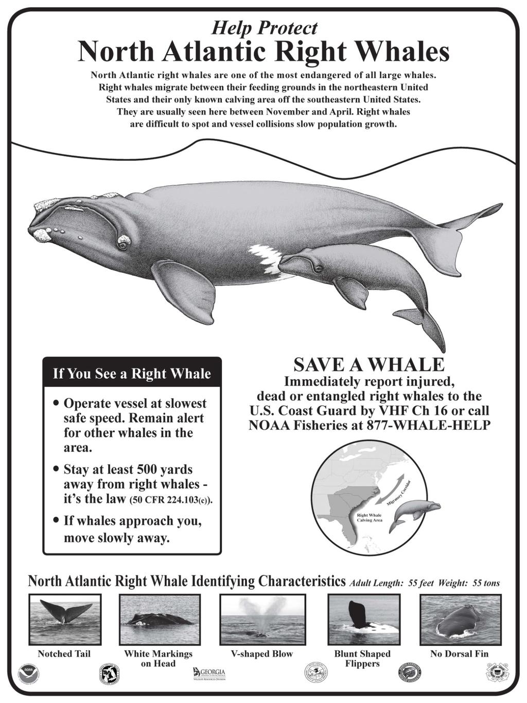
291 291
292 292
Information to assist in compliance with Nationwide Permit General Condition 18, Endangered Species
 Information to assist in compliance with Nationwide Permit General Condition 18, Endangered Species This document implements one of the protective measures identified in the November 24, 2014, programmatic
January ADDENDUM Responses to US Fish and Wildlife Service Comments. US Army Corps of Engineers Savannah District South Atlantic Division
 ENVIRONMENTAL IMPACT STATEMENT APPENDIX B: Biological Assessment of Threatened and Endangered Species SAVANNAH HARBOR EXPANSION PROJECT Chatham County, Georgia and Jasper County, South Carolina January
Dredging and Threatened/Endangered Species in the Southeastern US
 Dredging and Threatened/Endangered Species in the Southeastern US DENA DICKERSON ERDC, Environmental Lab U.S. Army Corps of Engineers Vicksburg, Mississippi Southeastern US Southeastern US USACE DISTRICTS
Southeast Regional Office th Avenue South. Ref.: SAJ , Town of Longboat Key, North End Groin Construction, Manatee County, Florida
 UNITED STATES DEPARTMENT OF COMMERCE National Oceanic and Atmospheric Administration NATIONAL MARINE FISHERIES SERVICE Southeast Regional Office 263 13th Avenue South St. Petersburg, Florida 33701-5505
ATTACHMENT NO. 35 ENDANGERED SPECIES PROTECTION PLAN
 ATTACHMENT NO. 35 ENDANGERED SPECIES PROTECTION PLAN ATTACHMENT NO. 35 ENDANGERED SPECIES PROTECTION PLAN The following conservation measures will be implemented in order to protect endangered species
AGENCY: National Marine Fisheries Service (NOAA Fisheries), National Oceanic. SUMMARY: NOAA Fisheries is closing the waters of Pamlico Sound, NC, to
, National Oceanic. SUMMARY: NOAA Fisheries is closing the waters of Pamlico Sound, NC, to") BILLING CODE 3510-22-S DEPARTMENT OF COMMERCE National Oceanic and Atmospheric Administration 50 CFR Part 223 [Docket No. 010926236-2199-02; I.D. 081202B] RIN 0648-AP63 Sea Turtle Conservation; Restrictions
BILLING CODE 3510-22-S DEPARTMENT OF COMMERCE National Oceanic and Atmospheric Administration 50 CFR Part 223 [Docket No. 010926236-2199-02; I.D. 081202B] RIN 0648-AP63 Sea Turtle Conservation; Restrictions
Dredging Impacts on Sea Turtles in the Southeastern USA Background Southeastern USA Sea Turtles Endangered Species Act Effects of Dredging on Sea Turt
 An Update on Dredging Impacts on Sea Turtles in the Southeastern t USA A Historical Review of Protection and An Introduction to the USACE Sea Turtle Data Warehouse D. Dickerson U.S. Army Corps of Engineers
Endangered Species Act: 2014 and Beyond. Wayne D Angelo Kelley Drye & Warren, LLP Washington, D.C.
 Endangered Species Act: 2014 and Beyond Wayne D Angelo Kelley Drye & Warren, LLP Washington, D.C. Endangered Species Act (16 USC 1531 et seq. (1973)) Statute for the protection of threatened and endangered
An Overview of Protected Species Commonly Found in the Gulf of Mexico. NOAA Fisheries Service Southeast Regional Office Protected Resources Division
 An Overview of Protected Species Commonly Found in the Gulf of Mexico NOAA Fisheries Service Southeast Regional Office Protected Resources Division Revised December 2006 Introduction PROTECTED SPECIES
July 9, BY ELECTRONIC MAIL Submitted via
 BY ELECTRONIC MAIL Submitted via http://www.regulations.gov Michael Barnette Attn: 0648-BC10 Southeast Regional Office National Marine Fisheries Service 263 13 th Ave South St. Petersburg, FL 33701 Dear
Endangered Species Act - Section 7 Consultation Biological Opinion
 Endangered Species Act - Section 7 Consultation Biological Opinion Agency: Activity: Consulting Agency: Date Issued: National Oceanic and Atmospheric Administration (NOAA), National Marine Fisheries Service
Types of Data. Bar Chart or Histogram?
 Types of Data Name: Univariate Data Single-variable data where we're only observing one aspect of something at a time. With single-variable data, we can put all our observations into a list of numbers.
EFFECTIVENESS OF RELOCATION TRAWLING DURING HOPPER DREDGING FOR REDUCING INCIDENTAL TAKE OF SEA TURTLES
 EFFECTIVENESS OF RELOCATION TRAWLING DURING HOPPER DREDGING FOR REDUCING INCIDEAL TAKE OF SEA TURTLES Dena Dickerson 1, Craig Theriot 2, Monica Wolters 3, Chris Slay 4, Trish Bargo 5, Will Parks 6 ABSTRACT
Exceptions to prohibitions relating to sea turtles.
 223.206 Exceptions to prohibitions relating to sea turtles. (d) Exception for incidental taking. The prohibitions against taking in 223.205(a) do not apply to the incidental take of any member of a threatened
Certification Determination for Mexico s 2013 Identification for Bycatch of North Pacific Loggerhead Sea Turtles. August 2015
 Addendum to the Biennial Report to Congress Pursuant to Section 403(a) of the Magnuson-Stevens Fishery Conservation and Management Reauthorization Act of 2006 Certification Determination for Mexico s 2013
An Evaluation of Environmental Windows on Dredging Projects in Florida, USA
 An Evaluation of Environmental Windows on Dredging Projects in Florida, USA Terri Jordan-Sellers and Aubree Hershorin, Ph.D. Coastal Section, Environmental Branch Florida Shore and Beach Technical Meeting
Volusia County Lighting Ordinance
 Volusia County Lighting Ordinance DIVISION 12. SEA TURTLE PROTECTIO N* Article III. Land Development Regulations Chapter 72 Land Planning Part II Code of Ordinances County of Volusia, Florida *Code reference--environmental
USACE Hopper Dredging Interactions with Sea Turtles: FY07 Annual Summary Report For the Northern Gulf of Mexico Region
 USACE Hopper Dredging Interactions with Sea Turtles: FY07 Annual Summary Report For the Northern Gulf of Mexico Region PREPARED BY: Dena D. Dickerson Monica S. Wolters Craig. T. Theriot Sensitive Species
Who Really Owns the Beach? The Competition Between Sea Turtles and the Coast Renee C. Cohen
 Who Really Owns the Beach? The Competition Between Sea Turtles and the Coast Renee C. Cohen Some Common Questions Microsoft Word Document This is an outline of the speaker s notes in Word What are some
IN THE UNITED STATES DISTRICT COURT FOR THE NORTHERN DISTRICT OF FLORIDA
 Case 1:09-cv-00259-SPM-AK Document 1 Filed 12/17/09 Page 1 of 31 IN THE UNITED STATES DISTRICT COURT FOR THE NORTHERN DISTRICT OF FLORIDA CARIBBEAN CONSERVATION CORPORATION; CENTER FOR BIOLOGICAL DIVERSITY;
Unacceptable Violations of Sea Turtle Protections in the U.S. Shrimp Fishery July 19, 2011
 Unacceptable Violations of Sea Turtle Protections in the U.S. Shrimp Fishery July 19, 2011 The U.S. shrimp fishery catches more sea turtles than any other U.S. fishery. The use of Turtle Excluder Devices
7/ y Reg. Endangered Species Act - Section 7 Consultation Biological Opinion I /
 Endangered Species Act - Section 7 Consultation Biological Opinion Agency: National Oceanic and Atmospheric Administration (NOAA), National Marine Fisheries Service (NMFS), Southeast Regional Office (SERO)
Appendix 10. Amendment to Biological Assessment of the Folly Beach Storm Damage Reduction Renourishment
 Appendix 10 Amendment to Biological Assessment of the Folly Beach Storm Damage Reduction Renourishment Project November 2017 NOVEMBER 2017 AMENDMENT TO: BIOLOGICAL ASSESSMENT OF THE FOLLY BEACH STORM DAMAGE
Turtle Excluder Device Regulatory History NOAA SEDAR-PW6-RD July 2014
 Turtle Excluder Device Regulatory History NOAA SEDAR-PW6-RD60 23 July 2014 APPENDIX I Turtle Excluder Device Regulation History 1970: Hawksbill, Kemp s ridley, and leatherback sea turtles are listed by
Endangered Species Origami
 Endangered Species Origami For most of the wild things on Earth, the future must depend upon the conscience of mankind ~ Dr. Archie Carr, father of modern marine turtle biology and conservation Humpback
Florida s Wildlife Contingency Plan for Oil Spill Response June 2012 Sea Turtle Guidelines for Oil Spill Response
 Sea Turtle Nesting Beach Survey and Sea Turtle and Nest Protection Protocols for Florida This document addresses loggerhead (Caretta caretta), green (Chelonia mydas), hawksbill (Eretmochelys imbricata),
Ref.: Amendment of the November 2011, Savannah Harbor Expansion Project Biological Opinion, Savannah, Georgia
 UNITED STATES DEPARTMENT OF COMMERCE National Oceanic and Atmospheric Administration NATIONAL MARINE FISHERIES SERVICE Southeast Regional Office 263 13th Avenue South St. Petersburg. Florida 33701-5505
Mississippi Shrimp Summary Action Plan Marine Advancement Plan (MAP)
") Mississippi Shrimp Summary Action Plan Marine Advancement Plan (MAP) Updated March 2017 Prepared by: Audubon Nature Institute Gulf United for Lasting Fisheries (G.U.L.F.) Laura Picariello - Technical Programs
Mississippi Shrimp Summary Action Plan Marine Advancement Plan (MAP) Updated March 2017 Prepared by: Audubon Nature Institute Gulf United for Lasting Fisheries (G.U.L.F.) Laura Picariello - Technical Programs
Update on Federal Shrimp Fishery Management in the Southeast
 Update on Federal Shrimp Fishery Management in the Southeast Southeast Region David Bernhart NOAA Fisheries American Shrimp Processors Association Meeting Biloxi, MS April 7, 2017 Outline SERO Stock Status
HABITAT CONSERVATION PLAN A PLAN FOR THE PROTECTION OF SEA TURTLES ON ERODING BEACHES IN INDIAN RIVER COUNTY, FLORIDA
 A PLAN FOR THE PROTECTION OF SEA TURTLES ON ERODING BEACHES IN INDIAN RIVER COUNTY, FLORIDA Prepared for Indian River County Public Works Department 1840 25 th Street Vero Beach, Florida 32960 Prepared
Conservation Sea Turtles
 Conservation of Sea Turtles Regional Action Plan for Latin America and the Caribbean Photo: Fran & Earle Ketley Rare and threatened reptiles Each day appreciation grows for the ecological roles of sea
13 Chapter 13: Sea Turtle Early Restoration Project
 13 Chapter 13: Sea Turtle Early Restoration Project 13.1 13.2 13.3 Sea Turtle Early Restoration Project: Project Description... 1 13.1.1 Introduction... 1 13.1.2 Project Summary... 2 13.1.3 Background
I. Proposed New TED Regulations Will Have Huge Adverse Economic Consequences for Gulf of Mexico Coastal Communities:
 LOUISIANA SHRIMP ASSOCIATION P.O. Box 1088 Grand Isle, La. 70358 504-382-9341 Sea Turtle Environmental Impact Statement WRITTEN COMMENT REGARDING PROPOSED SHRIMP TRAWLING REQUIREMENTS RIN 0648-BG45 VIA
Alabama Shrimp Summary Action Plan Marine Advancement Plan (MAP)
") Alabama Shrimp Summary Action Plan Marine Advancement Plan (MAP) Updated March 2017 Prepared by: Audubon Nature Institute Gulf United for Lasting Fisheries (G.U.L.F.) Laura Picariello - Technical Programs
Alabama Shrimp Summary Action Plan Marine Advancement Plan (MAP) Updated March 2017 Prepared by: Audubon Nature Institute Gulf United for Lasting Fisheries (G.U.L.F.) Laura Picariello - Technical Programs
DEP 1998 MODEL LIGHTING ORDINANCE FOR MARINE 62B-55 TURTLE PROTECTION CHAPTER 62B-55 MODEL LIGHTING ORDINANCE FOR MARINE TURTLE PROTECTION INDEX PAGE
 CHAPTER 62B-55 MODEL LIGHTING ORDINANCE FOR MARINE INDEX PAGE 62B-55.001 PURPOSE AND INTENT...1 62B-55.002 DEFINITIONS....1 62B-55.003 MARINE TURTLE NESTING AREAS....2 62B-55.004 GENERAL GUIDANCE TO LOCAL
DEPARTMENT OF THE ARMY JACKSONVILLE DISTRICT CORPS OF ENGINEERS
 DEPARTMENT OF THE ARMY JACKSONVILLE DISTRICT CORPS OF ENGINEERS P. O. BOX 4970 JACKSONVILLE, FLORIDA 32232-0019 REPLY TO ATTENTION OF FINDING OF NO SIGNIFICANT IMPACT Supplemental Sand Source for Sand
10/12/2012. Statement of Proposed Alternative
 Aleutians East Borough Proposed Alternative 4 for Steller Sea Lion Mitigation Measures in the current EIS. Submitted for Consideration by the North Pacific Fishery Management Council Steller Sea Lion Mitigation
Via U.S. Mail and Electronic Mail
 Caribbean Conservation Corporation Center for Biological Diversity Defenders of Wildlife Earthjustice Gulf Restoration Network Turtle Island Restoration Network Via U.S. Mail and Electronic Mail Honorable
Legal Supplement Part B Vol. 53, No th March, NOTICE THE ENVIRONMENTALLY SENSITIVE SPECIES (GREEN TURTLE) NOTICE, 2014
 NOTICE, 2014") Legal Supplement Part B Vol. 53, No. 37 28th March, 2014 211 LEGAL NOTICE NO. 90 REPUBLIC OF TRINIDAD AND TOBAGO THE ENVIRONMENTAL MANAGEMENT ACT, CHAP. 35:05 NOTICE MADE BY THE ENVIRONMENTAL MANAGEMENT
Legal Supplement Part B Vol. 53, No. 37 28th March, 2014 211 LEGAL NOTICE NO. 90 REPUBLIC OF TRINIDAD AND TOBAGO THE ENVIRONMENTAL MANAGEMENT ACT, CHAP. 35:05 NOTICE MADE BY THE ENVIRONMENTAL MANAGEMENT
IN-WATER SEA TURTLE DISTRIBUTION AND ABUNDANCE MONITORING ON PALM BEACH COUNTY NEARSHORE REEFS FOR:
 IN-WATER SEA TURTLE DISTRIBUTION AND ABUNDANCE MONITORING ON PALM BEACH COUNTY NEARSHORE REEFS FOR: Jupiter Carlin Shoreline Protection Project Juno Beach Shoreline Protection Project Singer Island Erosion
EFFECTS OF THE DEEPWATER HORIZON OIL SPILL ON SEA TURTLES
 EFFECTS OF THE DEEPWATER HORIZON OIL SPILL ON SEA TURTLES BRYAN WALLACE (DWH NATURAL RESOURCE DAMAGE ASSESSMENT SEA TURTLE TECHNICAL WORKING GROUP) Acknowledgements Many, many organizations and individuals
CHAPTER 14: MONITORING AND MANAGEMENT OF LISTED SPECIES
 CHAPTER 14: MONITORING AND MANAGEMENT OF LISTED SPECIES Biological Goal The beaches of Walton County provide important nesting habitat for four species of sea turtles, year-round habitat for CBM, and foraging
Oil Spill Impacts on Sea Turtles
 Oil Spill Impacts on Sea Turtles which were the Kemp s ridleys. The five species of sea turtles that exist in the Gulf were put greatly at risk by the Gulf oil disaster, which threatened every stage of
Eelgrass in Narragansett Bay: A Case Study
 Eelgrass in Narragansett Bay: A Case Study An activity developed by Kristin Van Wagner, Education Coordinator for the Narragansett Bay Research Reserve based on Prudence Island, Rhode Island (www.nbnerr.org)
1995 Activities Summary
 Marine Turtle Tagging Program Tagging Data for Nesting Turtles and Netted & Released Turtles 199 Activities Summary Submitted to: NMFS - Miami Lab Cooperative Marine Turtle Tagging Program 7 Virginia Beach
SEA TURTLE MOVEMENT AND HABITAT USE IN THE NORTHERN GULF OF MEXICO
 SEA TURTLE MOVEMENT AND HABITAT USE IN THE NORTHERN GULF OF MEXICO Kristen M. Hart, Ph.D., Research Ecologist, USGS Wetland and Aquatic Research Center, Davie, FL Margaret M. Lamont, Ph.D., Biologist,
Convention on the Conservation of Migratory Species of Wild Animals
 MEMORANDUM OF UNDERSTANDING ON THE CONSERVATION AND MANAGEMENT OF MARINE TURTLES AND THEIR HABITATS OF THE INDIAN OCEAN AND SOUTH-EAST ASIA Concluded under the auspices of the Convention on the Conservation
ENDANGERED SPECIES ACT SECTION 7 CONSULTATION BIOLOGICAL OPINION. Bureau of Ocean Energy Management Army Corps of Engineers, New England District
 ENDANGERED SPECIES ACT SECTION 7 CONSULTATION BIOLOGICAL OPINION Action Agency: Activity: Bureau of Ocean Energy Management Army Corps of Engineers, New England District Commercial Wind Lease Issuance
Recognizing that the government of Mexico lists the loggerhead as in danger of extinction ; and
 RESOLUTION URGING THE REPUBLIC OF MEXICO TO END HIGH BYCATCH MORTALITY AND STRANDINGS OF NORTH PACIFIC LOGGERHEAD SEA TURTLES IN BAJA CALIFORNIA SUR, MEXICO Recalling that the Republic of Mexico has worked
Submitted via erulemaking Portal
 Submitted via erulemaking Portal Chris Fanning NMFS West Coast Region 501 W. Ocean Blvd., Suite 4200 Long Beach, CA 90802 https://www.regulations.gov/#!docketdetail;d=noaa-nmfs-2016-0022 March 31, 2016
Jupiter/Carlin Nourishment A Case of Adaptive Management, Cooperation and Innovative Applications
 Jupiter/Carlin Nourishment A Case of Adaptive Management, Cooperation and Innovative Applications Michael Stahl and Kelly Martin National Conference on Beach Preservation Technology February 4, 2016 Jupiter/Carlin
Via Electronic Submittal
 Shore Protection Manager Greg L. Rudolph Tel: (252) 393.2663 Fax: (252) 393.6639 rudi@carteretcountygov.org May 22, 2013 Via Electronic Submittal Public Comments Processing, Attn: FWS-R4-ES-2012-0103 Division
What s In An Inch? The Case for Requiring Improved Turtle Excluder Devices in All U.S. Shrimp Trawls
 What s In An Inch? The Case for Requiring Improved Turtle Excluder Devices in All U.S. Shrimp Trawls 1 Steve DeNeef Authors: Mariah Pfleger, Kara Shervanick and Lora Snyder The authors would like to thank
2015 Annual Determination to Implement the Sea Turtle Observer Requirement
 This document is scheduled to be published in the Federal Register on 03/19/2015 and available online at http://federalregister.gov/a/2015-06341, and on FDsys.gov Billing Code: 3510-22-P DEPARTMENT OF
CHARACTERISTIC COMPARISON. Green Turtle - Chelonia mydas
 5 CHARACTERISTIC COMPARISON Green Turtle - Chelonia mydas Green turtles average 1.2m to 1.4m in length, are between 120kg to 180kg in weight at full maturity and found in tropical and sub-tropical seas
Legal Supplement Part B Vol. 53, No th March, NOTICE THE ENVIRONMENTALLY SENSITIVE SPECIES (OLIVE RIDLEY TURTLE) NOTICE, 2014
 NOTICE, 2014") Legal Supplement Part B Vol. 53, No. 37 28th March, 2014 227 LEGAL NOTICE NO. 92 REPUBLIC OF TRINIDAD AND TOBAGO THE ENVIRONMENTAL MANAGEMENT ACT, CHAP. 35:05 NOTICE MADE BY THE ENVIRONMENTAL MANAGEMENT
Legal Supplement Part B Vol. 53, No. 37 28th March, 2014 227 LEGAL NOTICE NO. 92 REPUBLIC OF TRINIDAD AND TOBAGO THE ENVIRONMENTAL MANAGEMENT ACT, CHAP. 35:05 NOTICE MADE BY THE ENVIRONMENTAL MANAGEMENT
NETHERLANDS ANTILLES ANTILLAS HOLANDESAS
 THE AD HOC DATA REPORT EL REPORTE DE DATOS AD HOC FOR THE COUNTRY OF POR EL PAIS DE NETHERLANDS ANTILLES ANTILLAS HOLANDESAS PREPARED BY/ PREPARADO POR GERARD VAN BUURT Western Atlantic Turtle Symposium
Marine Reptiles. Four types of marine reptiles exist today: 1. Sea Turtles 2. Sea Snakes 3. Marine Iguana 4. Saltwater Crocodile
 Marine Reptiles Four types of marine reptiles exist today: 1. Sea Turtles 2. Sea Snakes 3. Marine Iguana 4. Saltwater Crocodile Sea Turtles All species of sea turtles are threatened or endangered Endangered
EYE PROTECTION BIFOCAL SAFETY GLASSES ANSI Z87.1 ANSI Z87.1 ANSI Z87.1 SAFETY GOGGLE MODEL # TYG 400 G SAFETY GOGGLE MODEL # TYG 405 SAFETY GOGGLE
 EYE PROTECTION TY700-F Bifocal Safety Glasses EN166 TY701-SF Safety Glasses EN166 Removeable & soft foam inner frame provides comfortable fit Anti-fog and anti-scratch treated lenses Trendy & Sporty style,
INDIA. Sea Turtles along Indian coast. Tamil Nadu
 Dr. A. Murugan Suganthi Devadason Marine Research Institute 44-Beach Road, Tuticorin-628 001 Tamil Nadu, India Tel.: +91 461 2323007, 2336487 Fax: +91 461 2325692 E-mail: muruganrsa@sancharnet sancharnet.in
Louisiana Shrimp Fishery Improvement Plan Sea Turtles
 Louisiana Shrimp Fishery Improvement Plan Sea Turtles Several protected species are found in Louisiana waters, including five species of sea turtles. These protected resources are regulated by the U.S.
IN THE UNITED STATES DISTRICT COURT FOR THE EASTERN DISTRICT OF NORTH CAROLINA EASTERN DIVISION. CIVIL ACTION NO.: 4:14-cv-138
 IN THE UNITED STATES DISTRICT COURT FOR THE EASTERN DISTRICT OF NORTH CAROLINA EASTERN DIVISION CIVIL ACTION NO.: 4:14-cv-138 NORTH CAROLINA FISHERIES ) ASSOCIATION, INC.; and ) CARTERET COUNTY FISHERMAN
Response to SERO sea turtle density analysis from 2007 aerial surveys of the eastern Gulf of Mexico: June 9, 2009
 Response to SERO sea turtle density analysis from 27 aerial surveys of the eastern Gulf of Mexico: June 9, 29 Lance P. Garrison Protected Species and Biodiversity Division Southeast Fisheries Science Center
Let s Protect Sri Lankan Coastal Biodiversity
 Let s Protect Sri Lankan Coastal Biodiversity Bio Conservation Society (BCSL) - Sri Lanka 0 Annual Report 2017 We work with both adult and children for the conservation of Sri Lankan Coastal Biodiversity!
8456 Federal Register / Vol. 68, No. 35 / Friday, February 21, 2003 / Rules and Regulations
 8456 Federal Register / Vol. 68, No. 35 / Friday, February 21, 2003 / Rules and Regulations the clause at 252.232 7003) fulfills the requirement for a material inspection and receiving report (DD Form
Andaman & Nicobar Islands
 Map showing and Nicobar Dr. A. Murugan Suganthi Devadason Marine Research Institute 44-Beach Road, Tuticorin-628 001, India Tel.: +91 461 2336488; Fax: +91 461 2325692 & Nicobar Location: 6 45 N to 13
Notice of Intent to Sue for Violations of the Endangered Species Act Related to the Management of the Gulf of Mexico Shrimp Trawl Fishery
 July 19, 2011 Sent via certified mail and electronic mail Honorable Gary Locke Secretary of Commerce U.S. Department of Commerce 1401 Constitution Avenue, N.W., Rm 5516 Washington, D.C. 20230 TheSec@doc.gov
Field report to Belize Marine Program, Wildlife Conservation Society
 Field report to Belize Marine Program, Wildlife Conservation Society Cathi L. Campbell, Ph.D. Nicaragua Sea Turtle Conservation Program, Wildlife Conservation Society May 2007 Principal Objective Establish
United States Department ofthe Interior
 United States Department ofthe Interior ~ FISH AND WILDLIFE SERVICE South Florida Ecological Services Office 1339 20'h Street Vero Beach, Florida 32960 u.s. FISH WILDLIFE SERVICE June 28, 2013 Colonel
Bycatch records of sea turtles obtained through Japanese Observer Program in the IOTC Convention Area
 Bycatch records of sea turtles obtained through Japanese Observer Program in the IOTC Convention Area Kei Okamoto and Kazuhiro Oshima National Research Institute of Far Seas Fisheries, Japan Fisheries
American Samoa Sea Turtles
 American Samoa Sea Turtles Climate Change Vulnerability Assessment Summary An Important Note About this Document: This document represents an initial evaluation of vulnerability for sea turtles based on
GNARALOO TURTLE CONSERVATION PROGRAM 2011/12 GNARALOO CAPE FARQUHAR ROOKERY REPORT ON SECOND RECONNAISSANCE SURVEY (21 23 JANUARY 2012)
") GNARALOO TURTLE CONSERVATION PROGRAM 2011/12 GNARALOO CAPE FARQUHAR ROOKERY REPORT ON SECOND RECONNAISSANCE SURVEY (21 23 JANUARY 2012) By Karen Hattingh, Kimmie Riskas, Robert Edman and Fiona Morgan 1.
GNARALOO TURTLE CONSERVATION PROGRAM 2011/12 GNARALOO CAPE FARQUHAR ROOKERY REPORT ON SECOND RECONNAISSANCE SURVEY (21 23 JANUARY 2012) By Karen Hattingh, Kimmie Riskas, Robert Edman and Fiona Morgan 1.
MANAGING MEGAFAUNA IN INDONESIA : CHALLENGES AND OPPORTUNITIES
 MANAGING MEGAFAUNA IN INDONESIA : CHALLENGES AND OPPORTUNITIES By Dharmadi Agency for Marine and Fisheries Research Ministry of Marine Affairs and Fisheries Republic of Indonesia MEGAFAUNA I. SEA TURTLES
GNARALOO TURTLE CONSERVATION PROGRAM 2011/12 GNARALOO CAPE FARQUHAR ROOKERY REPORT ON FINAL RECONNAISSANCE SURVEY (21 23 FEBRUARY 2012)
") GNARALOO TURTLE CONSERVATION PROGRAM 211/12 GNARALOO CAPE FARQUHAR ROOKERY REPORT ON FINAL RECONNAISSANCE SURVEY (21 23 FEBRUARY 212) By Karen Hattingh, Kimmie Riskas, Robert Edman and Fiona Morgan 1.
GNARALOO TURTLE CONSERVATION PROGRAM 211/12 GNARALOO CAPE FARQUHAR ROOKERY REPORT ON FINAL RECONNAISSANCE SURVEY (21 23 FEBRUARY 212) By Karen Hattingh, Kimmie Riskas, Robert Edman and Fiona Morgan 1.
GUIDELINES FOR DEVELOPING A POTENTIAL BIOLOGICAL REMOVAL (PBR) FRAMEWORK FOR MANAGING SEA TURTLE BYCATCH IN THE PAMLICO SOUND FLOUNDER GILLNET FISHERY
 FRAMEWORK FOR MANAGING SEA TURTLE BYCATCH IN THE PAMLICO SOUND FLOUNDER GILLNET FISHERY") GUIDELINES FOR DEVELOPING A POTENTIAL BIOLOGICAL REMOVAL (PBR) FRAMEWORK FOR MANAGING SEA TURTLE BYCATCH IN THE PAMLICO SOUND FLOUNDER GILLNET FISHERY by Nancy Young Masters project submitted in partial
GUIDELINES FOR DEVELOPING A POTENTIAL BIOLOGICAL REMOVAL (PBR) FRAMEWORK FOR MANAGING SEA TURTLE BYCATCH IN THE PAMLICO SOUND FLOUNDER GILLNET FISHERY by Nancy Young Masters project submitted in partial
HABITAT CONSERVATION PLAN FOR THE PROTECTION OF SEA TURTLES ON THE ERODING BEACHES OF INDIAN RIVER COUNTY, FLORIDA ANNUAL REPORT
 HABITAT CONSERVATION PLAN FOR THE PROTECTION OF SEA TURTLES ON THE ERODING BEACHES OF INDIAN RIVER COUNTY, FLORIDA ANNUAL REPORT - 2007 Prepared in Support of Indian River County s Incidental Take Permit
Florida Fish and Wildlife Conservation Commission Fish and Wildlife Research Institute Guidelines for Marine Turtle Permit Holders
 Florida Fish and Wildlife Conservation Commission Fish and Wildlife Research Institute Guidelines for Marine Turtle Permit Holders Nesting Beach Surveys TOPIC: CRAWL IDENTIFICATION GLOSSARY OF TERMS: Crawl
REQUEST FOR STATEMENTS OF INTEREST SOUTH FLORIDA-CARIBBEAN CESU NETWORK NUMBER W912HZ-16-SOI-0007 PROJECT TO BE INITIATED IN FY 2016
 REQUEST FOR STATEMENTS OF INTEREST SOUTH FLORIDA-CARIBBEAN CESU NETWORK NUMBER W912HZ-16-SOI-0007 PROJECT TO BE INITIATED IN FY 2016 Project Title: Evaluating Alligator Status as a System-wide Ecological
SEA TURTLE CHARACTERISTICS
 SEA TURTLE CHARACTERISTICS There are 7 species of sea turtles swimming in the world s oceans. Sea turtles are omnivores, meaning they eat both plants and animals. Some of their favorite foods are jellyfish,
Freeport Harbor Channel Improvement Project, Brazoria County, Texas Final Integrated General Reevaluation Report and Environmental Assessment
 Freeport Harbor Channel Improvement Project, Brazoria County, Texas Final Integrated General Reevaluation Report and Environmental Assessment Appendix H Biological Assessment Endangered Species Act Coordination
CONSERVATION AND MANAGEMENT PLAN
 CONSERVATION AND MANAGEMENT PLAN Objective 1. Reduce direct and indirect causes of marine turtle mortality 1.1 Identify and document the threats to marine turtle populations and their habitats a) Collate
Loggerhead Turtles: Creature Feature
 Loggerhead Turtles: Creature Feature These beautifully colored sea turtles got their name because their oversized head sort of looks like a big log. Within their heads are powerful jaws, which loggerheads
The state of conservation of sea turtles in the Mediterranean- case study of Greece
 The state of conservation of sea turtles in the Mediterranean- case study of Greece Panagiota Theodorou Conservation Coordinator ARCHELON, the Sea Turtle Protection Society of Greece Greece www.archelon.gr
Puna Lava Zone - Marine Resource Reconnaissance Survey Preliminary Report Prepared by Kallie Barnes / Hawai i Wildlife Fund 28 September 2018
 Puna Lava Zone - Marine Resource Reconnaissance Survey Preliminary Report Prepared by Kallie Barnes / Hawai i Wildlife Fund 28 September 2018 INTRODUCTION On May 3rd 2018 the Kīlauea Volcano erupted in
STATE OF CALIFORNIA FISH AND GAME COMMISSION FINAL STATEMENT OF REASONS FOR REGULATORY ACTION
 STATE OF CALIFORNIA FISH AND GAME COMMISSION FINAL STATEMENT OF REASONS FOR REGULATORY ACTION Amend Section 124 Title 14, California Code of Regulations Re: Definition of Light Touch Trawl Gear for Use
REPORT / DATA SET. National Report to WATS II for the Cayman Islands Joe Parsons 12 October 1987 WATS2 069
 WATS II REPORT / DATA SET National Report to WATS II for the Cayman Islands Joe Parsons 12 October 1987 WATS2 069 With a grant from the U.S. National Marine Fisheries Service, WIDECAST has digitized the
Marine Turtle Surveys on Diego Garcia. Prepared by Ms. Vanessa Pepi NAVFAC Pacific. March 2005
 Marine Turtle Surveys on iego Garcia Prepared by Ms. Vanessa Pepi NAVFAC Pacific March 2005 Appendix K iego Garcia Integrated Natural Resources Management Plan April 2005 INTROUCTION This report describes
Sea Turtles and Longline Fisheries: Impacts and Mitigation Experiments
 Sea Turtles and Longline Fisheries: Impacts and Mitigation Experiments Yonat Swimmer, Mike Musyl, Lianne M c Naughton, Anders Nielson, Richard Brill, Randall Arauz PFRP P.I. Meeting Dec. 9, 2003 Species
Rio Tinto Alcan Weipa. Temporary Barge Plan. July 2015
 Rio Tinto Alcan Weipa Temporary Barge Plan July 2015 DOCUMENT CONTROL Version Purpose Approval Submission Date Final For approval by DoE Submitted 18 December 2014 Final Response to Comments from DoE Final
RELATIVE ABUNDANCE OF JUVENILE SMALL TOOTH SAWFISH
 Final Report RELATIVE ABUNDANCE OF JUVENILE SMALL TOOTH SAWFISH Beau G. Yeiser and Tonya Wiley* Center for Shark Research Mote Marine Laboratory 1600 Ken Thompson Parkway Sarasota, FL 34236 NOAA purchase
Via Facsimile and Certified Mail/Return Receipt Requested
 CENTER for BIOLOGICAL DIVERSITY Because life is good. Via Facsimile and Certified Mail/Return Receipt Requested June 29, 2010 Tony Hayward Chief Executive Officer BP America, Inc. 501 Westlake Park Blvd.
Allowable Harm Assessment for Leatherback Turtle in Atlantic Canadian Waters
 Maritimes Lead: Stock Status Report 2004/035 Allowable Harm Assessment for in Atlantic Canadian Waters Background The leatherback turtle (Dermochelys coriacea) is designated as endangered by the Committee
Human Impact on Sea Turtle Nesting Patterns
 Alan Morales Sandoval GIS & GPS APPLICATIONS INTRODUCTION Sea turtles have been around for more than 200 million years. They play an important role in marine ecosystems. Unfortunately, today most species
Sea Turtle, Terrapin or Tortoise?
 Sea Turtles Sea Turtle, Terrapin or Tortoise? Based on Where it lives (ocean, freshwater or land) Retraction of its flippers and head into its shell All 3 lay eggs on land All 3 are reptiles Freshwater
Pikas. Pikas, who live in rocky mountaintops, are not known to move across non-rocky areas or to
 Pikas, who live in rocky mountaintops, are not known to move across non-rocky areas or to A pika. move long distances. Many of the rocky areas where they live are not close to other rocky areas. This means
OPINIONS BY MARK C. JORGENSEN MAY 2, 2012
 COMMENTS ON THE BIOLOGICAL OPINION (BO) OF THE US FISH & WILDLIFE SERVICE (USF&WS) TO THE BUREAU OF LAND MANAGEMENT (BLM) REGARDING THE OCOTILLO WIND ENERGY FACILITY OPINIONS BY MARK C. JORGENSEN MAY 2,
RESEARCH AND CONSERVATION AT GEORGIA AQUARIUM, INC.
 RESEARCH AND CONSERVATION AT GEORGIA AQUARIUM, INC. Georgia Aquarium is committed to the research and conservation of aquatic animals around the world. As a leader in marine research, Georgia Aquarium
Sent via . April 29, 2016
 Sent via email April 29, 2016 Mr. Michael Barnette Southeast Regional Office Protected Resources Division National Marine Fisheries Service 263 13 th Avenue South St. Petersburg, FL 33701-5505 Michael.Barnette@noaa.gov
RECOMMENDED STANDARD MITIGATION MEASURES FOR PROJECTS IN SONORAN DESERT TORTOISE HABITAT
 RECOMMENDED STANDARD MITIGATION MEASURES FOR PROJECTS IN SONORAN DESERT TORTOISE HABITAT Arizona Interagency Desert Tortoise Team June 2008 The following mitigation process and measures are recommended
A Guide to Living with. Crocodiles. Bill Billings
 A Guide to Living with Crocodiles Bill Billings The American crocodile, bottom left, has a narrow, tapered snout. The alligator, top right, has a broad, rounded snout. American Crocodiles in Florida Historically,