Mayflower, Arkansas Comprehensive Plan 2012
|
|
|
- Meryl Turner
- 5 years ago
- Views:
Transcription

1 Mayflower, Arkansas Comprehensive Plan 2012
2 The preparation and publication of this document was financed in part by federal funds provided by the U.S. Department of Transportation through the Federal Highway Administration and Federal Transit Administration. The provision of federal financial assistance should not be construed as denoting federal agency approval of any plans, policies or projects contained herein.
3 Table of Contents List of Tables... iv List of Charts... iv List of Maps... v INTRODUCTION... 1 BACKGROUND... 3 Mayflower Planning Area... 3 History... 3 Government Setting... 4 Regional Setting... 4 Physical Setting and Constraints to Development... 4 Population... 9 Ethnic Composition Age Structure Housing Population Projections Economy Community Services and Facilities DESCRIPTION OF MAYFLOWER ISSUES GOALS AND STRATEGIES LAND USE PLAN MASTER STREET PLAN REFERENCES APPENDIX A Census Tract Map iii
4 List of Tables Table 1 Sales and Millage Tax Rates by City (Faulkner County)... 4 Table 2 Mayflower Housing Statistics Table 3 Owner- versus Renter-Owned Housing Table 4 City of Mayflower Housing Types Table 5 Share of Housing Units by Year Built Table 6 Population Projections Table 7 Comparison of Mayflower Earnings with Faulkner County & MSA Table 8 Change in Number of Local Resident Workers by Earnings Category Table 9 Educational Attainment Comparison for Population Age Table 10 Faulkner County Schools Comparison of Key Statistics Table 11 Employment Sectors Ranked by Location Quotient Table 12. Estimated Unmet Retail Needs by Industry Group Table 13. Park and Recreation Facility Development Standards for Mayflower Planning Area Table 14 Arkansas Functional Classification System Table 15 Summary of Right-of-Way and Design Standards List of Charts Chart 1 Mayflower Population Trend ( ) Chart 2 Population Growth Rates by Decade: Mayflower vs.faulkner Co Chart 3 Racial Breakdown Comparison Chart 4 Median Age Chart 5 Mayflower Population by Age and Sex Chart 6 Mayflower Population by Age and Sex Chart 7 Mayflower Population by Age and Sex Chart 8 Workplace of Mayflower Residents Chart 9 Workplace of Mayflower Workers Chart 10 Share of Households by Income Chart 11 Income by Age (55-64) Chart 12 Income by Age (65+) Chart 13 Employment by Industry iv
5 List of Maps Map 1. Lake Conway and Area Attractions... 5 Map 2. Development Constraints... 7 Map 3. Mayflower Existing Land Use and Public Facilities Map 4. Mayflower Water and Fire Systems Map 5. Mayflower Wastewater System Map 6. Mayflower High Speed Internet Map 7. Mayflower School District Map 8. Critical Areas Map Map 9. Future Land Use and Master Street Plan v
6 INTRODUCTION Mayflower, Arkansas Comprehensive Plan The current comprehensive plan for the City of Mayflower was adopted by the City Council by Resolution on March 13, Since that time, Mayflower has experienced a 37% increase in population, pointing to the need for an updated comprehensive plan and associated documents. As prescribed by Arkansas law, a Planning Studies Report was prepared in the Spring of 2011 as the first step in developing a new comprehensive plan. A variety of resources were used to compile the information contained in the Planning Studies Report, including demographic information, geographic information studies, interviews with city officials and leaders, input from the public, and city documents. Specific documents used include the Master Street Plan (2004), the overlay district ordinance, the Walkable Mayflower plan (2008), and the city s Arkansas Community of Excellence Strategic Plan (2010). The new comprehensive plan was developed on the basis of these resources and with additional input from public hearings held Fall 2011/Winter The new comprehensive plan is: A public guide to decision making, An assessment of community needs, A statement of community values, goals and objectives, A guide for the community s development, and An official public document stating the public purpose of the plan. Additionally, the comprehensive plan is the basis on which the planning commission prepares and transmits to the city council the ordinances and regulations necessary to implement the plan (A.C.A. Section ). The Comprehensive Plan is divided into the following sections: Background Information Background data is provided that describes as accurately as possible the current conditions in Mayflower, and trends that are important to consider as Mayflower plans its future. Currently available and planned community facilities are discussed, including a map of Community Services and Facilities. Description of Mayflower Issues This narrative combines the input provided by residents and public officials, with the background data and other resources on how Mayflower can best plan for the future. Vision, Goals and Objectives This list of key policy directives was developed based on input from Mayflower residents and public officials. Land Use Plan The Land Use Plan lays out, in broad strokes, what kinds of development are appropriate for various areas of Mayflower. The Plan is implemented by specific zoning changes that follow. Master Street Plan The Master Street Plan designates the general location, characteristics, and functions of streets and highways, including those to be reserved for future public acquisition. 1
7
8 BACKGROUND INFORMATION Mayflower Planning Area The current Mayflower Planning Area Map was adopted by the Planning Commission in February 13, It reflects an agreement reached between the cities of Mayflower and Conway as to their common planning boundary. A meeting with Conway officials on August 2, 2011 revealed their intent to annex property in proximity to the new Interstate 40/Conway Loop interchange located in the Lawrence Landing vicinity. The planning area boundary will require adjustments following that annexation, but no other needs for adjustments were determined to be necessary at this time. History of Mayflower Mayflower was settled in 1778 by Revolutionary War Tories who moved west to get a new start. As the land along Palarm Creek and the Arkansas River was settled, the town moved north to the present area. When the railroad came to town in 1871, the town got its name, Mayflower, from the telegraph call of the railroad construction superintendent. Mayflower was also a stagecoach stop on the road from Little Rock to Clinton. With the coming of the railroad, the town grew and eventually incorporated in The community got an economic boost when Lake Conway 1 was completed in With 6,700 acres and 56 miles of shoreline, Lake Conway is the largest lake operated by the Arkansas Game and Fish Commission, and the largest lake constructed by the wildlife agency of any state. (See Map 1) By 1953, there were seven privately owned commercial landings on Lake Conway, with approximately 300 boats available for rent. Originally there was no regulation of the number of docks to be built; in 1955, the Lake Conway Dock Operators Association asked AGFC to stop issuing permits due to overcrowding. At that time (1955) there were 17 commercial landings and 6 more applications pending. Five commercial docks had cafes, two had cabins for rent. Individuals also built cabins or installed trailers for personal use, rent or sale, and several nice private homes were built on the western shore of the Lake. The rapid build-up around Lake Conway quickly led to problems, such as sewage, trash disposal, fire and police protection, mosquito control, shoreline clean-up, level of the lake, when and if to have drawdowns, water quality, and others that have influenced the development of Mayflower. In particular, the quality of the housing stock, due to the part-time nature of Lake Conway residents became a perennial problem. Known as an excellent fishing lake, Lake Conway is stocked with bass, catfish, bream and crappie. Several free public launch areas are maintained by the Arkansas Game & Fish Commission; boat rentals are available at several commercial docks on the lake. Adams, Brannon s, Bream s Nest, Gold Creek, Highway, Lawrence, Martin s Northshore, Palarm Creek, Paradise, Pierce Creek and 1 On November 17, 2011, Lake Conway was officially dedicated as the Craig D. Campbell Lake Conway Reservoir, as a tribute to one of the outgoing Arkansas Game and Fish Commissioners. Throughout this document, the lake will still continue to be referred to by its popular name, Lake Conway. 3
9 Sevier s are the landings with boat ramps. (See Map 1) Old creek channels that can be found on all sides of the lake are some of the best places to bass fish. Lake Conway is home to the Crappie Master s State Tournament in the spring ( Another economic boost to Mayflower came when Interstate 40 was constructed in However, neither the presence of Interstate 40 nor Lake Conway has led to major population growth. Mayflower is mostly known for fishing and hunting in and around Lake Conway and for its easy access to Conway and Little Rock, where most residents work. Government Setting Mayflower is a second class city under Arkansas law. The form of government is mayor-council, with six aldermen from three wards. Primary revenue sources come from state turnback money, property taxes and sales taxes. State turnback money to cities is based on population. Sales and millage tax rates must be approved by the voters in each city. Table 1 compares the sales tax and millage rates of Mayflower with other cities in Faulkner County. At 4.00, Mayflower has the second highest millage rate in the county. Until recently, the sales tax was only one percent; in 2008 an additional one percent was added, with the revenue dedicated to streets and drainage. Regional Setting Located between Little Rock and Conway on a major transportation corridor that accommodates Interstate 40, Highway 365, and the Union Pacific Railroad, Mayflower is part of the Little Rock- North Little Rock-Conway Metropolitan Statistical Area (MSA). As part of this MSA, Mayflower s growth and economic development is closely tied to business, government, medical and industrial employment opportunities in Central Arkansas. Mayflower is the closest urban area to Lake Conway. Physical Setting/Constraints to Development Table 1 Sales and Millage Tax Rates by City (Faulkner County) Sources: Department of Finance and Administration, Sales and Use Tax Section, January Millage Report, Assessment Coordination Department, June 2011 The pattern of urban development in the Mayflower area has been influenced by the physical characteristics of the land, as illustrated in Map 2. Steep slopes and flood plains constrain development on much of the land in the town. Additionally, the railroad and Interstate 40 are limiting factors. These physical constraints not only give shape to the city today, but will also 4

10 Map 1 Lake Conway Facilities
11
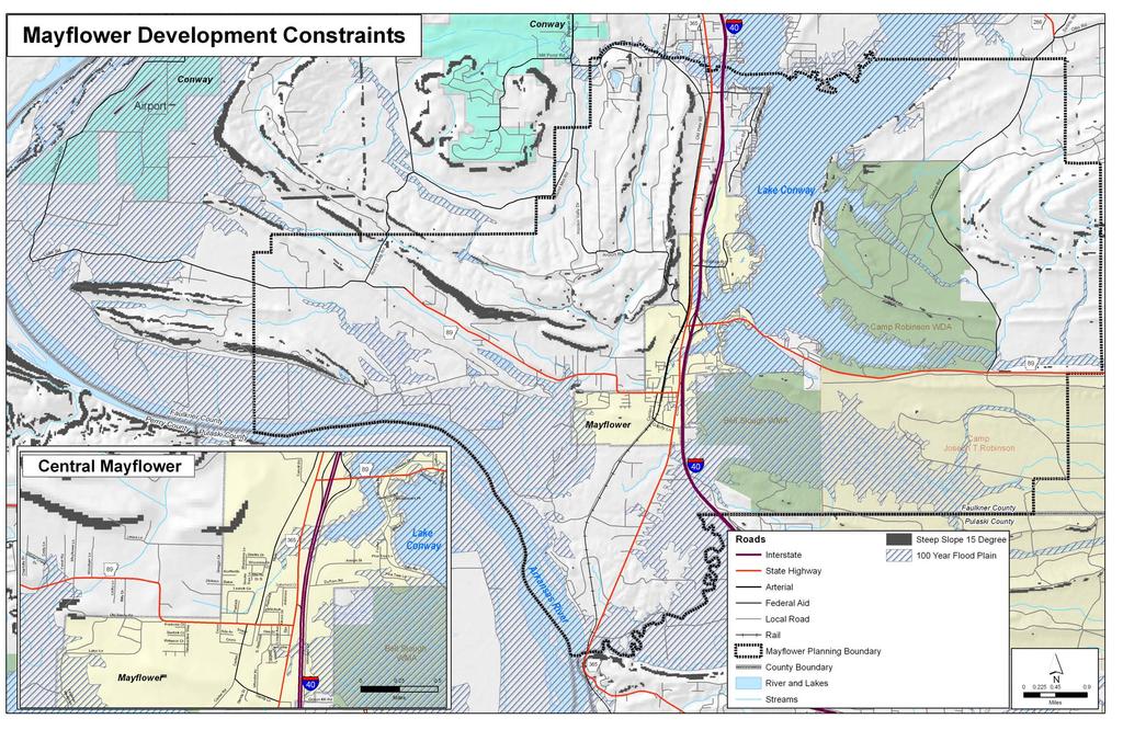
12 Map 2
13
14 continue to shape Mayflower in the future. The pattern of future development is reflected on the plan map. The physical constraints are described below: Flood plains - Flood plains occur principally in conjunction with Lake Conway, Palarm Creek, and the Arkansas River. This land has been identified by the U.S. Army Corps of Engineers as a 100 year flood plain, which critically constrains urban growth. Steep Slopes - The most prominent area of steep terrain lies to the north and west of Mayflower. Round Mountain is the dominant physical feature, but there are numerous ridges that radiate from Round Mountain with steep slope restraints. Several of these ridges fall within Mayflower s planning area. Although a number of upscale homes have been built on the ridges, development potential is typically limited by hillside grades with slope at 25% or greater because of the increased costs for streets, water, sewer, and other utilities. Low density housing can be accommodated, but conservation measures such as private timber management or the maintenance of public open space is preferred for such areas. Transportation Corridor - Between the ridges, the flood plains, and Lake Conway runs Interstate 40, a transportation corridor of national significance. Interstate 40 runs from California to North Carolina, making it one of the major truck routes in the United States. This corridor also contains the Union Pacific Railroad and Arkansas State Highway 365. Each of these north-south routes poses a barrier to east-west travel in Mayflower and influences the pattern of development: Interstate 40 is a controlled access highway with one fully directional interchange with Highway 89. Highway 365 runs north-south, parallel to Interstate 40. The Union Pacific Railroad runs north-south parallel to Interstate 40 and Highway 365, with only two at-grade crossings in Mayflower. One crossing is at Highway 89 and another is at Gandy Lane. Trains periodically cause delay of east-west travel, prompting plans for a rail grade separation. However, current plans slate the project to be completed around As a result of these transportation challenges, the City of Mayflower is divided into three separate development areas. Two areas are east of the transportation corridor and one is on the west side of it. The two areas on the east are separated by an arm of Lake Conway so that there is no direct travel between the two. One of these areas is connected to the central part of Mayflower by Paradise Road and the other by Highway 89. These two routes are the sole means of access. Just as dramatically, the area west of the railroad is limited to two points of access (Highway 89 and Gandy Lane) to the central part of Mayflower. Population The following chart shows the population of Mayflower from 1930 to The population stayed below 500 residents until the 1970 s, a decade in which rapid population growth was experienced throughout Central Arkansas. By 1980, Mayflower had well over 1,000 residents. As of 2010, the town s population had nearly doubled again to 2,234 residents, making it the fourth largest city in Faulkner County. 9
15 As Chart 2 shows, Mayflower population has generally grown at a faster rate than the Faulkner County average, although during the 1980s and 1990s the town grew more slowly. During the decade from 2000 to 2010, the town once again outpaced the county average, growing by 37 percent, compared with 32 percent growth for Faulkner County. Chart 1. Mayflower Population Trend Chart 2. Population Growth Rates by Decade Mayflower vs. Faulkner Co. The Little Rock-North Little Rock Conway MSA, the metropolitan region of which Mayflower is a part, grew faster than the national average during the decade. The region s fastest growth occurred in its outlying counties, of which Faulkner has been the fastest-growing in the past two decades. Situated along Interstate 40 and State Highway 365, about midway between Maumelle in Pulaski County and Conway in Faulkner County, Mayflower benefits from its strategic location along the region s primary northwest-trending growth axis, with population increases reflecting the rapid increases in population of the larger adjacent communities. Conway, about ten miles to the north, has grown into one of the largest cities in Arkansas in recent years. Maumelle, five miles to the south, is the fastest-growing city in Pulaski County. 10
16 Ethnic Composition Mayflower s ethnic breakdown in 2010 is shown in the chart below. Non-Hispanic whites make up about 90 percent of the population. The Black population is about 5 percent. The population classified as other, primarily Asians, is about 2.4 percent, with about 2.4 percent Hispanic/ Latino. As the chart also shows, both Faulkner County and the nearby city of Conway have proportionately larger nonwhite populations. Chart 3. Racial Breakdown Comparison Age Structure In the past, Mayflower s age structure has differed sharply from the regional average. The town traditionally has a higher median age than average, meaning it has a smaller-than-average share of young persons, and a large proportion of elderly and near-elderly populations. Yet there is evidence that while still hosting an older-than-average population, Mayflower is coming to more closely resemble the regional average. Chart 4 shows Mayflower s median age from 1980 to 2010, and compares it with the Faulkner County average. The county, which hosts a large college population, has the lowest median age among counties in the Central Arkansas region. Thus Mayflower has tended to stand out against the county average. Chart 4. Median Age
17 The median age in Mayflower was as high as 46 years of age in 2000, compared with just 31 for Faulkner County. The U.S. average, not shown, was 35.3 in The next three population pyramids show how the population of Mayflower has shifted the past three decades, becoming younger, as displayed by the growing base of the pyramid. The drop in age is in line with Mayflower s developing role as a bedroom community, attracting a higher share of middle-aged homeowners with children, than in the past. Chart 5. Mayflower Population by Age and Sex 1990 A G E Chart 6. Mayflower Population by Age and Sex 2000 A G E 12
18 Chart 7. Mayflower Population by Age and Sex 2010 A G E Housing Table 2 provides basic Mayflower housing statistics for the years 1990 through While typical vacancy rates in the Central Arkansas region run less than 10%, Mayflower has historically experienced much higher vacancy rates (16% in 1990 and 15% in 2000), thought to be due to the high number of seasonally vacant housing units around Lake Conway. From 2000 to 2010, though, the Mayflower vacancy rate decreased to 12%. The decrease in vacancy rates, combined with the changes in the age of Mayflower residents occurring during the same time period, seems to confirm that Mayflower is changing from a semi-rural community with a higher-than-average share of retirees and part-time residents into more of a bedroom community. Table 3 shows that, as with much of the country, the proportion of owneroccupied housing units is down from 2000, but it is still well above the national average of 67%. 2 Table 2. Mayflower Housing Statistics Source: Decennial census Table 3. Owner- versus Renter-Occupied Housing
19 Table 4 gives a profile of Mayflower housing units by type in 1990 and The city s share of one-unit, detached homes was about the same as the Faulkner County average (66 percent vs. 65 percent for the county). Mayflower had few multi-family units in 2000, and no structures with ten or more units. By comparison, about 6 percent of Faulkner County units were in such structures. Where Mayflower really stands out is in the share of mobile homes, at 29 percent of the total in 2000, compared with a county average of about 15 percent. 3 No reliable comparison data are available for Table 5 compares Mayflower housing stock with that of Faulkner County. Mayflower homes are older than the county average, with most being built between 1980 and In Faulkner County as a whole, 53% of the housing stock was built after 1990, while only 40% of the Mayflower area housing was built after Table 4. City of Mayflower Housing Types Table 5. Share of Housing Units by Year Built Population Projections Table 6 gives three alternate population projections Source: ACS for the Mayflower Planning Area, showing different futures. The projections are based on Mayflower s location in the Little Rock-North Little Rock- Conway metropolitan area, and the town s role within that metropolitan area. Table 6. Population Projections The first two projections, Metro 2030-Trend and Metro 2030-Policy, are by-products of the regional long-range transportation planning process, completed in the year So far the trend projection has held up well. For example, the trend projected a total population for the Mayflower Planning Area of 7,947 for the year 2010, while the actual Census 2010 result of 7,561 was very close. The third projection, titled 2030-Alt here, assumes Mayflower continues growing from its 2010 base population at a rate about twice as fast as Faulkner County as a whole. The result
20 is a doubling of population by 2030, to nearly 16,000. While substantially less than the Metro 2030-Policy projection, this alternative assumes that the rate of Mayflower population growth accelerates over the next decade. Economy Commuting Patterns Chart 8. Workplace of Mayflower Residents 2000 Mayflower s primary economic role is as a bedroom community. This means that its economy is based on residents who commute to jobs in nearby communities. As seen in Chart 8, the largest single group of Mayflower residents worked in Pulaski County in the year The second-largest group worked in Faulkner County north of the Mayflower area. Only about 9 percent worked in Mayflower or its immediate proximity. 4 In 2000, there were a total of 682 jobs in the Mayflower area. About 56 percent of these jobs were held by residents of the immediate area. (Chart 9) Thirty percent were held by other Faulkner County residents, while small numbers of workers commuted in from Pulaski County, Perry County, and other areas. Just 6 percent came in from outside the six-county Little Rock-North Little Rock-Conway MSA. Therefore, in relative terms, jobs in Mayflower are not a major draw to residents from outside the area. Since income is the most important single determinant of the distance workers are willing to commute, this suggests the majority of local jobs are comparatively low-paying, as indicated by Table 7, which shows earnings for workers by place of work. Over 38 percent of Mayflower workers earned $1,250 per month or less (under $15,000 a year), compared with below 30 percent for both Faulkner County and the LR-NLR-Conway MSA. Similarly, fewer Mayflower jobs were in the highest earning range of over $3,333 per month (approximately $40,000 per year). Chart 9. Workplace of Mayflower Workers 2000 Table 7. Comparison of Mayflower Earnings with Faulkner County & MSA Source: LEHD, This analysis uses census tracts and (See Appendix A) because they represent the smallest geographic unit for which reliable, current employment and comunity data are available. 15
21 Income of Residents Household income levels of Mayflower residents run below national and Faulkner County averages. For example, the median household income in 2009 was $29,132, compared with $44,600 for Faulkner County and $51,425 for the USA (American Community Survey ). Chart 10 breaks down household income into four categories. Over 25 percent of Mayflower households had a household income between $20,000 and $39,999, according to the American Community Survey Mayflower s share in the $40,000 to $99,999 category was 37 per cent, compared with about 40 percent for national and county averages. Thus, Mayflower had more households in the two lowest categories shown below, and fewer in the top two Chart 10. Share of Households by Income The American Community Survey (ACS) data also suggests that for the period median household income declined 18 percent in nominal dollars, and 34 percent after adjusting for inflation. This decline seems too steep. The Longitudinal Employer-Household Dynamics (LEHD) data set from roughly the same time period shows local earnings rising in nominal dollars through 2009, and rising at a faster rate than state and U.S. averages. While the two data sets are derived through very different methods, the LEHD comes closer to representing a full survey, whereas the ACS involves potentially large sampling error with a community as small as Mayflower. In short, reliable data on income/earnings trends for Mayflower residents since 2000 is lacking, but the balance of evidence suggests the community did no worse than the national average during the recession years Table 8 shows the change in earnings for Mayflower residents from 2003 to On a positive note, Mayflower residents saw a faster decline in the share of Table 8. Change in Number of Local Resident Workers by Earnings Category workers in the lowest earnings category than county and MSA averages, while it saw faster growth in the highest category. Source: LEHD 2003 and
22 Even the LEHD data, however, show Mayflower residents in 2009 still had a smaller share of workers earning in the highest category than county or MSA averages. Income by Age Much of the lower income status in Mayflower may be explained by age. When age is compared with income status, more Mayflower residents in the 55+ age bracket are at the near poverty level or with low to moderate income versus the Little Rock-North Little Rock-Conway Metropolitan Statistical Area and the United States, as illustrated by the following charts. These statistics appear to confirm Mayflower s historic role as a more affordable resort/retirement community. Chart 11. Income by Age (55-64) Chart 12. Income by Age (65+)
23 Education Incomes correlate closely with educational levels. It is not, therefore, surprising that the education levels of Mayflower residents are generally lower than U.S. and Faulkner County averages. As Table 9 shows, Mayflower had a higher share of residents with no high school diploma, and fewer residents who had attained a BA or higher degree, than U.S. or county averages. Mayflower was closest to the national average in residents who had at least some college, meaning residents had either no degree or a two-year degree, but had not attained a BA degree. Students in Mayflower and the surrounding planning area attend either the Mayflower School District or the Conway School District. Table 10 contains key statistics to compare these school districts with others in Faulkner County. Educational performance is an important factor in location decisions by both large companies and individual families. The Conway and Mayflower school districts reflect a wide disparity in critical statistics such as Composite ACT Score and College Remediation Rate. Economic Structure Table 9. Educational Attainment Comparison for Population Age 25+ Source: ACS Table 10. Faulkner County Schools Comparison of Key Statistics for 2010 Source: National Office for Research On Measurement and Evaluation Systems, at: As previously noted, Mayflower is primarily a bedroom community. The number of jobs within the city is comparatively small about 649 according to the most recent (2009) figures available from the Census Bureau s new LEHD dataset. The city has more than twice the regional average of retail sector jobs 175 jobs or 27 percent of all employment, versus 11 percent for the six-county Central Arkansas region. The disproportionately large retail sector is a reflection of the small number of local jobs, however, rather than the presence of a full-range retail sector, as discussed in a later section. Mayflower s second largest sector is educational services, accounting for 105 jobs and 16 percent of employment, compared with 8 percent for the region as a whole. Mayflower s third-largest sector is health care and social assistance, with 9 percent of jobs, or about half the regional 18
24 average in this sector. In manufacturing, Mayflower has an above-average share, with 63 workers, or nearly 10 percent of locally-based jobs. The regional average is 7 percent. The largest manufacturing employer is Blackhawk Molding Company, which employees approximately 100. Blackhawk is a pioneer in supplying plastic injection molded products to the dairy, bottled water and juice industries. The company has developed a full line of caps for the bottled water industry, becoming a dominant supplier. ( history.aspx) Other smaller manufacturers are BW Welding, Green Steel Fabricators, and Jamar Carports & Portable Buildings. (Source: Harris Arkansas Manufacturer s Directory) Chart 13 shows jobs as a share of total employment for Mayflower in comparison with the sixcounty Central Arkansas region. Chart 13. Employment by Industry Data source: U.S. Bureau of the Census, LEHD 19
25 An important measure of a local economy is the size and nature of its export sectors. Jobs in manufacturing, information, and high technology and professional services are usually oriented toward export, while jobs in sectors like retail trade, health, and public administration usually serve local needs. A critical measure is each sector s location quotient. This is a measure of the portion of local jobs in each economic sector compared with the average portion of jobs in a larger area. The table below compares Mayflower with the larger LR-NLR-Conway MSA. Location quotient (LQ) refers to local employment concentration measured against the regional average. For example, the figure of 2.36 in retail trade means Mayflower has 2.36 times as many jobs in this sector as the regional average. Any LQ over 1.0 refers to a larger-than-average share of jobs. Table 11 shows the dominance of retail trade and educational services in Mayflower s economy. Between them, these sectors account for 43 percent of all locally-based jobs. The prominence of both sectors points to how Mayflower serves as a bedroom community, since both sectors serve primarily the local resident population. Other sectors near the top of the list, like utilities, construction and public administration, serve similar needs. The high location quotient of wholesale trade, transportation and warehousing, and manufacturing confirms the small cluster of related sectors probably benefiting from the town s highly accessible location along I-40 and between the fast-growing city of Conway and the multiple cities in Pulaski County. The nearby cities of Conway and Maumelle are also notable for their larger-than-average manufacturing sectors within the region. Table 11. Employment Sectors Ranked by Location Quotient Shift-share analysis compares changes by local economic sector with a larger region. This technique can reveal the rate of growth in each sector with regional growth, and can reveal the possible presence of local factors that might explain faster-than-average growth in a given sector. Shift-share analysis of Mayflower from 2003 to 2009 revealed local competitive advantages in retailing, manufacturing, wholesale trade, transportation/warehousing, and construction. Local growth was especially pronounced in wholesale trade. The shift-share technique must be used with care, because (especially with a small community like Mayflower) simple one-time changes like a major store opening, or a single new small factory, may be random and isolated events that disproportionately impact the statistics. 20
26 Retail Development As part of the Arkansas Community of Excellence (ACE) process, basic retail demographics from Esri were made available for the City of Mayflower through the Arkansas Economic Development Commission. Table 4 shows the retail needs estimated to be unmet by local merchants. Because the needs are unmet locally, these sales and the resulting sales tax revenue are benefiting other communities. On the positive side, the unmet retail needs represent opportunities to establish and grow local businesses. The unmet retail needs can also be used to recruit outside businesses, which will also provide jobs and sales tax revenue to Mayflower. Table 12. Estimated Unmet Retail Needs by Industry Group *Industry Sector Source: Esri, Courtesy of Arkansas Economic Development Commission 21
27 Retail sales from Lumber One, which opened in 2008, do not appear to be included in Esri s analysis, which indicates total leakage in the category of building materials, garden equipment and supply stores. Other than that, the report seems to fairly reflect the few retail sectors present in Mayflower. The chart reveals that Mayflower shoppers spend a great deal of money outside of town, but new retail establishments like Lumber One and Fred s are starting to fill that gap. The types of retail businesses that will want to locate in Mayflower will continue to be limited though. Retail expert Esri uses a variety of data to classify U.S. residential neighborhoods into 65 unique market segments based on socioeconomic and demographic characteristics that retailers use to determine fruitful markets. Esri data demonstrate that the population of Mayflower fits into two market segments labeled Rooted Rural and Southern Satellites. Unless a major shift in demographics occurs, retailers that cater to an older, more rural-based market will be the ones attracted to Mayflower. Preferences of Rooted Rural Rooted Rural residents are do-it-yourselfers. These settled families take pride in their homes and keep busy with home improvement and remodeling projects. They also take pride in their gardens, regularly buying lawn and garden insecticides, flower and vegetable seeds, and plants. Typical of their rural lifestyle, many have a lawn or garden tractor and ATVs and own an assortment of tools. They prefer domestic vehicles; most households own or lease a truck. Typically a household member handles vehicle maintenance. Many homes have pets. When families eat out, they prefer Ryan s Family Steakhouse, but they generally prepare meals at home with fresh vegetables from their gardens. Many homes own a separate freezer to store their produce. They shop for groceries and buy their favorite Folger s coffee at Winn-Dixie, Piggly Wiggly, or a WalMart Supercenter. They hunt, fish, ride horseback, attend country music concerts, and go to car races. They read hunting and fishing magazines and listen to country music and auto racing on the radio. Many have a satellite dish so they can watch rodeo/ bullriding, truck and tractor pulls, reality TV, auto racing, and fishing programs as well as a variety of shows on CMT. Preferences of Southern Satellites These rural residents enjoy country life. Fishing and hunting are two favorite leisure activities, and Southern Satellites residents spend money for magazines, clothes, and gear related to these interests. Because cable is not always available, many residents own satellite dishes. Many own pets. They work in their vegetable gardens and might own equipment such as riding mowers and tillers to help with outdoor chores. Most households have two or more vehicles to meet their transportation needs; they prefer domestic cars, and many drive trucks. They consider themselves to be politically conservative. They read newspapers and magazines infrequently; however, they listen to country radio and watch fishing programs, NASCAR racing, and country music programs on TV. Owning personal computers and going online from home isn t important to these residents. 22
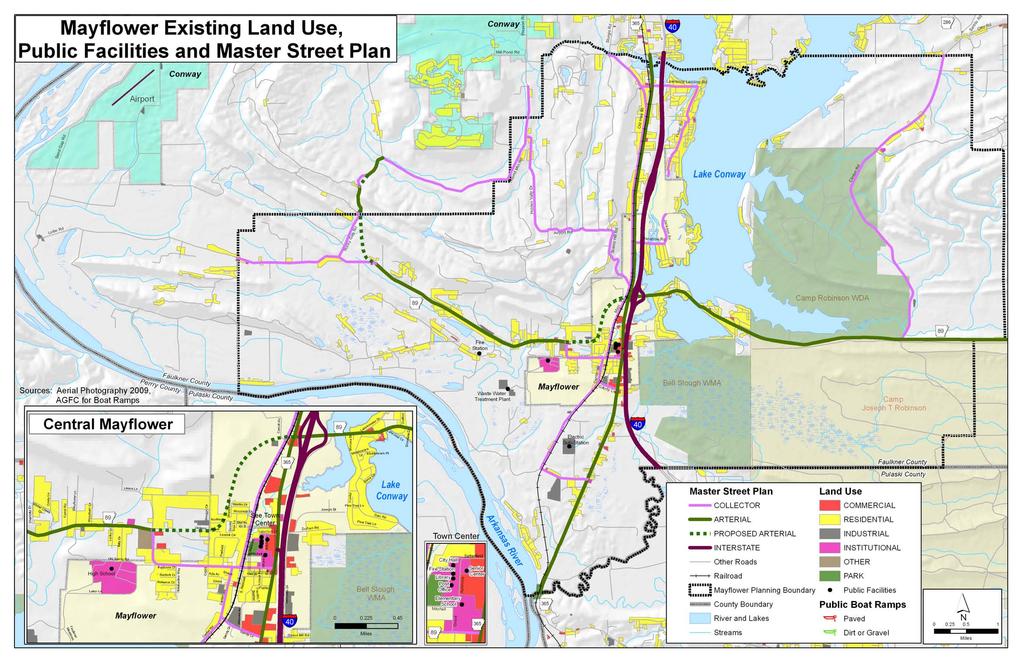
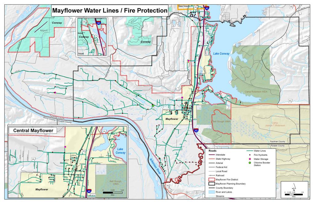
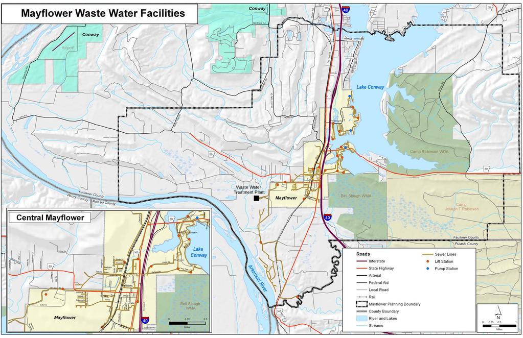
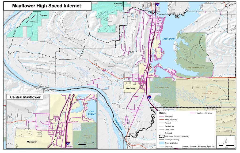
28 Community Services and Facilities (See Map 3, page 25) Utilities Water and Sewer The City of Mayflower provides both water and sewer to residents, as well as providing water to areas outside of town. Mayflower is supplied with up to 500,000 million gallons per day of treated water from Community Water Association, with a flow rate of up to 1500 gallons per minute. Four water towers are located throughout town, including a new one with 600,000 gallons of capacity by Lollie Street. The engineering firm of Mehlberger Brawley, Inc. completed a detailed hydraulic analysis of the City s water supply and distribution system to determine and recommend modifications needed to improve system reliability and performance. As a rural water system, water is provided to a number of areas outside the city limits, including the Plantation Oaks area which is under a pre-annexation agreement south of town. The recently constructed Highway 89 North water extension will serve 250 homes in the Lollie Bottoms area outside the city limits. (See Map 4, page 27) The sewer treatment plant is located by the high school complex, with a capacity of 500,000 gallons. The city currently processes around 160,000 gallons per day. Map 5 (page 29) shows the location of existing lines. Electrical Services are provided through Entergy. Natural Gas Services are provided through Centerpoint Energy. Internet Service Broadband internet services are provided by AT&T (DSL), Alliance Communication of Greenbriar (internet cable), through Dish Network (satellite) and through The Computer Works of Conway (fixed wireless). According to Connect Arkansas, much of Mayflower now has the ability to receive broadband internet. (See Map 6, page 31) The Computer Works recently installed a new tower in the Round Mountain area that will provide service to more of western Mayflower. However, because of the mountain and other obstructions, a site survey must be performed to ensure coverage. Subscription Television Cable services are provided by Alliance Communication (Greenbriar) and satellite though Dish Network. Public Safety Emergency Response The City participates in the Faulkner County Code RED Emergency Alert and Weather Warning to advise citizens of potential life-threatening situations. In case of medical emergencies, the Mayflower Fire Department performs the initial assessment and provides first aid until a Metropolitan Emergency Management Services (MEMS) ambulance is able to reach the scene. Emergency dispatch is provided through the county. Fire The Mayflower Fire Department is a rural fire department staffed by 17 volunteers. Chief Carl Rossini is the first full-time paid fire chief for the Mayflower Fire Department, also serving as the head of code enforcement. Mutual and/or automatic aid agreements exist with surrounding fire departments. The current ISO rating is 7/9, but this should improve now that the new three 23
29 bay substation has been built on Easterwood Point Road. Emergency services to the west side of town will no longer be limited periodically by trains. Because the rural fire department serves an area of about 35 square miles around Mayflower (See Map 4, page27), the property tax assessment of $35 per household is reportedly adequate to provide needed equipment. Existing equipment includes: 2 pumper trucks 2 rescue trucks, 1 with foam to put out car fires 2 tanker trucks with a Cascade pump system Extrication tools Medical truck with supplies Fire flow is adequate for current needs. Chief Rossini is working to set up dry well systems around the lake and outside the city in areas with ponds so that the area to which the Fire Department can respond can be increased. If the City grows to the point that two-story buildings are constructed, the Fire Department will need to acquire a ladder truck. Police The Mayflower Police Department currently has six full-time and six part-time officers, with seven cars. Chief Billy Paul Baker believes that with the current level of population growth, two additional officers will be required in the next five to ten years. The Police Department is housed in a small building near City Hall; Faulkner County Unit 2 is used for jail facilities. The Arkansas Wireless Information Network System (AWINS) is used for local communication, also providing interoperable communication with public safety and emergency officials around the state. The Police Department also provides animal control for the City with one part-time animal control officer. Parks, Recreation and Open Space As shown in Map 1 (page 5), Mayflower is blessed with an abundance of open space and outdoor recreational activities by virtue of its proximity to Lake Conway, the Camp Robinson Wildlife Demonstration Area, Bell Slough, detailed below: Lake Conway is an excellent fishing lake, stocked with bass, catfish, bream and crappie. Several free public launch areas are maintained by the Arkansas Game & Fish Commission; boat rentals are available at several commercial docks on the lake. Adams, Brannon s, Bream s Nest, Gold Creek, Highway, Lawrence, Martin s Northshore, Palarm Creek, Paradise, Pierce Creek and Sevier s are the landings with boat ramps. ( Bell Slough Wildlife Management Area is a 2,040-acre tract of land south of Mayflower. In addition to waterfowl hunting, this management area offers a 2.25-mile interpretive trail that meanders through various habitat types including a wetland and a forest. (www. stateparks.com) Camp Robinson Wildlife Demonstration Area covers almost 30,000 acres and offers a shooting range that includes an archery range, a rifle/pistol shooting range with trap and 24
30 Map 3
31
32 Map 4
33
34 Map 5
35
36 Map 6
37
38 skeet facilities, a dog field trial and training area, and hunting for small game and deer. Hiking, birdwatching and trail riding can also be enjoyed here. Primitive campsites are available. ( However, other recreational opportunities such as ball fields and playgrounds are not as abundant. City parks include: Franklin S. Pearce Memorial Park is located by City Hall, with a small baseball field and a pavilion, and playground equipment. The Railroad Recreational Trail will begin at Pearce Park and travel to the Big Star Shopping Center. Future plans call for extending the Railroad Recreational Trail south from Big Star to loop back to Pearce Park. Palarm Creek Park The City of Mayflower has a 99 year lease with the U.S. Army Corps of Engineers to use this area outside the city limits as a park. The city is working to clean up the park and provide picnic tables, playground equipment and parking for day activities. Long range plans include tying this area to the Arkansas River Trail, a combination bicycle/ pedestrian trail originating in Little Rock and North Little Rock with an eventual terminus in Conway. Additional plans for Palarm Creek park include construction of a tournament capacity boat ramp on the Arkansas River with a handicap accessible fishing pier. The City of Mayflower has no formal Parks Department; maintenance for existing parks is provided by the street department. In order to become more of a draw for both residential and commercial users, additional recreational opportunities should be created. The National Recreation and Parks Association (NRPA) has developed guidelines for park needs, with a general rule of thumb that 6.25 to 10.5 acres of developed open space per 1,000 population should be set aside. 5 Parks can take several forms: Mini-Park A mini park is five acres of land or less, intended to attract residents living within a quarter mile of the park. Because it is intended for people who live close by, parking may not be included with the park, but a mini-park will have benches, walking paths, attractive landscaping, playground equipment, etc. Neighborhood Park A neighborhood park is 5-20 acres, with a service area of one half-mile. Parking is required. Facilities could include ballfields, playground equipment, pavilions and restrooms. School Playgrounds/Ball Field sites are a good way to combine resources and provide recreational amenities for the community if the school district is willing. Community Park A community park serves multiple neighborhoods, offering both active and passive activities. This type of park usually covers acres. Such a park might include athletic fields and playgrounds, as well as walking trails and large natural areas, and often aquatic facilities. Parking and restrooms would be provided, and the facility would be planned for nighttime use. Including school facilities, acres are devoted to recreation space in Mayflower. Thus, the existing recreation facilities in the Mayflower city limits are adequate for current needs (if the school facilities are included), but space should be identified and set aside to meet the demand for 5 Information on NRPA standards excerpted from 2000 Hot Springs Comprehensive Parks, Recreation, and Open Space Master Plan and 2010 Fayetteville, Arkansas Comprehensive Parks and Recreation Master Plan. 33
39 parks as Mayflower grows. If the City of Mayflower wants to rely on the Mayflower School District to help meet the demand for recreational facilities, formal discussions should be conducted between the two on how best to make this partnership work in the future. Table 13. Park and Recreation Facility Development Standards For Mayflower Planning Area 34
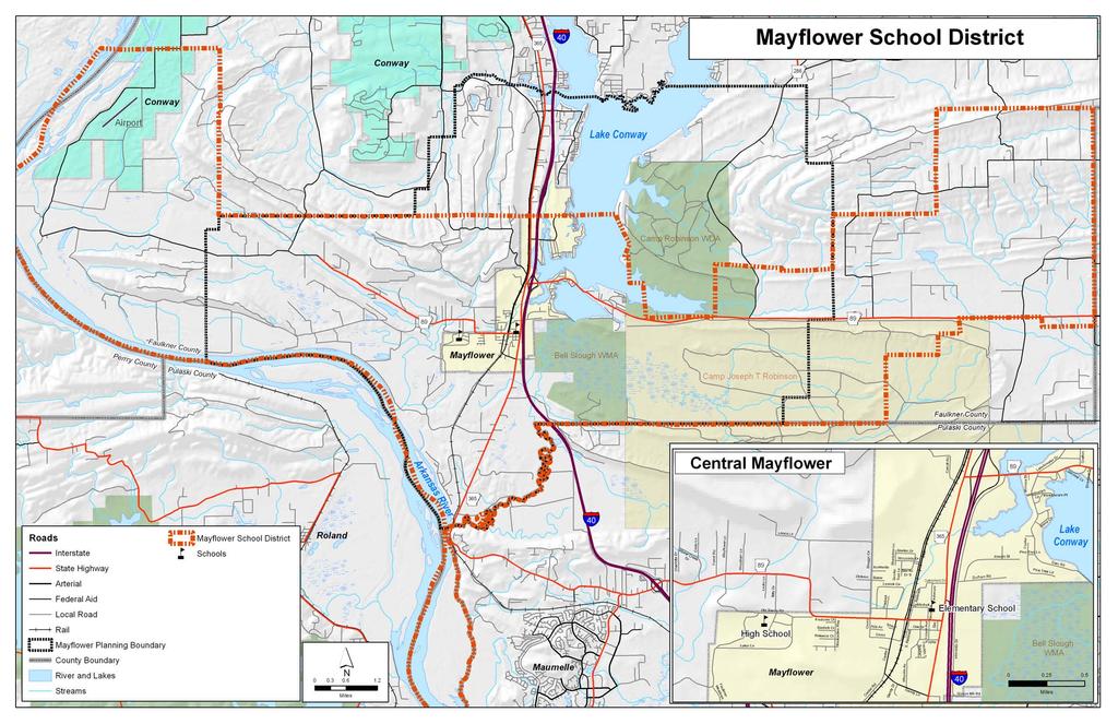
40 Medical Services The City of Mayflower has a small medical clinic operated under the umbrella of Conway Regional Hospital. The Mayflower Medical Center currently has a staff of seven, including two physicians, one nurse practitioner, two nurses and two office workers. A pharmacy is located in the Big Star Grocery, while a dental practice, medical equipment office, and a physical therapy practice are located in the same shopping center. A veterinary medicine clinic is located further south on Highway 365. An additional pharmacy was added when the Fred s retail store opened in late History and Culture Library The Faulkner-Van Buren Regional Library system operates a branch in Mayflower, located at #6 Ashmore Street. The library is open from 12:00-6:00 p.m. Monday through Friday. Social Services Boys and Girls Club The Boys and Girls Club of Faulkner County operates an afterschool program inside the Mayflower Elementary School gym. Senior Citizens The Faulkner County Senior Citizens Center operates a facility located across from Mayflower City Hall. Programming is provided three days a week, and Meals on Wheels delivers food to senior citizens in need of this service. Civic Resources Mayflower Chamber of Commerce is a voluntary business association of area firms and concerned individuals who work together to achieve a favorable business climate, while enhancing the quality of life for community residents. Sanitation Solid Waste The City has a contract with DC Trash to provide trash pickup one time per week for city residents. Bulk trash pickup is provided on a quarterly basis. Recycling Curbside rycycling is provided citywide by DC on the third Friday of each month. Also, two recycling trailers from the Faulkner County Regional Landfill are placed in front of City Hall for collections. Schools Although students from Mayflower and the Mayflower Planning Area Boundary may attend either the Mayflower School District or Conway School District (See Map 7, page 37)), only the Mayflower School District, with a total enrollment of 1,024 students, has facilities inside the city limits. No institutions of higher education are present in the city, but the University of Arkansas at Little Rock, Pulaski Tech, the University of Central Arkansas, Philander Smith, Hendrix College, and Central Baptist College are all within a thirty minute drive. 35
41 The Mayflower Elementary School is located near Mayflower City Hall on Grove Drive. The current facility has a life of at least fifty years and can accommodate up to 100 more students. A growing preschool program may require the addition of a new building on that site at some point. A tornado shelter will be built at this facility as funding permits. The upper grades are housed on the main campus at #15 Old Sandy Road. A twenty year plan has been developed for the campus by Jackson Brown King Architects. Plans are to add on to the middle school soon. The athletic fields will be renovated in three years. A new high school is expected to be required in twelve years, at which time the current high school will become the junior high. With only one way in and out of the campus, providing a second means of access for traffic flow, but also for emergency situations, will be critical. 36
42 Map 7
43
44 DESCRIPTION OF MAYFLOWER ISSUES 6 A Small Town Atmosphere With Big City Access The motto of the Mayflower Chamber of Commerce sums up Mayflower s biggest asset it possesses a close-knit, small town atmosphere while being in close physical proximity to larger cities and the amenities they provide. Mayflower residents especially like the small size and many are reluctant to see it grow, yet the town s strategic position along the Interstate 40 transportation corridor between fast-growing Conway and the Little Rock-North Little Rock area makes it highly likely that the population of Mayflower will increase dramatically in the next years. The question is how best to manage this growth? In addition to the small town feel, Mayflower residents like Lake Conway and the outdoor recreational opportunities it affords. The schools are perceived as good, crime rates are very low, and there is a great spirit of community service and volunteerism. But Mayflower does have problems. For one thing, much of the land inside the Mayflower city limits is not developable, so that growth in the Mayflower area will not necessarily translate into residential growth in the city and a corresponding increase in financial resources to pay for city functions. The fact that Mayflower s water is provided through a rural water system means that one of the usual carrots to encourage annexation into a city is unavailable. Provision of wastewater treatment services is another carrot typically used to encourage annexation, but the drop in new housing starts due to the recession of makes this route to population growth inside the city limits unlikely for several years. Mayflower has no downtown and the area currently considered to be the town center has access issues and is un-walkable. Both the train tracks and the lake isolate various parts of town, somewhat inhibiting the sense of community. In order to attract new businesses to Mayflower, water lines need to be upsized in many areas, and sewer lines need to be extended, particularly to the critical undeveloped real estate on Interstate Drive. Much of the existing housing stock is old, and many of the homes around Lake Conway are prone to flooding. It is difficult for younger workers, like teachers, to find appropriate affordable housing often they are forced to live out of town. There is also no group senior housing, so that it will be increasingly difficult for older residents to live in Mayflower when they can no longer drive or need more care. The lack of developable land, and water and sewer lines in key areas is also problematic for commercial development of all kinds. Additionally, it is difficult to compete with the low utility rates provided by Conway Corporation. The trade-off between cheaper land versus cheaper utility rates creates a challenging issue for Mayflower s developers. And although broadband internet is becoming more widespread, some locations may still lack access. One of the biggest assets of Mayflower, Lake Conway, has its own problems with filling-in, flooding, and poor water quality. Most of the homes on the lake are on septic tanks, and 6 Information from this section comes from interviews with Mayflower officials, kick-off meeting on April 25, 2011, and subsequent public meetings. 39
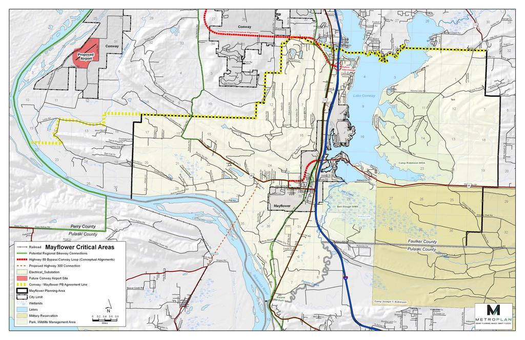
45 extending sewer beyond Phase 1 of planned services through the Faulkner County Public Facilities Board is cost prohibitive for the mostly low-income homeowners around the lake, even with increasingly scarce grant funding. Many feel the Arkansas Game and Fish Commission has not taken adequate care of Lake Conway and has failed to properly promote the lake. Two of the biggest opportunities for Mayflower are spilling over from the City of Conway. The new Interstate 40/Conway Loop interchange is being planned as an attractive gateway to the Meadows Technology Park in Conway, home of the $28 million Hewlett-Packard Services Center and other technology-based businesses. Employees from new companies recruited to the interchange area may choose to live in Mayflower, particularly in situations where one spouse works in Little Rock or Maumelle. A second opportunity comes from the new Conway airport. Although it is planned as a general aviation facility, the opportunity for future expansion in other economic directions exists. A future new railroad overpass through Mayflower has prompted many discussions of a new road to the airport, with possibilities for development in this area. Map 8 shows areas thought to be critical to Mayflower s future. Another opportunity comes from Mayflower s situation along Interstate 40, the railroad, and Highway 365 between Little Rock and Conway. When rail transit happens along this corridor, Mayflower will be a prime location for a station. Identifying the appropriate location for the station and developing around it appropriately will be important. Making this area walkable will be key, fulfilling the desire of Mayflower residents for a more walkable Mayflower, regardless of transit. Mayflower residents are big on recycling and some green activities are planned, such as developing a solar array that can generate electricity to power the wastewater treatment plant, and converting city vehicles so that they can use compressed natural gas. Long-distance bicyclists regularly travel through Mayflower on Highway 365; plans are being developed to attract additional bicyclists by accommodating them more safely on a trail from Palarm Creek that ultimately links up with the Arkansas River Trail. Mayflower residents would like better promotion of existing recreational opportunities and to see more parks and recreation opportunities developed. Better facilities for baseball and softball, for example, would benefit local youth, while attracting tournaments and the resulting sales tax revenue from out of town visitors. A hotel in Mayflower would help in capturing those tourism dollars. The common thread among all the issues and opportunities discussed by Mayflower residents is the lack of funds to help jumpstart their plans. With a property tax of four mills and a two cent sales tax, Mayflower s residents are already taxed more than most other Faulkner County communities. City leaders want to work with existing revenue streams, using changes in public policy identified through this comprehensive plan process as the primary means to create a brighter future for Mayflower. With all these considerations in mind, the goals and objectives discussed in the next section were developed. 40
46 Map 8
47
48 GOALS AND STRATEGIES The following goals and strategies are adopted with this comprehensive plan. These goals and strategies are intended to guide development through the land use plan, and to complement those policies of the master street plan. Goal 1 Protect and preserve the rural character of Mayflower. Encourage attractive landscaping and community wide cleanups. Goal 2 Manage growth in way that maintains the city s small town atmosphere and encourages livability. Encourage the development of attractive and well-built affordable housing. Encourage land uses that strengthen neighborhood identity by creating or preserving attractive and unique built environments and public places. Coordinate the provision of municipal utilities and services, in particular water and sewer, to facilitate moderate density development. Adopt policies regarding the extension of water and sewer services to encourage annexation into the city. Encourage efficient development patterns that reduce the public cost of extending utilities and providing services. Promote and encourage infill development. Provide internal connectivity in the city through a logical street pattern that is agreeable to both motorized vehicles and pedestrians. Encourage sidewalk and trail development. Discourage strip development along Highway 365 by strengthening the overlay district to require rear parking, shared access, and otherwise managing access. Encourage the development of group and senior living centers in pedestrian-friendly mixed-use areas. Goal 3 Create an atmosphere that is conducive to an economic vitality that enhances and sustains the bedroom community character of Mayflower. Create a favorable first impression of Mayflower from the highway. Continue to implement the Arkansas Community of Excellence strategic plan. Revitalize Town Center and adjacent neighborhoods through streetscape improvements and other public actions to encourage private investment. Encourage development of a built environment that is visually attractive and incorporates high quality construction standards. Encourage the development of pedestrian-friendly mixed-use areas that include higher density housing. Develop Town Center as a pedestrian-friendly mixed-use area that includes higher density housing. 43
49 Develop Interchange West as a transit and pedestrian-friendly mixed- use area that includes higher density housing. Goal 4 Develop and promote Lake Conway and other Mayflower area natural resources. Develop partnerships with the Arkansas Game and Fish Commission and Arkansas Parks and Tourism. Develop a master plan for parks, recreation and open space that promotes and encourages a physically fit, healthy, and attractive community. Require set aside of land for parks/contributions to park fund in proportion to the size of the development. Goal 5 Expand, improve and diversify the local economic base and the availability of goods and services. Goal 6 Improve water and sewer service along Interstate Drive to encourage medium size retailers. Cooperate with neighboring communities to develop complementary economic development activities and to promote business investment in the general area. Encourage provision of broadband internet services to the entire City of Mayflower. Utilize outside resources wherever possible to fund new projects. Goal 7 Provide a multi-modal transportation system that is safe, efficient, convenient, and supportive of desired development patterns. Update the master street plan as needed to meet the mobility needs of area residents, workers and visitors. Encourage neighborhood and facility designs that support a range of transportation choices and are visually attractive. Encourage local street, pedestrian and bikeway connections between neighborhoods in order to reduce congestion on arterial roadways and enhance safety for non-motorized modes of transportation. Require construction and rehabilitation of accessible pedestrian facilities in Town Center and other areas where needed, such as in the vicinity of schools, public parks, medical facilities, bus stop, churches, etc. Encourage the creation of bikeways, both on and off road. Encourage the linking of public parks, schools, neighborhoods, commercial areas and other destinations with a network of multi-use trails for pedestrians and bicyclists. Require developers to dedicate sufficient rights-of-way and easements along existing roadways for the planned roadway cross-sections, sidewalks and other facilities. Encourage dedication of land for public use in concert with the community facilities, street and recreation plans. 44
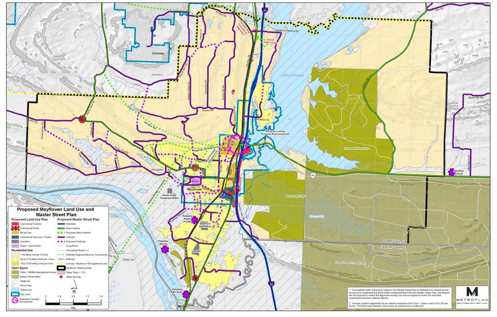
50 LAND USE PLAN Current Land Use Categories At the present time, Mayflower is primarily a residential community, with mostly single-family dwellings. Most of the commercial development is located on Highway 365, with two major areas that could be considered public around the City Hall and at the Mayflower School Complex to the west. Large areas of the planning area are undeveloped and will most likely remain so because they are state property, because they are in the flood plain, or because of the steep ridges that make the land more expensive to develop. Within the Mayflower Planning Area, the following generalized land uses are observed, as illustrated in Map 3: Residential Land that has been developed or subdivided in order to accommodate families or individuals with housing structures, whether built or vacant at this time. Commercial Land used for retail or wholesale trade, professional services, commercial recreation, and private office buildings. Industrial Land used for production, manufacturing, distribution or fabrication activities. Railroad ROW is included because of the fundamental tie with industry. Public/Semi-public Land owned by a public/government agency or otherwise offered for appropriate public activity, including schools, streets, parks, and uses of a public nature such as clubs, hospitals, churches and cemeteries. Vacant Land that is not given over to any urban use even though it may be potentially available for development. Agricultural land in the city is considered vacant land, as are open bodies of water and undeveloped flood plains. Future Land Use Categories Map 9 illustrates proposed future land uses in the Mayflower area with some new categories. Areas thought to be appropriate for residential use, along with conceptual parks and road infrastructure to support them, have been added to this map, bringing the population close to the 2030 projection of 15,979 in the planning area. Two areas have been denoted as Mixed-Use: the area identified as Town Center by the Walkable Mayflower plan in 2008, and an additional area ( Interchange West ) that will be ripe for pedestrian-friendly development once the new railroad overpass is completed. Residential land use has been divided into three categories to allow for traditional subdivisions, as well as more concentrated and multi-family developments. A lower density residential category has been included to illustrate the type of development that will occur in the more isolated areas where sewer is unlikely to be provided. 45
51 Industrial has been replaced in some cases with a category known as Commercial Services/Trades, to better describe the existing land use as well as the stated preference of city leaders for more of the same, rather than traditional industrial. A Commercial Node category has been added to include mostly retail land uses located at key intersections or adjacent to arterial roadways. The Commercial Corridor category will include many of the auto-centric uses currently observed along Highway 365. In order to prevent this area from becoming stripped out as is typical in most towns, it will be necessary to strengthen the existing overlay district to manage access to businesses, add more landscaping requirements, and require parking in the rear of buildings. Because much of the land in Mayflower is undevelopable or development is not desirable because of the extra costs, several subcategories of Open Space have been identified to help distinguish the uses. Future land uses are described as follows: Open Space includes areas that are not developable or are developable only with additional regulations/costs. Wetlands includes areas protected from development by federal government regulations. Flood Plain includes 100 year flood plains areas designated by the 1998 FEMA flood plain map. Agricultural uses are generally appropriate in flood plains, and some public use facilities such as trails, soccer fields, are appropriate. Residential and commercial uses are only appropriate when sufficient measures have been taken to reduce flooding and prevent harm to surrounding properties. Military Reservation includes Camp Robinson and other military installations. Waterways includes Lake Conway, the Arkansas River, Palarm Creek and other bodies of water. Park/Wildlife Management Area includes municipal and state parks, golf courses, walking trails, game refuges, and hunting areas. Residential includes the full range of residential uses, including group living, manufactured housing, and multi-family. 1 Dwelling Per 5 Acres includes rural and suburban areas where municipal wastewater collection is not available or planned, so that large lot development is required for septic systems. Up to 6 Dwellings Per 1 Acre includes both older and newer single family residential subdivisions where the provision of municipal wastewater collection allows the average residential lot to be less than one-half acre per housing unit. 46
52 14-24 Dwellings Per 1 Acre includes smaller single family residential, duplexes, townhomes, garden apartments, condominiums, group homes, senior living facilities, and nursing homes, built where municipal wastewater service and fire protection are available. Mixed Use includes both residential uses, office and appropriate commercial uses as defined by the zoning ordinance. Commercial includes a variety of commercial uses. Commercial Corridor includes a variety of commercial uses designed primarily for automobile access along specified arterial roadways. Commercial Services/Trades includes a variety of office, warehousing activities, and service/trade businesses, as well as light manufacturing. Commercial Node includes mostly retail land uses located at key arterial intersections or adjacent to arterial roadways, typified by gas station/convenience stores and other neighborhood shopping. Industrial Includes existing industrial uses. Public/Semi-public Land owned by a public/government agency or otherwise offered for appropriate public activity, including schools, streets, and uses of a public nature such as clubs, hospitals, churches and cemeteries. 47
53
54 Map 9
55
56 MASTER STREET PLAN Accessibility by motor vehicle is an important determinant of land use. Conversely, land development decision by the public and private sectors also affect the nature of the development of the street and roadway network. Coordination between decisions that affect land use, and streets and roadways, is essential to the development of an area. To this end, the following goals were developed for Mayflower during the previous comprehensive plan process: To improve the ease of east-west vehicle travel in Mayflower by overcoming railroad and highway barriers that restrict east-west travel. To improve the appearance of the city by developing a gateway entry at I-40 and Highway 89, with an emphasis on the improvement of landscape and building design. To develop an access management plan and parking lot standards which promote safety, convenience, and aesthetics along with utility and economy. The Master Street Plan adopted by Ordinance , added some new goals, as well as a number of policies intended to help implement these goals. The following information comes from the Master Street Plan. Goals and Policies from Mayflower Master Street Plan It is the goal of the City of Mayflower to construct streets with emphasis on the quality of travel an arterial provides rather than the number of vehicles per day a roadway can accommodate. Alternative modes of travel such as pedestrian movement, bicycle travel, and transit usage will be encouraged as a means to reduce the number of required vehicle trips per day and the current level of auto dependency. Level of service will be considered, but not at the expense of pedestrian movement and safety. The community transportation network should be fashioned so that residents can travel safely by a variety of means. For many in the community, walking or biking is a primary mode of transportation. The elderly many times prefer to walk, because they do not feel comfortable driving or are unable to drive due to health limitations. Young people, not yet old enough to drive, walk or ride their bikes from place to place even if sidewalks are not provided. People walk and exercise, because it is healthy and enjoyable. Residents should feel that it is equally convenient to walk, jog, or ride a bike as it is to drive short distances. In the interest of promoting modes of transportation other than the automobile, the City of Mayflower has a goal to place more emphasis on non-motorized forms of transportation. By developing facilities for pedestrian and recreational use, the city intends to transform roadways into a public domain used equally by automobiles and non-motorized forms of transportation. Residential and commercial developments will be constructed in a manner which encourages safe, convenient pedestrian mobility. Parking is a necessity which can have positive or negative effects on the appearance of a community. From its inception, the location and character of parking areas should be considered in the planning of a development. Surface parking should be attractive, convenient, and thus 51
57 more inviting, for potential users. The City of Mayflower has developed a goal to discourage the development of parking lots which lack landscaping, are too large for the development they are serving, have unpaved or unmarked surfaces, and are poorly located. Policy: It is the policy of the City of Mayflower to adopt standards for arterial streets that create a boulevard setting with a park-like median with landscaping and to eliminate standards for continuous left turn lanes on arterials. Policy: It is the policy of the City of Mayflower to require sidewalks on both sides of all arterials with wide planting strips between the curb and the sidewalk. Policy: It is the policy of the City of Mayflower to require the development of new streets in a grid or modified grid network and to encourage the construction of new two-lane roads connecting arterials. Policy: It is the policy of the City of Mayflower to require pedestrian scale lighting on all streets and to coordinate the height of signage with tree and lighting heights. The appropriateness of signage shall be determined by the land use and/ or neighborhood. Policy: It is the policy of the City of Mayflower to allow the construction of alleys behind houses and to encourage the placement of utilities behind structures and underground. Policy: It is the policy of the City of Mayflower to discourage the construction of cul-de-sacs in new developments and to allow them only when physical constraints make them the only alternative. Policy: It is the policy of the City of Mayflower to encourage the construction of neighborhood arterials with visual termination points, such as public buildings, parks, or churches in the T-intersections of the modified grid network. Neighborhood centers will be organized around green or common open space and will have multiple points of street access. Policy: It is the policy of the City of Mayflower to require all buildings to front on public streets. Policy: It is the policy of the City of Mayflower to avoid development along collector or arterial streets that results in strip development with each enterprise served by individual driveway access to the street. Policy: It is the policy of the City of Mayflower to promote a transit route between Mayflower and Conway, when the City of Conway begins internal transit service. Policy: It is the policy of the City of Mayflower to prohibit the construction of fences, walls, and other barriers which prevent easy and inviting walking, cycling, or other similar recreation activities. Policy: It is the policy of the City of Mayflower to construct sidewalks and bicycle paths in a comprehensive network which is both complementary and supplemental to the roadway network. Policy: It is the policy of the City of Mayflower to encourage the connection of pedestrian and bicycle routes between new and existing developments. 52
58 Policy: It is the policy of the City of Mayflower to adopt design criteria for pedestrian and bicycle routes along major arterials including landscaping and lighting standards. Policy: It is the policy of the City of Mayflower to allow rear yard parking and on-street parking on specified streets in residential areas and neighborhood centers. Policy: It is the policy of the City of Mayflower to require landscaping in parking lots. Policy: It is the policy of the City of Mayflower to contain the size of lots and establish a minimum number for handicapped parking spaces required on a single surface parking lot. Policy: It is the policy of the City of Mayflower to require that parking lots be placed in the rear and to the side of commercial or industrial developments whenever possible. Parking lots which are placed in front of structures should be separated from roadways by planting landscaping screens, constructing earthen berms, or providing combinations of the two between streets and the parking spaces. Policy: It is the policy of the City of Mayflower to provide a safe, secure parking lot for those wishing to car pool to work in Conway and Little Rock, thus reducing the number of automobiles on the roadways. Functional Classification According to A.C.A , roads are classified according to the level of service they are intended to provide: Class Number I II III IV V VI Rural Systems Interstate Freeways Other Principal Arterial Minor Arterial Highways Major Collector Roads Minor Collector Roads Local Roads Table 14. Arkansas Functional Classification System Municipal Systems Interstate Freeways Other Freeways and Expressways Other Principal Arterials Minor Arterial Streets Collector Streets Local Streets Level of Service Provide basic interstate service, link major cities. Provide high level of interstate and intrastate service, connect Major generators of internal city traffic. Serve trans state travel to and through principal cities. Provide a system for the major traffic generators within a city. Provide connections to and through the large centers of population within the state. Provide inter county service. Serve the economic and state park areas not serviced by a higher system; collect and distribute traffic to and from major streets; provide intra county service to and into population centers and other recreational and industrial areas. Serve small rural communities. Provide access to residential areas, subdivisions and neighborhoods within cities; provide direct access to adjacent properties in rural areas and with cities. 53
59 The right-of-way requirements below guide how developers of private property are involved when their developments impact existing and future routes as classified by function on the Master Street Plan. Right-of-Way Requirement Modification 1. Generally the developer of private property will not be required to furnish additional rightof-way or paving width, beyond plan requirements, when the development proposal impacts highways that are in either the Federal or State system. When the development will cause impact on city and county streets and roads, even though the streets and roads may be Principal or Minor Arterial Streets or Collector Streets, the developer will be required to participate in the improvement of such streets and roads. The extent of participation in the improvement depends upon the amount of improvement needed to bring the street in question up to the standard call for in this, the Mayflower Master Street Plan. The city may assist in the negotiation of an agreement between a current developer and any additional even future, developers to create equity in improvement costs. 2. Proposed streets, subject to the Mayflower Control of Development and Subdivision of Land Regulations, that would extend existing streets, shall be constructed, in terms of right-of-way and paving width, at the same or greater width, of the existing facility, but in no case less than the minimum width as indicated on the table below. 3. The instigator of the development of land that adjoins and gains access from a substandard existing street or streets shall dedicate additional right-of-way and paving commensurate to functional class in order to bring such street or streets up to standards. Such other improvements as curb and gutter, sidewalks, street lighting, landscaping, etc. shall also be provided for along the affected street segments. Table 15. Summary of Right-of-Way and Design Standards Class I & II 1 Class III Class IV Class V Class VI Class VI Right of Way (min.) Paved Width 3 Centerline Grade (max.) 3 9% 9% 12% 15 16% 15% Sight Distance (min.) Radius of Curve (min.) Arkansas Highway and Transportation Department Standards 2. Class III intersection approaches will require an extra width of 20 extending 250 from the centerline of intersecting arterials and collectors. Class IV intersection approaches may require an extra width of 10 extending 150 from the centerline of intersecting arterials and collectors. 3. Centerline grades may be increased subject to the approval of the City Engineer. 4. Includes 10 utility and road work easement, 5 on each side of road. 54
60 The Forms of Streets and Block Creation 1. The basic pattern of existing and proposed Collectors is shown on the Mayflower Master Street Plan. The developers of land traversed by these existing and proposed Class V streets will be responsible for their improvement and initial construction. Additionally, the Class V streets are the framework and provide the connection for Class VI streets. The system of Class V streets are laid out on the Mayflower Master Street Plan to form a large scale grid system by following, wherever practical, the half or quarter section lines of the United States System of Land Survey. 2. The proposed Class VI streets are not shown on the Mayflower Master Street Plan because where they are ultimately constructed is left to the discretion of the developer of private land but using the principles and policies of this plan. These Class VI streets are the most important ones in the hierarchy of streets in the provision of direct service to the abutting property. 3. The Class VI streets shall form a network within the grid of Class V streets. Cul-de-sacs are discouraged. The interconnecting, less wide, Class VI streets shall be laid out in a grid or modified grid in order to appropriately distribute the flow of traffic, i.e., increase the choices of routes thereby improving the level of service on any given street. The Class VI streets will be design to accommodate two way service on two lane streets with on-street parking. 4. The network of Class VI streets requires that every street connect to at least two other streets. Cul-de-sacs shall be restricted as a street design choice. The Cul-de-sac shall only be used when a physical structure (natural topographical or man-made structure) constrains the connection of that one street to at least two other streets. Note regarding the Master Street Plan Map 1. Conceptual roads have been added to the Master Street Plan to illustrate how streets should be placed to implement the goals of the Comprehensive Plan and Master Street Plan. Developers are not required to match the alignment exactly, but will be required to make the indicated connections between collector streets. 2. Several possible alignments for an arterial connection from Town Center west to Hwy 89 are shown. The final route selected will become an arterial once constructed. 55
61 REFERENCES

62 Appendix A Mayflower, Arkansas Comprehensive Plan 57
Moorhead, Minnesota. Photo Credit: FEMA, Evaluating Losses Avoided Through Acquisition: Moorhead, MN
 Moorhead, Minnesota Photo Credit: FEMA, 2010. Evaluating Losses Avoided Through Acquisition: Moorhead, MN Background Moorhead is a midsize city (pop. 38,065) in Clay County, Minnesota. The largest city
2014 Albany Residents Community Survey
 Q1 If you do not live in the city of Albany, we appreciate your interest but ask that you not fill out this survey. This particular survey, much like other citizen surveys conducted nationally, is specifically
Report to the Raleigh Parks, Recreation and Greenway Advisory Board: Off-leash Dog Areas. Background
 1 Report to the Raleigh Parks, Recreation and Greenway Advisory Board: Off-leash Dog Areas Report by Ad Hoc Committee: Jan Kirschbaum, Wayne Marshall, Gail Till, Bill Hornsby (P.U.P) January 20, 2005 Background
Dog Off Leash Strategy
 STRATHCONA COUNTY Dog Off Leash Strategy Phase 2 Report: Consultation Summary December 03, 2014 ENCLOSURE 4 STRATHCONA COUNTY Dog Off Leash Strategy Phase 2 Report: Consultation Summary ENCLOSURE 4 Table
Parley s Historic Nature Park Management Plan
 Parley s Historic Nature Park Management Plan Salt Lake City is in the process of developing a Management Plan for Parley s Historic Nature Park. The 88-acre nature park was established to protect historic
Humber Bay Park Project Survey Online Summary of Findings Report
 Humber Bay Park Project Survey Online Summary of Findings Report View of the ponds in Humber Bay Park East Planning Context of the Survey This online survey is one part of the public consultation process
The Economic Impacts of the U.S. Pet Industry (2015)
") The Economic s of the U.S. Pet Industry (2015) Prepared for: The Pet Industry Joint Advisory Council Prepared by: Center for Regional Analysis George Mason University February 2017 1 Center for Regional
The Economic s of the U.S. Pet Industry (2015) Prepared for: The Pet Industry Joint Advisory Council Prepared by: Center for Regional Analysis George Mason University February 2017 1 Center for Regional
Woonsocket Data in Your Backyard
 Woonsocket Data in Your Backyard Findings from the 2012 Rhode Island Kids Count Factbook Presented by Stephanie Geller Rhode Island KIDS COUNT Woonsocket, Rhode Island Special Thanks Special thanks to
Characterizing Social Vulnerability: a NFIE Integration
 May 8 th 2015 Characterizing Social Vulnerability: a NFIE Integration Written by: Frank Schalla CE 397 Term Project Final Report Table of Contents Introduction... 3 Social Vulnerability Index... 4 Social
SOSSAMAN CLOUD PARK. Site Conditions
 SOSSAMAN CLOUD PARK distant views of the Superstition Mountains to the northeast. A series of dirt roads are visible throughout the site and trash and debris from local neighborhoods are present. A graded
Waitakere Ward. A profile of Waitakere city s wards. Local History
 A profile of Waitakere city s wards Strategy Unit, 2008 Local History European settlement in the Waitakere Ward began arriving in the late 1830s as a result of the developing industries of timber milling,
15.0 Whau Introduction
 15.0 Whau 15.1 Introduction The Whau area forms both a ward and local board. The area comprises the suburbs of Blockhouse Bay, Green Bay, Kelston, New Windsor, New Lynn and Avondale. The Northern and Southern
EXCLUSIVE INVESTMENT SUMMARY 1453 DIAMOND HILL ROAD WOONSOCKET, RHODE ISLAND
 EXCLUSIVE INVESTMENT SUMMARY 1453 DIAMOND HILL ROAD WOONSOCKET, RHODE ISLAND CLICK TO VIEW PROPERTY VIDEO EXCLUSIVE MARKETING ADVISORS MARC MANDEL STEVE SCHRENK Managing Director Director 484.532.4212
Public Engagement January 14-15, 2015
 Public Engagement January 14-15, 2015 Agenda What we ve heard Your input Questions & answers Focus Group Summary Length of Bethlehem Residency 145 participants in 11 Focus & Stakeholder Groups < 5 years
27% 79K CAYUGA COUNTY, NY: PROFILE COMMUNITY CHARACTERISTICS
 CAYUGA COUNTY, NY: PROFILE Cayuga County is located on Lake Ontario, which spans across 193 miles and includes four watersheds: Chaumont-Perch, Black River, St. Lawrence River, and Salmon-Sandy. AVERAGE
Commission on Animal Care and Control (ACC) 2016 Budget Statement to the City Council Committee on Budget and Government Operations
 2016 Budget Statement to the City Council Committee on Budget and Government Operations") Commission on Animal Care and Control (ACC) 2016 Budget Statement to the City Council Committee on Budget and Government Operations Sandra Alfred, Executive Director Madame Chairman Austin, Vice-Chairman
Commission on Animal Care and Control (ACC) 2016 Budget Statement to the City Council Committee on Budget and Government Operations Sandra Alfred, Executive Director Madame Chairman Austin, Vice-Chairman
Park, Recreation & Open Space Master Plan 2015
 Park, Recreation & Open Space Master Plan 2015 Pre Council Meeting January 6, 2015 Parks & Community Services Department History of the Park, Recreation & Open Space Master Plan 1909 Park Master Plan (George
2017 ANIMAL SHELTER STATISTICS
 2017 ANIMAL SHELTER STATISTICS INTRODUCTION Dogs and cats are by far Canada s most popular companion animals. In 2017, there were an estimated 7.4 million owned dogs and 9.3 million owned cats living in
2013 AVMA Veterinary Workforce Summit. Workforce Research Plan Details
 2013 AVMA Veterinary Workforce Summit Workforce Research Plan Details If the American Veterinary Medical Association (AVMA) says the profession is experiencing a 12.5 percent excess capacity in veterinary
VNA Level III Module 1: Business Realities
 VNA Level III Module 1: Business Realities Learning Objectives After completing this module, the benefits you realize should include: Understanding some of the costs of operating a successful veterinary
CERTIFIED ASSISTANCE DOG TRAINER
 CERTIFIED ASSISTANCE DOG TRAINER FOR HEARING DOGS & SERVICE DOGS AN INVITATION TO A CAREER. Dogs for Better Lives D OGS FOR BETTER LIVES SEEKS Certified Assistance Dog Trainers (those certified to train
EAGLE RIVER/CHUGIAK PARKS & RECREATION DEPARTMENT
 M u n i c i p a l i t y o f A n c h o r a g e APRIL 2018 DRAFT EAGLE RIVER/CHUGIAK PARKS & RECREATION DEPARTMENT DRAFT DOG PARKS SITE SELECTION CRITERIA Prepared by R&M Consultants, Inc. Contents Introduction...
Planning and Zoning Staff Report for Grant Settle Conditonal Use Permit - PH2018-8
 Planning and Zoning Staff Report for Grant Settle Conditonal Use Permit - PH2018-8 Hearing Date: March 15, 2018 Development Services Department Owner/Applicant: Grant Settle Staff: Dan Lister, (208) 455-5959
Chapter 13 First Year Student Recruitment Survey
 Chapter 13 First Year Student Recruitment Survey Table of Contents Introduction...... 3 Methodology.........4 Overall Findings from First Year Student Recruitment Survey.. 7 Respondent Profile......11
CIVICS DIRECTOR S NOTES MARCH 19, MONTHLY BOARD MEETING
 DEVELOPMENT AND REZONING REZONING 615 SECORD BOULEVARD CIVICS DIRECTOR S NOTES MARCH 19, 2018 - MONTHLY BOARD MEETING Many residents expressed concerns about this rezoning which would have seen the site
Planning and Zoning Staff Report for Ekard Conditonal Use Permit CU
 Hearing Date: May 3, 2018 Planning and Zoning Staff Report for Ekard Conditonal Use Permit CU2018-0002 Development Services Department Owner/Applicant: James & Kerri Ekard Staff: Dan Lister, (208) 455-5959
5 September 10, 2014 Public Hearing APPLICANT:
 5 September 10, 2014 Public Hearing APPLICANT: PROPERTY OWNER: BONNEY BRIGHT STAFF PLANNER: Graham Owen REQUEST: Conditional Use Permit (Commercial Kennel) ADDRESS / DESCRIPTION: 5513 Buzzard Neck Road
ANTIOCH ANIMAL SERVICES
 ANTIOCH ANIMAL SERVICES STRATEGIC PLAN July 2009 June 2012 Antioch Animal Services is a bureau of the Antioch Police Department and is responsible for public safety, enforcing local and state laws, as
DRAFT PUBLIC SPACES MASTER PLAN. POPS Advisory Committee October 30, 2017
 PUBLIC SPACES MASTER PLAN NOTE: This presentation is a working document, and some recommendations or ideas may have evolved or changed based on continued discussions and additional analyses. POPS Advisory
COUNTY OF ALBEMARLE STAFF REPORT SUMMARY
 COUNTY OF ALBEMARLE STAFF REPORT SUMMARY Project Name: SP201000008 The Canine Clipper Dog Grooming and Boarding Planning Commission Public Hearing: July 27, 2010 Owner: Amy Peloquin Acreage: 6.126 Staff:
Please initial and date as your child has completely mastered reading each column.
 go the red don t help away three please look we big fast at see funny take run want its read me this but know here ride from she come in first let get will be how down for as all jump one blue make said
May 2007 By Dr. Ratana A Walker & Sam Martin
 May 2007 By Dr. Ratana A Walker & Sam Martin Contents 1.0 Population in New Zealand, 2006...3 1.1 Population in New Zealand...3 1.2 Who were the New Zealanders?...3 1.3 Population of New Zealand by Ethnic
Soft Dry Food Low Growth, An Interim Category Share and Sales Declining Moist Food Concentration of the Top Brands in the Dog Food
 INTRODUCTION... XVI REASONS FOR THIS STUDY AND ITS IMPORTANCE... XVI OBJECTIVES OF THIS STUDY AND ITS CONTRIBUTION... XVI THE AUDIENCE FOR THIS REPORT... XVI SCOPE AND CONTENT OF THE REPORT... XVII METHODOLOGY
SUPPLEMENTAL SURVEY FINDINGS
 SUPPLEMENTAL SURVEY FINDINGS Introduction Following the presentation and discussion of community survey findings at the March th Parks and Recreation Commission (PRC) meeting, MIG conducted additional
For Sale. Operating Business and Real Estate. Offered at $350,000 (Inclusive of land, building and equipment)
") For Sale Operating Business and Real Estate Offered at $350,000 (Inclusive of land, building and equipment) 1 Table of Contents: Description of Business Pages 3 5 Photos of Business Pages 6 9 Financial
For Sale Operating Business and Real Estate Offered at $350,000 (Inclusive of land, building and equipment) 1 Table of Contents: Description of Business Pages 3 5 Photos of Business Pages 6 9 Financial
Dog Parks. Every dog deserves a great day at the park!
 Dog Parks Every dog deserves a great day at the park! City of Los Angeles Department of Recreation and Parks Providing Recreational Opportunities for over 125 years Los Angeles is the second largest city
Municipality of Anchorage, Alaska Parks & Recreation Department
 Municipality of Anchorage, Alaska Parks & Recreation Department 632 W. 6 th Avenue, Suite 630 P.O. Box 196650 Anchorage, AK 99519 Tel 907-343-4355 URL www.muni.org/departments/parks Memorandum Date: January
Sparwood Off-Leash Dog Park
 Sparwood Off-Leash Dog Park Summary The District of Sparwood is investigating the potential for establishing one or more off-leash dog parks in Sparwood. Off-leash dog parks provide dogs and dog owners
Total Funding Requested: $25, Pasco County Board of County Commissioners
 Grant ID: 1693 Title of Proposal: Targeted Trap-Neuter-Release Program Agency Type: Municipal Total Funding Requested: $25,000.00 Check Payable To: Pasco County Board of County Commissioners Application
Outcomes of the Hazelmere Reserve Community Survey
 Outcomes of the Hazelmere Reserve Community Survey In October 2012, a community survey was mailed to 955 residents within a 400m radius of Hazelmere Reserve, as an evaluation of the playground upgrade.
North Florida. Agricultural, Recreational & Development Tracts. Bank Owned. Suwannee County, FL
 North Florida Agricultural, Recreational & Development Tracts Suwannee County, FL River Acres 910 +/- Acres Offers Taken Until July 19, 2013 Adjacent to the Suwannee River State Park 2.25 miles frontage
AVMA 2015 Report on the Market for Veterinarians
 AVMA 2015 Report on the Market for Veterinarians In 2011, the AVMA made a commitment to move beyond its traditional ad hoc workforce studies and establish an economics division with the charge of providing
Action Requested ACTION STEPS:
 Action Requested DSCLT asks you to consider joining a NSP Leveraging partnership that will: Multiply NSP Funds for Delaware (NSP X 2.5) Provide Incentives for Buyers in an Uncertain Market Add Real Estate
Natural disasters such as hurricanes and wildfires
 E-361 10/06 Angela I. Dement* Natural disasters such as hurricanes and wildfires continue to demonstrate how important it is to have local emergency and disaster management plans. Yet often, the need to
Animal Care And Control Department
 Animal Care And Control Department Report of the 1999-2000 San Francisco Civil Grand Jury SUMMARY The Civil Grand Jury finds that the Animal Care and Control Department (ACCD) is doing an excellent job
EGULAR MEETING OF THE PLANNING COMMISSION Dearborn, Michigan. March 07, 2016
 EGULAR MEETING OF THE PLANNING COMMISSION Dearborn, Michigan March 07, 2016 The regular meeting was called to order at 7:03 p.m. by Chairperson Siwik. Upon roll call, the following members were present:
More panthers, more roadkills Florida panthers once ranged throughout the entire southeastern United States, from South Carolina
 Mark Lotz Florida Panther Biologist, Florida Fish & Wildlife Conservation Commission Darrell Land Florida Panther Team Leader, Florida Fish & Wildlife Conservation Commission Florida panther roadkills
The Chick Hatchery Industry in Indiana
 The Chick Hatchery Industry in Indiana W. D. Thornbury and James R. Anderson, Indiana University Introduction Artificial incubation has long been practiced, even in the centuries before Christ. The Egyptians
Section 26.45: Overall Goal Calculation August 3, 2018
 Section 26.45: Overall Goal Calculation August 3, 2018 Amount of Goal 1. Capital Area Transit s overall DBE goal for the time period of 2019-2021 is 1.15% of the Federal financial assistance expended in
ANTIBIOTIC RESISTANCE: MULTI-COUNTRY SURVEY
 ANTIBIOTIC RESISTANCE: MULTI-COUNTRY SURVEY November 2015 CONTENTS 1. Executive Summary Page 3 2. Introduction Page 5 3. Methodology Page 6 3.1 Country selection 3.2 Approach 3.3 Limitations 4. Results
CITIZENS AGAINST LITTER
 CITIZENS AGAINST LITTER A Network of Community Volunteers Committed to Rid the City of Litter and Trash Presented by Boris Weinstein 5403 Ellsworth Ave. Pittsburgh, PA 15232 July 26, 2002 INTRODUCTION
TRANSIT SERVICES ADVISORY COMMITTEE Meeting Summary Thursday January 13, 2011
 TRANSIT SERVICES ADVISORY COMMITTEE Meeting Summary Thursday January 13, 2011 PRESENT: STAFF: Rick Sanderson, Charlotte Anthony Wesley, Charlotte Christine Bryant, Huntersville Rob Cornwell, Davidson Dee
KINGSTON ZONING BOARD OF ADJUSTMENT DECEMBER 14, Present: Electra Alessio Ray Donald Chuck Hart Larry Greenbaum Richard Johnson Tammy Bakie
 KINGSTON ZONING BOARD OF ADJUSTMENT DECEMBER 14, 2017 Present: Electra Alessio Ray Donald Chuck Hart Larry Greenbaum Richard Johnson Tammy Bakie Chairperson Electra Alessio called the meeting to order
A PREMIER WORKPLACE REIMAGINED
 A PREMIER WORKPLACE REIMAGINED YOUR WORKPLACE IS A REFLECTION OF YOUR COMPANY S VISION, AND IT SHOULD SIGNIFY YOUR COMMITMENT TO EXCELLENCE. 7799 LEESBURG PIKE, THE CREATION OF RENOWNED DEVELOPER LERNER
HAT HILL DOG OFF-LEASH AREA MODIFICATIONS
 HAT HILL DOG OFF-LEASH AREA MODIFICATIONS Draft Package of Works for comment prior to presentation to Council Background The area of the pending land sale at Hat Hill in Blackheath covers just under half
THE ECONOMIC IMPACT OF THE OSTRICH INDUSTRY IN INDIANA. Dept. of Agricultural Economics. Purdue University
 THE ECONOMIC IMPACT OF THE OSTRICH INDUSTRY IN INDIANA by David Broomhall Staff Paper #96-22 September 9, 1996 Dept. of Agricultural Economics Purdue University Purdue University is committed to the policy
Administrative Rules GOVERNOR S OFFICE PRECLEARANCE FORM
 Administrative Rules GOVERNOR S OFFICE PRECLEARANCE FORM Agency: IAC Citation: Agency Contact: Natural Resource Commission and Iowa Department of Natural Resources (DNR) IAC 571 Chapter 86, Turtles Martin
IT S ALL ABOUT THE ANIMALS
 IT S ALL ABOUT THE ANIMALS In 1965 a group of concerned Waukesha County residents realized there was a need for a county-wide humane society and centralized shelter, where homeless, stray and injured animals
Targeted TNR: Making an Impact
 Animal Care Expo 2016 Targeted TNR: Making an Impact Bryan Kortis bryan@neighborhoodcats.org Community TNR Print version www.amazon.com (search for Kortis ) Pdf file email bryan@neighborhoodcats.org for
A member stated that we don t want to take away small business owners and family heads who need to park their business trucks overnight.
 4MRV Working Group Meeting February 6, 2018 7-10:00 PM Staff gave a presentation on an upcoming effort to evaluate and reset parking requirements near Jennie Dean Park. Staff also discussed planned improvements,
What is targeting? Focusing limited resources in a geographic area of high need in order to maximize impact.
 July 18, 2015 Hitting the Target: Spay/Neuter Programs that Work Bryan Kortis bkortis@petsmartcharities.org What is targeting? Focusing limited resources in a geographic area of high need in order to maximize
REGULAR MEETING Wednesday, May 21, 2003 Petaluma Community Center 320 North McDowell Blvd. Petaluma, CA 94954
 1 1 1 1 1 1 0 1 0 1 0 1 CITY OF PETALUMA RECREATION, MUSIC AND PARKS COMMISSION MINUTES REGULAR MEETING Wednesday, May 1, 00 Petaluma Community Center :00 p.m. 0 North McDowell Blvd. Petaluma, CA Commissioners
James Higgins Park - Tokoroa. Reserve Management Plan
 James Higgins Park - Tokoroa Reserve Management Plan June 2010 Adopted by the South Waikato District Council (date) James Higgins Park TABLE OF CONTENTS Page Number Contents 1 Introduction 2 Reserve Description
NOTICE OF DECISION BEFORE THE SKAGIT COUNTY HEARING EXAMINER. c/o Bruce Lisser P. O. Box 1109 Mount Vernon, WA 98273
 NOTICE OF DECISION BEFORE THE SKAGIT COUNTY HEARING EXAMINER Applicant; Request: Location: Land Use Designation: Summary of Proposal: Fun, Fur, Paws Inc. c/o Bruce Lisser P. O. Box 1109 Mount Vernon, WA
Agency Profile. At A Glance
 Background ANIMAL HEALTH BOARD Agency Profile Agency Purpose The mission of the Board of Animal Health (Board) is to protect the health of the state s domestic animals and carry out the provisions of Minnesota
5/8/2018. Successful Animal Shelters: It s Not Just About the Money. Myth Busting
 Successful Animal Shelters: It s Not Just About the Money Laura A. Reese Global Urban Studies and Urban Planning Michigan State University Research Support Provided by The Stanton Foundation and Michigan
COMMUNITY PARK AUDIT TOOL
 COMMUNITY PARK AUDIT TOOL Instructions Before you begin, try to locate a map of the park. Next, review the CPAT training guide and audit tool. It is important to make sure each question and response is
Open House #1 Input Summary Bedwell Bayfront Park Master Plan June 8, 2017
 Open House #1 Input Summary June 8, 2017 Written Open House Packet Responses Returned packets: 39 Returned Surveys: 70 Total Responses: 109 Goals and Objectives Evaluate the Goals and Objectives that we
Recreation Connection
 S U M M E R 2 0 1 8 P R O G R A M S A N D E V E N T S Recreation Connection LOWELL PARKS & RECREATION DEPT. Summer 2018 May - August FALL SOCCER LEAGUE Program Summary Youth ages 4-14 (No younger than
Kumeu/Huapai Waitakere to Swanson Public Transport Options
 Kumeu/Huapai Waitakere to Swanson Public Transport Options Recommendations It is recommended that the Board: i). Receive the report ii). iii). iv). Approve not pursuing the diesel train option for the
CHICKEN LICENSE a Small-scale Chicken Flock
 CITY OF BATH, MAINE City Hall 55 Front Street Bath, Me 04530 www.cityofbath.com CODES ENFORCEMENT OFFICE Phone (207) 443-8334 FAX (207) 443-8337 TDDD (207) 443-8368 CHICKEN LICENSE For a Small-scale Chicken
Veterinary Price Index
 Nationwide Purdue Veterinary Price Index July 2017 update The Nationwide Purdue Veterinary Price Index: Medical treatments push overall pricing to highest level since 2009 Analysis of more than 23 million
On behalf of Downtown Roanoke, Inc., I would like to welcome you! We re excited to have you as part of Roanoke s most dynamic neighborhood.
 welcome to Downtown roanoke On behalf of Downtown, Inc., I would like to welcome you! We re excited to have you as part of s most dynamic neighborhood. Living in Downtown offers so many adventures right
Larimer Humane Society. New Facility Program and Schematic Design Executive Summary Updated 9/4/14
 Larimer Humane Society New Facility Program and Schematic Design Executive Summary Updated 9/4/14 I. Project Background In late 2007, Larimer Humane Society purchased 27 acres of land at 3437 and 3501
CHICKEN LICENSE a Small-scale Chicken Flock
 CITY OF BATH, MAINE City Hall 55 Front Street Bath, Me 04530 www.cityofbath.com CODES ENFORCEMENT OFFICE Phone (207) 443-8334 FAX (207) 443-8337 TDDD (207) 443-8368 CHICKEN LICENSE For a Small-scale Chicken
CITY OF ELEPHANT BUTTE ORDINANCE NO. 154
 CITY OF ELEPHANT BUTTE ORDINANCE NO. 154 AN ORDINANCE OF THE CITY OF ELEPHANT BUTTE, NEW MEXICO, AMENDING SECTIONS 91, 155.026, 155.027, 155.028 and 155.033 OF THE CITY MUNICIPAL CODE RELATING TO THE LIMITED
Veterinary Medical Education in Texas: An Update
 AGENDA ITEM VI C Veterinary Medical Education in Texas: An Update Texas Higher Education Coordinating Board July 2016 1 Questions Regarding Veterinary Education in Texas Does Texas need another veterinary
Agenda Item No.: Date: January 26, 2010
 Agenda Item No.: Date: January 26, 2010 CASE NUMBER: PHG 09-0047 APPLICANT: LOCATION: TYPE OF PROJECT: PROJECT DESCRIPTION: STAFF RECOMMENDATION: Niels and Sonja Rydder On the eastern side of Lomica Place,
Housing on the Fountainbridge site
 Housing on the Fountainbridge site Discussion Paper for Sounding Board 30/7/2013 1 Introduction 1.1 The overall aim of FCI is to campaign for, promote, and support, the creation of a new sustainable canalside
Embracing the Open Pet Pharmaceutical Transition
 Embracing the Open Pet Pharmaceutical Transition The Shifting Pet Pharmacy Revenue In March 2015, leading animal health industry consultancy, Brakke Consulting, Inc., in collaboration with the leading
Vice President of Development Denver, CO
 Vice President of Development Denver, CO A Nonprofit Community-Based Animal Welfare Organization Committed to Ending Pet Homelessness and Animal Suffering The Dumb Friends League Mission For over 100 years,
Grant ID: 220. Application Information. Demographics.
 Grant ID: 220 Title of Proposal: Putnam County No-Cost Spay Neuter Program Agency Type: Municipal Total Funding Requested: $25,000.00 Check Payable To: Putnam County BOCC Application Information Demographics
https://secure.ehwebsolutions.com/faf/application_view_submit... Jacksonville Animal Care and Protective Services
 Grant ID: 1450 Title of Proposal: Fix-A-Bull Agency Type: Municipal Total Funding Requested: $25,000.00 Check Payable To: City of Jacksonville Application Information Demographics Name of Applicant Agency:
Item No: 3 Reference: B/16/00999/FUL. Parish: SHOTLEY Ward Members: Cllrs. Peter Patrick and Derek Davis
 Item No: 3 Reference: B/16/00999/FUL Parish: SHOTLEY Ward Members: Cllrs. Peter Patrick and Derek Davis Proposal: Location: Applicant: Change of use of dwelling (Class C3) to mixed use C3 (dwelling) and
CITY OF ESCONDIDO MINUTES OF THE REGULAR MEETING OF THE ESCONDIDO PLANNING COMMISSION. April 8, 2014
 CITY OF ESCONDIDO MINUTES OF THE REGULAR MEETING OF THE ESCONDIDO PLANNING COMMISSION April 8, 2014 The meeting of the Escondido Planning Commission was called to order at 7:03 p.m. by Chairman Weber in
COMMITTEE REPORT TO COUNCIL
 CITY OF PRINCE GEORGE Standing Committee on Finance and Audit COMMITTEE REPORT TO COUNCIL Date: August 27, 2012 To: From: Subject: Mayor and Council Standing Committee on Finance and Audit Councillor Cameron
BURBANK POLICE DEPARTMENT
 Events: Police Commission Meeting April 17 6:00 P.M. Burbank Police April 25 Awards Luncheon Drug Take Back Event April 27 BURBANK POLICE DEPARTMENT In This Issue: Community Newsletter April 2019 BPD Baker
urban meets suburban VALLEY STREAM, NY
 urban meets suburban VALLEY STREAM, NY This convenient retail powerhouse offers the best of both worlds to the best of both worlds. Green Acres Mall is perfectly situated where upscale Long Island villages
Versatile Coir Wattles Offer Cost-Effective Sediment Control at Construction Sites
 Versatile Coir Wattles Offer Cost-Effective Sediment Control at Construction Sites RoLanka International 2004 More and more erosion and sediment control professionals are discovering the advantages of
How Independent Veterinary Pharmacies Can Compete with Big Box and Mail Order Veterinary Pharmacies
 How Independent Veterinary Pharmacies Can Compete with Big Box and Mail Order Veterinary Pharmacies Jay Morton MBA Disclosures Jay Morton declare(s) no conflicts of interest, real or apparent, and no financial
Cache Community Dog Park Logan, Cache County, Utah A Proposal to Develop an Off-Leash Dog Park in Cache Valley By the Cache Humane Society
 Cache Community Dog Park Logan, Cache County, Utah A Proposal to Develop an Off-Leash Dog Park in Cache Valley By the Cache Humane Society Cache Community Dog Park Proposal Page 1 Contents 1.0 Cache Humane
Monitor of Engagement with the Natural Environment survey ( ): Visit taking in the South Pennines
: Visit taking in the South Pennines") Natural England Commissioned Report NECR150 Monitor of Engagement with the Natural Environment survey (2009-2012): Visit taking in the South Pennines First published 16 May 2014 www.naturalengland.org.uk
Natural England Commissioned Report NECR150 Monitor of Engagement with the Natural Environment survey (2009-2012): Visit taking in the South Pennines First published 16 May 2014 www.naturalengland.org.uk
Off-Leash Dog Park/Area Project Proposal
 Off-Leash Dog Park/Area Project Proposal Presentation to: Policy Committee, City of Greater Sudbury Dogs Off-Leash in Greater Sudbury Minnow Lake Community Action Network Wednesday, June 16, 2010 Agenda
328 A Russell Senate Office Building United States Senate
 July 3, 2012 The Honorable Debbie Stabenow The Honorable Herb Kohl Chair Chair Committee on Agriculture Subcommittee on Agriculture Committee on Appropriations 328 A Russell Senate Office Building S-128
Sophomore Report Back Albany, Georgia. February 20-21, Welcome!
 Sophomore Report Back Albany, Georgia February 20-21, 2017 Welcome! GICH Georgia Initiative for Community Housing to RICH Rockmart Initiative Community Housing Renew. Restore. Respect. DID YOU KNOW? In
REQUEST FOR PLANNING COMMISSION ACTION
 Department Approval: TP Item Description: REQUEST FOR PLANNING COMMISSION ACTION 1.0 REQUESTED ACTION: DATE: 12/05/07 ITEM NO: 5b Agenda Section: PUBLIC HEARING Request by Faegre and Benson (on behalf
EXECUTIVE SUMMARY FOR A PRESENCE/ ABSENCE SURVEY FOR THE DESERT TORTOISE (Gopherus agassizii),
,") C.5 Desert Tortoise EXECUTIVE SUMMARY FOR A PRESENCE/ ABSENCE SURVEY FOR THE DESERT TORTOISE (Gopherus agassizii), on the proposed Alta Oak Creek Mojave Wind Generation Project near Mojave, Kern County,
C.5 Desert Tortoise EXECUTIVE SUMMARY FOR A PRESENCE/ ABSENCE SURVEY FOR THE DESERT TORTOISE (Gopherus agassizii), on the proposed Alta Oak Creek Mojave Wind Generation Project near Mojave, Kern County,
CITY OF FONTANA FONTANA POLICE DEPARTMENT
 CITY OF FONTANA FONTANA POLICE DEPARTMENT TO: FROM: All attendees of the Area 2 West Community Meeting Lieutenant Gary Aulis DATE: August 14, 2014 SUBJECT: AREA 2 WEST COMMUNITY MEETING MINUTES OF AUGUST
Valley of the Moon Park Site Plan Update Advisory Group Meeting #1 March 18, 2014 Spenard Recreation Center
 Overview: Valley of the Moon Park Site Plan Update Advisory Group Meeting #1 March 18, 2014 Spenard Recreation Center Anchorage Parks and Recreation is updating the site plan for Valley of the Moon Park.
Best Friends No More Homeless Pets, Presenter Ruth Steinberger, director Spay FIRST!
 Spay/Neuter Reaching out to change lives Best Friends No More Homeless Pets, 2013 Presenter Ruth Steinberger, director Spay FIRST! www.spayfirst.org 1 The problems are local and the solutions must be as