Interstate-5, Exit 260 Slater Road. Corridor Report and Preliminary Interchange Justification Evaluation
|
|
|
- Simon McGee
- 5 years ago
- Views:
Transcription


1 Interstate-5, Exit 260 Slater Road Corridor Report and Preliminary Interchange Justification Evaluation August 2013 Prepared By: Gibson Traffic Consultants, Inc Wetmore Avenue Suite 220 Everett, WA GTC #11-130
2 I-5 at Slater Road (Exit 260) Corridor Report and Interchange Justification Evaluation TABLE OF CONTENTS 1. INTRODUCTION PROJECT DESCRIPTION PROJECT PURPOSE AND NEED STUDY AREA ANALYSIS AND FINDINGS STUDY AREA METHODOLOGY Intersection Level of Service Analysis Turning Movement Volumes Kope Road Extension Growth Rate Pipeline Development Kope Road Realignment Total Turning Movement Volumes Ramp and Mainline Volumes Intersection Level of Service Results Ramp Merge Level of Service Results STUDY AREA COLLISION ANALYSIS STUDY AREA ANALYSIS CONCLUSIONS POLICY POINT #1 NEED FOR THE ACCESS POINT REVISION Project Description Analysis and Data POLICY POINT #2 - REASONABLE ALTERNATIVES Signal Improvements Single-Point Urban Interchange Diverging Diamond Alternative Lane Roundabouts Preferred Alternative POLICY POINT #3 OPERATION AND COLLISION ANALYSIS Existing Configuration Future Interim Conditions Future Build-Out Growth Conditions Kope Road Extension and Realignment POLICY POINT #4 ACCESS CONNECTIONS AND DESIGN POLICY POINT #5 LAND USE AND TRANSPORTATION PLANS POLICY POINT #6 FUTURE INTERCHANGES POLICY POINT #7 COORDINATION POLICY POINT #8 ENVIRONMENTAL PROCESS ACCESS AND DESIGN CONCLUSIONS Gibson Traffic Consultants, Inc. July 2012 info@gibsontraffic.com ii GTC #11-130
3 I-5 at Slater Road (Exit 260) Corridor Report and Interchange Justification Evaluation LIST OF FIGURES Figure 1: Site Vicinity... 1 Figure 2: 2013 Existing Turning Movements and Level of Service... 7 Figure 3: Future Build-Out Turning Movements and Level of Service... 8 Figure 4: Preferred Alternative Configuration Figure 5: Future Interim Volumes and Level of Service with Preferred Alternative Figure 6: Interim Improvement Configuration Figure 7: Future Build-Out Volumes and Level of Service with Preferred Alternative LIST OF TABLES Table 1: Level of Service Criteria... 4 Table 2: Future Build-Out Ramp Merge Analysis Summary... 9 Table 3: Level of Service Summary with Signal Alternative Table 4: Cost Estimate Summary for Signal Alternative Table 5: Level of Service Summary with SPUI Alternative Table 6: Cost Estimate Summary for SPUI Alternative Table 7: Level of Service Summary with Diverging Diamond Alternative Table 8: Cost Estimate Summary for Diverging Diamond Alternative Table 9: Level of Service Summary Table 10: Level of Service Summary with Future Interim Improvements Table 11: Level of Service Summary with Future Build-Out Improvements ATTACHMENTS Counts, Growth and Pipeline Data... A Turning Movement Calculations without Kope Road Realign... B Turning Movement Calculations with Kope Road Realign... C 2013 Existing Level of Service Calculations... D Future Build-Out Level of Service Calculations without Improvements... E Merge Analysis... F Alternatives Level of Service Analysis... G Future Interim Level of Service Analysis... H Kope Road Realignment Comparison... I Future Build-Out Level of Service Analysis with Preferred Alternative... J Gibson Traffic Consultants, Inc. July 2012 info@gibsontraffic.com iii GTC #11-130

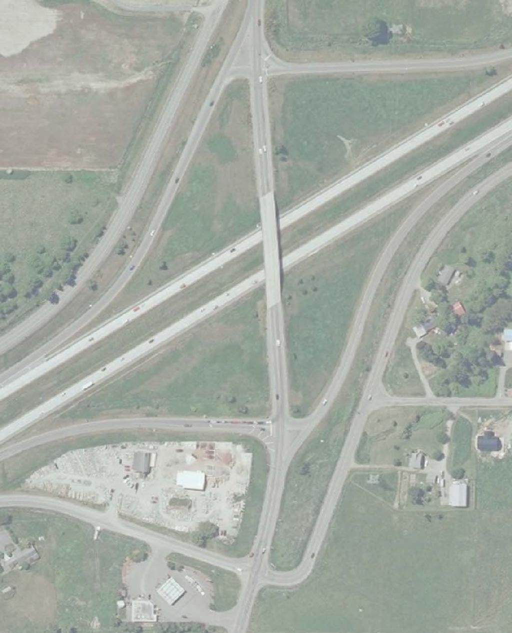
4 I-5 at Slater Road (Exit 260) Corridor Report and Interchange Justification Evaluation 1. INTRODUCTION This congestion relief and safety project is located at the southern limits of the City of Ferndale in Whatcom County. The Interstate-5 at Slater Road Interchange is exit 260. The interchange is not currently funded for improvements, but has previously been identified as needing improvements as part of the City of Ferndale Main Street Master Plan Planned Action EIS (June 2011) and as part of the WSDOT Fairhaven to Slater Interstate-5 Mater Plan (November 2008). The ultimate planned improvements can be phased to improve the ramp terminals with adjacent intersections and to ultimately replace the Interstate crossing. The preferred alternative improvements show that existing operations will be significantly improved, even with the future build-out growth of the area, and maintain acceptable LOS D for the Interstate-5 merge operations without changing the existing I-5 mainline gore line. The improvements should not require a full Interchange Justification Report. However, WSDOT recommended the traffic analysis be presented in a format similar to an Interchange Justification Report for ease of review and due to the preferred alternative including the Kope Road realignment to the southbound ramp. 2. PROJECT DESCRIPTION The Interstate-5 at Slater Road Interchange is from MP to MP The ultimate preferred improvement consists of roundabouts at the ramp terminals with Slater Road and the immediately adjacent intersections on Slater Road west of the southbound ramp, Rural Avenue, and east of the northbound ramp, Pacific Avenue. The ultimate improvements will also require widening of the Slater Road Bridge over Interstate-5. Study Corridor Exist 260 Figure 1: Site Vicinity Gibson Traffic Consultants, Inc. July 2012 info@gibsontraffic.com 1 GTC #11-130
5 I-5 at Slater Road (Exit 260) Corridor Report and Interchange Justification Evaluation 3. PROJECT PURPOSE AND NEED The purpose and need of the Slater Road Interchange improvements include: Increases safety and relieve congestion at the ramp terminals and closely spaced intersections. Accommodate the increase in traffic volume expected at the Slater Road Interchange ramp terminals and closely spaced intersections. Consistent safety and congestion/design standard improvements with the WSDOT Fairhaven to Slater Interstate-5 Mater Plan (November 2008) and the City of Ferndale Main Street Master Plan Planned Action EIS (June 2011). 4. STUDY AREA ANALYSIS AND FINDINGS The purpose of the study area analysis is as follows: What are the existing and future access needs in the corridor? Are the proposed improvements at the Interstate-5 at Slater Road Interchange necessary? Can the needs addressed by the proposed improvements be accomplished more efficiently with local infrastructure improvements? How do the proposed improvements impact the operation and safety of adjacent interchanges, the I-5 mainline and local intersections? To establish the area of influence for the proposed improvements at the Slater Road Interchange, the existing and future operating conditions and safety in the study area were evaluated. The study corridor includes the closely spaced intersection of Rural Avenue, west of the interchange, and Pacific Avenue, east of the interchange. The future build-out accounts for known developments and anticipated developments that will impact the Slater Road corridor. The 3 interchanges in the vicinity are listed below: I-5 Interchange at Bakerview Road, MP MP (Exit258) I-5 Interchange at Slater Road, MP MP (Exit 260) I-5 Interchange at Main Street, MP MP (Exit 262) The Bakerview Road and Main Street interchanges were analyzed as part of the WSDOT Fairhaven to Slater Interstate-5 Mater Plan (November 2008) and the City of Ferndale Main Street Master Plan Planned Action EIS (June 2011), respectively. However, there is potential additional growth in the area that was not included as part of either study that would impact the Slater Road interchange. Therefore, several additional improvement alternatives have been evaluated for the Slater Road corridor to determine the most appropriate interim and ultimate improvement alternatives that will provide adequate safety improvements and capacity for the potential growth in the region. Gibson Traffic Consultants, Inc. July 2012 info@gibsontraffic.com 2 GTC #11-130
6 I-5 at Slater Road (Exit 260) Corridor Report and Interchange Justification Evaluation 5. STUDY AREA METHODOLOGY The Slater Road corridor currently consists of one signalized intersection and three unsignalized intersections, which already have inadequate capacity to handle the existing traffic volumes in the area. The Main Street Master Plan Planned Action EIS (June 2011) performed for the City of Ferndale identified that some of the intersections along the Slater Road corridor currently operate at deficient levels. Additionally, the WSDOT Fairhaven to Slater Interstate-5 Mater Plan (November 2008) identified the existing Slater Road ramp deficiencies. Both of these other recent jurisdictional studies conducted detailed evaluations and alternatives analysis of the adjacent interchanges. The analysis performed for the adjacent interchanges is referenced in this study. 5.1 Intersection Level of Service Analysis The intersection level of service analysis has been performed for the 2013 existing conditions and the future build-out conditions. The future build-out conditions have also been analyzed with a Kope Road extension south of Slater Road to the north end of Bellingham International Airport. The following intersections have been analyzed: 1. Slater Road at Rural Avenue 2. Slater Road at I-5 Southbound Ramps 3. Slater Road at I-5 Northbound Ramps 4. Slater Road at Pacific Avenue Traffic congestion is measured in terms of level of service. Peak-hour level of service at intersections is determined based on the methodology described in the 2010 Highway Capacity Manual (HCM). Peak-hour level of service has been analyzed using the Synchro 8.0 Build 803 software for stop-controlled and signalized intersections. The Sidra Intersection software has been utilized for roundabout controlled intersections. WSDOT recognizes Synchro 8.0 and Sidra Intersection 6.0 as the industry standard for analyzing stop-controlled, signalized and roundabout controlled intersections. The results of the analysis are based on the Synchro 8.0 percentile level of service for signalized intersections. In accordance with the HCM, road facilities and intersections are rated between LOS A and LOS F, with LOS A being free flow and LOS F being forced flow or over-capacity conditions. A summary of the level of service criteria is included in Table 1. Geometric characteristics and conflicting traffic movements are taken into consideration when determining level of service values. The level of service at intersections is measured in terms of average control delay per vehicle in seconds. The typically acceptable level of service standard for WSDOT is LOS D, which has been utilized as the threshold for the intersections analyzed in this report. Gibson Traffic Consultants, Inc. July 2012 info@gibsontraffic.com 3 GTC #11-130
7 I-5 at Slater Road (Exit 260) Corridor Report and Interchange Justification Evaluation Table 1: Level of Service Criteria Level of 1 Expected Intersection Control Delay (Seconds per Vehicle) Service Delay Unsignalized Intersections Signalized Intersections A Little/No Delay <10 <10 B Short Delays >10 and <15 >10 and <20 C Average Delays >15 and <25 >20 and <35 D Long Delays >25 and <35 >35 and <55 E Very Long Delays >35 and <50 >55 and <80 F Extreme Delays 2 >50 >80 WSDOT utilizes a volume to capacity (v/c) ratio of 0.92 for any approach at roundabouts as the threshold to determine if it has acceptable conditions. The level of service analysis has been performed for the weekday PM peak-hour. Data for the weekday AM peak-hour and the Saturday peak-hour showed that AM peak-hour and Saturday peak-hour volumes were lower than the weekday PM peak-hour. 5.2 Turning Movement Volumes Existing traffic volumes were obtained from the Whatcom Council of Governments (WCOG), which were performed by the independent count firm of All Traffic Data (ATD). The future buildout volumes have been calculated using a combination of growth rate and specific development trips. The future build-out volumes have also been calculated with a Kope Road connection. 1 Source: Highway Capacity Manual LOS A: Free-flow traffic conditions, with minimal delay to stopped vehicles (no vehicle is delayed longer than one cycle at signalized intersection). LOS B: Generally stable traffic flow conditions. LOS C: Occasional back-ups may develop, but delay to vehicles is short term and still tolerable. LOS D: During short periods of the peak hour, delays to approaching vehicles may be substantial but are tolerable during times of less demand (i.e. vehicles delayed one cycle or less at signal). LOS E: Intersections operate at or near capacity, with long queues developing on all approaches and long delays. LOS F: Jammed conditions on all approaches with excessively long delays and vehicles unable to move at times. 2 When demand volume exceeds the capacity of the lane, extreme delays will be encountered with queuing which may cause severe congestion affecting other traffic movements in the intersection. Gibson Traffic Consultants, Inc. July 2012 info@gibsontraffic.com 4 GTC #11-130
8 I-5 at Slater Road (Exit 260) Corridor Report and Interchange Justification Evaluation Kope Road Extension The future build-out turning movement volumes have been calculated with the existing road network and with a potential new Kope Road extension to the south. The extension would occur between the existing south terminus of Kope Road, south of Slater Road, and the north terminus at the Bellingham International Airport. The change in turning movements with the Kope Road extension to the south is based on data from the WCOG model. The Kope Road extension to the south will result in the shift of an estimated 110 northbound and 65 southbound existing trips. The Kope Road extension to the south will result in a reduction in trips at the study intersections. Detailed volumes from the WCOG model with the Kope Road connection are included in the attachments Growth Rate Volume data was obtained from the WCOG model to determine a growth rate for the Slater Road corridor. WCOG volume data for the year 2008 and 2032 shows straight-line growth rates that range from 0% to 6% in the study area. Growth rates were also calculated for the 2013 to 2032 timeframe based on the existing 2013 PM peak-hour counts. The 2013 to 2032 straight-line growth rates ranged from 0% to 1%. Additionally, the WCOG 2032 to 2042 growth projections were less than 1% per year for this area. From the WCOG data it was determined that the majority of the WCOG projected growth for the Slater Road corridor occurred between 2008 and However, to account for the future growth from the WCOG model data, a 19% growth rate has been applied in the future build-out turning movement calculations before additional anticipated pipeline was included. WCOG model data showing the growth rate calculations is included in the attachments Pipeline Development The pipeline developments that are included in the future build-out volumes are additional to the growth from the WCOG model. The pipeline developments are: Costco Development (City of Bellingham) Corrections Facility (Whatcom County) Consolidated Mixed-Use Commercial Development (Lummi Nation) Traffic impact analysis reports for the Costco Development and Correction Facility have been submitted to the respective jurisdictions for review. Figures showing the PM peak-hour trip distributions for these developments are included in the attachments. The Lummi Nation has development planned that will impact the Slater Road corridor and interchange. This mixed-use development could occur in several areas west of Interstate-5. However, the highest impact on the study intersections would occur if this development is located on the south side of Slater Road, west of Interstate-5. The trips generated by future development have been calculated using standard Institute of Transportation Engineers (ITE) average trip generation rates and estimated build-out for the area. This additional potential build-out could Gibson Traffic Consultants, Inc. July 2012 info@gibsontraffic.com 5 GTC #11-130
9 I-5 at Slater Road (Exit 260) Corridor Report and Interchange Justification Evaluation consist of approximately 700,000 SF of mixed use (retail/restaurant/office) and 300 hotel rooms. These uses are anticipated to generate approximately 2,000 more PM peak-hour trips to the study area. These trips have been distributed based on WCOG model data, input from WSDOT staff and distributions from other developments in the City of Ferndale and City of Bellingham areas. The distribution for this potential build-out will change, depending on whether the Kope Road extension occurs. Distributions for each scenario, the existing road system and with the Kope Road extension, are included in the attachments Kope Road Realignment The Kope Road realignment to the southbound ramp intersection included in the preferred alternative is only anticipated to change the assignment of trips. Unlike the Kope Road extension, the Kope Road realignment will not add or remove trips from the Slater Road corridor. The Kope Road realignment can occur without or with the Kope Road extension to the south, but is only an option with the preferred alternatives of roundabouts. The Kope Road realignment has not been analyzed with any of the other improvement alternatives Total Turning Movement Volumes The future build-out peak-hour trips at the study intersections range from a 57% to 222% increase from the 2013 existing turning movements, depending on the Kope Road extension and realignment scenarios Ramp and Mainline Volumes Future build-out volumes were also calculated for the I-5 mainline and northbound and southbound on-ramps from Slater Road. These volumes have been calculated to analyze the merge conditions for the northbound and southbound on-ramps. The future build-out mainline volumes for the PM peak-hour are based on 2013 mainline volumes from WSDOT with a 1.5% straight-line growth rate for 19 years. The growth rate is based on historical volumes increases along I-5 and similar to the growth rate utilized in the Main Street Master Plan Planned Action EIS (June 2011). The future build-out ramp volumes for the PM peak-hour are based on the turning movements used for the intersection level of service analysis and are approximately 19% greater than the existing peakhour volumes. The volumes on the northbound on-ramp are the highest under the future build-out conditions with the Kope Road extension to the south. However, the volumes on the southbound on-ramp are the highest without the Kope Road extension to the south. Gibson Traffic Consultants, Inc. July 2012 info@gibsontraffic.com 6 GTC #11-130
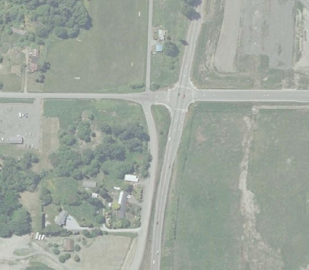
10 I-5 at Slater Road (Exit 260) Corridor Report and Interchange Justification Evaluation 5.3 Intersection Level of Service Results The 2013 existing level of service analysis shows that the intersection of Slater Road at Rural Avenue operates at LOS B, but the remaining study intersections operate at LOS F. The intersection of Slater Road at Rural Avenue operates at LOS B since it is a signalized intersection with channelization for most movements. It is important to note that the existing queue length on the northbound off-ramp identified in the analysis is approximately 650 feet (the ramp has approximately 1,200 feet of storage available). The 2013 existing volumes and level of service results at the study intersections are shown in Figure 2. Figure 2: 2013 Existing Turning Movements and Level of Service Gibson Traffic Consultants, Inc. July 2012 info@gibsontraffic.com 7 GTC #11-130
11 I-5 at Slater Road (Exit 260) Corridor Report and Interchange Justification Evaluation All of the study intersections are anticipated to operate at LOS F with severe delays under the future build-out conditions. The minor reduction in trips at the study intersections with the Kope Road extension to the south is not anticipated to significantly change the levels of service at the study intersections. Additionally, it is assumed that the queue length on the northbound off-ramp will extend beyond the 1,200 foot ramp based on the increase in delay, especially since the queue length was not able to be calculated by the software due to the volumes and delay. The future build-out turning movements and level of service results are shown in Figure 3. The preferred alternative to provide adequate capacity for the future build-out conditions is 2-lane roundabouts. Figure 3: Future Build-Out Turning Movements and Level of Service Gibson Traffic Consultants, Inc. July 2012 info@gibsontraffic.com 8 GTC #11-130
12 I-5 at Slater Road (Exit 260) Corridor Report and Interchange Justification Evaluation 5.4 Ramp Merge Level of Service Results The ramp merge level of service results were calculated using the HCM 2010 methodology, similar to the study intersection analysis. The ramp merge analysis was performed using factors provided by WSDOT and included in their previous analysis of the ramp merge areas. The ramp merge analysis based on the highest volumes and the results are summarized in Table 2. Table 2: Future Build-Out Ramp Merge Analysis Summary Direction Volume Analysis Merge Area (Future Build-Out Volumes 3 Ramp Density ) Speed Volume Acceptable Density Speed Mainline Ramp Capacity LOS Total Capacity (pc/mi/ln) (mph) Northbound Merge 3, ,900 4,800 Yes 30.5 D 60.1 Southbound Merge 2,615 1,520 4,135 4,800 Yes 32.0 D 61.1 The ramp merge analysis shows that the northbound and southbound on-ramp merge areas are anticipated to operate at acceptable capacity, with an acceptable density and with an acceptable speed. It is important to note that the change in volumes without or with the Kope Road extension is minor and the analysis has been performed with the highest volumes of the different scenarios. The ramp merge analysis therefore represents a conservatively high analysis of the ram merge. The ramp merge calculations are included in the attachments. 6. STUDY AREA COLLISION ANALYSIS The Main Street Master Plan Planned Action EIS (June 2011) documented the collision history in the City of Ferndale area, including the Slater Road corridor. The Main Street Master Plan Planned Action EIS analyzed data from October 2007 to October 2010 provided by WSDOT. The analysis showed that none of the study intersections had more than 4 collisions per year or a collision rate of more than 1.0 per million entering vehicles. Slater Road at the southbound ramp was included as one of the intersections with the highest collision history in the Main Street Master Plan Planned Action EIS (June 2011). 7. STUDY AREA ANALYSIS CONCLUSIONS To determine the area of influence for the proposed improvements along the Slater Road corridor at the Interstate-5 interchange, the study area analysis was focused on providing answers to the questions posed in Section 4. Reponses to those questions are listed below. 3 These volumes include factors for heavy vehicles, driver population and peak-hour factors. Gibson Traffic Consultants, Inc. July 2012 info@gibsontraffic.com 9 GTC #11-130
13 I-5 at Slater Road (Exit 260) Corridor Report and Interchange Justification Evaluation What are the existing and future access needs in the corridor? The Interstate-5 interchange at Slater Road and the adjacent closely spaced intersections do not have programmed improvements. However, the WSDOT Fairhaven to Slater Interstate-5 Master Plan (November 2008) and the City of Ferndale Main Street Master Plan Planned Action EIS (June 2011) documented that there are existing deficient levels of service along the Slater Road corridor at the Interstate-5 interchange. In addition, the future build-out analysis shows that additional improvements to the intersections are required to accommodate the regional growth. The proposed improvements of 2-lane roundabouts, realigned Kope Road to the southbound ramp intersection and Slater Road Bridge widening will accommodate the future full build-out projections at the Slater Road interchange. Improvements to the Interstate-5 mainline or ramps, outside of the terminals at Slater Road, were documented in the WSDOT Fairhaven to Slater Interstate-5 Mater Plan (November 2008) and the City of Ferndale Main Street Master Plan Planned Action EIS (June 2011) reports and are unchanged in this report based on the future buildout ramp merge analysis showing acceptable operations. The analysis also demonstrated that an interim improvements to the southbound and northbound ramp intersections would accommodate approximately 75% of the future anticipated mixed-use area growth. The interim improvements include the Kope Road realignment to the southbound ramp intersection, partial 2-lane roundabouts at the southbound and northbound intersections, restriping of the Interstate-5 undercrossing bridge and a 1-lane roundabout at the Pacific Avenue intersection. The Rural Avenue signal can be retained under the interim conditions with minor modifications. Is the proposed access revision at the Interstate-5 at Slater Road necessary? Yes. There is an existing and worsening safety and operational problem. The analysis shows that the northbound and southbound Interstate-5 ramp terminals at Slater Road and the Slater Road at Pacific Avenue intersection currently operate at LOS F. In addition, the 95 th Percentile queue on the northbound off-ramp is anticipated to impact the I-5 northbound mainline volumes. The improvements are necessary to improve the existing and future operation of the intersections and reduce the existing and future queue impacts of the northbound off-ramp on the Interstate-5 northbound mainline. Can the needs addressed by the proposed improvements be accomplished more efficiently with local infrastructure improvements? No. The Slater Road corridor is an important east-west corridor that provides access to areas between the City of Bellingham and the City of Ferndale and is the primary access for the Lummi Nation. These improvements are necessary to maintain acceptable operations to access these areas since no other efficiently accessible connections to Interstate-5 exist. The options for local infrastructure improvements were assessed in both the WSDOT Fairhaven to Slater Interstate-5 Mater Plan (November 2008) and the City of Ferndale Main Street Master Plan Planned Action EIS (June 2011) reports and both concluded that the Slater Road interchange improvements were Gibson Traffic Consultants, Inc. July 2012 info@gibsontraffic.com 10 GTC #11-130
14 I-5 at Slater Road (Exit 260) Corridor Report and Interchange Justification Evaluation needed even with any local improvements. Additionally, the WCOG modeling showed that a Kope Road extension to the south only removed 175 trips from the interchange; which is insufficient to improve the operations of the intersections. How do the proposed improvements impact the operation and safety of adjacent interchanges, the I-5 mainline and local intersections? There is no change to the number of interchange ramp access connections to the mainline and the existing gore line for the Slater Road interchange ramp connections are not proposed to change. The northbound and southbound ramp terminals and the Pacific Avenue intersection currently operate at LOS F. The proposed improvements will improve the safety of the Interstate-5 mainline (reduction of impacts of northbound off-ramp queues) and the operation of the local intersections (operation of LOS D or better). The study area analysis indicates there is significant benefit to the safety and operation of the ramp terminal intersections and adjacent local intersections at the Slater Road corridor with the proposed improvements, with no negative impacts to operations and safety on the mainline and adjacent interchanges. Given these findings, it is anticipated that a full Interchange Justification Report is not warranted for the proposed improvements. However, the traffic analysis needed to support that decision is organized below similar to an IJR to help make the review easier. WSDOT and the City of Ferndale have completed two major corridor studies recently that included the Slater Road intersections with the southbound and northbound ramps and adjacent Main Street and Bakerview Road interchanges. No new interchanges or significant arterial connections were recommended in either of these adopted studies. WCOG and WSDOT have planned a major regional study, but the study is not anticipated to be completed for a couple of years. This WCOG and WSDOT study will use the same existing WCOG traffic data included in this study. Based on a preliminary review, it is not anticipated that any of the future options being reviewed in the WCOG and WSDOT study would have any significant change to the recommendations in this study. 8. POLICY POINT #1 NEED FOR THE ACCESS POINT REVISION 8.1 Project Description The proposed full improvements will provide 2-lane roundabouts with slip-lanes, if required, along Slater Road at the intersections with Rural Avenue, the Interstate-5 southbound ramps, the Interstate-5 northbound ramps and Pacific Avenue. The Interstate-5 mainline and ramps are not proposed to be changed. The Slater Road Bridge over Interstate-5 will also need to be widened as part of the future build-out conditions; although interim improvements to the bridge would accommodate approximately 75% of the future projected growth before the full improvements are required. Gibson Traffic Consultants, Inc. July 2012 info@gibsontraffic.com 11 GTC #11-130
15 I-5 at Slater Road (Exit 260) Corridor Report and Interchange Justification Evaluation The need for the intersection improvements include: Deficient operation of the study intersections under the existing and future build-out conditions. Future queue lengths on the northbound off-ramp are anticipated to impact the Interstate-5 mainline traffic under the future build-out conditions. 8.2 Analysis and Data Improvements to the Slater Road corridor was identified as part of the Main Street Master Plan Planned Action EIS performed for the City of Ferndale. The existing data is based on data from WCOG and an independent count firm. The Synchro 8.0 Build 803 and Sidra Intersection software were used to analyze the existing and proposed improvements. Traffic volumes were calculated for future build-out conditions with the existing street system and with a Kope Road extension to the south. Additionally, the preferred alternative with the roundabouts was analyzed with a Kope Road realignment at the southbound ramp terminal to create a 5-leg roundabout. The growth for the future build-out conditions is based on WCOG growth projections for the area and additional planned development west of I-5. The future build-out is the equivalent of an additional 57% to 222% increase in peak-hour trips at the study intersections from the 2013 existing turning movements, depending on the scenario. Depending on the rate of development, the improvements are anticipated to accommodate regional and local growth for a 20 to 30-year horizon. 9. POLICY POINT #2 - REASONABLE ALTERNATIVES There were several alternatives that were analyzed as part of this analysis. These alternatives included: Signalization with channelization Single-Point Urban Interchange (SPUI) Diverging Diamond Roundabouts The alternatives were all evaluated for the future build-out conditions with the existing street system. The potential Kope Road extension to the south results in a reduction in trips at the study intersections. Therefore the alternatives have been evaluated with the highest anticipated volumes at the study intersections. The reasonable alternatives were evaluated based on the operation (level of service), queuing, cost and ability for phasing. Gibson Traffic Consultants, Inc. July 2012 info@gibsontraffic.com 12 GTC #11-130
16 I-5 at Slater Road (Exit 260) Corridor Report and Interchange Justification Evaluation 9.1 Signal Improvements The signal improvements alternative required extensive widening and channelization to allow the study intersections to operate at LOS D or better under the future build-out conditions. The level of service results with extensive improvement, bridge widening and signalization is summarized in Table 3. Table 3: Level of Service Summary with Signal Alternative Intersection 1. Slater Rd at Rural Ave 2. Slater Rd at I-5 SB Ramps 3. Slater Rd at I-5 NB Ramps 4. Slater Rd at Pacific Ave 2013 Existing Future Build-Out Conditions Conditions No Imp w Roundabouts w Signals LOS Delay LOS Delay LOS Delay LOS Delay B 13.7 sec F sec B v/c D 45.1 sec F 85.1 sec F >1000 sec B v/c C 20.0 sec F sec F >1000 sec B v/c C 25.7 sec F sec F >1000 sec B 0.678v/c C 23.6 sec The level of service calculations is included in the attachments. There are two main reasons why signalization was not the preferred alternative, improvements to the I-5 undercrossing bridge and queuing. The signal alternative will require the I-5 undercrossing bridge to be a 6-lane structure to allow two lanes in each direction and two eastbound left-turn lanes at the I-5 Northbound Ramps. In comparison, the preferred alternative of roundabouts only requires a 4-lane I-5 undercrossing bridge. The cost comparison of the signal alternative and the preferred roundabout alternative is summarized in Table 4. Table 4: Cost Estimate Summary for Signal Alternative Alternative Rural Road Rural to I-5 Ramp Pacific Avenue Intersection Ramps Link Intersections Intersection Total Roundabouts $1,700,000 $1,000,000 $14,600,000 $1,700,000 $19,000,000 Signalization $2,000,000 $2,500,000 $15,000,000 $1,500,000 $21,000,000 It is important to note that these are planning level costs and assume some economies of scale since the corridor improvements would be constructed at the same time, as opposed to being phased. The lane configuration for the signal alternative that is documented in Table 3 was necessary to prevent queue backups between intersections and onto the I-5 mainline. Even with the signal alternative lane configuration, there are queue backups that could occur between the closely spaced I-5 Northbound Ramps and the Pacific Avenue intersections that could significantly impact the operation of both intersections. Gibson Traffic Consultants, Inc. July 2012 info@gibsontraffic.com 13 GTC #11-130
17 I-5 at Slater Road (Exit 260) Corridor Report and Interchange Justification Evaluation The signal alternative is not the preferred alternative due to the costs and the potential queue backups. 9.2 Single-Point Urban Interchange A Single-Point Urban Interchange (SPUI) was evaluated for the interchange with signals at the Rural Avenue and Pacific Avenue intersections. The SPUI alternative results show all of the study intersections operating at an acceptable level of service with the future build-out conditions. The level of service is summarized in Table 5. Table 5: Level of Service Summary with SPUI Alternative Intersection 1. Slater Rd at Rural Ave 2. Slater Rd at I-5 SB Ramps 3. Slater Rd at I-5 NB Ramps 4. Slater Rd at Pacific Ave 2013 Existing Future Build-Out Conditions Conditions No Imp w Roundabouts w SPUI LOS Delay LOS Delay LOS Delay LOS Delay B 13.7 sec F sec B v/c D 45.1 sec F 85.1 sec F >1000 sec B v/c F sec F >1000 sec B v/c C 30.2 sec F sec F >1000 sec B 0.678v/c C 23.6 sec It is important to note that it has been assumed that the Rural Avenue and Pacific Avenue intersections will operate at the same level of service as the signal alternative with the SPUI alternative. The level of service calculations is included in the attachments. The SPUI improvement is difficult to phase, as compared to the preferred roundabout improvements and signal alternative, and therefore intermediate improvements necessitated by growth must be timed accurately. The SPUI is also the most expensive of the alternatives that were analyzed. The cost summary is included in Table 6. Table 6: Cost Estimate Summary for SPUI Alternative Alternative Rural Road Rural to I-5 Ramp Pacific Avenue Intersection Ramps Link Intersections Intersection Total Roundabouts $1,700,000 $1,000,000 $14,600,000 $1,700,000 $19,000,000 SPUI $2,000,000 $2,000,000 $37,000,000 $2,000,000 $43,000,000 The SPUI alternative was not chosen as the preferred alternative due to the cost of the improvements and the inability to phase the improvements. Gibson Traffic Consultants, Inc. July 2012 info@gibsontraffic.com 14 GTC #11-130
18 I-5 at Slater Road (Exit 260) Corridor Report and Interchange Justification Evaluation 9.3 Diverging Diamond Alternative The diverging diamond alternative is an interchange configuration that eliminates the left-turns onto the on-ramps, which typically have the longest delays and queue lengths at an interchange. The Rural Avenue and Pacific Avenue intersections have been analyzed as signalized intersections with this alternative. The level of service analysis, which is summarized in Table 7, shows that all of the study intersections operate at acceptable levels with this alternative. Table 7: Level of Service Summary with Diverging Diamond Alternative Intersection 1. Slater Rd at Rural Ave 2. Slater Rd at I-5 SB Ramps 3. Slater Rd at I-5 NB Ramps 4. Slater Rd at Pacific Ave 2013 Existing Future Build-Out Conditions Conditions No Imp w Roundabouts w Div.Dia. LOS Delay LOS Delay LOS Delay LOS Delay B 13.7 sec F sec B v/c D 45.1 sec F 85.1 sec F >1000 sec B v/c C 23.7 sec F sec F >1000 sec B v/c C 22.9 sec F sec F >1000 sec B 0.678v/c C 20.9 sec It is important to note that it has been assumed that the Rural Avenue intersection will operate at the same level of service as the signal alternative with the Diverging Diamond alternative. The level of service calculations is included in the attachments. The diverging diamond improvement will provide adequate queuing, but is also difficult to phase like the SPUI alternative. In addition, the diverging diamond will likely lead to driver confusion since it is not a typical interchange configuration. The cost summary is included in Table 8. Table 8: Cost Estimate Summary for Diverging Diamond Alternative Alternative Rural Road Rural to I-5 Ramp Pacific Avenue Intersection Ramps Link Intersections Intersection Total Roundabouts $1,700,000 $1,000,000 $14,600,000 $1,700,000 $19,000,000 Diverging Diamond $2,000,000 $2,500,000 $16,400,000 $2,000,000 $22,400,000 The diverging diamond alternative was not chosen as the preferred alternative due to the cost of the improvements, the inability to phase the improvements and the potential for driver confusion. Gibson Traffic Consultants, Inc. July 2012 info@gibsontraffic.com 15 GTC #11-130
19 I-5 at Slater Road (Exit 260) Corridor Report and Interchange Justification Evaluation Lane Roundabouts Preferred Alternative The preferredd alternative for the improvements is 2-lane roundabouts. The Slater Road intersection improvements will include a 2-lane roundabout with a fifth leg for a Kope Road realignment at the southbound ramp. The Rural Avenue roundabout will have two-lane approaches for the eastbound and westbound approaches and the eastbound departure will have two-lanes. The remaining approaches and departures will only require one-lane. The I-5 Southbound Ramps will include a fifth leg in the southwest quadrant for a Kope Road realignment. The southbound ramp will require 2-lane approaches and departures on all legs, except the approach in the southwest quadrant. The approach in the southwest quadrant will require the addition of a slip lane for the movement onto the southbound on-ramp. The I-5 Northbound Ramps will also require 2-lanes on all approaches and departures, except for the northbound departure, which will only require one lane. This lane configuration will require the I-5 undercrossing bridge to be widened to allow two lanes in each direction. The Pacific Avenue intersection will require 2-lanes on the approaches and departures on the west side. The remaining approaches and departures will only require one lane. A figure showing the preferred alternative for the future build-out conditions is shown in Figure 4. Gibson Traffic Consultants, Inc. July 2012 info@gibsontraffic.com 16 GTC #11-130


20
21 I-5 at Slater Road (Exit 260) Corridor Report and Interchange Justification Evaluation 10. POLICY POINT #3 OPERATION AND COLLISION ANALYSIS This section summarizes the operation analysis of the preferred alternative. The analysis was performed for the following conditions: 2013 existing conditions future interim conditions future build-out conditions 10.1 Existing Configuration The 2013 existing conditions level of service analysis has been performed with the existing volumes shown in Figure 2, existing lane configuration, existing peak-hour factors and existing heavy-vehicle factors. The future build-out analysis has been analyzed utilizing the volumes shown in Figure 3 and the existing channelization and control. Gibson Traffic Consultants, Inc. July 2012 info@gibsontraffic.com 18 GTC #11-130
22 I-5 at Slater Road (Exit 260) Corridor Report and Interchange Justification Evaluation The 2013 existing level of service analysis shows that the intersection of Slater Road at Rural Avenue operates at LOS B, but the remaining study intersections operate at LOS F. The intersection of Slater Road at Rural Avenue operates at an acceptable level of service since it has channelization and is signalized. All of the study intersections are anticipated to operate at LOS F with severe delays under the future build-out conditions without any improvements. The level of service of the study intersections is summarized in Table 9. Table 9: Level of Service Summary Intersection 1. Slater Rd at Rural Ave 2. Slater Rd at I-5 SB Ramps 3. Slater Rd at I-5 NB Ramps 4. Slater Rd at Pacific Ave 2013 Existing Conditions Future Build-Out Conditions LOS Delay LOS Delay B 13.7 sec F sec F 85.1 sec F >1000 sec F sec F >1000 sec F sec F >1000 sec 10.2 Future Interim Conditions Future interim conditions were analyzed to determine the amount of development that can occur with only minor improvements to the Interstate-5 undercrossing bridge. The interim improvements assume three lanes across the bridge (2 westbound and 1 eastbound) with sidewalk and or reduced shoulder width on one side. The future build-out volumes include a growth rate and three pipeline developments. Two of the pipeline developments, the Costco development and the Corrections Facility development, have already been submitted to their respective jurisdictions. Additional mixed use developments west of Interstate-5 have been projected to account for approximately 2,000 PM peak-hour trips in the area. The future interim improvements were analyzed with a 3-lane bridge (2 westbound lanes and 1 eastbound lane) and partial 2-lane roundabouts at the ramp terminals. It was determined that 75% of the mixed-use development west of Interstate-5 could be accommodated (in addition to the growth rate and other pipeline developments) by these improvements. Additionally, the Rural Avenue signal would only require minor changes, assuming the Kope Road realignment to a 5-leg roundabout at the southbound ramp intersection. The Pacific Avenue roundabout would also be able to be phased to a 1-lane roundabout under the interim conditions. The future interim volumes and level of service are shown in Figure 5. Gibson Traffic Consultants, Inc. July 2012 info@gibsontraffic.com 19 GTC #11-130
23 I-5 at Slater Road (Exit 260) Corridor Report and Interchange Justification Evaluation Figure 5: Future Interim Volumes and Level of Service with Preferred Alternative The future interim conditions level of service results are summarized in Table 10. Table 10: Level of Service Summary with Future Interim Improvements Intersection 1. Slater Rd at Rural Ave 2. Slater Rd at I-5 SB Ramps 3. Slater Rd at I-5 NB Ramps 4. Slater Rd at Pacific Ave 2013 Existing Future Interim Conditions Conditions No Imp w Roundabouts LOS Delay LOS Delay LOS Delay B 13.7 sec F sec C 27.0 sec F 85.1 sec F >1000 sec B v/c F sec F >1000 sec B v/c F sec F >1000 sec B v/c Gibson Traffic Consultants, Inc. July 2012 info@gibsontraffic.com 20 GTC #11-130
24 I-5 at Slater Road (Exit 260) Corridor Report and Interchange Justification Evaluation The Rural Avenue at Slater Road intersection is able to remain as a signalized intersection under the future interim conditions with the Kope Road realignment to southbound ramp intersection since the level of service is acceptable and the queue lengths for the westbound approach, the queue lengths between the Rural Avenue and southbound ramps intersection, will be less than 350 feet. This queue length is not anticipated to disrupt the operation of the southbound ramp intersection. The phased improvements to the Slater Road corridor are anticipated to save approximately $6,000,000 from the cost of the ultimate improvements. The interim improvements along the Slater Road corridor are shown in Figure Future Build-Out Growth Conditions The future build-out conditions have been analyzed without and with a Kope Road extension to the south between the south terminus of Kope and northern end of Bellingham International Airport. Additionally, an analysis of the improvements required without and with a Kope Road realignment at the southbound ramp has been performed Kope Road Extension and Realignment The effects of the Kope Road extension to the south is based on data from the WCOG model. The model data shows that there are anticipated to be 110 northbound and 65 southbound trips along Kope Road with the connection and these trips are anticipated to come from the northbound and southbound ramps, respectively. The Kope Road extension to the south is anticipated to result in 10% of the traffic from the mixed-use development west of Interstate-5 utilizing Kope Road, which is approximately 200 peak-hour trips. The Kope Road connection to the south is therefore anticipated to reduce the volume along the Slater Road corridor. Additionally, a realignment of Kope Road to create a fifth leg at the southbound ramp in the southwest quadrant has been analyzed. This fifth leg would also serve as an access to development south of Slater Road. The realignment of Kope Road to the southbound ramp intersection has a significant benefit on the improvements required along the corridor, especially for the Rural Avenue intersection. The analysis of the Kope Road extension to the south, but without the Kope Road realignment to the southbound ramp intersection, and the future build-out volumes shows that the Rural Avenue intersection will require at least two lanes on all approaches and departures with slip lanes for the eastbound and northbound right-turn lanes. This is compared to fewer approach and departure lanes and no slip lanes with the Kope Road realignment to the southbound ramp intersection. As for the southbound ramp intersection, there is very little difference without and with the Kope Road realignment. The Kope Road realignment will not require any additional lanes on any of the existing approaches or departures of the southbound ramp. Additionally, the eastbound approach at the southbound ramp, which has the critical v/c ratio, is actually anticipated to decrease (improved operations) with the Kope Road realignment. A comparison of the required lane configuration and results for the Rural Avenue and southbound ramp intersections without and with the Kope Road realignment is included in the attachments. Gibson Traffic Consultants, Inc. July 2012 info@gibsontraffic.com 21 GTC #11-130

25
26 I-5 at Slater Road (Exit 260) Corridor Report and Interchange Justification Evaluation In addition to decreasing the volumes along the Slater Road corridor, decreasing the required improvements at the Rural Avenue intersection and not significantly impacting the southbound ramp; the Kope Road extension and realignment will reduce the travel length for vehicles destined to and from the south without sacrificing any other movements. For these reasons, the Kope Road realignment to the southbound ramp intersection has been included as part of the preferred alternative. However, the future build-out volumes with the Kope Road extension to the south have not been utilized in the future build-out analysis for two reasons: 1. The Kope Road extension to the south results in lower volumes along the Slater Road corridor, a. Therefore, not utilizing the Kope Road extension to the south represents a conservatively high analysis of the Slater Road corridor. 2. There is not currently right-of-way for the Kope Road extension to the south, which could prevent the extension from occurring without extensive tunneling or wetland mitigation. 3. Although the Kope Road extension to the south removes trips from the Slater Road corridor, the reduction in trips is not enough to change the required improvements to maintain LOS D conditions. The volumes shown in Figure 7 for the future build-out conditions therefore include the Kope Road realignment, but not the Kope Road extension to the south. Gibson Traffic Consultants, Inc. July 2012 info@gibsontraffic.com 23 GTC #11-130
27 I-5 at Slater Road (Exit 260) Corridor Report and Interchange Justification Evaluation Figure 7: Future Build-Out Volumes and Level of Service with Preferred Alternative The preferred alternative for the future build-out conditions is 2-lane roundabouts for all study intersections, with slip lanes for critical movements. The level of service results with future buildout improvements are shown in Table 11. Table 11: Level of Service Summary with Future Build-Out Improvements Intersection 1. Slater Rd at Rural Ave 2. Slater Rd at I-5 SB Ramps 3. Slater Rd at I-5 NB Ramps 4. Slater Rd at Pacific Ave 2013 Existing Future Interim Conditions Future Build-Out Conditions Conditions No Imp w Roundabouts No Imp w Roundabouts LOS Delay LOS Delay LOS Delay LOS Delay LOS Delay B 13.7 sec F sec C 27.0 sec F sec B v/c F 85.1 sec F >1000 sec B v/c F >1000 sec B v/c F sec F >1000 sec B v/c F >1000 sec B v/c F sec F >1000 sec B v/c F >1000 sec B 0.678v/c Gibson Traffic Consultants, Inc. July 2012 info@gibsontraffic.com 24 GTC #11-130
28 I-5 at Slater Road (Exit 260) Corridor Report and Interchange Justification Evaluation The channelization at the study intersections with the preferred alternative is shown in Figure 4 and the level of service calculations are included in the attachments. 11. POLICY POINT #4 ACCESS CONNECTIONS AND DESIGN The preferred alternative of 2-lane roundabouts will maintain the fully directional function of the existing interchange. Changes to the Interstate-5 mainline and the ramps, outside of the terminals at Slater Road, are not proposed as part of the preferred alternatives. The preferred alternative will not change the existing spacing between interchanges along Interstate-5 or the intersections along Slater Road. The future interim alternative includes a 3-lane Slater Road bridge over Interstate-5. This 3-lane bridge can be constructed within the existing 2-lane bridge, although deviations to WSDOT would need to be required. The future build-out alternative will require the Interstate-5 undercrossing bridge to be reconstructed. 12. POLICY POINT #5 LAND USE AND TRANSPORTATION PLANS The preferred alternatives are consistent with what is included in the adopted WSDOT Fairhaven to Slater Interstate-5 Mater Plan (November 2008) and the City of Ferndale Main Street Master Plan Planned Action EIS (June 2011). Neither study identified any new interchanges or significant arterial connections in this influence area. The preferred alternative is also consistent with Lummi Nation plans and the traffic counts are consistent with what is being used by WCOG for the latest regional access plan. Additionally, preliminary review indicates the proposed improvements would not be altered or alter any preliminary scenarios being reviewed in the WCOG regional plan. 13. POLICY POINT #6 FUTURE INTERCHANGES There are no future interchanges to Interstate-5 that are currently proposed in the vicinity of the Slater Road interchange. 14. POLICY POINT #7 COORDINATION The preferred alternative is similar to what was analyzed for the WSDOT Fairhaven to Slater Interstate-5 Mater Plan (November 2008) and the City of Ferndale Main Street Master Plan Planned Action EIS (June 2011). Improvements to the study intersections will be coordinated with the City of Ferndale, Whatcom County and Lummi Nation. Gibson Traffic Consultants, Inc. July 2012 info@gibsontraffic.com 25 GTC #11-130
29 I-5 at Slater Road (Exit 260) Corridor Report and Interchange Justification Evaluation 15. POLICY POINT #8 ENVIRONMENTAL PROCESS The preferred alternatives will need to be evaluated for the State Environmental Policy Act (SEPA) and the National Environmental Policy Act (NEPA) processes. 16. ACCESS AND DESIGN CONCLUSIONS In conclusion, the preferred alternative will improve the operations the study intersections and the safety of the northbound off-ramp queue impacts on the northbound Interstate-5 mainline. Gibson Traffic Consultants, Inc. July GTC #11-130
30 Counts, Growth and Pipeline Data A
31 Rural Ave & Slater Rd 4:15 PM to 5:15 PM Tuesday, April 09, Peds E U) d N a Peds 0 Slater Rd Approach PHF HV% EB % WB % NB % SB % Intersection % Volume ,423 Count Period: 4:00 PM to 6:00 PM A - 1
32 Out 475 In 564 Rural Ave & Slater Rd Tuesday, April 09, :00 PM to 6:00 PM 15-Minute Interval Summary 4:00 PM to 6:00 PM Interval Start Northbound Rural Ave Southbound Rural Ave Eastbound Slater Rd Westbound Slater Rd Interval Pedestrians Crosswalk Time L T R HV L T R HV L T R HV L T R HV Total North South East West 4:00 PM :15 PM :30 PM :45 PM :00 PM :15 PM :30 PM :45 PM Total Survey ,648 1 Peak Hour Summary 4:15 PM to '5:15 PM By Approach Volume %HV PHF In 85 Northbound Rural Ave Out Total % 0.57 HV Southbound Rural Ave In Out Total % 0.76 Eastbound Slater Rd Westbound Slater Rd HV In Out Total HV In Out Total HV , , % 4.6% Total 1, % 0.95 North 0 Pedestrians Crosswalk South East 0 0 West 0 Northbound Southbound Eastbound Westbound By Rural Ave Rural Ave Slater Rd Slater Rd Total Movement L T R Total L T R Total L T R Total L T R Total Volume ,423 PHF _ Rolling Hour Summary 4:00 PM to 6:00 PM Interval Northbound Southbound Eastbound Westbound Pedestrians Start Rural Ave Rural Ave Slater Rd Slater Rd Interval Crosswalk Time L T R HV L I T R HV L T R HV L T R HV Total North South East West 4:00 PM , :15 PM , :30 PM , :45 PM , :00 PM _ , A - 2
33 SB Ramps & Slater Rd 4:15 PM to 5:15 PM Tuesday, April 09, Slater Rd 9 Peds E N a m Peds 0 Slater Rd Approach PHF HV% EB % WB % NB % SB % Intersection % Volume ,555 Count Period: 4:00 PM to 6:00 PM A - 3
34 o _ = Out 583 In 737 o 294.-$ In 330 Out SB Ramps & Slater Rd Tuesday, April 09, :00 PM to 6:00 PM out Peak Hour Summary 4:15 PM to 5:15 PM 15-Minute Interval Summary 4:00 PM to 6:00 PM Interval Start Northbound SB Ramps Southbound SB Ramps Eastbound Slater Rd Westbound Slater Rd Interval Pedestrians Crosswalk Time L T R HV L T R HV L T R HV L T R HV Total North South East West 4:00 PM :15 PM :30 PM :45 PM :00 PM :15 PM :30 PM :45 PM Total Survey ,903 1 Peak Hour Summary 4:15 PM to 5:15 PM Northbound Southbound Eastbound Westbound Pedestrians By SB Ramps SB Ramps Slater Rd Slater Rd Total Crosswalk Approach In Out Total HV In Out Total HV In Out Total HV In Out Total HV North South East West Volume , , ,555 1 %HV 0.0% 8.0% 2.4% 3.8% 3.4% PHF Northbound Southbound Eastbound Westbound By SB Ramps SB Ramps Slater Rd Slater Rd Movement L T R Total L T R Total L T R Total L T R Total Total Volume ,555 PHF Rolling Hour Summary 4:00 PM to 6:00 PM Interval Start Northbound SB Ramps Southbound SB Ramps Eastbound Slater Rd Westbound Slater Rd Interval Pedestrians Crosswalk Time L T R HV L T R HV L T R HV L T R HV Total North South East West 4:00 PM , :15 PM , :30 PM , :45 PM , :00 PM _ _ ,393 1 A - 4
35 NB Ramps & Slater Rd 4:15 PM to 5:15 PM Tuesday, April 09, Slater Rd + Peds E N a Peds 0 Slater Rd Approach PHF HV% EB % WB % NB % SB % Intersection % Volume ,361 Count Period: 4:00 PM to 6:00 PM A - 5
36 Out 721 In 329 NB Ramps & Slater Rd Tuesday, April 09, :00 PM to 6:00 PM 15-Minute Interval Summary 4:00 PM to 6:00 PM Interval Start Northbound NB Ramps Southbound NB Ramps Eastbound Slater Rd Westbound Slater Rd Interval Pedestrians Crosswalk Time L T R HV L T R HV L T R HV L T R HV Total North South East West 4:00 PM :15 PM :30 PM :45 PM :00 PM :15 PM :30 PM :45 PM Total Survey ,545 0 Peak Hour Summary 4:15 PM to 5:15 PM Northbound Southbound Eastbound Westbound Pedestrians By NB Ramps NB Ramps Slater Rd Slater Rd Total Crosswalk Approach In Out Total HV In Out Total HV In Out Total HV In Out Total HV North South East West Volume _ , , ,361 0 %HV 4.3% 0.0% 3.6% 2.2% 3.2% PHF Northbound Southbound Eastbound Westbound By NB Ramps NB Ramps Slater Rd Slater Rd Movement L T R Total L T R Total L T R Total L T R Total Total Volume ,361 PHF Rolling Hour Summary 4:00 PM to 6:00 PM Interval Start Northbound NB Ramps Southbound NB Ramps Eastbound Slater Rd Westbound Slater Rd Interval Pedestrians Crosswalk Time L T R HV L T R HV L T R HV L T R HV Total North South East West 4:00 PM , :15 PM , :30 PM , :45 PM , :00 PM _ _ ,205 0 A - 6
37 Pacific Hwy & Slater Rd 4:15 PM to 5:15 PM Tuesday, April 09, It + Slater Rd Peds E C Peds 0 Slater Rd Approach PHF 'HV% EB % WB % NB % SB % Intersection % Volume ,124 Count Period: 4:00 PM to 6:00 PM A - 7
38 Out 591 In 435 Pacific Hwy & Slater Rd Tuesday, April 09, :00 PM to 6:00 PM 15-Minute interval Summary 4:00 PM to 6:00 PM Interval Start Northbound Pacific Hwy Southbound Pacific Hwy Eastbound Slater Rd Westbound Slater Rd Interval Pedestrians Crosswalk Time L T R HV L T R HV L T R HV L T R HV Total North South East West 4:00PM :15PM :30PM :45 PM :00PM :15 PM :30 PM :45 PM Total Survey ,053 1 Peak Hour Summary 4:15 PM to 5:15 PM Northbound Southbound Eastbound Westbound Pedestrians. By Pacific Hwy Pacific Hwy Slater Rd Slater Rd Total Crosswalk Approach In Out Total HV In I Out Total HV In Out Total HV In Out Total HV North South East West Volume , ,124 1 %HV 0.5% 1.9% 2.3% 2.4% 2.0% PHF Northbound Southbound Eastbound Westbound By Pacific Hwy Pacific Hwy Slater Rd Slater Rd Total Movement L T R Total L T R Total L T R Total L T R Total Volume ,124 PHF Rolling Hour Summary 4:00 PM to 6:00 PM Interval Northbound Southbound Eastbound Westbound Pedestrians Start Pacific Hwy Pacific Hwy Slater Rd Slater Rd Interval Crosswalk Time L T R HV L T R HV L T R HV L T R HV Total North South East West 4:00 PM , :15 PM , :30 PM , :45 PM , :00 PM A - 8

39 Year PM to 6 PM Volumes with Kope Rd Phase 2 Without Development ,847 2, , , Disclaimer: This map was prepared by Whatcom Council of Governments' staff at the request of a consultant working on behalf of a member of the Whatcom Transportation Policy Board, based on parameters established by the consultant. The results contained herein should not be construed nor represented as an endorsement of the project by the Whatcom Council of Governments, the Whatcom Transportation Policy Board or the Transportation Technical Advisory Committee. 4 7 A - 9
Section III Part N Traffic Impact Report and Correspondence
 Section III Part N Traffic Impact Report and Correspondence TRAFFIC IMPACTS ADDENDUM AMSTERDAM VILLAGE GALLATING COUNTY, MONTANA Erik Garberg, P.E. December, 2014 411 East Main, Suite 101 Bozeman, MT 59715
HCM 6: Highway Capacity Manual: A Guide for Multimodal Mobility Analysis
 HCM 6: Highway Capacity Manual: A Guide for Multimodal Mobility Analysis Presented by: Anita S Johari, PE, PTOE AMEC Foster Wheeler (ASJ Engineering Consultants) Assisted by: Vishwanathan Raja Gopalan,
Technical Traffic Evaluation for the Dog Hotel Project at 6344 Arizona Circle
 Overland Traffic Consultants, Inc. 952 Manhattan Beach Boulevard #100 Manhattan Beach, CA 90266 Phone (310) 930-3303 E-mail: otc@overlandtraffic.com March 29, 2016 Mr. Solomon Alter Director of Development
Kumeu/Huapai Waitakere to Swanson Public Transport Options
 Kumeu/Huapai Waitakere to Swanson Public Transport Options Recommendations It is recommended that the Board: i). Receive the report ii). iii). iv). Approve not pursuing the diesel train option for the
NCHRP Project Production of a Major Update to the Highway Capacity Manual 2010
 NCHRP Project 03-115 Production of a Major Update to the Highway Capacity Manual 2010 Working Paper #3 HCM 2010 Update Audience, Purpose, and Need Prepared by: Wayne Kittelson Kittelson & Associates, Inc.
REPORT TO PLANNING COMMISSION City of Sacramento
 REPORT TO PLANNING COMMISSION City of Sacramento 915 I Street, Sacramento, CA 95814-2671 9 PUBLIC HEARING March 10, 2011 To: Members of the Planning Commission Subject: Cha Cha s Doggie Daycare (P10-086)
More panthers, more roadkills Florida panthers once ranged throughout the entire southeastern United States, from South Carolina
 Mark Lotz Florida Panther Biologist, Florida Fish & Wildlife Conservation Commission Darrell Land Florida Panther Team Leader, Florida Fish & Wildlife Conservation Commission Florida panther roadkills
COUNTY OF ALBEMARLE STAFF REPORT SUMMARY
 COUNTY OF ALBEMARLE STAFF REPORT SUMMARY Project Name: SP201000008 The Canine Clipper Dog Grooming and Boarding Planning Commission Public Hearing: July 27, 2010 Owner: Amy Peloquin Acreage: 6.126 Staff:
Highways: Interstate. Highways: State Highways. Highways: Off State Hwy Sys/Off Fed Sys. Maintenance: Interstate. Maintenance: State Highways
 FLORIDA DEPARTMENT OF TRANSPORTATION 5 - YEAR TRANSPORTATION PLAN ($ IN THOUSANDS) TENTATIVE FY 2019-2023 (10/01/2017 20:15:01) SUWANNEE COUNTY Highways: Interstate 4413371 I-10 FROM: MADISON COUNTY LINE
REPORT TO THE CHIEF ADMINISTRATIVE OFFICER FROM THE DEVELOPMENT AND ENGINEERING SERVICES DEPARTMENT
 November 19, 2015 REPORT TO THE CHIEF ADMINISTRATIVE OFFICER FROM THE DEVELOPMENT AND ENGINEERING SERVICES DEPARTMENT ON REZONING APPLICATION NO. REZ00576 DEVELOPMENT VARIANCE PERMIT APPLICATION NO. DVP00458
Case 2:07-cr MMB Document 39 Filed 06/23/08 Page 1 of 7 IN THE UNITED STATES DISTRICT COURT FOR THE EASTERN DISTRICT OF PENNSYLVANIA
 Case 2:07-cr-00371-MMB Document 39 Filed 06/23/08 Page 1 of 7 IN THE UNITED STATES DISTRICT COURT FOR THE EASTERN DISTRICT OF PENNSYLVANIA UNITED STATES OF AMERICA v. JERRY BLASSENGALE, JR. : : : CRIMINAL
Document Information. Quality Assurance Register. Auckland Transport. NZ1700 Auckland PT Development Plan
 Document Information Client Job Number Title Prepared by Auckland Transport NZ1700 Auckland PT Development Plan MRCagney Pty Ltd Auckland, New Zealand Date 14 February 2013 Quality Assurance Register Issu
CIVICS DIRECTOR S NOTES MARCH 19, MONTHLY BOARD MEETING
 DEVELOPMENT AND REZONING REZONING 615 SECORD BOULEVARD CIVICS DIRECTOR S NOTES MARCH 19, 2018 - MONTHLY BOARD MEETING Many residents expressed concerns about this rezoning which would have seen the site
PROCEEDINGS OF THE ST. CLOUD PLANNING COMMISSION. A meeting of the St. Cloud Planning Commission was held on April 14, 2009, at 7 p.m.
 PROCEEDINGS OF THE ST. CLOUD PLANNING COMMISSION A meeting of the St. Cloud Planning Commission was held on April 14, 2009, at 7 p.m. in the City Hall Council Chambers. Members present were Andzenge, Chirhart,
North Florida. Agricultural, Recreational & Development Tracts. Bank Owned. Suwannee County, FL
 North Florida Agricultural, Recreational & Development Tracts Suwannee County, FL River Acres 910 +/- Acres Offers Taken Until July 19, 2013 Adjacent to the Suwannee River State Park 2.25 miles frontage
Total Funding Requested: $25, Putnam County Board of County Commissioners.
 Grant ID: 1785 Title of Proposal: 2018 Low Cost Spay/Neuter Grant Agency Type: Municipal Total Funding Requested: $25,000.00 Check Payable To: Putnam County Board of County Commissioners Application Information
TRANSIT SERVICES ADVISORY COMMITTEE Meeting Summary Thursday January 13, 2011
 TRANSIT SERVICES ADVISORY COMMITTEE Meeting Summary Thursday January 13, 2011 PRESENT: STAFF: Rick Sanderson, Charlotte Anthony Wesley, Charlotte Christine Bryant, Huntersville Rob Cornwell, Davidson Dee
Grant ID: 220. Application Information. Demographics.
 Grant ID: 220 Title of Proposal: Putnam County No-Cost Spay Neuter Program Agency Type: Municipal Total Funding Requested: $25,000.00 Check Payable To: Putnam County BOCC Application Information Demographics
EAGLE RIVER/CHUGIAK PARKS & RECREATION DEPARTMENT
 M u n i c i p a l i t y o f A n c h o r a g e APRIL 2018 DRAFT EAGLE RIVER/CHUGIAK PARKS & RECREATION DEPARTMENT DRAFT DOG PARKS SITE SELECTION CRITERIA Prepared by R&M Consultants, Inc. Contents Introduction...
Effects of Cage Stocking Density on Feeding Behaviors of Group-Housed Laying Hens
 AS 651 ASL R2018 2005 Effects of Cage Stocking Density on Feeding Behaviors of Group-Housed Laying Hens R. N. Cook Iowa State University Hongwei Xin Iowa State University, hxin@iastate.edu Recommended
https://secure.ehwebsolutions.com/faf/application_view_submit... Jacksonville Animal Care and Protective Services
 Grant ID: 1450 Title of Proposal: Fix-A-Bull Agency Type: Municipal Total Funding Requested: $25,000.00 Check Payable To: City of Jacksonville Application Information Demographics Name of Applicant Agency:
SOSSAMAN CLOUD PARK. Site Conditions
 SOSSAMAN CLOUD PARK distant views of the Superstition Mountains to the northeast. A series of dirt roads are visible throughout the site and trash and debris from local neighborhoods are present. A graded
Insert the title of your presentation here
 Insert the title of your presentation here Hpw do 1 st and 2 nd generation TSD s compare results of a UK trial Presented by Name Here Job Title - Date Brian Ferne, TRL National Pavement Evaluation Conference
Mayor Savage and Members of Halifax Regional Council. Original Signed. Trap Neuter and Release (TNR) Program Funding Request
 Program Funding Request") HALIFAX P.O. Bait 1749 Halifax, Nova Scotia B3J 3A5 Canada Item No. 14.2.3 Halifax Regional Council April 26, 2016 TO: Mayor Savage and Members of Halifax Regional Council SUBMITTED BY: Original Signed
HALIFAX P.O. Bait 1749 Halifax, Nova Scotia B3J 3A5 Canada Item No. 14.2.3 Halifax Regional Council April 26, 2016 TO: Mayor Savage and Members of Halifax Regional Council SUBMITTED BY: Original Signed
Effective Vaccine Management (EVM) Global Data Analysis
 Global Data Analysis") Effective Vaccine Management (EVM) Global Data Analysis 2010-2013 EVM setting a standard for the vaccine supply chain Update: WHO EVM database, December 2014 1 The Effective Vaccine Management (EVM) Assessmentg
Effective Vaccine Management (EVM) Global Data Analysis 2010-2013 EVM setting a standard for the vaccine supply chain Update: WHO EVM database, December 2014 1 The Effective Vaccine Management (EVM) Assessmentg
EXECUTIVE SUMMARY FOR A PRESENCE/ ABSENCE SURVEY FOR THE DESERT TORTOISE (Gopherus agassizii),
,") C.5 Desert Tortoise EXECUTIVE SUMMARY FOR A PRESENCE/ ABSENCE SURVEY FOR THE DESERT TORTOISE (Gopherus agassizii), on the proposed Alta Oak Creek Mojave Wind Generation Project near Mojave, Kern County,
C.5 Desert Tortoise EXECUTIVE SUMMARY FOR A PRESENCE/ ABSENCE SURVEY FOR THE DESERT TORTOISE (Gopherus agassizii), on the proposed Alta Oak Creek Mojave Wind Generation Project near Mojave, Kern County,
Premium List. Entries limited to (7) Tracking Dog Urban - Event #
 Tracking Dog Urban - Event #") Premium List Entries limited to (7) Tracking Dog Urban - Event # 2017025617 Open to all AKC Breeds and All American Dogs enrolled in AKC Canine Partners Two test workers option will be set aside for this
Premium List Entries limited to (7) Tracking Dog Urban - Event # 2017025617 Open to all AKC Breeds and All American Dogs enrolled in AKC Canine Partners Two test workers option will be set aside for this
WEEKLY UPDATE AUGUST 1, 2016 AUGUST 5, 2016
 PUBLIC MEETINGS AUGUST 1 AUGUST 5, 2016 WEEKLY UPDATE AUGUST 1, 2016 AUGUST 5, 2016 THURSDAY, AUGUST 4 3 p.m.-horry County Planning Commission, Horry County Government & Justice Center, Multipurpose Rooms,
UNLISTED ACCESSORY USE DETERMINATION: OUTDOOR OFF-LEASH DOG ENCLOSURE ACCESSORY TO EATING PLACE
 Community Planning and Development Development Services Zoning Administration 201 W Colfax Ave, Dept 205 Denver, CO 80202 p: 720-865-2915 f: 720-865-3056 http://www.denvergov.org/developmentservices UNLISTED
Effective Vaccine Management (EVM) Global Data Analysis
 Global Data Analysis") Effective Vaccine Management (EVM) Global Data Analysis 2009-2014 EVM setting a standard for the vaccine supply chain Update: WHO EVM database, December 2015 1 The Effective Vaccine Management (EVM) Assessmentg
Effective Vaccine Management (EVM) Global Data Analysis 2009-2014 EVM setting a standard for the vaccine supply chain Update: WHO EVM database, December 2015 1 The Effective Vaccine Management (EVM) Assessmentg
DRAFT PUBLIC SPACES MASTER PLAN. POPS Advisory Committee October 30, 2017
 PUBLIC SPACES MASTER PLAN NOTE: This presentation is a working document, and some recommendations or ideas may have evolved or changed based on continued discussions and additional analyses. POPS Advisory
Dog Off Leash Strategy
 STRATHCONA COUNTY Dog Off Leash Strategy Phase 2 Report: Consultation Summary December 03, 2014 ENCLOSURE 4 STRATHCONA COUNTY Dog Off Leash Strategy Phase 2 Report: Consultation Summary ENCLOSURE 4 Table
IQ Range. Electrical Data 3-Phase Power Supplies. Keeping the World Flowing
 IQ Range Electrical Data 3-Phase Power Supplies Keeping the World Flowing Contents Section Page Introduction 3 50 Hz 380 V 5 0 V 6 415 V 7 4 V 8 500 V 9 6 V 60 Hz 8 V 11 2 V 0 V 13 4 V 14 460 V 15 480
Moorhead, Minnesota. Photo Credit: FEMA, Evaluating Losses Avoided Through Acquisition: Moorhead, MN
 Moorhead, Minnesota Photo Credit: FEMA, 2010. Evaluating Losses Avoided Through Acquisition: Moorhead, MN Background Moorhead is a midsize city (pop. 38,065) in Clay County, Minnesota. The largest city
A Column Generation Algorithm to Solve a Synchronized Log-Truck Scheduling Problem
 A Column Generation Algorithm to Solve a Synchronized Log-Truck Scheduling Problem Odysseus 2012 Greg Rix 12 Louis-Martin Rousseau 12 Gilles Pesant 13 1 Interuniversity Research Centre on Enterprise Networks,
Alberta Conservation Association 2017/18 Project Summary Report
 Alberta Conservation Association 2017/18 Project Summary Report Project Name: Pronghorn Road Crossing Enhancement (Pronghorn Xing) Wildlife Program Manager: Doug Manzer Project Leader: Paul Jones Primary
Animal Use Subcommittee. Post Approval Monitoring Policy Approved: September 13, 2012 Supersedes: August 13, Goal. Mandate
 Goal The goal of the post approval monitoring (PAM) program is to collaboratively and collegially ensure that animal-based work at Western and affiliated institutions aligns with approved Animal Use Protocol
King Fahd University of Petroleum & Minerals College of Industrial Management
 King Fahd University of Petroleum & Minerals College of Industrial Management CIM COOP PROGRAM POLICIES AND DELIVERABLES The CIM Cooperative Program (COOP) period is an essential and critical part of your
Livestock: Transport and Markets Student Activities
 Module 25 Livestock: Transport and Markets Questions 1. Name a farm animal species for whom heat stress likely to be a problem, and state why this is the case? (2 marks) Pigs and poultry, since they both
LONG RANGE PERFORMANCE REPORT. Abstract
 State: Georgia Grant Number: 08-953 Study Number: 6 LONG RANGE PERFORMANCE REPORT Grant Title: State Funded Wildlife Survey Period Covered: July 1, 2012 - June 30, 2013 Study Title: Wild Turkey Production
NADAC SANCTIONED AGILITY TRIAL (North American Dog Agility Council)
") NADAC SANCTIONED AGILITY TRIAL (North American Dog Agility Council) Hosted by: NADAC DATES: August 3-5 2018 LOCATION: DOGWOOD ACRES W6825 County Road O Hortonville, WI JUDGE: Judges from the current NADAC
NADAC SANCTIONED AGILITY TRIAL (North American Dog Agility Council) Hosted by: NADAC DATES: August 3-5 2018 LOCATION: DOGWOOD ACRES W6825 County Road O Hortonville, WI JUDGE: Judges from the current NADAC
Public Hearing and Work Session
 Public Hearing and Work Session Agenda Item # 1 and 2 Meeting Date June 2, 2014 Prepared By Approved By Suzanne Ludlow Deputy City Manager Brian T. Kenner City Manager Discussion Item Background Dog Park
STRATHCONA COUNTY. Dog Off Leash Strategy
 STRATHCONA COUNTY Dog Off Leash Strategy February 2015 ENCLOSURE 2 STRATHCONA COUNTY Dog Off Leash Strategy Executive Summary Strathcona County currently provides one designated dog off leash park Deermound
TECHNICAL BULLETIN Claude Toudic Broiler Specialist June 2006
 Evaluating uniformity in broilers factors affecting variation During a technical visit to a broiler farm the topic of uniformity is generally assessed visually and subjectively, as to do the job properly
EGULAR MEETING OF THE PLANNING COMMISSION Dearborn, Michigan. March 07, 2016
 EGULAR MEETING OF THE PLANNING COMMISSION Dearborn, Michigan March 07, 2016 The regular meeting was called to order at 7:03 p.m. by Chairperson Siwik. Upon roll call, the following members were present:
The Heifer Facility Puzzle: The New Puzzle Pieces
 The Heifer Facility Puzzle: The New Puzzle Pieces Joe Harner Biological and Agricultural Engineering Kansas State University Manhattan, KS jharner@ksu.edu / 785.532.2900 Dan McFarland Sr Extension Educator
Conservation and Management of Burmese Python in Bangladesh
 Conservation and Management of Burmese Python in Bangladesh Interim Report October 2018 Shahriar Caesar Rahman Creative Conservation Alliance House 925, Road 13 A, Avenue 3 Mirpur DOHS caesar@conservationalliance.org
Modeling and Control of Trawl Systems
 Modeling and Control of Trawl Systems Karl-Johan Reite, SINTEF Fisheries and Aquaculture Supervisor: Professor A. J. Sørensen * Advisor: Professor H. Ellingsen * * Norwegian University of Science and Technology
The Science of Pet Safety
 1.800.324.3659 www.centerforpetsafety.org February 3, 2012 Crashworthiness Analysis of Canine Automotive Restraint (Size Large) Lindsey A. Wolko Center for Pet Safety Automotive travel for companion animals
HONORABLE MAYOR AND MEMBERS OF THE CITY COUNCIL SUBJECT: DOG BEACH PILOT PROGRAM AT RANCHO PALOS VERDES. BEACH
 CITY OF RANCHO PALOS VERDES TO: FROM: DATE: HONORABLE MAYOR AND MEMBERS OF THE CITY COUNCIL CAROLYNN PETRU, DEPUTY CITY MANAGERIINTERI~ RECREATION AND PARKS DIRECTOR APRIL 3, 2012 SUBJECT: DOG BEACH PILOT
2013 AVMA Veterinary Workforce Summit. Workforce Research Plan Details
 2013 AVMA Veterinary Workforce Summit Workforce Research Plan Details If the American Veterinary Medical Association (AVMA) says the profession is experiencing a 12.5 percent excess capacity in veterinary
List of the Major Changes to CKC Agility for 2014
 List of the Major Changes to CKC Agility for 2014 New Games: 1. Points and Distance - PAD This strategic titling game involves the accumulation of points within a specified time, and incorporates a distance
EUROPEAN COMMISSION DIRECTORATE-GENERAL FOR HEALTH AND FOOD SAFETY
 EUROPEAN COMMISSION DIRECTORATE-GENERAL FOR HEALTH AND FOOD SAFETY Health and food audits and analysis DG(SANTE) 2017-6110 FINAL REPORT OF A FACT-FINDING MISSION CARRIED OUT IN TURKEY FROM 05 SEPTEMBER
Rutting: Causes, Prevention, and Repairs
 Rutting: Causes, Prevention, and Repairs Chance Liley Illinois Asphalt Pavement Association February, 2018 Rutting is a term for when permanent deformation or consolidation accumulates in an asphalt pavement
BEVERLY HILLS STAFF REPORT. Meeting Date: August 4, 2015 To: From: Subject:
 BEVERLY HILLS STAFF REPORT Meeting Date: August 4, 2015 To: From: Subject: Attachments: Honorable Mayor & City Council Steven Zoet, Director of Community Services Review of Proposed Dog Park Design Concepts
Skilled Occupation List
 Skilled Occupation List 2015-16 Submission from the Australian Veterinary Association Ltd 14 th November 2014 Contact: Dr Deborah Neutze nssm@ava.com.au 02 9431 5000 0412 262 825 Executive summary The
Complete Solutions for BROILER BREEDERS
 Complete Solutions for BROILER BREEDERS Global Presence Local Commitment Feeding Drinking Climate Housing Complete Broiler Breeder Packages Broiler-Breeders We at Plasson are aware that the main goal in
Covers. Now with 75 1/4" [1910] Grade Level Box BULK mm 74.08in BODY DESIGN BODY SPECIFICATIONS FEATURES TESTING CRITERIA
![Covers. Now with 75 1/4 [1910] Grade Level Box BULK mm 74.08in BODY DESIGN BODY SPECIFICATIONS FEATURES TESTING CRITERIA](/thumbs/93/111391861.jpg "Covers. Now with 75 1/4 [1910] Grade Level Box BULK mm 74.08in BODY DESIGN BODY SPECIFICATIONS FEATURES TESTING CRITERIA") ULK 9 Series ULK 9 Series ODY DESIGN ODY SPECIFICATIONS Cover Weight (Split 1/2 Cover) 89 lbs Straight wall design improves lid load strength. A [40 kg] Pit Weight 363 lbs [165 kg] Assembled Weight 541
ULK 9 Series ULK 9 Series ODY DESIGN ODY SPECIFICATIONS Cover Weight (Split 1/2 Cover) 89 lbs Straight wall design improves lid load strength. A [40 kg] Pit Weight 363 lbs [165 kg] Assembled Weight 541
AVMA 2015 Report on the Market for Veterinarians
 AVMA 2015 Report on the Market for Veterinarians In 2011, the AVMA made a commitment to move beyond its traditional ad hoc workforce studies and establish an economics division with the charge of providing
American Association of State Highway and Transportation Officials 444 North Capitol Street, N.W., Suite 249 Washington, D.C.
 American Association of State Highway and Transportation Officials 444 North Capitol Street, N.W., Suite 249 Washington, D.C. 20001 The Special Committee on U.S. Route Numbering met on Friday, May 6, 2005
WEEKLY UPDATE JANUARY 14 18, 2019
 PUBLIC MEETINGS MONDAY, JANUARY 14 WEEKLY UPDATE JANUARY 14 18, 2019 5:30 p.m. Horry County Zoning Board of Appeals, Horry County Government & Justice Center, 1301 Second Avenue, Multipurpose Rooms, Conway.
THURSDAY and FRIDAY, MARCH 30 & 31, 2017
 SOUTHWEST OREGON BULLDOG CLUB Licensed by the American Kennel Club, Inc. INDOORS / OUTDOORS - UNBENCHED SPECIALTIES SWEEPSTAKES JUNIOR SHOWMANSHIP OBEDIENCE RALLY THURSDAY and FRIDAY, MARCH 30 & 31, 2017
WHO (HQ/MZCP) Intercountry EXPERT WORKSHOP ON DOG AND WILDLIFE RABIES CONTROL IN JORDAN AND THE MIDDLE EAST. 23/25 June, 2008, Amman, Jordan
 Intercountry EXPERT WORKSHOP ON DOG AND WILDLIFE RABIES CONTROL IN JORDAN AND THE MIDDLE EAST. 23/25 June, 2008, Amman, Jordan") WHO (HQ/MZCP) Intercountry EXPERT WORKSHOP ON DOG AND WILDLIFE RABIES CONTROL IN JORDAN AND THE MIDDLE EAST 23/25 June, 2008, Amman, Jordan Good practices in intersectoral rabies prevention and control
WHO (HQ/MZCP) Intercountry EXPERT WORKSHOP ON DOG AND WILDLIFE RABIES CONTROL IN JORDAN AND THE MIDDLE EAST 23/25 June, 2008, Amman, Jordan Good practices in intersectoral rabies prevention and control
OFFICE OF THE CITY ADMINISTRATIVE OFFICER
 REPORT FROM OFFICE OF THE CITY ADMINISTRATIVE OFFICER Date: To: From: Reference: Subject: June 2, 2010 CAO File No. 0160-01544-0000 The Council Council File No. Council District: Miguel A. Santana, City
Long-distance Live Transport: Common problems and practical solutions
 Long-distance Live Transport: Common problems and practical solutions Over the last several years, investigations into long-distance live transport have identified ten frequently recurring yet preventable
M A R Y L A N D SHEEP & WOOL F E S T I V A L
 January 12th, 2018 M A R Y L A N D SHEEP & WOOL F E S T I V A L Dear Exhibitors, Hopefully this letter finds you and your flock in good health and in the midst of a very successful lambing season for 2018!
SECTION IV-1 PARLOURS
 SECTION IV-1: PARLOURS 1 SECTION IV-1 PARLOURS 1. PARLOURS Parlours are effective milking management systems on many dairy sheep operations. The ability to milk a number of ewes at one time allows for
The courses are divided into sections or exercises: Pen or sheepfold Difficult passages Handling and maneuvering Stopping the flock
 BSCA French Course The BSCA French course is intended to provide a venue to evaluate Belgian Sheepdogs and similar herding breeds in non boundary tending work on both sheep and cattle. The primary intent
HAT HILL DOG OFF-LEASH AREA MODIFICATIONS
 HAT HILL DOG OFF-LEASH AREA MODIFICATIONS Draft Package of Works for comment prior to presentation to Council Background The area of the pending land sale at Hat Hill in Blackheath covers just under half
4--Why are Community Documents So Difficult to Read and Revise?
 4--Why are Community Documents So Difficult to Read and Revise? Governing Documents are difficult to read because they cover a broad range of topics, have different priorities over time, and must be read
3 days: 4 Obedience Trials & 4 Rally Trials Accepting Entries for All AKC Recognized Breeds & Dogs Listed as ILP, PAL, or AKC Canine Partners
 AKC Licensed Obedience & Rally Trials Unbenched Premium List Poodle Club of Las Vegas 3 days: 4 Obedience Trials & 4 Rally Trials Accepting Entries for All AKC Recognized Breeds & Dogs Listed as ILP, PAL,
Hydraulic Report. County Road 595 Bridge over Yellow Dog River. Prepared By AECOM Brian A. Hintsala, P.E
 Prepared for: Prepared by: Marquette County Road Commission AECOM Ishpeming, MI Marquette, MI 60240279 December 9, 2011 Hydraulic Report County Road 595 Bridge over Yellow Dog River Prepared By AECOM Brian
Agvet Chemicals Task Group Veterinary Prescribing and Compounding Rights Working Group
 Agvet Chemicals Task Group Veterinary Prescribing and Compounding Rights Working Group Submission from the Australian Veterinary Association Ltd www.ava.com.au The Australian Veterinary Association Limited
TD/TDX TRACKING TEST PREMIUM LIST
 BTCSC Tracking Test Secretary Teri Meredyth 1666 261 st St. Harbor City, CA 90710 TD/TDX TRACKING TEST PREMIUM LIST BELGIAN TERVUREN CLUB OF SOUTHERN CALIFORNIA Meet at Elm Group Campsite (tent camping
Service Animal Procedure, Student and Community Procedure
 STOCKTON UNIVERSITY PROCEDURE Service Animal Procedure, Student and Community Procedure Procedure Administrator: Chief Officer for Institutional Diversity and Equity Authority: Americans with Disabilities
Chintimini Kennel Club Lure Coursing Practices Goals, Schedules and Locations Practice Schedule (last updated 11 June 2018)
") Chintimini Kennel Club Lure Coursing Practices Goals, Schedules and Locations Practice Schedule (last updated 11 June 2018) Day of the Week Date Time Location Status Sunday 24 June 2pm Junction City Practice
Chintimini Kennel Club Lure Coursing Practices Goals, Schedules and Locations Practice Schedule (last updated 11 June 2018) Day of the Week Date Time Location Status Sunday 24 June 2pm Junction City Practice
Use of Restricted Veterinary Medicines for Induction in the New Zealand Dairy Industry: Audit Summary
 Use of Restricted Veterinary Medicines for Induction in the New Zealand Dairy Industry: Audit Summary June 2013 1. Introduction 2. Scope 3. Background 4. Audit Summary 5. Recommendations Appendix: Conditions
Total Funding Requested: $25, Pasco County Board of County Commissioners
 Grant ID: 1693 Title of Proposal: Targeted Trap-Neuter-Release Program Agency Type: Municipal Total Funding Requested: $25,000.00 Check Payable To: Pasco County Board of County Commissioners Application
THURSDAY and FRIDAY, MARCH 29 & 30, 2018
 SOUTHWEST OREGON BULLDOG CLUB Licensed by the American Kennel Club, Inc. INDOORS / OUTDOORS - UNBENCHED SPECIALTIES SWEEPSTAKES JUNIOR SHOWMANSHIP OBEDIENCE RALLY THURSDAY and FRIDAY, MARCH 29 & 30, 2018
What we heard. Protecting the rights of people who rely on guide and service animals in Nova Scotia. Public discussion
 Protecting the rights of people who rely on guide and service animals in Nova Scotia Public discussion What we heard Prepared by the Policy, Planning, and Research Branch, Department of Justice Fall 2015
REPORT ON SCOTTISH EID TRIALS
 REPORT ON SCOTTISH EID TRIALS PREPARED FOR: SEERAD PREPARED BY: SAOS Ltd Rural Centre West Mains Ingliston, EH28 8NZ January 2007 CONTENTS 1. Introduction 2 Page 2. Trial Objectives. 2 3. Methodology..
Jumpers Judges Guide
 Jumpers events will officially become standard classes as of 1 January 2009. For judges, this will require some new skills in course designing and judging. This guide has been designed to give judges information
Independent Dog Agility Shows
 Independent Dog Agility Shows Winter Shows in Derby with Leagues for all classes Class 21 - Steeplechase Qualifiers to be held over lunch Final to be held on Saturday 4 th August at our show in Cheshire
Halifax County Lamb & Heifer Show
 Halifax County Lamb & Heifer Show Sunday, August 20, 2017 Location: Halifax County 4-H Rural Life Center/Horse & Livestock Arena 54 Dog Pound Road, Halifax, NC 27839 Market Lamb: Check-in: 8-9:30 a.m.
Determination of Seasonal Adjustment Factors for Vehicle Class Counts
 Determination of Seasonal Adjustment Factors for Vehicle Class Counts February 2011 Traffic Forecasting and Analysis Section Office of Transportation Data and Analysis Seasonal adjustment factors are used
FAQ (Frequently Asked Questions)
") File: FAQ-FCI-Updated-12-21-12 Page: 1 of 11 Table of Contents Pg(s) I. Benefits of using FCI s... 1 II. Installation... 2-5 III. AccQTrip for OLM & UCM Models... 5 IV. Adaptive trip Logic for 1547 & 1548
File: FAQ-FCI-Updated-12-21-12 Page: 1 of 11 Table of Contents Pg(s) I. Benefits of using FCI s... 1 II. Installation... 2-5 III. AccQTrip for OLM & UCM Models... 5 IV. Adaptive trip Logic for 1547 & 1548
Rules and Course Requirements by Level/Title. Barn Hunt Instinct (RATI)
") Rules and Course Requirements by Level/Title Barn Hunt Instinct (RATI) Prerequisite: None. Dogs may enter this class and Novice in the same Trial. Dogs may continue to enter this class until the Novice
Rules and Course Requirements by Level/Title Barn Hunt Instinct (RATI) Prerequisite: None. Dogs may enter this class and Novice in the same Trial. Dogs may continue to enter this class until the Novice
Off-leash Dog Beaches & Parks Community Engagement Report. September 2016
 Off-leash Dog Beaches & Parks Community Engagement Report September 2016 1 Executive Summary Provision for dogs in any community generates strong, frequently polarized, opinions on the subject. While this
505 Hamm Road Suite 101, Windermere Court. Abbotsford, BC V2T 4J2. Suite 2600, Three Bentall Centre 840 Howe Street PO Box 49314
 File: 44200-50/CMB 03-09 DELIVERED BY FAX Mr. Ernie Silveri President General Manager BC Egg Hatchery Association BC Chicken Marketing Board 505 Hamm Road Suite 101, Windermere Court Abbotsford, BC V2S
9: Coffee Break. 10:00-11: Spatial Risk Mapping (Thomas Van Boekel) 11:00-12: Dynamic Bayesian Network (Yrjo Grohn)
 11:00-12: Dynamic Bayesian Network (Yrjo Grohn)") NIMBioS AMR Working Group: Evaluating the Association between Shifts in Antimicrobial Use Practices and Antimicrobial Resistance Resulting from FDA s Risk Mitigation Strategy The overall objective: To
NIMBioS AMR Working Group: Evaluating the Association between Shifts in Antimicrobial Use Practices and Antimicrobial Resistance Resulting from FDA s Risk Mitigation Strategy The overall objective: To
Read Any Trailing or Tracking Dog
 Read Any Trailing or Tracking Dog by Understanding Negative Indications Kevin Kocher & Robin Monroe Read any Trailing or Tracking Dog Copyright by Kevin J. Kocher & Robin Monroe Illustrations and design
WOOL DESK REPORT MAY 2007
 Issue no. 008 ISSN: 1449-2652 WOOL DESK REPORT MAY 2007 FLOCK DEMOGRAPHICS AND PRODUCER INTENTIONS RESULTS OF A NATIONAL SURVEY CONDUCTED IN FEBRUARY 2007 KIMBAL CURTIS Department of Agriculture and Food,
1.0 SUMMARY OF THE ACTIVITY UNDERTAKEN TO PROTECT AND ENHANCE THE ENVIRONMENT: PROJECT OBJECTIVES, SOLUTIONS AND ACHIEVEMENTS
 EXECUTIVE SUMMARY Blanding s Turtles nest in the granular shoulders of roadways, burying eggs beneath the ground surface. Visual detection of nests is not possible. Highway rehabilitation can damage or
Organization Business Address: 965 Pondella Rd. State: Florida Zip: Phone (xxx xxx xxxx): Fax:
: Fax:") Grant ID: 1646 Title of Proposal: 2016 Large Dog Agency Type: Non Profit Total Funding Requested: $25,000.00 Check Payable To: P.A.W.S. Lee County Inc Application Information Demographics Name of Applicant
Grant ID: 1646 Title of Proposal: 2016 Large Dog Agency Type: Non Profit Total Funding Requested: $25,000.00 Check Payable To: P.A.W.S. Lee County Inc Application Information Demographics Name of Applicant
Bernese Mountain Dog Club of America, Inc. (Member of the American Kennel Club)
") Entries close at 11:00 PM (PDT), May 19, 2018, after which time entries cannot be accepted, canceled, or altered, except as specifically allowed in the current BMDCA Draft Test Regulations. Make checks
Entries close at 11:00 PM (PDT), May 19, 2018, after which time entries cannot be accepted, canceled, or altered, except as specifically allowed in the current BMDCA Draft Test Regulations. Make checks
Veterinary Medical Education in Texas: An Update
 AGENDA ITEM VI C Veterinary Medical Education in Texas: An Update Texas Higher Education Coordinating Board July 2016 1 Questions Regarding Veterinary Education in Texas Does Texas need another veterinary
2014 WASTE PROPOSAL. Charlie Hamilton
 2014 WASTE PROPOSAL CD WASTE MANAGEMENT The purpose of this proposal is to show how our total waste management service can transform Orpington High Street and save local businesses money. Charlie Hamilton
American Rescue Dog Association. Standards and Certification Procedures
 American Rescue Dog Association Standards and Certification Procedures American Rescue Dog Association Section II Area Search Certification Date Last Updated: October 2014 Date Last Reviewed: May 2016
DOGS IN OPEN SPACES STRATEGY:
 DOGS IN OPEN SPACES STRATEGY: A 10-YEAR STRATEGY TO GUIDE THE PLANNING, DESIGN AND MANAGEMENT OF OFF LEASH AREAS IN EDMONTON EXECUTIVE SUMMARY JANUARY 2016 Executive Summary January 2016 2 EXECUTIVE SUMMARY
Larimer Humane Society. New Facility Program and Schematic Design Executive Summary Updated 9/4/14
 Larimer Humane Society New Facility Program and Schematic Design Executive Summary Updated 9/4/14 I. Project Background In late 2007, Larimer Humane Society purchased 27 acres of land at 3437 and 3501